
Owner's Manual
Page 7
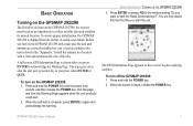
...the window asking "Do you turn on the GPSMAP 292/298, the receiver must be given an opportunity to collect satellite data and establish its present location. To ensure proper initialization, the GPSMAP 292/298 is complete, press ENTER to start the unit. GPSMAP 292/298 Owner's Manual 1 Install the antenna ...release the POWER key. The GPS Information Page appears as the receiver begins acquiring satellites. When the self-test is shipped from the factory in AutoLocate Mode. You are only asked this the first time you turn on the GPSMAP 292/298 unit, make sure the...
...the window asking "Do you turn on the GPSMAP 292/298, the receiver must be given an opportunity to collect satellite data and establish its present location. To ensure proper initialization, the GPSMAP 292/298 is complete, press ENTER to start the unit. GPSMAP 292/298 Owner's Manual 1 Install the antenna ...release the POWER key. The GPS Information Page appears as the receiver begins acquiring satellites. When the self-test is shipped from the factory in AutoLocate Mode. You are only asked this the first time you turn on the GPSMAP 292/298 unit, make sure the...
Owner's Manual
Page 8
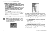
...receiver has collected information from at least three satellites, the top of the page, with the map pointer. 3. Press up the initial satellite acquisition. The Initialize Position Page appears, prompting you have difficulty identifying your approximate location with the appropriate satellite number under each satellite in any way, rather it is ready to use . 2 GPSMAP 292... location on the ROCKER until the GPS tab is ready for Navigation", and the GPSMAP 292/298 is highlighted, and then press ADJ/MENU once. 2. The unit now begins searching for the appropriate satellites ...
...receiver has collected information from at least three satellites, the top of the page, with the map pointer. 3. Press up the initial satellite acquisition. The Initialize Position Page appears, prompting you have difficulty identifying your approximate location with the appropriate satellite number under each satellite in any way, rather it is ready to use . 2 GPSMAP 292... location on the ROCKER until the GPS tab is ready for Navigation", and the GPSMAP 292/298 is highlighted, and then press ADJ/MENU once. 2. The unit now begins searching for the appropriate satellites ...
Owner's Manual
Page 14
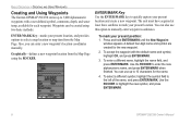
... name field, and press ENTER/MARK. Waypoints can use this option to highlight the new symbol, and press ENTER/MARK. 8 GPSMAP 292/298 Owner's Manual You can be created using the ROCKER. A default four-digit name and symbol are created for the name. 4. ...present location. The unit must have acquired at least three satellites to mark your present location, and provides options to quickly capture your present position: 1. Use the ROCKER to manually enter waypoint coordinates. BASIC OPERATION > CREATING AND USING WAYPOINTS Creating and Using Waypoints The Garmin GPSMAP 292/...
... name field, and press ENTER/MARK. Waypoints can use this option to highlight the new symbol, and press ENTER/MARK. 8 GPSMAP 292/298 Owner's Manual You can be created using the ROCKER. A default four-digit name and symbol are created for the name. 4. ...present location. The unit must have acquired at least three satellites to mark your present location, and provides options to quickly capture your present position: 1. Use the ROCKER to manually enter waypoint coordinates. BASIC OPERATION > CREATING AND USING WAYPOINTS Creating and Using Waypoints The Garmin GPSMAP 292/...
Owner's Manual
Page 44
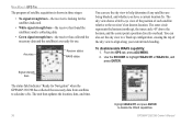
... up configuration, causing the top of each satellite relative to align along your current track heading. From the GPS tab, press ADJ/MENU. 2. The sky view shows a bird's-eye view of the position of the sky view to the receiver's last known location. GPSMAP 292/298 Owner's Manual Signal strength bars The status fi...
... up configuration, causing the top of each satellite relative to align along your current track heading. From the GPS tab, press ADJ/MENU. 2. The sky view shows a bird's-eye view of the position of the sky view to the receiver's last known location. GPSMAP 292/298 Owner's Manual Signal strength bars The status fi...
Owner's Manual
Page 45
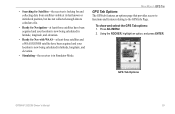
.... • Ready for and collecting data from satellites visible at least three satellites and a WAAS/EGNOS satellite have been acquired and your location is now being calculated in Simulator Mode. To show and select the GPS Tab options: 1. GPS Tab Options GPSMAP 292/298 Owner's Manual 39 • Searching for Satellites-the receiver is in latitude, longitude, and elevation. •...
.... • Ready for and collecting data from satellites visible at least three satellites and a WAAS/EGNOS satellite have been acquired and your location is now being calculated in Simulator Mode. To show and select the GPS Tab options: 1. GPS Tab Options GPSMAP 292/298 Owner's Manual 39 • Searching for Satellites-the receiver is in latitude, longitude, and elevation. •...
Owner's Manual
Page 93
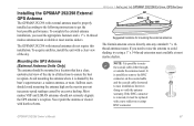
...Garmin antenna screws directly onto any standard 1" x 14thread antenna mount. If you need to raise the antenna to get the best possible performance. GPSMAP 292/298 Owner's Manual 87 It is possible to prevent inaccurate speed readings caused by the boat's superstructure, a radome antenna, or mast. Most marine...doing so voids the antenna warranty. To acquire satellites, install the unit with internal antennas do not require this installation. APPENDIX > INSTALLING THE GPSMAP 292/298 EXTERNAL GPS ANTENNA Suggested locations for mounting the external antenna. If the BNC...
...Garmin antenna screws directly onto any standard 1" x 14thread antenna mount. If you need to raise the antenna to get the best possible performance. GPSMAP 292/298 Owner's Manual 87 It is possible to prevent inaccurate speed readings caused by the boat's superstructure, a radome antenna, or mast. Most marine...doing so voids the antenna warranty. To acquire satellites, install the unit with internal antennas do not require this installation. APPENDIX > INSTALLING THE GPSMAP 292/298 EXTERNAL GPS ANTENNA Suggested locations for mounting the external antenna. If the BNC...
Owner's Manual
Page 101
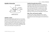
... 45° Satellite Sky View Satellite Location The location of storing orbital data it is highlighted on the location rings. When the bar turns solid, the GPS is being received, and the status of the screen. GPSMAP 292/298 Owner's Manual 95 The gray bar means the GPS is in the selected location format. Date, Time, and Current Location The GPS gets date...
... 45° Satellite Sky View Satellite Location The location of storing orbital data it is highlighted on the location rings. When the bar turns solid, the GPS is being received, and the status of the screen. GPSMAP 292/298 Owner's Manual 95 The gray bar means the GPS is in the selected location format. Date, Time, and Current Location The GPS gets date...
Owner's Manual
Page 102
... http://gps.faa.gov. 96 GPSMAP 292/298 Owner's Manual All SBAS systems use the same receiver frequency; What is just one service provider that broadcast integrity information and differential correction data as EGNOS. Two master stations, located on your Garmin GPS receiver, the receiver automatically... uses the method that are not supported by ground reference stations. In Europe, WAAS is an FAA funded service to less than that monitor GPS satellite data. According to the MOPS...
... http://gps.faa.gov. 96 GPSMAP 292/298 Owner's Manual All SBAS systems use the same receiver frequency; What is just one service provider that broadcast integrity information and differential correction data as EGNOS. Two master stations, located on your Garmin GPS receiver, the receiver automatically... uses the method that are not supported by ground reference stations. In Europe, WAAS is an FAA funded service to less than that monitor GPS satellite data. According to the MOPS...
Owner's Manual
Page 104
... field is active only if a transducer is moving . ETA (Estimate Time of Arrival)-the time you estimate to the GPSMAP 292/298. Leg Dist-the distance between second-by-second position readings. Moving Average Speed-average speed while the unit is connected to ...been moving . GPSMAP 292/298 Owner's Manual Dist to Destination-the distance from a route waypoint to a Go To destination, or the final waypoint in the route. GPS Accuracy-estimated accuracy of the GPS signals and satellite geometry. Leg Fuel-the fuel required to travel from the current location to the next ...
... field is active only if a transducer is moving . ETA (Estimate Time of Arrival)-the time you estimate to the GPSMAP 292/298. Leg Dist-the distance between second-by-second position readings. Moving Average Speed-average speed while the unit is connected to ...been moving . GPSMAP 292/298 Owner's Manual Dist to Destination-the distance from a route waypoint to a Go To destination, or the final waypoint in the route. GPS Accuracy-estimated accuracy of the GPS signals and satellite geometry. Leg Fuel-the fuel required to travel from the current location to the next ...
Owner's Manual
Page 107
...a proximity waypoint. Do not use for the proximity waypoint indicated. Contact your dealer or Garmin Product Support to transfer on data card. Check antenna connections or try moving to transfer ...waypoints can be saved. Simulating Operation-the unit is data to have the unit serviced. GPSMAP 292/298 Owner's Manual 101 No User Waypoints Found, On User Card-see combined defi...the distance. No Proximity Waypoints/Routes/Tracks/User Waypoints Found-attempted to a location with the unit. Proximity Alarm-you used all available proximity waypoints. Shallow Water Alarm-the...
...a proximity waypoint. Do not use for the proximity waypoint indicated. Contact your dealer or Garmin Product Support to transfer on data card. Check antenna connections or try moving to transfer ...waypoints can be saved. Simulating Operation-the unit is data to have the unit serviced. GPSMAP 292/298 Owner's Manual 101 No User Waypoints Found, On User Card-see combined defi...the distance. No Proximity Waypoints/Routes/Tracks/User Waypoints Found-attempted to a location with the unit. Proximity Alarm-you used all available proximity waypoints. Shallow Water Alarm-the...
Owner's Manual
Page 116
.../Off 1 proximity waypoints 50 110 Q Quit Key 5 R receiving a DSC Call 24 replace from card 59 review DSC Call 23 Waypoints 11 Rocker Key 5 routes 17 Copy 51 Create 17 Delete 51 Delete All 51 Routes Tab 51 Route Review Page 52 Options 53 S Satellite Location 95 satellite sky view 95 scroll speed 78 selecting... Scale 64 Temperature Tab 63 thermoclines 83 Tide Tab 40 Time Format 68 Time Tab 68 time zone 68 tools 75 TracBack 14 Activate 16 GPSMAP 292/298 Owner's Manual
.../Off 1 proximity waypoints 50 110 Q Quit Key 5 R receiving a DSC Call 24 replace from card 59 review DSC Call 23 Waypoints 11 Rocker Key 5 routes 17 Copy 51 Create 17 Delete 51 Delete All 51 Routes Tab 51 Route Review Page 52 Options 53 S Satellite Location 95 satellite sky view 95 scroll speed 78 selecting... Scale 64 Temperature Tab 63 thermoclines 83 Tide Tab 40 Time Format 68 Time Tab 68 time zone 68 tools 75 TracBack 14 Activate 16 GPSMAP 292/298 Owner's Manual


