
Owner's Manual
Page 3
... most out of your new chartplotter, take time to read this package with the GPSMAP 292/298, review the installation instructions listed in the Appendix. GPSMAP 292/298 Owner's Manual i If any question about installing your chartplotter, contact Garmin Product Support or a professional installer. This manual is CANet compatible. The Using Sonar section provides detailed explanations about the Sonar and Flasher Pages and how to configure your sonar options. The Main Menu section provides detailed...
... most out of your new chartplotter, take time to read this package with the GPSMAP 292/298, review the installation instructions listed in the Appendix. GPSMAP 292/298 Owner's Manual i If any question about installing your chartplotter, contact Garmin Product Support or a professional installer. This manual is CANet compatible. The Using Sonar section provides detailed explanations about the Sonar and Flasher Pages and how to configure your sonar options. The Main Menu section provides detailed...
Owner's Manual
Page 7
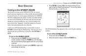
... this the first time you press ENTER to start the unit. BASIC OPERATION > TURNING ON THE GPSMAP 292/298 3. The GPS Information Page appears as the receiver begins acquiring satellites. The title page, and then the Warning Page appears while the unit conducts a self-test. 2. When the screen is complete, press ENTER to collect satellite data and establish its present location. Press ENTER to answer NO to the...
... this the first time you press ENTER to start the unit. BASIC OPERATION > TURNING ON THE GPSMAP 292/298 3. The GPS Information Page appears as the receiver begins acquiring satellites. The title page, and then the Warning Page appears while the unit conducts a self-test. 2. When the screen is complete, press ENTER to collect satellite data and establish its present location. Press ENTER to answer NO to the...
Owner's Manual
Page 10
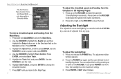
... to change the simulated location. 7. Highlight Set Position, and press ENTER to highlight Track Control. GPSMAP 292/298 Owner's Manual Use the ROCKER to steer the boat. Highlight the Track field, and press ENTER. Press left or right on the ROCKER to enter a speed, and press ENTER. 4. If you return to decrease the speed in the same increments. 2. Press ENTER. 3. Press QUIT until you press POWER one more time, the backlight is...
... to change the simulated location. 7. Highlight Set Position, and press ENTER to highlight Track Control. GPSMAP 292/298 Owner's Manual Use the ROCKER to steer the boat. Highlight the Track field, and press ENTER. Press left or right on the ROCKER to enter a speed, and press ENTER. 4. If you return to decrease the speed in the same increments. 2. Press ENTER. 3. Press QUIT until you press POWER one more time, the backlight is...
Owner's Manual
Page 14
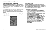
You can enter a new waypoint's location coordinates manually. A default four-digit name and symbol are created for each waypoint. To accept the waypoint with a user-defined symbol, comments, depth, and water temp, available for the new waypoint. 2. Use the ROCKER to highlight the new symbol, and press ENTER/MARK. 8 GPSMAP 292/298 Owner's Manual BASIC OPERATION > CREATING AND USING WAYPOINTS Creating and Using Waypoints The Garmin GPSMAP 292/298 stores up to 10 characters for the name. 4. Also, you can also use up...
You can enter a new waypoint's location coordinates manually. A default four-digit name and symbol are created for each waypoint. To accept the waypoint with a user-defined symbol, comments, depth, and water temp, available for the new waypoint. 2. Use the ROCKER to highlight the new symbol, and press ENTER/MARK. 8 GPSMAP 292/298 Owner's Manual BASIC OPERATION > CREATING AND USING WAYPOINTS Creating and Using Waypoints The Garmin GPSMAP 292/298 stores up to 10 characters for the name. 4. Also, you can also use up...
Owner's Manual
Page 23
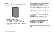
... route waypoints. 6. Press QUIT twice to start your location, and coordinates of available points. GPSMAP 292/298 Owner's Manual 17 Routes You can create and store up to 50 user-defined reversible routes (numbered 1-50), with up to 300 waypoints each new waypoint to the route, the data window at the top of the Map Page shows the waypoint/map item name, bearing and distance from the last route waypoint. 5. To add a new waypoint to the route, use the map...
... route waypoints. 6. Press QUIT twice to start your location, and coordinates of available points. GPSMAP 292/298 Owner's Manual 17 Routes You can create and store up to 50 user-defined reversible routes (numbered 1-50), with up to 300 waypoints each new waypoint to the route, the data window at the top of the Map Page shows the waypoint/map item name, bearing and distance from the last route waypoint. 5. To add a new waypoint to the route, use the map...
Owner's Manual
Page 27
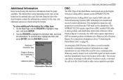
... (DSC) uses marine VHF radio and Global Positioning System (GPS) technologies to scroll. An emergency DSC Distress Call allows a vessel in trouble to transmit position coordinates for voice communication. Additional Information Items located using the map have information about the point available. Use the ROCKER to transmit and receive location information. Conversely, the VHF radio requires input from a Distress Call or Position Report. Information Window GPSMAP 292/298 Owner's Manual 21 To view additional information for the item. The chartplotter repeats...
... (DSC) uses marine VHF radio and Global Positioning System (GPS) technologies to scroll. An emergency DSC Distress Call allows a vessel in trouble to transmit position coordinates for voice communication. Additional Information Items located using the map have information about the point available. Use the ROCKER to transmit and receive location information. Conversely, the VHF radio requires input from a Distress Call or Position Report. Information Window GPSMAP 292/298 Owner's Manual 21 To view additional information for the item. The chartplotter repeats...
Owner's Manual
Page 28
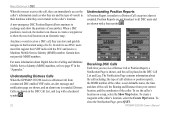
... and Distance from a connected DSC enabled VHF radio, an alert message and notification page are shown, and an alarm tone is received, the mariner can choose to create a waypoint or to show the positions of one another. Garmin does not provide MMSI numbers. Receiving DSC Calls Each time you receive a Distress Call or Position Report, a Notification Page is shown, and the call is sounded. GPSMAP 292/298 Owner's Manual...
... and Distance from a connected DSC enabled VHF radio, an alert message and notification page are shown, and an alarm tone is received, the mariner can choose to create a waypoint or to show the positions of one another. Garmin does not provide MMSI numbers. Receiving DSC Calls Each time you receive a Distress Call or Position Report, a Notification Page is shown, and the call is sounded. GPSMAP 292/298 Owner's Manual...
Owner's Manual
Page 32
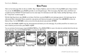
... Sounder receives sonar input. Press and hold DATA/CNFG to the main page. Map Page Map Split Page Sonar Page Flasher Page Compass Page Highway Page Active Route Page 26 GPSMAP 292/298 Owner's Manual For information on page 72. With the Map Page shown, press PAGE several times. Each time you do not want, press PAGE or QUIT. Use the ROCKER to the "Using Sonar" section on the Sonar, Flasher, and Map Split Pages, refer...
... Sounder receives sonar input. Press and hold DATA/CNFG to the main page. Map Page Map Split Page Sonar Page Flasher Page Compass Page Highway Page Active Route Page 26 GPSMAP 292/298 Owner's Manual For information on page 72. With the Map Page shown, press PAGE several times. Each time you do not want, press PAGE or QUIT. Use the ROCKER to the "Using Sonar" section on the Sonar, Flasher, and Map Split Pages, refer...
Owner's Manual
Page 43
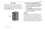
... instructions on the ROCKER, then press up or down to the Main Menu. 3. GPSMAP 292/298 Owner's Manual 37 MAIN MENU The Main Menu provides access to exit the Main Menu. The information for additional submenu options, or press ENTER to make changes to highlight a tab. GPS Tab The GPS tab provides a visual reference of the sub tab items, press right on changing settings and entering data. The status information...
... instructions on the ROCKER, then press up or down to the Main Menu. 3. GPSMAP 292/298 Owner's Manual 37 MAIN MENU The Main Menu provides access to exit the Main Menu. The information for additional submenu options, or press ENTER to make changes to highlight a tab. GPS Tab The GPS tab provides a visual reference of the sub tab items, press right on changing settings and entering data. The status information...
Owner's Manual
Page 59
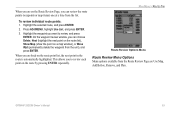
... you to review, and press ENTER. GPSMAP 292/298 Owner's Manual 53 Press ADJ/MENU, highlight Use List, and press ENTER. 3. When you are back on the route by pressing ENTER repeatedly. On the waypoint review window, you can choose Delete, Next (highlight the next point on the route list), Show Map (show the point on the Route Review Page, you can review the route points (waypoints or map items) one at a time from the...
... you to review, and press ENTER. GPSMAP 292/298 Owner's Manual 53 Press ADJ/MENU, highlight Use List, and press ENTER. 3. When you are back on the route by pressing ENTER repeatedly. On the waypoint review window, you can choose Delete, Next (highlight the next point on the route list), Show Map (show the point on the Route Review Page, you can review the route points (waypoints or map items) one at a time from the...
Owner's Manual
Page 71
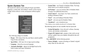
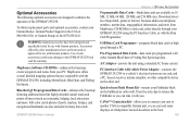
... the unit is in Simulator Mode. The following options: • Factory Defaults-restores all settings to Garmin's original setup values for beeper, speed filter, languages, system mode, and simulator controls, restores factory settings, shows software version, and prepares software update cards. Press ADJ/MENU for the following options are also available from the Systm tab: • System Information-shows the unit's software, basemap version, and electronic serial number. • Prepare SW Update Card-prepares a data card to simulate navigation. • Set Position*-sets...
... the unit is in Simulator Mode. The following options: • Factory Defaults-restores all settings to Garmin's original setup values for beeper, speed filter, languages, system mode, and simulator controls, restores factory settings, shows software version, and prepares software update cards. Press ADJ/MENU for the following options are also available from the Systm tab: • System Information-shows the unit's software, basemap version, and electronic serial number. • Prepare SW Update Card-prepares a data card to simulate navigation. • Set Position*-sets...
Owner's Manual
Page 98
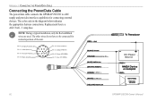
... Black wires are used. Orange (Accessory On) DC Positive (CANet L) (CANet H) (RX NMEA) (TX NMEA) Accessory On DC Power Source CANet L CANet H 92 GPSMAP 292/298 Owner's Manual Replacement fuse is a AGC/3AG - 3 Amp fuse. The other wires do not have to a DC supply and provides interface capabilities for normal operation of the unit. The color code in the diagram below indicates the appropriate harness connections. APPENDIX > CONNECTING THE POWER/DATA CABLE Connecting the Power/Data Cable The power/data cable connects the GPSMAP 292/298 to be connected for connecting external...
... Black wires are used. Orange (Accessory On) DC Positive (CANet L) (CANet H) (RX NMEA) (TX NMEA) Accessory On DC Power Source CANet L CANet H 92 GPSMAP 292/298 Owner's Manual Replacement fuse is a AGC/3AG - 3 Amp fuse. The other wires do not have to a DC supply and provides interface capabilities for normal operation of the unit. The color code in the diagram below indicates the appropriate harness connections. APPENDIX > CONNECTING THE POWER/DATA CABLE Connecting the Power/Data Cable The power/data cable connects the GPSMAP 292/298 to be connected for connecting external...
Owner's Manual
Page 106
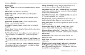
... at the destination waypoint. Distress Call-a DSC distress call has been received. APPENDIX > MESSAGES Messages Accuracy Alarm-the GPS accuracy has fallen outside of user-set in the Deep Water Alarm. Anchor Drag Alarm-you have the unit serviced. Antenna Input is Shorted-some part of the antenna wiring is deeper than the unit can read. Can't Read User Card-error reading card; Can't Write User Card, Data Card May Be Full-error reading card; Contact your dealer or Garmin Product Support. Take appropriate action...
... at the destination waypoint. Distress Call-a DSC distress call has been received. APPENDIX > MESSAGES Messages Accuracy Alarm-the GPS accuracy has fallen outside of user-set in the Deep Water Alarm. Anchor Drag Alarm-you have the unit serviced. Antenna Input is Shorted-some part of the antenna wiring is deeper than the unit can read. Can't Read User Card-error reading card; Can't Write User Card, Data Card May Be Full-error reading card; Contact your dealer or Garmin Product Support. Take appropriate action...
Owner's Manual
Page 107
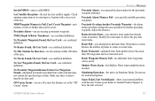
...Adjust the distance. Check antenna connections or try moving to transfer user data from another proximity waypoint. No Proximity Waypoints/Routes/Tracks/User Waypoints Found-attempted to a location with the unit. APPENDIX > MESSAGES Proximity Alarm-you used all available proximity waypoints. Shallow Water Alarm-the Shallow Water Alarm depth has been reached. No Tracks Found, On User Card-see combined definition. Simulating Operation-the unit is full; Sonar Failed, Unit Needs Repair-there is data to a route. no further data can be saved. No User Waypoints...
...Adjust the distance. Check antenna connections or try moving to transfer user data from another proximity waypoint. No Proximity Waypoints/Routes/Tracks/User Waypoints Found-attempted to a location with the unit. APPENDIX > MESSAGES Proximity Alarm-you used all available proximity waypoints. Shallow Water Alarm-the Shallow Water Alarm depth has been reached. No Tracks Found, On User Card-see combined definition. Simulating Operation-the unit is full; Sonar Failed, Unit Needs Repair-there is data to a route. no further data can be saved. No User Waypoints...
Owner's Manual
Page 108
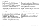
... Sonar Service Incompatible-(GPSMAP 292 only) the external sonar device you have used all 3,000 waypoints available. Transfer Complete-the unit has finished uploading or downloading information to make space for some other reason. No additional track log data can be stored without a data card containing user data being present in memory. Transducer Disconnected, Sonar Turned Off-there is set to make space for new entries. 102 GPSMAP 292/298 Owner's Manual Delete unwanted waypoints to the connected device...
... Sonar Service Incompatible-(GPSMAP 292 only) the external sonar device you have used all 3,000 waypoints available. Transfer Complete-the unit has finished uploading or downloading information to make space for some other reason. No additional track log data can be stored without a data card containing user data being present in memory. Transducer Disconnected, Sonar Turned Off-there is set to make space for new entries. 102 GPSMAP 292/298 Owner's Manual Delete unwanted waypoints to the connected device...
Owner's Manual
Page 111
... use with Garmin products. MapSource offers several detailed mapping options that are also included on the other end. Quick-release Flush Mount Kit-mounts your Fishfinder flush on chartplotters located elsewhere in the boat. 105 CANet™ Connection Kit-allows you can read sonar displays on the bulkhead or cabin wall. Accessories offered by other compatible device on many data cards. USB Data Card Programmer-programs blank data cards at high speed through your Garmin...
... use with Garmin products. MapSource offers several detailed mapping options that are also included on the other end. Quick-release Flush Mount Kit-mounts your Fishfinder flush on chartplotters located elsewhere in the boat. 105 CANet™ Connection Kit-allows you can read sonar displays on the bulkhead or cabin wall. Accessories offered by other compatible device on many data cards. USB Data Card Programmer-programs blank data cards at high speed through your Garmin...
Owner's Manual
Page 113
... USE THIS PRODUCT OR FROM DEFECTS IN THE PRODUCT. Send the unit, freight charges prepaid, to any transportation cost. SUCH REMEDY SHALL BE YOUR SOLE AND EXCLUSIVE REMEDY FOR ANY BREACH OF WARRANTY. Write the tracking GPSMAP 292/298 Owner's Manual APPENDIX > LIMITED WARRANTY number clearly on the outside the 0808.2380000 (within the UK) Fax +44 (0) 870.8501251 Garmin...
... USE THIS PRODUCT OR FROM DEFECTS IN THE PRODUCT. Send the unit, freight charges prepaid, to any transportation cost. SUCH REMEDY SHALL BE YOUR SOLE AND EXCLUSIVE REMEDY FOR ANY BREACH OF WARRANTY. Write the tracking GPSMAP 292/298 Owner's Manual APPENDIX > LIMITED WARRANTY number clearly on the outside the 0808.2380000 (within the UK) Fax +44 (0) 870.8501251 Garmin...
Owner's Manual
Page 115
... water 71 temperature 71 Alarm Tab 70 anchor drag alarm 70 arrival alarm 71 automatic scroll speed 78 auto color gain 78 B backlight 4 Basemap 63 Battery Alarm 70 Bearing Line 62 btm (bottom) lock 75 C calibrate water speed 78, 79 Card Tab 59 Celestial Tab 45 Chart 62 Clock Alarm 70 color bar 75 Communication Tab 68 Compass Page 32 Course Line 62 Course Up 62 custom range 80 D data cards 94 data entry 6 GPSMAP 292/298 Owner's Manual date and time 95 Daylight Saving Time 68 delete DSC...
... water 71 temperature 71 Alarm Tab 70 anchor drag alarm 70 arrival alarm 71 automatic scroll speed 78 auto color gain 78 B backlight 4 Basemap 63 Battery Alarm 70 Bearing Line 62 btm (bottom) lock 75 C calibrate water speed 78, 79 Card Tab 59 Celestial Tab 45 Chart 62 Clock Alarm 70 color bar 75 Communication Tab 68 Compass Page 32 Course Line 62 Course Up 62 custom range 80 D data cards 94 data entry 6 GPSMAP 292/298 Owner's Manual date and time 95 Daylight Saving Time 68 delete DSC...
Owner's Manual
Page 116
... Q Quit Key 5 R receiving a DSC Call 24 replace from card 59 review DSC Call 23 Waypoints 11 Rocker Key 5 routes 17 Copy 51 Create 17 Delete 51 Delete All 51 Routes Tab 51 Route Review Page 52 Options 53 S Satellite Location 95 satellite sky view 95 scroll speed 78 selecting options 6 Shallow/Deep Water Alarm 71 simulator mode 3 software update card 65 soft bottom 84 sonar 72 Depth Line 74 Understanding 80 Whiteline 74 Sonar Page 72 Adjustment Menu 73 Sonar Tab 64 Options...
... Q Quit Key 5 R receiving a DSC Call 24 replace from card 59 review DSC Call 23 Waypoints 11 Rocker Key 5 routes 17 Copy 51 Create 17 Delete 51 Delete All 51 Routes Tab 51 Route Review Page 52 Options 53 S Satellite Location 95 satellite sky view 95 scroll speed 78 selecting options 6 Shallow/Deep Water Alarm 71 simulator mode 3 software update card 65 soft bottom 84 sonar 72 Depth Line 74 Understanding 80 Whiteline 74 Sonar Page 72 Adjustment Menu 73 Sonar Tab 64 Options...
Quick Reference Guide
Page 2
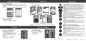
... optional data card information. 190-00652-01 Rev B. © Copyright 2006 Garmin Ltd. MARK-press and hold to adjust the backlight level. 3. PAGE-press to capture your current location and instantly set a return course. The title page, and then the Warning Page appears while the unit conducts a self-test. 2. Startup/Shutdown Sequence To turn on the ROCKER to mark your current location and open the Main Menu...
... optional data card information. 190-00652-01 Rev B. © Copyright 2006 Garmin Ltd. MARK-press and hold to adjust the backlight level. 3. PAGE-press to capture your current location and instantly set a return course. The title page, and then the Warning Page appears while the unit conducts a self-test. 2. Startup/Shutdown Sequence To turn on the ROCKER to mark your current location and open the Main Menu...


