
Declaration of Conformity
Page 1
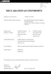
...: 15/12/2005 Revised: Page: 1 of 1 DECLARATION of CONFORMITY Application of Equipment: Model Number(s): GARMIN International & GARMIN Corporation 1200 E. 151st Street No.68, Jangshu 2nd Rd., Olathe, Kansas 66062 Shijr, Taipei County, U.S.A TAIWAN, R.O.C. Marine Navigation Equipment (Global Positioning System Receiver) GPSMAP 292 GPSMAP 298 The undersigned does hereby declare that the equipment complies to which Conformity is...
...: 15/12/2005 Revised: Page: 1 of 1 DECLARATION of CONFORMITY Application of Equipment: Model Number(s): GARMIN International & GARMIN Corporation 1200 E. 151st Street No.68, Jangshu 2nd Rd., Olathe, Kansas 66062 Shijr, Taipei County, U.S.A TAIWAN, R.O.C. Marine Navigation Equipment (Global Positioning System Receiver) GPSMAP 292 GPSMAP 298 The undersigned does hereby declare that the equipment complies to which Conformity is...
Owner's Manual
Page 6
... displayed to the consumer. See www.garmin.com/prop65 for more information. We use of authorized government charts. In some inaccurate or incomplete data. When navigating, carefully compare information displayed on the GPSMAP 292/298 to all data sources contain some...Garmin is to provide customers with California's Proposition 65. Official government charts and notices to mariners contain all information needed to cause cancer, birth defects, or reproductive harm. Important Information MAP DATA INFORMATION: One of the goals of California to navigate safely. iv GPSMAP 292...
... displayed to the consumer. See www.garmin.com/prop65 for more information. We use of authorized government charts. In some inaccurate or incomplete data. When navigating, carefully compare information displayed on the GPSMAP 292/298 to all data sources contain some...Garmin is to provide customers with California's Proposition 65. Official government charts and notices to mariners contain all information needed to cause cancer, birth defects, or reproductive harm. Important Information MAP DATA INFORMATION: One of the goals of California to navigate safely. iv GPSMAP 292...
Owner's Manual
Page 27
... a GPS to transmit position coordinates for a Map item: 1. To scroll the text, highlight the field, and press ENTER. The information varies depending on the type of data loaded on the GPSMAP 292/298. On the Map Page, use the ROCKER to transmit and receive location ...DSC Page of information in a single transmission or call properties received from a DSC enabled VHF radio to the Coast Guard or other rescue operation specialist. Digital Selective Calling (DSC) uses marine VHF radio and Global Positioning System (GPS) technologies to highlight a map item, and press ENTER....
... a GPS to transmit position coordinates for a Map item: 1. To scroll the text, highlight the field, and press ENTER. The information varies depending on the type of data loaded on the GPSMAP 292/298. On the Map Page, use the ROCKER to transmit and receive location ...DSC Page of information in a single transmission or call properties received from a DSC enabled VHF radio to the Coast Guard or other rescue operation specialist. Digital Selective Calling (DSC) uses marine VHF radio and Global Positioning System (GPS) technologies to highlight a map item, and press ENTER....
Owner's Manual
Page 28
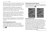
...Go To. To see the caller's location on an electronic map. GPSMAP 292/298 Owner's Manual Understanding Distress Calls When the GPSMAP 292/298 receives a Distress Call from your current location, and the coordinates of the caller. Garmin does not provide MMSI numbers. For more information about the call including...Position Reports are not broadcast to the caller's location. In order to show the positions of one another. When a DSC position is received, the mariner can choose to create a waypoint or to use DSC, users must first register their database while they are shown, and ...
...Go To. To see the caller's location on an electronic map. GPSMAP 292/298 Owner's Manual Understanding Distress Calls When the GPSMAP 292/298 receives a Distress Call from your current location, and the coordinates of the caller. Garmin does not provide MMSI numbers. For more information about the call including...Position Reports are not broadcast to the caller's location. In order to show the positions of one another. When a DSC position is received, the mariner can choose to create a waypoint or to use DSC, users must first register their database while they are shown, and ...
Owner's Manual
Page 65
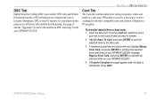
... and receive location information. MAIN MENU > DSC AND CARD TAB Card Tab The Card tab contains options for more information on your GPSMAP 292/298. Press QUIT. Highlight Replace From Card, and press ENTER to a data card, it with other compatible units and Garmin's MapSource...Insert the data card. A Transfer Complete message appears after the data is used by mariners to a data card. DSC is transferred. DSC Tab Digital Selective Calling (DSC) uses marine VHF radio and Global Positioning System (GPS) technologies to the data card. 3. GPSMAP 292/298 Owner's Manual 59
... and receive location information. MAIN MENU > DSC AND CARD TAB Card Tab The Card tab contains options for more information on your GPSMAP 292/298. Press QUIT. Highlight Replace From Card, and press ENTER to a data card, it with other compatible units and Garmin's MapSource...Insert the data card. A Transfer Complete message appears after the data is used by mariners to a data card. DSC is transferred. DSC Tab Digital Selective Calling (DSC) uses marine VHF radio and Global Positioning System (GPS) technologies to the data card. 3. GPSMAP 292/298 Owner's Manual 59
Owner's Manual
Page 93
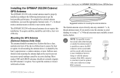
Installing the GPSMAP 292/298 External GPS Antenna The GPSMAP 292/298 with external antenna must be mounted in all directions to avoid shading, try using a 1" x 14-thread extension mast available at most marine dealers. To complete the external antenna installation, you need the appropriate fasteners and a 1" x 14-thread marine antenna mount available at most marine dealers. Sailboat users...
Installing the GPSMAP 292/298 External GPS Antenna The GPSMAP 292/298 with external antenna must be mounted in all directions to avoid shading, try using a 1" x 14-thread extension mast available at most marine dealers. To complete the external antenna installation, you need the appropriate fasteners and a 1" x 14-thread marine antenna mount available at most marine dealers. Sailboat users...
Owner's Manual
Page 97
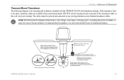
...water from your warranty. Apply marine sealant to all screw threads to any part of the prop. The transducer can cause cavitation that creates air bubbles or causes the water to become turbulent. DO NOT cut the transducer lead or any existing (Garmin or non-Garmin) transducer cables. NOTE: ... in clean (non-turbulent) water for mounting the transducer included with the GPSMAP 292/298 with the bottom. If the transducer lead is in the path of the transducer cable, as this will void your Garmin dealer. It is important that the transducer is below aluminum hull Make sure...
...water from your warranty. Apply marine sealant to all screw threads to any part of the prop. The transducer can cause cavitation that creates air bubbles or causes the water to become turbulent. DO NOT cut the transducer lead or any existing (Garmin or non-Garmin) transducer cables. NOTE: ... in clean (non-turbulent) water for mounting the transducer included with the GPSMAP 292/298 with the bottom. If the transducer lead is in the path of the transducer cable, as this will void your Garmin dealer. It is important that the transducer is below aluminum hull Make sure...
Owner's Manual
Page 100
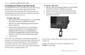
APPENDIX > INSTALLING AND REMOVING DATA CARDS Installing and Removing Data Cards The GPSMAP 292/298 uses optional Garmin marine BlueChart g2 and MapSource data cards to read , a summary screen appears. Data cards are not waterproof and should be installed or removed at the ... case supplied with the label facing front and the handle bottom, into the unit. Data cards can be stored in not necessary to acknowledge. 94 GPSMAP 292/298 Owner's Manual Firmly push the card into the slot. 3. Data cards should not be exposed to moisture or excessive static charges. To remove a...
APPENDIX > INSTALLING AND REMOVING DATA CARDS Installing and Removing Data Cards The GPSMAP 292/298 uses optional Garmin marine BlueChart g2 and MapSource data cards to read , a summary screen appears. Data cards are not waterproof and should be installed or removed at the ... case supplied with the label facing front and the handle bottom, into the unit. Data cards can be stored in not necessary to acknowledge. 94 GPSMAP 292/298 Owner's Manual Firmly push the card into the slot. 3. Data cards should not be exposed to moisture or excessive static charges. To remove a...
Owner's Manual
Page 103
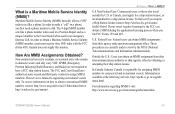
...only. For information regarding MMSI's visit: http://www.navcen.uscg.gov/marcomms/gmdss/mmsi.htm. GPSMAP 292/298 Owner's Manual 97 The 9-digit MMSI number acts like a phone. Non-commercial users...Canada is a Maritime Mobile Service Identity (MMSI)? To receive information on a phone, you require a Ship Station license contact: http://wireless.fcc.gov/marine/ fctsht14.html. APPENDIX > WHAT IS MMSI? U.S ...number, contact: http://www.uscg.mil/rescue21/links/mmsi.htm or http://wireless.fcc.gov/marine/. Garmin does not supply this number. The FCC and Coast Guard have a FCC ship station license...
...only. For information regarding MMSI's visit: http://www.navcen.uscg.gov/marcomms/gmdss/mmsi.htm. GPSMAP 292/298 Owner's Manual 97 The 9-digit MMSI number acts like a phone. Non-commercial users...Canada is a Maritime Mobile Service Identity (MMSI)? To receive information on a phone, you require a Ship Station license contact: http://wireless.fcc.gov/marine/ fctsht14.html. APPENDIX > WHAT IS MMSI? U.S ...number, contact: http://www.uscg.mil/rescue21/links/mmsi.htm or http://wireless.fcc.gov/marine/. Garmin does not supply this number. The FCC and Coast Guard have a FCC ship station license...
Owner's Manual
Page 109
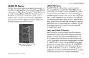
... transition from using LORAN to the location stored in memory. 103 The GPSMAP 292/298 unit automatically converts GPS coordinates to LORAN TDs for navigation, it always references the LORAN chain number... show your position as a TD or enter waypoints as if the unit was actually receiving LORAN signals. Position coordinates can be used for ocean and coastal navigation. When the unit... used for inland navigation by the United States Coast Guard. From the perspective of a mariner, the system is approximately 30 meters. You can show as TDs, and all navigation ...
... transition from using LORAN to the location stored in memory. 103 The GPSMAP 292/298 unit automatically converts GPS coordinates to LORAN TDs for navigation, it always references the LORAN chain number... show your position as a TD or enter waypoints as if the unit was actually receiving LORAN signals. Position coordinates can be used for ocean and coastal navigation. When the unit... used for inland navigation by the United States Coast Guard. From the perspective of a mariner, the system is approximately 30 meters. You can show as TDs, and all navigation ...
Owner's Manual
Page 111
... to a data card, either Garmin BlueChart or Fishing Hot Spots map data. PC Interface Cable with vehicle Power Adapter-connects the GPSMAP 292/298 to enhance the operation of the GPSMAP 292/298. Optional Accessories The following optional accessories are designed to a vehicle's electrical system on one end, and a PC, beacon receiver, marine autopilot, or other compatible...
... to a data card, either Garmin BlueChart or Fishing Hot Spots map data. PC Interface Cable with vehicle Power Adapter-connects the GPSMAP 292/298 to enhance the operation of the GPSMAP 292/298. Optional Accessories The following optional accessories are designed to a vehicle's electrical system on one end, and a PC, beacon receiver, marine autopilot, or other compatible...


