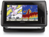
Garmin GPSMAP 741xs Support Question
Garmin GPSMAP 741xs Support Question
Find answers below for this question about Garmin GPSMAP 741xs.Need a Garmin GPSMAP 741xs manual? We have 7 online manuals for this item!
Question posted by Curthupp on May 27th, 2017
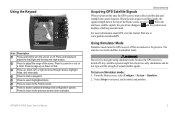
How Do I Go Into Simulation Mode On A Garmin Marine Gps Modle741xs
Current Answers
Answer #1: Posted by hitesh1531 on June 4th, 2017 1:59 AM

Member since:
June 3rd, 2017 Points: 9,240

Note that this mode is not always called simulation mode on the different models. On the etrex it is called "demo mode" or "gps off" while the emap calls it "Use Indoors" on the local menu or "gps off" on the setup menu.
On most units you can turn on simulation mode from the main menu. This is done by selecting "System Setup" and toggle the mode entry from "normal" or "battery/power save" to "simulation" mode. Some units have "system setup" as a submenu choice of "setup". On the G-III family and some etrex models this is also available from the local menu on the satellite status page. This information is only remembered for this power on cycle and the unit will revert to its previous mode automatically after you turn it off. Of course you can also modify this mode manually at any time during this session.
Strange as it may sound there is some navigation features on some of the Garmin handhelds that can be used in simulation mode. In particular any of the newer units support a screen that shows the sun and moon positions. This can be used as a crude compass to determine North and can be quite effective under conditions where you can't get a fix or need to conserve batteries. For rough estimates hold the unit in front of you with North straight ahead and then rotate you body until the sun or moon in the display is approximately where it really is in the sky. You are now facing North. For more accuracy lay the unit on the ground and use a straw placed vertically along the edge of the unit to cast a shadow over the face. Align the unit so that the edge of the shadow from the straw splits the sun and hits the dot in the center of the circle. Now the front of the unit is facing North. Note that this is true north.
The Vista and Summit contain a built in compass and altimeter. These are certainly useful for navigation use even without the standard gps features. Note that "demo mode" cannot be used for this since the compass is disabled in this mode but "gps off" will work fine. If you have a topo map available in the unit you can use the altimeter to help determine your location relative to the map features and topo data and then the "New Location" setting on the status sceen can be used to move your apparent position to the location on the map that you have determined. Then the waypoints you have saved and the maps that are loaded can be used to plan your trip or guide you out of an area where there is no gps coverage. Of course, the compass and altimeter are useful with a paper map as well.
Related Garmin GPSMAP 741xs Manual Pages

Similar Questions


Depth has been working since installed. Now blank. Is there an on off control for this that may have...