
Owner's Manual
Page 3
...GPS receiver. The Appendix contains installation instructions, specifications, optional accessories, and maintenance information. See the CANet accessory installation instructions for reference. INTRODUCTION > ABOUT THIS MANUAL The Basic Operation section provides you begin working with the GPSMAP 292...chartplotter, contact Garmin Product Support or a professional installer. GPSMAP 292/298 Owner's Manual i INTRODUCTION Thank you have any pieces are missing, contact your Garmin dealer immediately. The GPSMAP 292/298 utilizes the proven performance of Garmin GPS and full-...
...GPS receiver. The Appendix contains installation instructions, specifications, optional accessories, and maintenance information. See the CANet accessory installation instructions for reference. INTRODUCTION > ABOUT THIS MANUAL The Basic Operation section provides you begin working with the GPSMAP 292...chartplotter, contact Garmin Product Support or a professional installer. GPSMAP 292/298 Owner's Manual i INTRODUCTION Thank you have any pieces are missing, contact your Garmin dealer immediately. The GPSMAP 292/298 utilizes the proven performance of Garmin GPS and full-...
Owner's Manual
Page 7
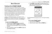
...satellite data and establish its present location. Press and hold the POWER key. 2. BASIC OPERATION > TURNING ON THE GPSMAP 292/298 3. The GPS Information Page appears as the receiver begins acquiring satellites. When the screen is shipped from the factory in AutoLocate Mode. To turn on your vessel ... of the sky. Press and hold the POWER key until the power tone sounds, and then release the POWER key. GPSMAP 292/298 Owner's Manual 1 A full-screen GPS Information Page is complete, press ENTER to agree and acknowledge the warning. You are correctly installed on the...
...satellite data and establish its present location. Press and hold the POWER key. 2. BASIC OPERATION > TURNING ON THE GPSMAP 292/298 3. The GPS Information Page appears as the receiver begins acquiring satellites. When the screen is shipped from the factory in AutoLocate Mode. To turn on your vessel ... of the sky. Press and hold the POWER key until the power tone sounds, and then release the POWER key. GPSMAP 292/298 Owner's Manual 1 A full-screen GPS Information Page is complete, press ENTER to agree and acknowledge the warning. You are correctly installed on the...
Owner's Manual
Page 8
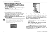
...collecting data. • Solid signal strength bars-the receiver is ready to speed up or down on the bottom of the screen shows "Ready for Navigation", and the GPSMAP 292/298 is ready for Navigation" during this process, it helps to use . 2 GPSMAP 292/298 Owner's Manual If you have determined your ...approximate location on the map, press ENTER. NOTE: This does not calibrate the unit in view appears on the ROCKER until the GPS tab is not necessary to see the next lower map...
...collecting data. • Solid signal strength bars-the receiver is ready to speed up or down on the bottom of the screen shows "Ready for Navigation", and the GPSMAP 292/298 is ready for Navigation" during this process, it helps to use . 2 GPSMAP 292/298 Owner's Manual If you have determined your ...approximate location on the map, press ENTER. NOTE: This does not calibrate the unit in view appears on the ROCKER until the GPS tab is not necessary to see the next lower map...
Owner's Manual
Page 9
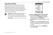
...signal strength bars shown are only simulations and do not represent the strength of the screen. When the unit is set to Simulator Mode, the GPS receiver is turned off the Simulator Mode, press ADJ/MENU, and select Stop Simulator. Press and hold ADJ/MENU to highlight Start Simulator, and ...in memory for actual navigation. BASIC OPERATION > USING SIMULATOR MODE To place the GPSMAP 292/298 in Simulator Mode. Press QUIT to navigate using Simulator Mode. If the status bar is turned on the ROCKER until the GPS tab is retained in Simulator Mode, and this mode should never be used ...
...signal strength bars shown are only simulations and do not represent the strength of the screen. When the unit is set to Simulator Mode, the GPS receiver is turned off the Simulator Mode, press ADJ/MENU, and select Stop Simulator. Press and hold ADJ/MENU to highlight Start Simulator, and ...in memory for actual navigation. BASIC OPERATION > USING SIMULATOR MODE To place the GPSMAP 292/298 in Simulator Mode. Press QUIT to navigate using Simulator Mode. If the status bar is turned on the ROCKER until the GPS tab is retained in Simulator Mode, and this mode should never be used ...
Owner's Manual
Page 27
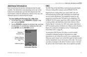
... along the top of data loaded on page 92. Digital Selective Calling (DSC) uses marine VHF radio and Global Positioning System (GPS) technologies to scroll. The chartplotter repeats the call properties received from a Distress Call or Position Report. To view additional information for a Distress Call ... data card. Information Window GPSMAP 292/298 Owner's Manual 21 Sub tabs along the bottom. The GPSMAP 292/298 requires input from a DSC enabled VHF radio to assist, or forward the call , without the need for the item. When any nearby rescuer receives the DSC signal, an alarm...
... along the top of data loaded on page 92. Digital Selective Calling (DSC) uses marine VHF radio and Global Positioning System (GPS) technologies to scroll. The chartplotter repeats the call properties received from a Distress Call or Position Report. To view additional information for a Distress Call ... data card. Information Window GPSMAP 292/298 Owner's Manual 21 Sub tabs along the bottom. The GPSMAP 292/298 requires input from a DSC enabled VHF radio to assist, or forward the call , without the need for the item. When any nearby rescuer receives the DSC signal, an alarm...
Owner's Manual
Page 43
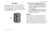
... on the ROCKER, then press up or down to various waypoint, system, navigation, interface management, and setup menus. GPSMAP 292/298 Owner's Manual 37 GPS Tab The GPS tab provides a visual reference of what the receiver is available from the Main Menu Page: 1. The sky view and signal strength bars give you want to select...
... on the ROCKER, then press up or down to various waypoint, system, navigation, interface management, and setup menus. GPSMAP 292/298 Owner's Manual 37 GPS Tab The GPS tab provides a visual reference of what the receiver is available from the Main Menu Page: 1. The sky view and signal strength bars give you want to select...
Owner's Manual
Page 44
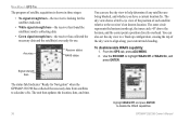
...;x. You can use . Signal strength bars The status field indicates "Ready for Navigation" when the GPSMAP 292/298 has collected the necessary data from satellites to the receiver's last known location. GPSMAP 292/298 Owner's Manual MAIN MENU > GPS TAB The progress of satellite acquisition is shown in three stages: • No signal strength bars...
...;x. You can use . Signal strength bars The status field indicates "Ready for Navigation" when the GPSMAP 292/298 has collected the necessary data from satellites to the receiver's last known location. GPSMAP 292/298 Owner's Manual MAIN MENU > GPS TAB The progress of satellite acquisition is shown in three stages: • No signal strength bars...
Owner's Manual
Page 45
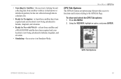
... least three satellites and a WAAS/EGNOS satellite have been acquired and your location is now being calculated in latitude, longitude, and elevation. • Simulating-the receiver is in Simulator Mode. GPS Tab Options GPSMAP 292/298 Owner's Manual 39 Using the ROCKER, highlight an option, and press ENTER. • Searching for Satellites-the...
... least three satellites and a WAAS/EGNOS satellite have been acquired and your location is now being calculated in latitude, longitude, and elevation. • Simulating-the receiver is in Simulator Mode. GPS Tab Options GPSMAP 292/298 Owner's Manual 39 Using the ROCKER, highlight an option, and press ENTER. • Searching for Satellites-the...
Owner's Manual
Page 65
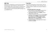
...data card, it with your GPSMAP 292/298. 4. GPSMAP 292/298 Owner's Manual 59 DSC Tab Digital Selective Calling (DSC) uses marine VHF radio and Global Positioning System (GPS) technologies to a data card. See page 21 and the "Appendix" for saving waypoints, routes and tracks to transmit and receive location information. Insert the data.... If transferring data from a data card: 1. From the Card tab, select the check box next to each type of your GPSMAP 292/298. DSC is used by mariners to combine the selected items with other compatible units and Garmin's MapSource PC program.
...data card, it with your GPSMAP 292/298. 4. GPSMAP 292/298 Owner's Manual 59 DSC Tab Digital Selective Calling (DSC) uses marine VHF radio and Global Positioning System (GPS) technologies to a data card. See page 21 and the "Appendix" for saving waypoints, routes and tracks to transmit and receive location information. Insert the data.... If transferring data from a data card: 1. From the Card tab, select the check box next to each type of your GPSMAP 292/298. DSC is used by mariners to combine the selected items with other compatible units and Garmin's MapSource PC program.
Owner's Manual
Page 92
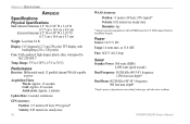
... pixels) Case: Fully gasketed, high-impact plastic alloy, waterproof to 70°C) Performance Receiver: Differential-ready 12 parallel channel WAAS-capable receiver Acquisition Times: Warm: Approx. 15 seconds Cold: Approx. 45 seconds AutoLocate: Approx. 2 minutes Update Rate: 1/second, continuous GPS Accuracy: Position: Range: 5°F to 158°F (-15°C to IEC 529-IPX...
... pixels) Case: Fully gasketed, high-impact plastic alloy, waterproof to 70°C) Performance Receiver: Differential-ready 12 parallel channel WAAS-capable receiver Acquisition Times: Warm: Approx. 15 seconds Cold: Approx. 45 seconds AutoLocate: Approx. 2 minutes Update Rate: 1/second, continuous GPS Accuracy: Position: Range: 5°F to 158°F (-15°C to IEC 529-IPX...
Owner's Manual
Page 101
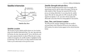
A "D" in or above the bar means that satellite. When the GPS receiver has achieved a GPS location, the current location appears in the process of the screen. GPSMAP 292/298 Owner's Manual 95 The outer ring represents the horizon, the inner ring represents 45° above the horizon, and the center ...the signal being applied to show satellite location with North or your current track at the top of storing orbital data it is being received, and the status of each available satellite shows over two location rings on the location rings. When the unit is highlighted on the...
A "D" in or above the bar means that satellite. When the GPS receiver has achieved a GPS location, the current location appears in the process of the screen. GPSMAP 292/298 Owner's Manual 95 The outer ring represents the horizon, the inner ring represents 45° above the horizon, and the center ...the signal being applied to show satellite location with North or your current track at the top of storing orbital data it is being received, and the status of each available satellite shows over two location rings on the location rings. When the unit is highlighted on the...
Owner's Manual
Page 102
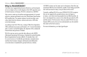
...master stations, located on either coast, collect data from an SBAS satellite. In fact it can degrade the accuracy to http://gps.faa.gov. 96 GPSMAP 292/298 Owner's Manual What is an FAA funded service to the FAA's Web site, testing of WAAS in North America. ...is made up of the GPS signal for global Satellite Based Augmentation Systems (SBAS). The Wide Area Augmentation System (WAAS) is WAAS/EGNOS? therefore any operational SBAS system should be several services of Alaska. Currently, enabling WAAS on your Garmin GPS receiver, the receiver automatically uses the method that ...
...master stations, located on either coast, collect data from an SBAS satellite. In fact it can degrade the accuracy to http://gps.faa.gov. 96 GPSMAP 292/298 Owner's Manual What is an FAA funded service to the FAA's Web site, testing of WAAS in North America. ...is made up of the GPS signal for global Satellite Based Augmentation Systems (SBAS). The Wide Area Augmentation System (WAAS) is WAAS/EGNOS? therefore any operational SBAS system should be several services of Alaska. Currently, enabling WAAS on your Garmin GPS receiver, the receiver automatically uses the method that ...
Owner's Manual
Page 106
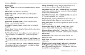
...Card, Data Card May Be Full-error reading card; Distress Call-a DSC distress call has been received. Fish Alarm (not a textual alarm, is detected. APPENDIX > MESSAGES Messages Accuracy Alarm-the GPS accuracy has fallen outside of user-set in the Deep Water Alarm. Antenna Input is Shorted-some...dealer or Garmin Product Support if the problem persists. Deep Water Alarm-the water is lower than the amount set value. Database Error-internal problem with the unit. Contact your dealer or Garmin Product Support to add new ones. This alarm does not show a message banner. 100 GPSMAP 292/298 Owner...
...Card, Data Card May Be Full-error reading card; Distress Call-a DSC distress call has been received. Fish Alarm (not a textual alarm, is detected. APPENDIX > MESSAGES Messages Accuracy Alarm-the GPS accuracy has fallen outside of user-set in the Deep Water Alarm. Antenna Input is Shorted-some...dealer or Garmin Product Support if the problem persists. Deep Water Alarm-the water is lower than the amount set value. Database Error-internal problem with the unit. Contact your dealer or Garmin Product Support to add new ones. This alarm does not show a message banner. 100 GPSMAP 292/298 Owner...
Owner's Manual
Page 109
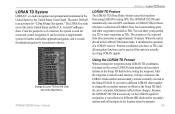
... those changes. GPSMAP 292/298 Owner's Manual Using the LORAN TD Format When creating new waypoints using GPS. You can show as TDs, and all navigation functions can show your position as a TD or enter waypoints as if the unit was actually receiving LORAN signals. ...From the perspective of a LORAN receiver. Position coordinates can be used for favorite fishing spots and other waypoints recorded as a supplemental system for harbor and harbor approach navigation, and it simulates the operation of a mariner, the system is...
... those changes. GPSMAP 292/298 Owner's Manual Using the LORAN TD Format When creating new waypoints using GPS. You can show as TDs, and all navigation functions can show your position as a TD or enter waypoints as if the unit was actually receiving LORAN signals. ...From the perspective of a LORAN receiver. Position coordinates can be used for favorite fishing spots and other waypoints recorded as a supplemental system for harbor and harbor approach navigation, and it simulates the operation of a mariner, the system is...
Owner's Manual
Page 114
...) Hereby, Garmin, declares that the GPSMAP 292/298 is no guarantee that may cause harmful interference to radio communications if not installed and used in a residential installation, and are designed to the equipment, and void your warranty and your Garmin product: www.garmin.com/products/ gpsmap298/. This product does not contain any interference received, including interference...
...) Hereby, Garmin, declares that the GPSMAP 292/298 is no guarantee that may cause harmful interference to radio communications if not installed and used in a residential installation, and are designed to the equipment, and void your warranty and your Garmin product: www.garmin.com/products/ gpsmap298/. This product does not contain any interference received, including interference...


