
Owner's Manual
Page 5
...77 Understanding Sonar 80 Flasher Page 84 Map Split Page 85 Appendix 86 Specifications 86 Installing the GPSMAP 292/298 External GPS Antenna..... 87 Mounting the GPSMAP 292/298 88 Installing the Transducer 90 Connecting the Power/Data Cable 92 Interfacing 93 Caring for the Screen ...93 Installing and Removing Data Cards 94 INTRODUCTION > TABLE OF CONTENTS Satellite Information 95 What is WAAS/EGNOS 96 What is a ...
...77 Understanding Sonar 80 Flasher Page 84 Map Split Page 85 Appendix 86 Specifications 86 Installing the GPSMAP 292/298 External GPS Antenna..... 87 Mounting the GPSMAP 292/298 88 Installing the Transducer 90 Connecting the Power/Data Cable 92 Interfacing 93 Caring for the Screen ...93 Installing and Removing Data Cards 94 INTRODUCTION > TABLE OF CONTENTS Satellite Information 95 What is WAAS/EGNOS 96 What is a ...
Owner's Manual
Page 44
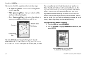
... for Navigation" when the GPSMAP 292/298 has collected the necessary data from satellites to the receiver's last known location. To disable/enable WAAS capability: 1. The sky view shows a bird's-eye view of the position of each satellite relative to calculate a fix. From the GPS tab, press ADJ/MENU. 2. Accuracy Receiver status WAAS status You can also...
... for Navigation" when the GPSMAP 292/298 has collected the necessary data from satellites to the receiver's last known location. To disable/enable WAAS capability: 1. The sky view shows a bird's-eye view of the position of each satellite relative to calculate a fix. From the GPS tab, press ADJ/MENU. 2. Accuracy Receiver status WAAS status You can also...
Owner's Manual
Page 45
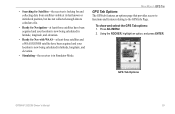
... Ready for Nav with WAAS-at least three satellites and a WAAS/EGNOS satellite have been acquired and your location is now being calculated in latitude, longitude, and elevation. • Simulating-the receiver is looking for Satellites-the receiver is in Simulator Mode.... Using the ROCKER, highlight an option, and press ENTER. • Searching for and collecting data from satellites visible at its last known or initialized position, but has not collected enough data to the GPS Info Page. GPS Tab Options GPSMAP 292...
... Ready for Nav with WAAS-at least three satellites and a WAAS/EGNOS satellite have been acquired and your location is now being calculated in latitude, longitude, and elevation. • Simulating-the receiver is looking for Satellites-the receiver is in Simulator Mode.... Using the ROCKER, highlight an option, and press ENTER. • Searching for and collecting data from satellites visible at its last known or initialized position, but has not collected enough data to the GPS Info Page. GPS Tab Options GPSMAP 292...
Owner's Manual
Page 92
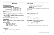
... Display: 5.0" diagonal (12.7 cm) 256-color TFT display with backlighting (234 x 320 pixels) Case: Fully gasketed, high-impact plastic alloy, waterproof to 70°C) Performance Receiver: Differential-ready 12 parallel channel WAAS-capable receiver Acquisition Times: Warm: Approx. 15 seconds Cold: Approx. 45 seconds AutoLocate: Approx. 2 minutes Update Rate: 1/second, continuous...
... Display: 5.0" diagonal (12.7 cm) 256-color TFT display with backlighting (234 x 320 pixels) Case: Fully gasketed, high-impact plastic alloy, waterproof to 70°C) Performance Receiver: Differential-ready 12 parallel channel WAAS-capable receiver Acquisition Times: Warm: Approx. 15 seconds Cold: Approx. 45 seconds AutoLocate: Approx. 2 minutes Update Rate: 1/second, continuous...
Owner's Manual
Page 101
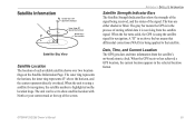
... satellite shows over two location rings on the location rings. GPSMAP 292/298 Owner's Manual 95 When the bar turns solid, the GPS is using a satellite for navigation. A "D" in the selected location format. The unit can be set to that differential corrections (WAAS) is being received, and the status of the signal. When the unit...
... satellite shows over two location rings on the location rings. GPSMAP 292/298 Owner's Manual 95 When the bar turns solid, the GPS is using a satellite for navigation. A "D" in the selected location format. The unit can be set to that differential corrections (WAAS) is being received, and the status of the signal. When the unit...
Owner's Manual
Page 102
... geostationary communication satellites that adheres to http://gps.faa.gov. 96 GPSMAP 292/298 Owner's Manual The Wide Area Augmentation System (WAAS) is WAAS/EGNOS? Two master stations, located on your GPS unit with increased accuracy at any operational SBAS system should be several services of providing your Garmin GPS receiver, the receiver automatically uses the method that provided by...
... geostationary communication satellites that adheres to http://gps.faa.gov. 96 GPSMAP 292/298 Owner's Manual The Wide Area Augmentation System (WAAS) is WAAS/EGNOS? Two master stations, located on your GPS unit with increased accuracy at any operational SBAS system should be several services of providing your Garmin GPS receiver, the receiver automatically uses the method that provided by...
Owner's Manual
Page 117
track logs Clear 15 Save 15 Track Tab 57 Active 57 Saved 57 Track Up 62 transducer 82, 90 transducer type 78 trip planning 56 Trip Tab 44 U underwater waypoints 76 Units Tab 66 V view 75 W WAAS 96 Disable/Enable 38 water speed 78, 80 Water Temperature Alarm 71 waypoints Creating 8 Creating Graphically 9 Editing 11 Enter/Mark 8 Move 12 Proximity 50 Reviewing 11 Underwater 76 waypoint lists Proximity 49 User 47 whiteline 74, 83 wiring installation 92 Z zoom 75 Zoom Keys 5 zoom settings 29 GPSMAP 292/298 Owner's Manual INDEX 111
track logs Clear 15 Save 15 Track Tab 57 Active 57 Saved 57 Track Up 62 transducer 82, 90 transducer type 78 trip planning 56 Trip Tab 44 U underwater waypoints 76 Units Tab 66 V view 75 W WAAS 96 Disable/Enable 38 water speed 78, 80 Water Temperature Alarm 71 waypoints Creating 8 Creating Graphically 9 Editing 11 Enter/Mark 8 Move 12 Proximity 50 Reviewing 11 Underwater 76 waypoint lists Proximity 49 User 47 whiteline 74, 83 wiring installation 92 Z zoom 75 Zoom Keys 5 zoom settings 29 GPSMAP 292/298 Owner's Manual INDEX 111
