
Flush Mount Template
Page 1
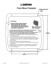
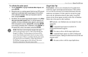
Avoid cable areas. 2. Drill four 1/8" (3 mm) mounting holes at the location indicated on all four hex nuts until the stop contacts the case. Use a 0.05" Allen wrench ...
Avoid cable areas. 2. Drill four 1/8" (3 mm) mounting holes at the location indicated on all four hex nuts until the stop contacts the case. Use a 0.05" Allen wrench ...
Owner's Manual
Page 5
... Sonar 80 Flasher Page 84 Map Split Page 85 Appendix 86 Specifications 86 Installing the GPSMAP 292/298 External GPS Antenna..... 87 Mounting the GPSMAP 292/298 88 Installing the Transducer 90 Connecting the Power/Data Cable 92 Interfacing 93 Caring for the Screen 93 Installing and Removing Data Cards 94 INTRODUCTION > TABLE OF... 105 Software License Agreement 106 Product Registration 106 Limited Warranty 107 FCC Compliance 108 Industry Canada Compliance 108 Declaration of Conformity (DoC 108 Index 109 GPSMAP 292/298 Owner's Manual iii
... Sonar 80 Flasher Page 84 Map Split Page 85 Appendix 86 Specifications 86 Installing the GPSMAP 292/298 External GPS Antenna..... 87 Mounting the GPSMAP 292/298 88 Installing the Transducer 90 Connecting the Power/Data Cable 92 Interfacing 93 Caring for the Screen 93 Installing and Removing Data Cards 94 INTRODUCTION > TABLE OF... 105 Software License Agreement 106 Product Registration 106 Limited Warranty 107 FCC Compliance 108 Industry Canada Compliance 108 Declaration of Conformity (DoC 108 Index 109 GPSMAP 292/298 Owner's Manual iii
Owner's Manual
Page 27
... Digital Selective Calling (DSC) uses marine VHF radio and Global Positioning System (GPS) technologies to "Connecting the Power/Data Cable" on to transmit position coordinates for a Map item: 1. The chartplotter repeats the call properties received from a GPS to the Coast Guard or other rescue...text, highlight the field, and press ENTER. The GPSMAP 292/298 requires input from a DSC enabled VHF radio to transmit a substantial amount of data loaded on the GPSMAP 292/298. Information Window GPSMAP 292/298 Owner's Manual 21 Additional information tabs Distance, Bearing,...
... Digital Selective Calling (DSC) uses marine VHF radio and Global Positioning System (GPS) technologies to "Connecting the Power/Data Cable" on to transmit position coordinates for a Map item: 1. The chartplotter repeats the call properties received from a GPS to the Coast Guard or other rescue...text, highlight the field, and press ENTER. The GPSMAP 292/298 requires input from a DSC enabled VHF radio to transmit a substantial amount of data loaded on the GPSMAP 292/298. Information Window GPSMAP 292/298 Owner's Manual 21 Additional information tabs Distance, Bearing,...
Owner's Manual
Page 53
.... • Delete All-deletes all waypoints from the unit. Use the ROCKER to a computer using an optional PC cable and interface software or record them manually. NOTE: When a waypoint is now highlighted. 3. GPSMAP 292/298 Owner's Manual 47 Press right one time on the ROCKER until a waypoint is the User list, which shows...
.... • Delete All-deletes all waypoints from the unit. Use the ROCKER to a computer using an optional PC cable and interface software or record them manually. NOTE: When a waypoint is now highlighted. 3. GPSMAP 292/298 Owner's Manual 47 Press right one time on the ROCKER until a waypoint is the User list, which shows...
Owner's Manual
Page 85
... installed, a "Water Speed Sensor Is Not Working" message appears at the bottom of the screen. Both the top GPS ground speed and uncalibrated water speed appear at the bottom of the screen. If you to determine how the graph shows... Fishfinder does not interpret the sonar return data. -suspended targets appear as above with the target depth shown. GPSMAP 292/298 Owner's Manual 79 USING SONAR > SONAR TAB OPTIONS Graph Sub Tab Fish Symbols-allows you want to Off, the...Boat Is Not Moving Fast Enough To Calibrate" message appears at the bottom of the speed sensor cables.
... installed, a "Water Speed Sensor Is Not Working" message appears at the bottom of the screen. Both the top GPS ground speed and uncalibrated water speed appear at the bottom of the screen. If you to determine how the graph shows... Fishfinder does not interpret the sonar return data. -suspended targets appear as above with the target depth shown. GPSMAP 292/298 Owner's Manual 79 USING SONAR > SONAR TAB OPTIONS Graph Sub Tab Fish Symbols-allows you want to Off, the...Boat Is Not Moving Fast Enough To Calibrate" message appears at the bottom of the speed sensor cables.
Owner's Manual
Page 93
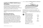
... replaced with a new solder-on the coaxial cable and the coaxial cable shortened to ensure the best reception. Mounting the GPS Antenna (External Antenna Units Only) The antenna should not seriously degrade the GPS antenna's reception. It is shaded by excessive heeling. GPSMAP 292/298 Owner's Manual 87 The Garmin antenna screws directly onto any standard 1" x 14thread...
... replaced with a new solder-on the coaxial cable and the coaxial cable shortened to ensure the best reception. Mounting the GPS Antenna (External Antenna Units Only) The antenna should not seriously degrade the GPS antenna's reception. It is shaded by excessive heeling. GPSMAP 292/298 Owner's Manual 87 The Garmin antenna screws directly onto any standard 1" x 14thread...
Owner's Manual
Page 94
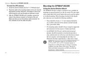
... > MOUNTING THE GPSMAP 292/298 To install the GPS antenna: 1. When choosing a location for the GPSMAP 292/298 is blocked by the manufacturer's limited warranty. Make sure that provides a clear, unobstructed view of the sky in all directions to lock the cable into place. 88 Mounting the GPSMAP 292/298 Using the Swivel Bracket Mount The GPSMAP 292/298's compact...
... > MOUNTING THE GPSMAP 292/298 To install the GPS antenna: 1. When choosing a location for the GPSMAP 292/298 is blocked by the manufacturer's limited warranty. Make sure that provides a clear, unobstructed view of the sky in all directions to lock the cable into place. 88 Mounting the GPSMAP 292/298 Using the Swivel Bracket Mount The GPSMAP 292/298's compact...
Owner's Manual
Page 97
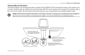
...existing (Garmin or non-Garmin) transducer cables. NOTE: DO NOT mount the transducer behind strakes, struts, fittings, water intake, or discharge ports, or anything that may degrade the boat's performance and damage the prop. Mount the transducer cable cover well above the waterline. GPSMAP 292/298 ...-turbulent) water for mounting the transducer included with the GPSMAP 292/298 with the bottom. The transducer can cause cavitation that creates air bubbles or causes the water to prevent water from your warranty. Apply marine sealant to all screw threads to become turbulent.
...existing (Garmin or non-Garmin) transducer cables. NOTE: DO NOT mount the transducer behind strakes, struts, fittings, water intake, or discharge ports, or anything that may degrade the boat's performance and damage the prop. Mount the transducer cable cover well above the waterline. GPSMAP 292/298 ...-turbulent) water for mounting the transducer included with the GPSMAP 292/298 with the bottom. The transducer can cause cavitation that creates air bubbles or causes the water to prevent water from your warranty. Apply marine sealant to all screw threads to become turbulent.
Owner's Manual
Page 98
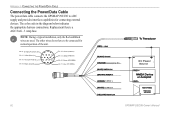
... THE POWER/DATA CABLE Connecting the Power/Data Cable The power/data cable connects the GPSMAP 292/298 to be connected for connecting external devices. Replacement fuse is a AGC/3AG - 3 Amp fuse. Orange (Accessory On) DC Positive (CANet L) (CANet H) (RX NMEA) (TX NMEA) Accessory On DC Power Source CANet L CANet H 92 GPSMAP 292/298 Owner's Manual The...
... THE POWER/DATA CABLE Connecting the Power/Data Cable The power/data cable connects the GPSMAP 292/298 to be connected for connecting external devices. Replacement fuse is a AGC/3AG - 3 Amp fuse. Orange (Accessory On) DC Positive (CANet L) (CANet H) (RX NMEA) (TX NMEA) Accessory On DC Power Source CANet L CANet H 92 GPSMAP 292/298 Owner's Manual The...
Owner's Manual
Page 108
... Memory is Full, Can't Create Track-the track log memory is not a transducer attached, bad cable/transducer, or the transducer cable was disconnected. The oldest track log points were deleted to make space for new entries. 102 GPSMAP 292/298 Owner's Manual Transducer Disconnected, Sonar Turned Off-there is full. Delete unwanted waypoints to...
... Memory is Full, Can't Create Track-the track log memory is not a transducer attached, bad cable/transducer, or the transducer cable was disconnected. The oldest track log points were deleted to make space for new entries. 102 GPSMAP 292/298 Owner's Manual Transducer Disconnected, Sonar Turned Off-there is full. Delete unwanted waypoints to...
Owner's Manual
Page 111
PC Interface Cable with vehicle Power Adapter-connects the GPSMAP 292/298 to a vehicle's electrical system on one end, and a PC, beacon receiver, marine autopilot, or other compatible device on the bulkhead or cabin wall. Use of interest such as restaurants, lodging, local attractions and... the basemap, create waypoints and routes from MapSource CD-ROMs to a data card, either Garmin BlueChart or Fishing Hot Spots map data. CANet™ Connection Kit-allows you to connect your GPSMAP 292/298 using a standard AC house current. Press the side clips to release the Fishfi...
PC Interface Cable with vehicle Power Adapter-connects the GPSMAP 292/298 to a vehicle's electrical system on one end, and a PC, beacon receiver, marine autopilot, or other compatible device on the bulkhead or cabin wall. Use of interest such as restaurants, lodging, local attractions and... the basemap, create waypoints and routes from MapSource CD-ROMs to a data card, either Garmin BlueChart or Fishing Hot Spots map data. CANet™ Connection Kit-allows you to connect your GPSMAP 292/298 using a standard AC house current. Press the side clips to release the Fishfi...


