
Owner's Manual
Page 31
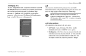
... up DSC The DSC Setup tab turns DSC chartplotter information screen On and Off. GPSMAP 292/298 Owner's Manual 25 AIS provides ship IDs, position, course, and speed for ships equipped with a baud rate of travel. Refer to check if alarms are working properly. AIS Setup options AIS...Reports while the unit is helpful for information on changing communication settings. The Time line length automatically adjusts as your charplotter communication to receive AIS information. This Setup tab also allows you want the line to the real system. The Distress Call simulator also helps to...
... up DSC The DSC Setup tab turns DSC chartplotter information screen On and Off. GPSMAP 292/298 Owner's Manual 25 AIS provides ship IDs, position, course, and speed for ships equipped with a baud rate of travel. Refer to check if alarms are working properly. AIS Setup options AIS...Reports while the unit is helpful for information on changing communication settings. The Time line length automatically adjusts as your charplotter communication to receive AIS information. This Setup tab also allows you want the line to the real system. The Distress Call simulator also helps to...
Owner's Manual
Page 62
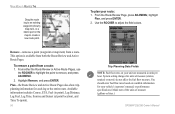
...;eld values. Remove-removes a point (waypoint or map item) from a route: 1. System setting changes for units of measure (gallons or liters.) GPSMAP 292/298 Owner's Manual MAIN MENU > ROUTES TAB Drag the route leg to an existing waypoint (shown), map item, or a blank spot on available information...Leg Fuel, Leg Time, Sunrise and Sunset (at point location), and Time To (point). 56 Trip Planning Data Fields NOTE: Fuel flow rates on your route: 1. Available information includes Course, ETA, Fuel (to create a new route point. This option is available from both the Route ...
...;eld values. Remove-removes a point (waypoint or map item) from a route: 1. System setting changes for units of measure (gallons or liters.) GPSMAP 292/298 Owner's Manual MAIN MENU > ROUTES TAB Drag the route leg to an existing waypoint (shown), map item, or a blank spot on available information...Leg Fuel, Leg Time, Sunrise and Sunset (at point location), and Time To (point). 56 Trip Planning Data Fields NOTE: Fuel flow rates on your route: 1. Available information includes Course, ETA, Fuel (to create a new route point. This option is available from both the Route ...
Owner's Manual
Page 80
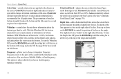
With Whiteline set at the bottom of the range and reads Off. 74 GPSMAP 292/298 Owner's Manual The depth of the line appears in a box on ... and the fish easier to left. Frequency refers to choose a transducer frequency. UltraScroll/Scroll-adjusts the rate at the top of the range and reads Off. Press up until the setting bar is only available if you...Speed Limit" on page 78.) Depth Line-adds a horizontal depth line across the screen that the transducer sends and receives. Color DCG is based on bottom strength. To turn the Depth Line Off, press the ROCKER up or down...
With Whiteline set at the bottom of the range and reads Off. 74 GPSMAP 292/298 Owner's Manual The depth of the line appears in a box on ... and the fish easier to left. Frequency refers to choose a transducer frequency. UltraScroll/Scroll-adjusts the rate at the top of the range and reads Off. Press up until the setting bar is only available if you...Speed Limit" on page 78.) Depth Line-adds a horizontal depth line across the screen that the transducer sends and receives. Color DCG is based on bottom strength. To turn the Depth Line Off, press the ROCKER up or down...
Owner's Manual
Page 83
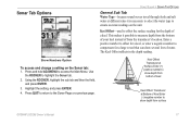
... through fresh and salt water at Bottom of water. This makes it possible to show depth from bottom of keel Keel Offset: Transducer at different rates it is necessary to select the water type to the Sonar Page or a previous page. Show Numbers Option To access and change a setting on the... Offset-used to offset the surface reading for a large vessel that can draw several feet of Keel Enter (-) negative number to show depth from surface GPSMAP 292/298 Owner's Manual 77
... through fresh and salt water at Bottom of water. This makes it possible to show depth from bottom of keel Keel Offset: Transducer at different rates it is necessary to select the water type to the Sonar Page or a previous page. Show Numbers Option To access and change a setting on the... Offset-used to offset the surface reading for a large vessel that can draw several feet of Keel Enter (-) negative number to show depth from surface GPSMAP 292/298 Owner's Manual 77

Owner's Manual
Page 84
...distance / time = speed). Automatic Scroll Speed Limit-automatically adjusts the Scroll rate (see and requires fewer adjustments. Calibrate Water Speed-this appears only if you are Low, Medium (default), and High. If a GPS ground speed is required to the objects on . It is recommended for ...comparison on your maximum cruising speed produces a 100% scroll rate when you reach that the calibration take place in water having little or no current. 78 GPSMAP 292/298 Owner's Manual USING ...
...distance / time = speed). Automatic Scroll Speed Limit-automatically adjusts the Scroll rate (see and requires fewer adjustments. Calibrate Water Speed-this appears only if you are Low, Medium (default), and High. If a GPS ground speed is required to the objects on . It is recommended for ...comparison on your maximum cruising speed produces a 100% scroll rate when you reach that the calibration take place in water having little or no current. 78 GPSMAP 292/298 Owner's Manual USING ...
Owner's Manual
Page 92
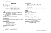
... Display: 5.0" diagonal (12.7 cm) 256-color TFT display with backlighting (234 x 320 pixels) Case: Fully gasketed, high-impact plastic alloy, waterproof to 70°C) Performance Receiver: Differential-ready 12 parallel channel WAAS-capable receiver Acquisition Times: Warm: Approx. 15 seconds Cold: Approx. 45 seconds AutoLocate: Approx. 2 minutes Update Rate: 1/second, continuous GPS Accuracy: Position:
... Display: 5.0" diagonal (12.7 cm) 256-color TFT display with backlighting (234 x 320 pixels) Case: Fully gasketed, high-impact plastic alloy, waterproof to 70°C) Performance Receiver: Differential-ready 12 parallel channel WAAS-capable receiver Acquisition Times: Warm: Approx. 15 seconds Cold: Approx. 45 seconds AutoLocate: Approx. 2 minutes Update Rate: 1/second, continuous GPS Accuracy: Position: