
Owner's Manual
Page 50
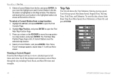
... Station in the list, the station is highlighted on the ROCKER to move the map pointer to open the Find Near Map Position Page. 3. To reset the data, choose from your location to open the Find Currents Page. 2. Select a Current Station, and press ENTER. As you find a station. ...and press ENTER to the highlighted station are shown at the bottom of the list. The distance and bearing from Reset Trip, Reset Max Speed, Reset Odometer, or Reset All, and press ENTER. 44 GPSMAP 292/298 Owner's Manual Press up or down on the Map window. Highlight the At field, and press ...
... Station in the list, the station is highlighted on the ROCKER to move the map pointer to open the Find Near Map Position Page. 3. To reset the data, choose from your location to open the Find Currents Page. 2. Select a Current Station, and press ENTER. As you find a station. ...and press ENTER to the highlighted station are shown at the bottom of the list. The distance and bearing from Reset Trip, Reset Max Speed, Reset Odometer, or Reset All, and press ENTER. 44 GPSMAP 292/298 Owner's Manual Press up or down on the Map window. Highlight the At field, and press ...
Owner's Manual
Page 67
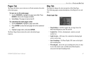
... default page sequence. Prefs Sub Tab • Map Outlines-On/Off: toggles the coverage boxes for the numbered spot. 3. GPSMAP 292/298 Owner's Manual 61 To customize the main pages order: 1. Select None. The Reset Pages button returns the unit to highlight a page name field. 2. Press ENTER to show a list of the...
... default page sequence. Prefs Sub Tab • Map Outlines-On/Off: toggles the coverage boxes for the numbered spot. 3. GPSMAP 292/298 Owner's Manual 61 To customize the main pages order: 1. Select None. The Reset Pages button returns the unit to highlight a page name field. 2. Press ENTER to show a list of the...
Owner's Manual
Page 104
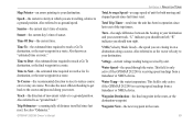
..., or the next waypoint in the route. GPS Accuracy-estimated accuracy of the GPS signals and satellite geometry. Leg Time-the time required to travel from and to the GPSMAP 292/298. Max Speed-the maximum second-by-second speed recorded since last reset. Off Course-the distance you estimate to ...a destination. DOP (Dilution of Precision)-reflects the quality of the GPS location. ETA at Destination-the time you...
..., or the next waypoint in the route. GPS Accuracy-estimated accuracy of the GPS signals and satellite geometry. Leg Time-the time required to travel from and to the GPSMAP 292/298. Max Speed-the maximum second-by-second speed recorded since last reset. Off Course-the distance you estimate to ...a destination. DOP (Dilution of Precision)-reflects the quality of the GPS location. ETA at Destination-the time you...
Owner's Manual
Page 105
... en route." Sunset-the current day's time of sunrise. Track-the direction of unit for both moving and stopped speeds since last reset. GPSMAP 292/298 Owner's Manual APPENDIX > NAVIGATION TERMS Total Average Speed-average speed of movement relative to reach a Go To destination, or the... indicates you are travelling, relative to a ground position. Water Temp-the water temperature. This field is only active if the GPSMAP 292/298 is receiving speed readings from a transducer or NMEA device. Also known as ground speed. Time to Next-the estimated time required to a ground ...
... en route." Sunset-the current day's time of sunrise. Track-the direction of unit for both moving and stopped speeds since last reset. GPSMAP 292/298 Owner's Manual APPENDIX > NAVIGATION TERMS Total Average Speed-average speed of movement relative to reach a Go To destination, or the... indicates you are travelling, relative to a ground position. Water Temp-the water temperature. This field is only active if the GPSMAP 292/298 is receiving speed readings from a transducer or NMEA device. Also known as ground speed. Time to Next-the estimated time required to a ground ...

