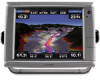
Garmin GPSMAP 7212 Support Question
Garmin GPSMAP 7212 Support Question
Find answers below for this question about Garmin GPSMAP 7212.Need a Garmin GPSMAP 7212 manual? We have 8 online manuals for this item!
Question posted by Mihales48 on October 9th, 2015
How Do Reset Tracks On The 7212
need to reset tracks
Current Answers
Answer #1: Posted by TechSupport101 on October 9th, 2015 9:56 AM
TechSupport101

Member since:
May 24th, 2013 Points: 12,171,305

Member since:
May 24th, 2013 Points: 12,171,305
Refer to page 41 of the Owner's Manual here https://www.helpowl.com/manuals/Garmin/GPSMAP7212/76380
Related Garmin GPSMAP 7212 Manual Pages
Installation Instructions - Page 1
... the chartplotter to use the GPSMAP 6000/7000 chartplotter. Mount the GPS antenna (page 4). 3.
C
Printed in the space provided. by phone at +44 (0) 870.8501241. The serial numbers are not necessary in each device. Product Registration
Help us better support you by phone at most marine dealers. You need the appropriate fasteners, tools, and...
Installation Instructions - Page 2
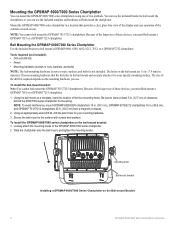
....
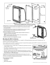
Be sure to leave at least 5 in . (63.5 cm) from a magnetic compass.
2. NOTE: To avoid interference, mount GPSMAP 6008/6208 chartplotters 15 in. (38.1 cm), GPSMAP 6012/6212 chartplotters 16 in. (40.6 cm), and GPSMAP 7012/7212 chartplotters 25 in . (12.7 cm) of the controls or touch screen. Loosely attach the mounting knobs to...
Installation Instructions - Page 3
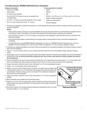
... template.
• Ensure that the surface on the flush-mount template for the clearance-space needed by fastening an included 60 mm M3 × 0.5 screw through the smaller 9/64 in.... from overheating.
• To avoid interference, mount GPSMAP 6008/6208 chartplotters 15 in. (38.1 cm), GPSMAP 6012/6212 chartplotters 16 in. (40.6 cm), GPSMAP 7012/7212 chartplotters 25 in. (63.5 cm) and 7015/...
Installation Instructions - Page 4
...Tools required (not included): • Drill and drill bits • Screwdrivers • Marine sealant (optional)
EMI
Better
Best Good
SS BARNETT
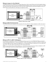
EMI (Electromagnetic Interference) from ...VHF Radio Antenna
GPS 17x Placement Considerations
GPSMAP 6000/7000 Series Installation Instructions Mounting covers (×2)
Mounting the GPS 17x Antenna
You can surface mount the GPS 17x antenna, ...
Installation Instructions - Page 5

... the 1 in place ➋.
8.
Surface-mount
3. Do not drill through the pole or outside the pole: 1. To mount the GPS 17x with a marine sealant. 9. Connect a NMEA 2000 drop cable to the boat.
4. GPSMAP 6000/7000 Series Installation Instructions
This will help to the adapter with the included M3 set screw ➌.
6. (Optional) With...
Installation Instructions - Page 6
... -deck mounting bracket. 4. Mounting surface
Adhesive pads GPS 17x antenna
Under-deckmounting bracket
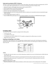
Installing Cables
The GPSMAP 6000/7000 series chartplotter is packaged in the under ...cable • A 17-pin marine video cable (the GPSMAP 7015/7215 chartplotter is packaged with the locking rings pre-installed. After you can be used with a
GPSMAP 6000/7000 cable. Secure the under...
Installation Instructions - Page 9
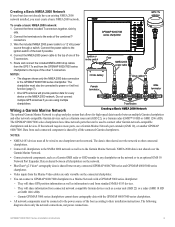
... the network.
• BlueChart® g2 Vision® cartography data is a plug-and-play system that can connect a GPSMAP 6000/7000 chartplotter to a Marine Network with a GPSMAP 3000 series chartplotter:
◦ They will share GPS position information as well as information to and from standard NMEA 0183 devices.
◦ They will provide position data...
Installation Instructions - Page 11
... expander. however, they do not show the network connections; Wire the GPS antenna and additional NMEA devices to the power supply for the boat. The existing chartplotter and the new GPSMAP 6000/7000 series chartplotter share NMEA 0183 data and Garmin Marine Network data. These diagrams show the power connections.
GSD 22 sounder...
Installation Instructions - Page 15
...
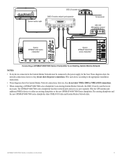
chartplotter
Power cable NMEA 0183 Cable
Wire see table for the GPSMAP 6000/7000 chartplotter to a Garmin Marine Network.
Solder all connections and seal them with a lamp, a horn, or both, to a GPS 17 or GPS 17 HVS Antenna
GPS 17 or GPS 17 HVS
antenna
GPSMAP 6000/7000 Series Installation Instructions
15
on)
> Green (Data out)
GREEN...
Installation Instructions - Page 16
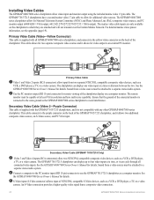
... to avoid interference. For detailed marine video pinout information, see the appendix (page 19). See the GPSMAP 6000/7000 Series Owner's Manual for National Television System Committee (NTSC) and Phase Alternate Line (PAL) composite video sources, and PC monitor output (6008/6208 = VGA output, 6012/6212/7012/7212/7015/7215 = XGA output). An...
Installation Instructions - Page 17
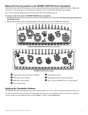
...Connections to the GPSMAP 6000/7000 Series Chartplotter
After the power cable and the GPS antenna (as well as any optional Garmin Marine Network devices, NMEA...➊
➏
GPSMAP 6008/6208/6012/6212/7012/7212 Connectors
➋ ➊
➊ ➊
➎
➍
➌
➐
➏
GPSMAP 7015/7215 Connectors
➊ Garmin Marine Network connectors (×3) ...
Installation Instructions - Page 18
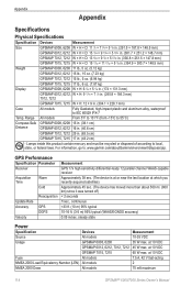
... 7015, 7215
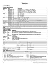
17 lb., 6 oz. (7.87 kg)
Display
GPSMAP 6008, 6208
W × H: 6 ¾ × 5 1/8 in. (174 × 131.3 mm)
GPSMAP 6012, 6212, 7012, 7212 W × H: 9 /11 16 × 7 1/4 in. (245.8 × 184.3 mm)
GPSMAP 7015, 7215
W × H: 12 × 9 in . (43.2 cm)
Hg
-
GPS Performance
Specification Parameter
Receiver
Acquisition Time
Warm
Cold
Reacquisition
Update Rate...
Installation Instructions - Page 19

...VGA, horizontal sync VGA, vertical sync VGA, overall shield
Primary Marine Video Cable Pin Assignments
GPSMAP 6000/7000 Series Installation Instructions
19 Marine Video Cable Pin Assignments
Connector
Pin
RCA 1 center 2
RCA...Update GNSS Position Data Cross Track Error Navigation Data Navigation Route/Waypoint Info GNSS Sats in View Wind Data Temperature
GPSMAP 6000/7000 series chartplotters ...
Owner's Manual - Page 3
... an item, either press the soft key along the right side of the screen (GPSMAP 6000 series units) or use your finger to select it. For example, if you...product box for the following products:
• GPSMAP® 6008 • GPSMAP 6208 • GPSMAP 6012 • GPSMAP 6212 • GPSMAP 7012 • GPSMAP 7212 • GPSMAP 7015 • GPSMAP 7215
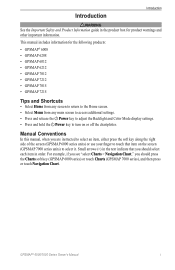
Tips and Shortcuts
• Select Home ...
Owner's Manual - Page 12

...from supplemental maps, if available. From the Home screen, select Charts > Navigation Chart. Marine services
Exposed wreck
Submerged wreck
Beacon Your boat
Buoy Zoom scale
Navigation Chart with a preprogrammed...
• Navigation Chart-shows navigation data available on the chartplotter.
The GPSMAP 6208, 6212, 7212, and 7215 chartplotters have a basic worldwide imagery map. The charts and ...
Owner's Manual - Page 23
...GPS heading, and other vessels.
Complete an action:
• Select Display Range to show details about AIS-activated and MARPA-tagged vessels. • Select Proj. Select a distance.
• Select MARPA > Show to show the tracks... GPSMAP 7000 series, touch an AIS vessel. 4. The details, projected heading, and trails settings configured for an AIS Vessel Note: The Fishing chart and Mariner's...
Owner's Manual - Page 120
... Receiver
Acquisition Time
Warm Cold
Update Rate Accuracy
Velocity
Reacquisition
GPS DGPS
Measurement GPS 17x high-sensitivity differential-ready 12 parallel channel WAAS-capable ... or disposed of according to 55°C)
Compass Safe GPSMAP 6008, 6208 15 in. (38.1 cm)
Distance
GPSMAP 6012, 6212 16 in. (40.6 cm)
GPSMAP 7012, 7212 25 in. (63.5 cm)
GPSMAP 7015, 7215 17 in . (304.1 × 228...
Owner's Manual - Page 121
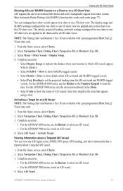
... the chartplotter is complete" appears. 4. From the Home screen, select Configure > System > GPS.
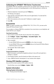
Appendix
Calibrating the GPSMAP 7000 Series Touchscreen
The GPSMAP 7000 series chartplotter touchscreen does not normally require calibration. Touch OK. Screenshots
Note: To capture screenshots using a GPSMAP 7012, 7212, 7015 or 7515, you want to calibrate the screen.
1. You can view the...
Owner's Manual - Page 127
...tracks clearing 41 retracing 40 saving 40
add turn 36 aerial photos 21, 26 AIS
radar 79 targeting 15, 113 threats 18, 79 alarms anchor drag 67 arrival 67 clock 68 collision 15, 18, 77, 79 deep water 105 fish 106 GPS...chart symbols 7 data cards 21 Fish Eye 3D 24 Mariner's Eye 3D 22 POIs 27
C
celestial information 48... 9 sonar cone 24 suspended targets 24 tracks 24 fishing chart AIS 18 currents 10 data...
Owner's Manual - Page 129
...position format 61 position report 110 position tracking 110 power connector 2 power key ... 51 rear panel 1 reset 116
Rocker 1 roses ...GPS accuracy 68 hazard colors 23 heading 61 heading line 12, 94, 97 inset map 8, 97 interval 41 keel offset 106 land POIs 13, 98 lane width 20 light sectors 13, 98 look-ahd spd 94 map datum 61 marine...GPSMAP® 6000/7000 Series Owner's Manual 123 precision ...
Similar Questions

How Do I Go Into Simulation Mode On A Garmin Marine Gps Modle741xs
how do I use simulation mode on a garmin 741xs marine ver
how do I use simulation mode on a garmin 741xs marine ver
(Posted by Curthupp 6 years ago)


541s Marine Gps. Depth Not Reading Out.
Depth has been working since installed. Now blank. Is there an on off control for this that may have...
Depth has been working since installed. Now blank. Is there an on off control for this that may have...
(Posted by therad50 11 years ago)
Does A Garmin Gpsmap 750s Need Its Own Power When Connected To A Nmea2000 Bus?
(Posted by 56stewart 11 years ago)