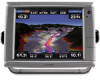
Garmin GPSMAP 7212 Support Question
Garmin GPSMAP 7212 Support Question
Find answers below for this question about Garmin GPSMAP 7212.Need a Garmin GPSMAP 7212 manual? We have 8 online manuals for this item!
Question posted by loulcha on May 3rd, 2014
7212 Garmin How To Use
The person who posted this question about this Garmin product did not include a detailed explanation. Please use the "Request More Information" button to the right if more details would help you to answer this question.
Current Answers
Related Garmin GPSMAP 7212 Manual Pages
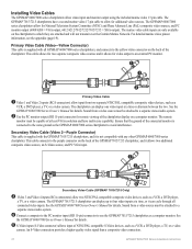
Installation Instructions - Page 1
... video monitor (page 16). If any questions while installing your GPSMAP 6000/7000 series chartplotter and GPS 17x in the space provided. Mount the GPSMAP 6000/7000 series chartplotter (page 2). 2. The following instructions.
Before installing your convenience: • Connecting the chartplotter to other Garmin Marine Network compatible devices, such as a VHF radio with DSC (page...
Installation Instructions - Page 6
... locking ring from sources of the chartplotter.
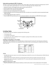
GPSMAP 6000/7000 Series Installation Instructions Determine the location on a cable: 1. Use extreme care to mount the GPS 17x. 2. Route the NMEA 2000 drop cable away from a NMEA 2000 cable while routing the cable.
• Optional Garmin Marine Network components use the under-deck mount under -deck mounting bracket...
Installation Instructions - Page 7
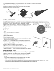
... to the power supply for the Marine Video cable. Notes: • Use 14 AWG shielded wiring for extended runs of wire to this line for the boat.
1. Use this hole (no trim) for trimming instructions. Spread the grommet apart at www.garmin.com. Wiring the Power Cable
The GPSMAP 6000/7000 series chartplotter must be...
Installation Instructions - Page 8
...your boat already has a NMEA 2000 network installed, use the included T-connectors and drop cable to connect a GPSMAP 6000/7000 series
chartplotter and a GPS 17x antenna to your NMEA 2000 network. Disconnect ...power or it will not function.
• One GPS antenna will provide position data for the GPS 17x antenna). Notice If you disconnected.
6. garmin.com. To extend the NMEA 2000 backbone (if...
Installation Instructions - Page 9
...system that can connect a GPSMAP 6000/7000 chartplotter to a Marine Network with a GPSMAP 3000 series chartplotter:
◦ They will share GPS position information as well as a Garmin GMR radar or GSD sounder to any connected GPSMAP 6000/7000 series and GPSMAP 4000/5000 series chartplotter.
• Video inputs from the Marine Video cables are using multiple chartplotters. Creating a Basic...
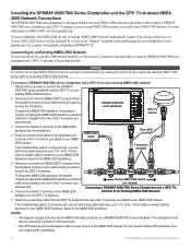
Installation Instructions - Page 11
...
To transducer
GDL 30A XM weather receiver
Garmin GPSMAP 3000 series
chartplotter
Garmin GPSMAP 6000/7000
series chartplotter
Connecting a GPSMAP 6000/7000 Series Chartplotter to an Existing Garmin Marine Network
Notes:
• Every device connected to the Garmin Marine Network must be connected to an existing Garmin Marine Network, the GMS 10 can be used but is not
necessary.
however...
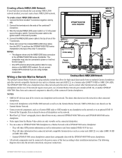
Installation Instructions - Page 15
... in)
Yellow (on your boat, you are using more than one Garmin chartplotter over a Garmin Marine Network, do not wire more than one chartplotter to a GPS 17 or GPS 17 HVS Antenna
GPS 17 or GPS 17 HVS
antenna
GPSMAP 6000/7000 Series Installation Instructions
15 Wire the existing GPS 17 or GPS 17 HVS antenna to the included 19-pin...
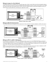
Installation Instructions - Page 16
...= VGA output, 6012/6212/7012/7212/7015/7215 = XGA output). The GPSMAP 7015/7215 chartplotters have multi-sync capability...marine video 17-pin cable to use the GPSMAP 7015/7215 chartplotter as a computer monitor. See
the GPSMAP ...connection.
16
GPSMAP 6000/7000 Series Installation Instructions The marine video cable inputs are attached and will not transmit over the Garmin Marine Network.
...
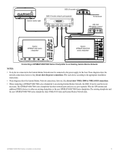
Installation Instructions - Page 17
...GPSMAP 6000/7000 Series Installation Instructions
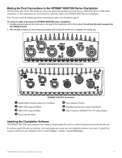
17 Making the Final Connections to the GPSMAP 6000/7000 Series Chartplotter
After the power cable and the GPS antenna (as well as any optional Garmin Marine...
GPSMAP 6008/6208/6012/6212/7012/7212 Connectors
➋ ➊
➊ ➊
➎
➍
➌
➐
➏
GPSMAP 7015/7215 Connectors
➊ Garmin Marine ...
Installation Instructions - Page 18
...
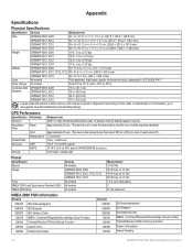
Acquisition Time
Warm
Cold
Reacquisition
Update Rate
Accuracy
GPS
DGPS
Velocity
Measurement GPS17x: High Sensitivity Differential-ready... in. (40.6 cm)
GPSMAP 7012, 7212
25 in. (63.5 cm)
GPSMAP 7015, 7215
17 in . (304.1 × 228.1 mm)
Case
All models
Fully gasketed, high-impact plastic and aluminum alloy, waterproof to : www.garmin.com/aboutGarmin/environment/disposal.jsp...
Owner's Manual - Page 41

... keyboard. Moving a Saved Waypoint 1. Select Review > Move. 4.
Select Navigation Chart or Fishing Chart. 3. From the Home screen, select Information > User Data > Waypoints. 2. For the GPSMAP 7000 series, use the Rocker to 250 waypoints. From the Home screen, select Information > User Data > Waypoints. 2.
This procedure does not save up to change the water...
Owner's Manual - Page 121
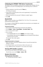
...To capture screenshots using a GPSMAP 7012, 7212, 7015 or ...System > GPS.
Select Configure > System > Beeper/Display > Screenshot Capture > On. 3. Viewing GPS Satellite Locations
You can capture as a bitmap (.BMP) file a screenshot of GPS satellites in...GPSMAP 7000 series, press the HOME button on the memory card. 3. However, if the buttons do not seem to be responding properly, use the Garmin...
Quick Reference Guide - Page 2
...key. For the GPSMAP 6000 series, use the Rocker to move the waypoint using the Go To feature.
to your path. Garmin®, the Gamin logo, GPSMAP®, BlueChart®,...the Home screen, select Configure > System > Beeper/Display > Backlight > Backlight.
2. Select the marine service category to which you can choose from only the options available to arrange
screen 2
the screens ...
Supplement - Page 2

...any storage medium, for current updates and supplemental information concerning the use and operation of Garmin. DAFIF™ is subject to print one copy of this ...(913) 397.8282
Garmin (Europe) Ltd. Garmin®, the Gamin logo, GPSMAP®, BlueChart®, and g2 Vision® are registered trademarks of this document is a trademark of Garmin. Liberty House Hounsdown Business...
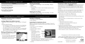
Technical Reference for Garmin NMEA 2000 Products - Page 5
... the parts included with a GFS 10 fuel sensor.
NMEA 2000 Fundamentals
NMEA 2000 Fundamentals
A NMEA 2000 network is made of commonly used NMEA 2000 terms, see page 8.
Technical Reference for Garmin NMEA 2000 Products
After you have a NMEA 2000 network on the product box shows which NMEA 2000 components are not included...
Technical Reference for Garmin NMEA 2000 Products - Page 12
... with a nominal voltage of any two points on the network, or may use a converter or adapter to add Garmin NMEA 2000 equipment, there are unsure of 12 Vdc. Power should have an...your boat has an existing NMEA 2000 installation, and you will need to consider:
Cable Type: Garmin uses NMEA 2000 micro connectors for assistance. To estimate this distance, measure between any of a single...
Technical Reference for Garmin NMEA 2000 Products - Page 13
... Waypoint Distance to the NMEA 2000-certified display devices (such as a GPSMAP 4000/5000 series chartplotter or a GMI 10) on the NMEA 2000 ...Garmin Chartplotter and GPS Antenna
Garmin Chartplotter and GPS Antenna
Garmin Chartplotter Garmin Chartplotter and GPS Antenna Garmin Chartplotter and GPS Antenna Garmin Chartplotter and GPS Antenna Garmin Chartplotter and GPS Antenna Heading Sensor GPS...
Technical Reference for Garmin NMEA 2000 Products - Page 14
..., and Heading Sensor [130306 - GNSS Position
Typical Sender GPS Antenna
129026 - Nav Data
Garmin Chartplotter and GPS Antenna
129026 - COG/SOG, 129029 - Vessel Heading, and 128259 - GNSS Position])
(If a GPS antenna is not present, a less-accurate reading can be calculated using only the Wind Sensor and GPS antenna [130306 - General NMEA 2000 Data Type Requirements
Category...
Technical Reference for Garmin NMEA 2000 Products - Page 15
...
True Wind Angle
130306 - Nav Data
Garmin Chartplotter and GPS Antenna
Maximum Apparent Wind Speed 130306 - Water Speed (If a Water Speed Sensor is not present, a less-accurate reading can be calculated using only the Wind Sensor, Water Speed Sensor, and Heading Sensor [130306 - GNSS Position])
Either a Wind Sensor, a Heading Sensor, and Speed Sensor...
Technical Reference for Garmin NMEA 2000 Products - Page 27

... in the package. NMEA 2000-Certified Sensor Configuration Information
NMEA 2000-Certified Sensor Configuration Information
Garmin NMEA 2000-certified sensors each have moved the boat many miles without using the GPS 17x, for example, you can force the GPS 17x to acquire satellites. To restore factory default settings: 1. While viewing the NMEA 2000 configuration...
Similar Questions

How Do I Go Into Simulation Mode On A Garmin Marine Gps Modle741xs
how do I use simulation mode on a garmin 741xs marine ver
how do I use simulation mode on a garmin 741xs marine ver
(Posted by Curthupp 6 years ago)


Our Garmin Will Not Power Up. Does It Have To Have Sim Card To Power Up?
(Posted by dudleybv 8 years ago)

541s Marine Gps. Depth Not Reading Out.
Depth has been working since installed. Now blank. Is there an on off control for this that may have...
Depth has been working since installed. Now blank. Is there an on off control for this that may have...
(Posted by therad50 11 years ago)