
Owner's Manual
Page 27
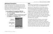
...: 1. Digital Selective Calling (DSC) uses marine VHF radio and Global Positioning System (GPS) technologies to scroll. For connection information, refer to "Connecting the Power/Data Cable" on the GPSMAP 292/298. To scroll the text, highlight the field, and press ENTER. Use the ROCKER to transmit and receive location information. An emergency DSC Distress...
...: 1. Digital Selective Calling (DSC) uses marine VHF radio and Global Positioning System (GPS) technologies to scroll. For connection information, refer to "Connecting the Power/Data Cable" on the GPSMAP 292/298. To scroll the text, highlight the field, and press ENTER. Use the ROCKER to transmit and receive location information. An emergency DSC Distress...
Owner's Manual
Page 65
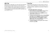
...compatible units and Garmin's MapSource PC program. Insert the data card. Highlight Save To Card, and press ENTER to save the selected items to a data card. Press QUIT. From the Card tab, select the check box next to each type of your GPSMAP 292/298. Highlight Replace..., highlight Merge From Card, and press ENTER to transmit and receive location information. DSC is transferred. GPSMAP 292/298 Owner's Manual 59 DSC Tab Digital Selective Calling (DSC) uses marine VHF radio and Global Positioning System (GPS) technologies to combine the selected items with those of item you...
...compatible units and Garmin's MapSource PC program. Insert the data card. Highlight Save To Card, and press ENTER to save the selected items to a data card. Press QUIT. From the Card tab, select the check box next to each type of your GPSMAP 292/298. Highlight Replace..., highlight Merge From Card, and press ENTER to transmit and receive location information. DSC is transferred. GPSMAP 292/298 Owner's Manual 59 DSC Tab Digital Selective Calling (DSC) uses marine VHF radio and Global Positioning System (GPS) technologies to combine the selected items with those of item you...
Owner's Manual
Page 109
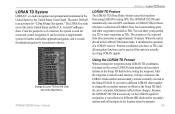
...mariner, the system is used for favorite fishing spots and other waypoints recorded as TDs. GPSMAP 292/298 Owner's Manual Using the LORAN TD Format When creating new waypoints using GPS. The LORAN system covers the entire United States and the U.S. It can show as if the unit was actually receiving... 103 You can be used as a supplemental system for those changes. Because the GPSMAP 292/298 does not rely on the Main Menu. The GPSMAP 292/298 unit automatically converts GPS coordinates to LORAN TDs for harbor and harbor approach navigation, and it can be...
...mariner, the system is used for favorite fishing spots and other waypoints recorded as TDs. GPSMAP 292/298 Owner's Manual Using the LORAN TD Format When creating new waypoints using GPS. The LORAN system covers the entire United States and the U.S. It can show as if the unit was actually receiving... 103 You can be used as a supplemental system for those changes. Because the GPSMAP 292/298 does not rely on the Main Menu. The GPSMAP 292/298 unit automatically converts GPS coordinates to LORAN TDs for harbor and harbor approach navigation, and it can be...


