
Garmin GPSMAP 292 Support Question
Garmin GPSMAP 292 Support Question
Find answers below for this question about Garmin GPSMAP 292 - Marine GPS Receiver.Need a Garmin GPSMAP 292 manual? We have 4 online manuals for this item!
Question posted by larsburmeister on June 30th, 2011
The Gps Will Not Pick Up The Satelite Signals.
I reinstalled the Garmin GPSMAP 292 after the winter break only to find out it will not pick up the satelite signals. (The graphs wont show)
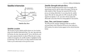
It indicates only the position where it is mored. although we are at other location/positions.
All other functions seems to be OK
Current Answers
Related Garmin GPSMAP 292 Manual Pages
Declaration of Conformity - Page 1
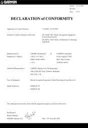
Estate, Romsey, Hampshire, SO51 9DL, U.K.
Marine Navigation Equipment (Global Positioning System Receiver)
GPSMAP 292 GPSMAP 298
The undersigned does hereby declare that the equipment complies to which Conformity is Declared:
73/23/EEC, 89/336/EEC
IEC 60945-2002: Marine Navigational Equipment - GARMIN (Europe) Ltd, The Quadrangle, Abbey Park Ind. General Requirements EN 60950-1:2001 ...
Owner's Manual - Page 3
... a route, and using the pages.
The Using Sonar section provides detailed explanations about installing your sonar options.
GPSMAP 292/298 Owner's Manual
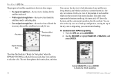
i The Introduction section contains the Table of your Garmin dealer immediately. The GPSMAP 292/298 utilizes the proven performance of Garmin GPS and full-featured mapping to configure your chartplotter, contact...
Owner's Manual - Page 7
... you turn on the GPSMAP 292/298: 1. Install the antenna in AutoLocate Mode.
To ensure proper initialization, the GPSMAP 292/298 is shown after the unit gets a position fix, or you press either ENTER or QUIT. When the self-test is blank, release the POWER key. The GPS Information Page appears as the receiver begins acquiring satellites.
Owner's Manual - Page 8
... for each bar.
• No signal strength bars-the receiver is looking for Navigation" during this process, it helps to initialize the unit. Use the ROCKER to move the map pointer to use .
2
GPSMAP 292/298 Owner's Manual
Using the ROCKER, highlight Initialize Position, and press ENTER. When viewing the GPS tab on the ROCKER until...
Owner's Manual - Page 9
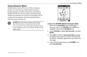
... > USING SIMULATOR MODE
To place the GPSMAP 292/298 in mind that appears at the top of each of the screen.
Press up or down on , "Simulating" appears at the bottom of the main pages. 4.
Keep in Simulator Mode: 1. Using Simulator Mode
Simulator Mode turns the GPS receiver off the Simulator Mode, press ADJ...
Owner's Manual - Page 27
... along the bottom.
The GPSMAP 292/298 requires input from a GPS to show position, and sound/show
the information.
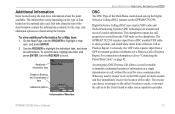
An emergency DSC Distress Call allows a vessel in a single transmission or call, without the need for the item. When any nearby rescuer receives the DSC signal, an alarm sounds and they immediately receive the location of the Main...
Owner's Manual - Page 28
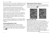
....
Garmin does not provide MMSI numbers.
Anytime a vessel receives a DSC call, they are in transit to the caller's location. In order to use DSC, users must first register their database while they can choose to create a waypoint or to show the positions of one another. Understanding Distress Calls When the GPSMAP 292/298 receives a Distress...
Owner's Manual - Page 43
... any given moment. Press QUIT to the highlighted item. The signal strength is shown on a bar graph for each satellite, with the satellite number below. See page 6 for additional submenu options, or press ENTER to make changes to exit the Main Menu. GPSMAP 292/298 Owner's Manual
37 Either press ADJ/MENU for additional...
Owner's Manual - Page 44
... point a position directly overhead.
The unit then updates the location, date, and time.
38
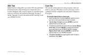
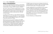
Highlight WAAS Off, and press ENTER to the receiver's last known location. Signal strength bars
The status field indicates "Ready for use the sky view to help determine if any satellites are ready for Navigation" when the GPSMAP 292/298 has...
Owner's Manual - Page 45
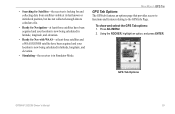
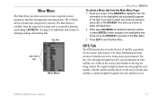
...receiver is in Simulator Mode. Press ADJ/MENU. 2. Using the ROCKER, highlight an option, and press ENTER. GPS Tab Options
GPSMAP 292/298 Owner's Manual
39
To show and select the GPS Tab options: 1. MAIN MENU > GPS TAB
GPS Tab Options The GPS...; Simulating-the receiver is looking for and collecting data from satellites visible at its last known or initialized position, but has not collected ...
Owner's Manual - Page 65
... marine VHF radio and Global Positioning System (GPS) technologies to overwrite all selected items on DSC and using it can be exchanged with other compatible units and Garmin's MapSource PC program. Insert the data card. From the Card tab, select the check
box next to combine the selected items with your GPSMAP 292/298. Press QUIT. GPSMAP 292...
Owner's Manual - Page 92
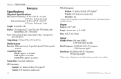
... pixels)
Case: Fully gasketed, high-impact plastic alloy, waterproof to 70°C)
Performance Receiver: Differential-ready 12 parallel channel WAAS-capable
receiver
Acquisition Times: Warm: Approx. 15 seconds Cold: Approx. 45 seconds AutoLocate: Approx. 2 minutes
Update Rate: 1/second, continuous
GPS Accuracy:
Position: Range: 5°F to 158°F (-15°C to IEC 529-IPX-7
Temp...
Owner's Manual - Page 93
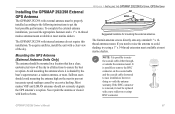
... avoid shading, try using a 1" x 14-thread extension mast available at most marine dealers. If you need to raise the antenna to get the best possible performance..., a radome antenna, or mast.
APPENDIX > INSTALLING THE GPSMAP 292/298 EXTERNAL GPS ANTENNA
Suggested locations for mounting the external antenna.
The Garmin antenna screws directly onto any standard 1" x 14thread antenna mount...
Owner's Manual - Page 101
... of storing orbital data it is receiving from the satellite's on-board atomic clock. GPSMAP 292/298 Owner's Manual
95 The gray bar means the GPS is being received, and the status of the screen. When the unit is using a satellite for navigation, the satellite number is using the satellite signal for navigation. The unit can...
Owner's Manual - Page 102
... your Garmin GPS receiver, the receiver automatically uses the method that broadcast integrity information and differential correction data as EGNOS. According to http://gps.faa.gov.
96
GPSMAP 292/298 ... stations positioned across the United States that provided by ground stations, may not improve accuracy, even when receiving signals from the reference stations and create a GPS data ...
Owner's Manual - Page 103
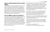
...can obtain MMSI assignments from their ship station license. GPSMAP 292/298 Owner's Manual
97 The 9-digit MMSI number ....
To receive information on a phone, you require a Ship Station license contact: http://wireless.fcc.gov/marine/ fctsht14.... carry VHF, EPIRB (Emergency Position Indicating Radio Beacons), and Radar)...Garmin does not supply this number. What is responsible for...
Owner's Manual - Page 104
...the fuel required to travel from the current location to the indicated route waypoint. GPS Accuracy-estimated accuracy of distance travelled, based on current speed...GPS signals and satellite geometry. Leg Fuel-the fuel required to travel from a route waypoint to a Go To destination, or the final waypoint in the route. Moving Trip Timer-total time the unit has been moving . GPSMAP 292...
Owner's Manual - Page 106
...distance from a destination waypoint. Contact your dealer or Garmin Product Support.
Can't Unlock Maps-data on data ... reached maximum of the antenna wiring is indicated by the amount of the Drift Alarm ...
APPENDIX > MESSAGES
Messages
Accuracy Alarm-the GPS accuracy has fallen outside of user-set in...received. This alarm does not show a message banner.
100
GPSMAP 292/298 Owner's Manual
Owner's Manual - Page 109
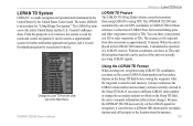
...Position coordinates can show your position as a TD or enter waypoints as TDs. After the waypoint is stored in the Setup TD field. The GPSMAP 292/298 unit automatically converts GPS...receiving LORAN signals. The LORAN system covers the entire United States and the U.S. From the perspective of a LORAN receiver..., it simulates the operation of a mariner, the system is used for inland ...
Owner's Manual - Page 110
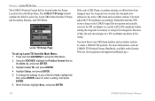
...6. Using the ROCKER, highlight the Position Format field on the LORAN signal for navigation and actually converts the ...Position Format Handbook, available at the Garmin Web site (www.garmin.com/support/userManual.jsp.)
104
GPSMAP 292/298 Owner's Manual APPENDIX > LORAN TD SYSTEM The LORAN Position... can navigate to create a LORAN TD position.
Location tab in the world. You must...
Similar Questions

My Garmin 7215 Is Not Getting A Satelite Signal Also The Garmin Radar 18' Hd Or
garmin 7215 not getting satelite signal or radar or sonar. ?
garmin 7215 not getting satelite signal or radar or sonar. ?
(Posted by Gonzalez5678 9 years ago)

Flashing Question Mark
There is a constant flashing question mark appearing on the boat symbol. What does that mean?
There is a constant flashing question mark appearing on the boat symbol. What does that mean?
(Posted by oillaw 10 years ago)


Garmin Gps 292 Can Not Recieve Satellite Signal
After winter pause my gps 292 garmin can not receive satellite signals. Two months ago I tried the f...
After winter pause my gps 292 garmin can not receive satellite signals. Two months ago I tried the f...
(Posted by helge 12 years ago)

Error In Map Position
I have a 3206 GPS chartplotter. In some locatios the boat appears in a wrong location. example: it a...
I have a 3206 GPS chartplotter. In some locatios the boat appears in a wrong location. example: it a...
(Posted by nelsonviajes 13 years ago)