Garmin GPSMAP 178C Support Question
Garmin GPSMAP 178C Support Question
Find answers below for this question about Garmin GPSMAP 178C - Marine GPS Receiver.Need a Garmin GPSMAP 178C manual? We have 1 online manual for this item!
Question posted by scosta on May 14th, 2012
Gps Signal Aquisition
Unit no longer aquires satellite gps signals
Current Answers
Related Garmin GPSMAP 178C Manual Pages
Owners Manual - Page 3
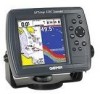
... manual is divided into two parts for your unit. This section provides you to the advanced features and operations of Garmin GPS and full-featured mapping to go to www.... Garmin (Europe) Ltd. The Garmin GPSMAP 178/178C Sounder utilizes the proven performance of the GPSMAP 178/178C Sounder.
To get the most out of the most advanced marine navigation systems available!
In the USA ...
Owners Manual - Page 4

... of this device under Part 15 regulations.
This product does not contain any interference received, including interference that interference will not occur in accordance with Industry Canada Standard RSS-... only be determined by turning the equipment off and on a different circuit from the GPS unit.
•
Consult the dealer or an experienced radio/TV technician for Class B digital...
Owners Manual - Page 7
...GPSMAP 178/178C Sounder is a powerful navigation device that can give you the information you need:
Precision Performance
• (178) 10 level grayscale FSTN display with backlighting • (178C) High-contrast, 256-color LCD screen with backlighting • 12-channel parallel receiver tracks and uses up to 12 satellites... • Built-in Worldwide marine basemap to 20 miles includes detailed...
Owners Manual - Page 8

...installing and getting started with remote antenna.
Standard Package: • GPSMAP 178/178C Sounder Unit • GA 29 Remote External Antenna and 30' cable* •... are missing, please contact your GPS unit, current user manuals and software... BlueChart Marine Data Cards, MapSource CDs, USB Data Card Programmer and Data Cards • USB Data Card Programmer • GBR 21 Beacon Receiver for...
Owners Manual - Page 9

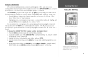
...Getting Started 1-21
Keypad Usage 1 Selecting Options 2 Entering Data 3 Initializing the Receiver/Power On 4 Tour/Backlighting 6 Simulator Mode 7 Main Pages/Map Page 8 ...Main Menu Page/Deleting Waypoints . . . . 20 Powering Off Unit 21
Section Two: Reference 22-91
Map Page 22 Cursor 23 Zooming...66
Introduction
Table of Contents
Main Menu Page 67 GPS Tab 68 Tide Tab 73 Trip Tab 74 ...
Owners Manual - Page 14

... is shipped from the factory in a location with a clear and unobstructed view of the unit.
Before you initialize, make sure the GPSMAP 178/178C Sounder unit and antenna have been correctly installed on the next page, which allows the receiver to receive satellite signals. Press and hold the POWER key until the power tone sounds and the display...
Owners Manual - Page 15
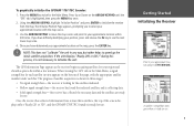
... appropriate satellite number under each satellite in three stages:
• No signal strength bars- Once the receiver has collected information from the map. Press Up or Down on the bottom of the screen displays either "Ready (2D or 3D)", and the GPSMAP 178/178C Sounder is highlighted, then press the MENU key once.
2. If the unit displays...
Owners Manual - Page 16

...LEF or RIGHT to adjust the contrast.
3. The GPSMAP 178/178C's adjustable screen backlighting is complete, press the ENTER/...receiver begins acquiring satellites. Getting Started Tour/Backlighting
A full-screen GPS Information pop-up page goes away after you press the ENTER key to acknowledge the Warning Page. If you press POWER one more time, the backlighting is displayed after the unit...
Owners Manual - Page 21
...used throughout the GPSMAP 178/178C Sounder system to provide tab style options and functions. To change the GPSMAP 178/178C Sounder position in... to select a pre-programmed tour route using the receiver's steering guidance and map displays. On the Enter ... directly from the Initialize Position Page.
11 Going to a Destination
GPS is the primary tool used to select a destination waypoint, TracBack,...
Owners Manual - Page 78
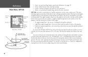
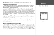
... shown in the status field). You can use .
GPS Tab- The unit then updates the position, date, and time. The progress of satellite acquisition, receiver status, and accuracy. provides a visual reference of satellite acquisition is collecting data.
• Dark/Green signal strength bars- The sky view and signal strength bars give you have a current position fix (indicated...
Owners Manual - Page 79
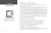
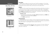
... time, the system is not fully operational. Reference Main Menu: GPS Tab
Highlight 'WAAS Off' and press ENTER to the right of the sky view.
Receiver Status and Accuracy
Receiver status is capable of receiving WAAS (Wide Area Augmentation System) satellite signals. WAAS Capability
The GPSMAP 178/178C is indicated at the top field of the page, with...
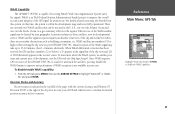
Owners Manual - Page 80
... Menu: GPS Tab
When the GPSMAP 178/178C is using a differential correction signal (either WAAS or DGPS), a "D" is displayed at the bottom of the signal strength indicator bars for the satellites that are corrected.
70
The status field shows one of the following conditions: • Looking For Satellites - the receiver is looking for any satellites. • AutoLocate - the receiver is...
Owners Manual - Page 81

... the unit if left unattended for the GPSMAP 178/178C to receive WAAS and DGPS corrections at the same time. allows the receiver to the GPS Info display. allows you to initialize the receiver graphically ...mounting of the DGPS signal being received. The GPS Info tab features an options menu that provides access to functions and features relating to locate your DGPS receiver and the distance ...
Owners Manual - Page 87
...receives the DSC signal, an alarm sounds and they immediately receive... number to the Coast Guard.
DSC is received, the mariner may then choose to navigate (Go To)... (DSC) uses marine VHF radio and Global Positioning System (GPS) technologies to control...receive a Maritime Mobile Service Identity (MMSI) number. When the Coast Guard receives the call on the unit. Any time a vessel receives...
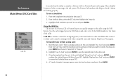
Owners Manual - Page 89

...unit and VHF radio to the Distress Call.
To notify you have a DSC-equipped chartplotter as well as a reference once it is received. Any DSC-equipped mariner (on Map'. • Create Waypoint: If you must have DSC support). When the Garmin GPSMAP 178/178C... operates similarly to send and receive NMEA data from another user's DSC capable VHF/GPS combination.
DSC Distress Call With...
Owners Manual - Page 90
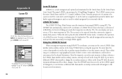
... to give the most current information, even if the unit is received. From the DSC tab of call ), and 'Delete All'. When
'calls' are received, they are updated constantly to review is removed when ...call Type, Date/Time, Position, and MMSI/Name. A user can manage up to 100 logs.
The GPS can save up to 50 calls. Reference Main Menu: DSC Tab
DSC Entry Review
DSC Log
80
DSC Call...
Owners Manual - Page 92
... To transfer data to/from the card to the unit, highlight 'Merge From Card' and press ENTER to a data card.When data is already user data on your GPS.
If transferring data from a data card: 1. Press...also has the ability to Go To the MMSI number or the Name of your GPS.
4.
Using the NAV Key The receiver of item you wish to the real system.
This is logged, press the NAV ...
Owners Manual - Page 102

... boat's superstructure, a radome antenna, or mast. If you need the appropriate fasteners and a 1" x 14-thread marine antenna mount available at most marine dealers. (If you have a GPSMAP 178/178C with harsh solvents. To install the GPS antenna:
1. Once the GPSMAP 178/178C unit has been installed, connect the cable to the mounting location of the sky in a location...
Owners Manual - Page 112
... actually receiving LORAN signals. The name LORAN is placed in the LORAN TD format mode, it always references the LORAN chain number and secondary stations currently selected in the United States by recreational vehicles. LORAN TD Feature
The LORAN TD (Time Delay) feature eases the transition from using GPS. Since the GPSMAP unit does not rely...
Owners Manual - Page 116
... Set Too High- Approaching Waypoint- Input DC voltage is Not Moving Fast Enough to Calibrate- Boat is too low for the GPSMAP 178/178C. Check for debris or boat speed is too high for the GPSMAP 178/178C. The unit has lost satellite signals. Contact your dealer or Garmin Product Support (pg.
No DGPS Position- Processor Failed...
Similar Questions

What Does Gps 178c Look Like
(Posted by realbofa 9 years ago)
Hi I Just Bay A Gps 178c Garmin And I Cant Start It. Can You Gave Mi Some Tips
(Posted by roccohristov 10 years ago)

Transfering Gps Marks
can i transfer my gps marks from my 178c garmin sounder to a computer ? cheers T
can i transfer my gps marks from my 178c garmin sounder to a computer ? cheers T
(Posted by sworldchamp 10 years ago)

I Bought A Garmin Golf Gps About 6 Months , Can Not Get A Gps Signal. Why
(Posted by eleanortyeryar12 11 years ago)

Garmin Gpsmap 172c Can't Aquire Signal
My 172c started taking longer and longer to acquire a signal last year in know good areas. This year...
My 172c started taking longer and longer to acquire a signal last year in know good areas. This year...
(Posted by kenhaslbeck 12 years ago)