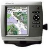
Garmin GPSMAP 540s Support Question
Garmin GPSMAP 540s Support Question
Find answers below for this question about Garmin GPSMAP 540s - Marine GPS Receiver.Need a Garmin GPSMAP 540s manual? We have 4 online manuals for this item!
Question posted by oillaw on June 23rd, 2013
Flashing Question Mark
There is a constant flashing question mark appearing on the boat symbol. What does that mean?
Current Answers


Related Garmin GPSMAP 540s Manual Pages
Quick Reference Guide - Page 1

... Search Results
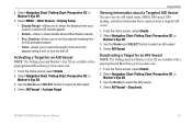
Marking a Waypoint or Man Overboard (MOB)
To mark your current location... as a waypoint or as a waypoint.
3. To create a new waypoint: 1. To move the waypoint on the Navigation chart. Select Review. (The Review button is only shown when more than one waypoint is in the vicinity.)
GPSMAP... Back to change (Name, Symbol, Depth, Water Temp,
Comment...
Quick Reference Guide - Page 2

... green bars disappear and the position icon displays a flashing question mark. Press and release the Power key. 2. Press left... 3.
Zooming In and Out on the unit, the GPS receiver must collect satellite data and establish the current location. To... , or right to view the Home screen. When the Warning screen appears, select I Agree to move through menus, highlight fields, and enter data...
Owner's Manual - Page 3
...GPSMAP® 430/430s GPSMAP 431/431s GPSMAP 530/530s GPSMAP 531/531s GPSMAP 540/540s GPSMAP 541/541s
GPSMAP 440/440s GPSMAP 441/441s GPSMAP 535/535s GPSMAP 536/536s GPSMAP 545/545s GPSMAP... Unit On or Off: page 3. • Acquiring GPS Satellite Signals: page 5. • Inserting and Removing ... select an item, small arrows (>) appear in the text. GPSMAP 400/500 Series Owner's Manual
Manual...
Owner's Manual - Page 4
...On or Off 3 Initializing Unit Settings 3 Adjusting the Backlight 4 Using the Keypad 5 Acquiring GPS Satellite Signals 5 Using Simulator Mode 6 Viewing System Information 6 Restoring the Original Factory Settings 6 ...12 Using the Split Navigation Chart 15 Using Perspective 3D 15
ii
Using Mariner's Eye 3D 16 Using Fish Eye 3D 18 Using Fishing Charts 19...GPSMAP 400/500 Series Owner's Manual
Owner's Manual - Page 7
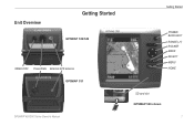
Unit Overview
Getting Started
GPSMAP 536/546
NMEA 2000 Power/Data External GPS antenna GPSMAP 531
GPSMAP 400/500 Series Owner's Manual
Getting Started
POWER/ BACKLIGHT RANGE (-/+) ROCKER MARK SELECT MENU HOME
SD card slot GPSMAP 546 shown
Owner's Manual - Page 11
... screen.
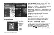
GPSMAP 400/500...GPS receiver must collect satellite data and establish the current location. Using the Keypad
POWER/ BACKLIGHT
RANGE (-/+) ROCKER MARK SELECT MENU HOME
Getting Started
POWER/BACKLIGHT-Press and hold to adjust the backlight and day and night modes. When the unit loses satellite signals, the green bars disappear and the position icon displays a flashing question mark...
Owner's Manual - Page 12
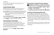
... card, open the access door and press the SD card in until it from the chartplotter.
GPSMAP 400/500 Series Owner's Manual The unit does not track satellites in again and release it to another...off for use indoors or for practice. Select Setup to navigate using simulator mode because the GPS receiver is located on Simulator mode: 1. Select Yes to restore all factory settings, or select ...
Owner's Manual - Page 23

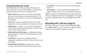
... colors on page 9. Mariner's Eye 3D (Water Hazard Colors) GPSMAP 400/500 Series Owner's Manual 17 Use the Rocker to point to view details about navaids such as seen from the Mariner's Eye 3D screen, press MENU.
Press SELECT to the navaid.
The scale ( ) temporarily appears at the bottom of the Mariner's Eye 3D screen...
Owner's Manual - Page 31
... AIS Vessel You can view the AIS signal status, MMSI, GPS speed, GPS heading, and other information that appears using a trail, or turn the trail off. Select Navigation Chart, Fishing Chart, Perspective 3D, or
Mariner's Eye 3D. 3. From the Home screen, select Charts. 2.
GPSMAP 400/500 Series Owner's Manual
25 Using Charts
Viewing Information about...
Owner's Manual - Page 39
...
When you start any type of interest (POIs) along the shore.
GPSMAP 400/500 Series Owner's Manual
33 Note: You cannot transfer BlueChart g2 Vision data from above and behind the boat for a three-dimensional navigation aid (page 16).
In addition to detailed marine charting, BlueChart g2 Vision has the following features:
•...
Owner's Manual - Page 52

...If you have Activation set to Time, select Change Time to set the number of the specified symbols.
-sounds an alarm for all fish sizes.
-sounds an alarm for medium and large fish ...unit must be on for large fish only.
46
GPSMAP 400/500 Series Owner's Manual Note: You must be receiving NMEA sonar depth data or using the system (GPS) clock. Configuring the Chartplotter
• Change Time...
Owner's Manual - Page 53
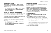
.... Select Done to accept the number. To receive fuel-level information, your chartplotter to sound an alarm when the total amount of the boat.
• If you select On, use ..., select Configure > My Boat > Keel
Offset. 2. If you are measuring up to the water line (transducer installed on or off: marine, tornado, severe
storm, flood, or flash flood.
GPSMAP 400/500 Series Owner's Manual...
Owner's Manual - Page 59
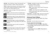
...Scheme-select White or Blue. Press SELECT. No background information appears.
GPSMAP 400/500 Series Owner's Manual
Using Sonar
• Whiteline-...mark. 3.
Appearance-customize the display of fish symbols, whiteline, and the sonar color scheme.
• Fish Symbols-set how the sonar interprets suspended targets. Suspended targets appear as symbols. Background sonar information appears...
Owner's Manual - Page 61
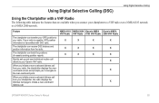
... from your Garmin VHF radio.
The chartplotter can receive DSC distress and position information from your radio.
...Radio
X
X
X
X
X
X
X
X
X
X
X
X
X
X
X
GPSMAP 400/500 Series Owner's Manual
55 Quickly set up and send individual routine call details ... call from the radio. If your radio is capable, GPS position information is transmitted with a VHF Radio
The following table...
Owner's Manual - Page 69
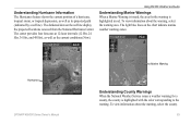
... warning. To view information about the warning, select the warning area.
The darkened dots on the chart indicate marine weather warning zones. The light blue lines on the red line display the projected locations received from the National Hurricane Center.
To view information about the warning, select the county. Understanding Hurricane Information...
Owner's Manual - Page 75
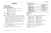
...541: 5.0 in . diagonal (12.7 cm), Full VGA display with adjustable brightness, 320 × 240 pixels.
GPSMAP 430/430s GPSMAP 530/530s GPSMAP 540/540s
GPSMAP 440/440s GPSMAP 535/535s GPSMAP 545/545s
High-sensitivity, 14 parallel channel, WAAS-capable receiver.
Case: Fully gasketed, high-impact plastic alloy, waterproof to 55ºC)
Appendix
Compass-Safe Distances:
Model...
Owner's Manual - Page 76
GPS Accuracy: Position:
Appendix
Acquisition Times: (Average acquisition times for a stationary receiver with a clear view of the sky.) GPSMAP 430/430s GPSMAP 440/440s GPSMAP 530/530s GPSMAP 535/535s GPSMAP 530/540s GPSMAP 535/545s
Warm:* Approximately 15 seconds Cold:** Approximately 45 seconds
GPSMAP 431/431s GPSMAP 441/441s GPSMAP 531/531s GPSMAP 541/541s
Warm:* Approximately 1 second Cold:**...
Owner's Manual - Page 81

...boat. In no responsibility for life", but is merely supplemental and advisory in connection with any and all safety measures required by law and your use of supported NMEA 2000 PGN numbers, see the GPSMAP...a) DISCLAIMERS. Appendix
NMEA 2000 The following GPSMAP 400 and GPSMAP 500 series chartplotters are NMEA 2000 certified and can receive data from or associated with respect thereto or ...
Owner's Manual - Page 83

...symbols 23 threats 26 AIS Alarm 49 alarms 45, 71-74 AIS 49 arrival 45 battery 46 clock 46 collision 26, 49 deep water 46 fish 46 fuel 47 GPS accuracy 46 navigation 45 safe-zone 49 shallow water 46 sonar 46 water temp 46 weather 47 Appearance..., fuel 35 go to 27 GPS 5, 41, 70 Grid (North) 42 guide to 27
H
Hazard Colors 17 heading 42 Heading Line 14 Head Up 13
GPSMAP 400/500 Series Owner's Manual 77
Owner's Manual - Page 84
...
man overboard 29, 57 map datum 42 MapSource data 37 Mariner's Eye 3D
AIS 26 MARPA 26 mariner's eye 3D colors 17 mark current location 29 MARPA threats 26 MENU key 5 messages 71
78
move a waypoint 29 My Boat 47
N
Navaid Type 14 Navigate To 11, 28, 30...speed 52 SD cards
inserting 6 removing 6 sea conditions 66 SELECT key 5 Serial Port setup 44 Service Points 12
GPSMAP 400/500 Series Owner's Manual
Similar Questions

Blurred Screen On My Garmin 172c Gpsmap
Can the screen on my Garmin 172C GPSMAP be replaced? It came with my boat in 2006. The GPS seems to ...
Can the screen on my Garmin 172C GPSMAP be replaced? It came with my boat in 2006. The GPS seems to ...
(Posted by btaylor42766 5 years ago)

How Do I Go Into Simulation Mode On A Garmin Marine Gps Modle741xs
how do I use simulation mode on a garmin 741xs marine ver
how do I use simulation mode on a garmin 741xs marine ver
(Posted by Curthupp 6 years ago)

Flashing Depth Indicator
The debth indicator on my GPS/500 series flashes a debt that is not accurate. It appears to be stuck...
The debth indicator on my GPS/500 series flashes a debt that is not accurate. It appears to be stuck...
(Posted by tim47299 10 years ago)

Why Is The Gps Tab Not Visible Anymore On Main Screen?
We lost GPS signal and now it has the triangle with a red question mark in it. Don't know how to get...
We lost GPS signal and now it has the triangle with a red question mark in it. Don't know how to get...
(Posted by Jlthomas1120 11 years ago)

Fish Finder
I have sent this unit back and they sent me a new one? but still cant get ubit to locate fish, it is...
I have sent this unit back and they sent me a new one? but still cant get ubit to locate fish, it is...
(Posted by glipsky 13 years ago)