Garmin GPSMAP 540s Support Question
Garmin GPSMAP 540s Support Question
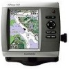
Find answers below for this question about Garmin GPSMAP 540s - Marine GPS Receiver.Need a Garmin GPSMAP 540s manual? We have 4 online manuals for this item!
Question posted by glipsky on November 3rd, 2010
Fish Finder
I have sent this unit back and they sent me a new one? but still cant get ubit to locate fish, it is good for a GPS and also for the depth is right on, but for fish finding it sucks, (several calls to Garmin ) didnt help , sick of calling them , Gulf west coast FL
Current Answers
Related Garmin GPSMAP 540s Manual Pages
Flush Mount Kit Instructions (multilingual) - Page 1
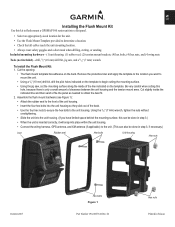
... this hole, because there is inserted correctly, it will snap into place within the unit housing.
• Connect the wiring harness, GPS antenna, and XM antenna (if applicable) to determine a location. • Check that all cables reach the unit mounting location. • Always wear safety goggles and a dust mask when drilling, cutting, or sanding. Included...
Quick Reference Guide - Page 2

... active track: From any chart except the Fish Eye 3D, select MENU > Waypoints & Tracks > Tracks > On. Turning the Unit On or Off To turn on the unit, the GPS receiver must collect satellite data and establish the current location. To turn off the unit, press and hold to start the new route.
ROCKER-Press up , down , left on...
Owner's Manual - Page 3
...Chart, and press SELECT again. Quick Links
• Turning the Unit On or Off: page 3. • Acquiring GPS Satellite Signals: page 5. • Inserting and Removing SD Cards: ...following products:
GPSMAP® 430/430s GPSMAP 431/431s GPSMAP 530/530s GPSMAP 531/531s GPSMAP 540/540s GPSMAP 541/541s
GPSMAP 440/440s GPSMAP 441/441s GPSMAP 535/535s GPSMAP 536/536s GPSMAP 545/545s GPSMAP 546/546s
...
Owner's Manual - Page 4
...Garmin iv
Getting Started 1 Unit Overview 1 Turning the Unit On or Off 3 Initializing Unit Settings 3 Adjusting the Backlight 4 Using the Keypad 5 Acquiring GPS...Perspective 3D 15
ii
Using Mariner's Eye 3D 16 Using Fish Eye 3D 18 Using Fishing Charts 19 Enabling High ... 31 Using BlueChart g2 Vision 33 Navigating with a Garmin Autopilot 33
Viewing Information 34 Viewing a Compass 34 ...
Owner's Manual - Page 9
... configure the initial settings.
AIS Receiver (is turned on your unit, you must configure the initial settings. Home Screen
Getting Started
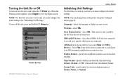
Initializing Unit Settings
The first time you turn off the unit, press and hold the Power key. Position Format-specify the coordinate system to display on your screen. GPSMAP 400/500 Series Owner's Manual...
Owner's Manual - Page 11
... Started
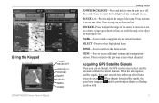
POWER/BACKLIGHT-Press and hold to turn on the unit, the GPS receiver must collect satellite data and establish the current location. Press to page up or down on lists. MARK-Press... on or off. Acquiring GPS Satellite Signals
When you turn the unit on a chart. When the unit acquires satellite signals, the signal strength bars at your current location. GPSMAP 400/500 Series Owner's ...
Owner's Manual - Page 12
... GPS receiver is located on Simulator mode: 1.
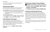
From the home screen, select Configure > System > System Information. Inserting and Removing SD Cards
Your unit supports Secure Digital (SD) cards. CAUTION: Do not try to set speed, track control, and position.
Restoring the Original Factory Settings
NOTICE: This procedure deletes any information you to another compatible Garmin unit...
Owner's Manual - Page 13

... www.garmin.com. Note: If using an SD card to transfer waypoints from any screen to return to the Home screen.
• Charts-selects Navigation, Fishing, Perspective 3D, Mariner's Eye 3D, Fish Eye 3D, and Split Navigation charts.
Press HOME from MapSource®, update to access all other vessels (page 34). • Configure-access unit...
Owner's Manual - Page 14

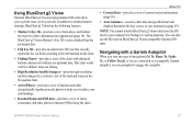
... a navigational aid. The BlueChart g2 Vision Mariner's Eye 3D is more detailed than the preloaded data. Fishing charts, Fish Eye 3D, and Mariner's Eye 3D views are available when using optional BlueChart g2 Vision preprogrammed SD cards.
• Fishing Chart-provides a view of the chart with g2 Vision GPSMAP 400/500 Series Owner's Manual Your boat...
Owner's Manual - Page 15

... navigating). GPSMAP 400/500 Series Owner's Manual
Using Charts
Data bars
• Cruising-turn the Depth, Water ...Calling) device (page 55). Navigation Chart Menu To access additional settings or options for the Navigation chart, press MENU. Select Data Bar Setup to configure the Route Leg, Next Turn, and Destination options.
• Fishing-turn the GPS Speed, GPS Heading, Depth, and GPS...
Owner's Manual - Page 17
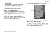
... the map pointer, you can view the distance and bearing from your current location and the map pointer's location coordinates in the lower-right corner of the map. Map pointer
To stop panning, press MENU, and then select Stop Panning. GPSMAP 400/500 Series Owner's Manual 11 Zooming In and Out on the Rocker...
Owner's Manual - Page 22
... unit must be connected to an external AIS (Automatic Identification System) or DSC (Digital Selective Calling) device. Other Vessels-view information about other vessels.
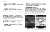
This view is helpful when navigating tricky shoals, reefs, bridges, or channels, and is connected to a weather module and you have been saved. Mariner's Eye 3D
Navigation Chart
16
GPSMAP...
Owner's Manual - Page 27

.../Sonar screen, like the Sonar screen, is only available when using a sonar-capable unit with the pointer, and select Aerial Photo or Review. icon
Using Charts
Detailed Road...Mariner's Eye 3D, or Fish Eye 3D and sonar at a
glance. These detailed icons
show the speed and direction of interest (POI) data, which includes highly detailed coastal roads and POIs such as highlighted arrows.
GPSMAP...
Owner's Manual - Page 31
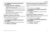
... MMSI, GPS speed, GPS heading, and other information that appears using a trail, or turn the trail off. Deactivating a Target for an AIS Vessel Note: The Fishing chart and Mariner's Eye ... the distance from your location in which AIS vessels appear.
• Details-hides or shows details about a targeted AIS vessel.
1. Select Navigation Chart, Fishing Chart, Perspective 3D, or
Mariner's Eye 3D. 3....
Owner's Manual - Page 39
..., Guide To, or Follow Track), if you are connected to your unit. This chart works well for offshore deep-sea fishing.
• High Resolution Satellite Imagery-provides high-resolution satellite images for a three-dimensional navigation aid (page 16).
The BlueChart g2 Vision Mariner's Eye 3D is more detailed than the preloaded data.
•...
Owner's Manual - Page 52

...GPS location accuracy falls outside the specified value.
Battery-set the distance before arrival that is 2°F (1.1°C) above or below the specified temperature. Deep Water-set an alarm using a Garmin...System.
The unit must be on for large fish only.
46
GPSMAP 400/500 Series Owner's Manual Note: You must be receiving NMEA sonar depth data or using the system (GPS) clock. ...
Owner's Manual - Page 56
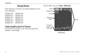
Depth Temperature
Speed
Suspended targets
Transducer frequency or beam width
Full Screen
Range
50
GPSMAP 400/500 Series Owner's Manual
From the Home screen, select Sonar > Full Screen. Using Sonar
Using Sonar
When connected to a transducer, the following chartplotters can be used as fishfinders:
GPSMAP 430s GPSMAP 431s GPSMAP 530s GPSMAP 531s GPSMAP 540s GPSMAP 541s
GPSMAP 440s GPSMAP ...
Owner's Manual - Page 75
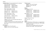
... in. (65) cm
30 in. (75 cm)
38 in . GPSMAP 431/431s GPSMAP 441/441s GPSMAP 531/531s GPSMAP 541/541s
High-sensitivity, 12 parallel channel, WAAS-capable receiver.
GPSMAP 530/531/540/541: 5.0 in . GPSMAP 535/536/545/546: 5.0 in .
GPSMAP 430/430s GPSMAP 530/530s GPSMAP 540/540s
GPSMAP 440/440s GPSMAP 535/535s GPSMAP 545/545s
High-sensitivity, 14 parallel channel, WAAS-capable...
Owner's Manual - Page 76
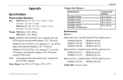
GPS Accuracy: Position: Appendix
Acquisition Times: (Average acquisition times for a stationary receiver with a clear view of the sky.) GPSMAP 430/430s GPSMAP 440/440s GPSMAP 530/530s GPSMAP 535/535s GPSMAP 530/540s GPSMAP 535/545s
Warm:* Approximately 15 seconds Cold:** Approximately 45 seconds
GPSMAP 431/431s GPSMAP 441/441s GPSMAP 531/531s GPSMAP 541/541s
Warm:* Approximately 1 second Cold:** ...
Owner's Manual - Page 83

... 18 fishing 19 mariner's eye 3D 16 navigation 8 settings 12 cleaning the unit 74 Clear User Data 37 collision alarm 26, 49 colors, hazard 17 Color Scheme 53 Communications 44 Compass 34 compass rose 12 contact information, Garmin iv
course up 13 current stations 36 customizing chart settings 12
D
dashboard 34 Data Bars
fish eye...
Similar Questions

How Do I Go Into Simulation Mode On A Garmin Marine Gps Modle741xs
how do I use simulation mode on a garmin 741xs marine ver
how do I use simulation mode on a garmin 741xs marine ver
(Posted by Curthupp 6 years ago)

Flashing Depth Indicator
The debth indicator on my GPS/500 series flashes a debt that is not accurate. It appears to be stuck...
The debth indicator on my GPS/500 series flashes a debt that is not accurate. It appears to be stuck...
(Posted by tim47299 10 years ago)

Flashing Question Mark
There is a constant flashing question mark appearing on the boat symbol. What does that mean?
There is a constant flashing question mark appearing on the boat symbol. What does that mean?
(Posted by oillaw 10 years ago)

541s Marine Gps. Depth Not Reading Out.
Depth has been working since installed. Now blank. Is there an on off control for this that may have...
Depth has been working since installed. Now blank. Is there an on off control for this that may have...
(Posted by therad50 11 years ago)

Trans Data Between Two Units
Bought 2 541S units. Can I trans data fish finder to GPS. I have a 182C ( Chart/Ploter ) and 340C F...
Bought 2 541S units. Can I trans data fish finder to GPS. I have a 182C ( Chart/Ploter ) and 340C F...
(Posted by greyzephyr1 12 years ago)