
GPS 12, 12XL, 48, 80 Addendum
Page 1
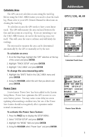
... power. To change the area measuring units: 1. Power Save optimizes the GPS receiver to measure the area can now calculate an area using the CALC AREA feature you need to clear the track log. The GPS will falsify the readings. Highlight 'TRACK SETUP' and press ENTER. 3. ...You may notice some delay in a track log. To calculate an area the GPS needs to your GPS Owner's Manual for directions on clearing the track log. Addendum GPS12,12XL, 48, 80 Calculate Track Area Power Save Mode 1 Highlight 'CALC AREA' and press ENTER. To calculate ...
... power. To change the area measuring units: 1. Power Save optimizes the GPS receiver to measure the area can now calculate an area using the CALC AREA feature you need to clear the track log. The GPS will falsify the readings. Highlight 'TRACK SETUP' and press ENTER. 3. ...You may notice some delay in a track log. To calculate an area the GPS needs to your GPS Owner's Manual for directions on clearing the track log. Addendum GPS12,12XL, 48, 80 Calculate Track Area Power Save Mode 1 Highlight 'CALC AREA' and press ENTER. To calculate ...
Owner's Manual (Software Version 2.00-3.62)
Page 2
...manual may not be reproduced or transmitted in any form or by any means including photocopying and recording, for any person or organization of GARMIN. C - No part of this document is subject to change or improve its products and to make changes in Taiwan Software Version 3.0 or above © 1997 GARMIN... Corporation 1200 E. 151st Street, Olathe, Kansas 66062 USA Tel: 913-397-8200 or 800-800-1020 Fax: 913-397-8282 GARMIN (Europe) Ltd. GARMIN reserves the right to notify any purpose without the express ...
...manual may not be reproduced or transmitted in any form or by any means including photocopying and recording, for any person or organization of GARMIN. C - No part of this document is subject to change or improve its products and to make changes in Taiwan Software Version 3.0 or above © 1997 GARMIN... Corporation 1200 E. 151st Street, Olathe, Kansas 66062 USA Tel: 913-397-8200 or 800-800-1020 Fax: 913-397-8282 GARMIN (Europe) Ltd. GARMIN reserves the right to notify any purpose without the express ...
Owner's Manual (Software Version 2.00-3.62)
Page 3
...; Quick Reference Guide • 4 AA Batteries See your outdoor gear. The GPS 12XL represents GARMIN's continuing commitment to see that your GARMIN GPS 12XL package includes the following items. If you are missing any parts, please contact your convenience: Introduction gives a quick overview of the manual and contains the table of contents and the glossary of navigational...
...; Quick Reference Guide • 4 AA Batteries See your outdoor gear. The GPS 12XL represents GARMIN's continuing commitment to see that your GARMIN GPS 12XL package includes the following items. If you are missing any parts, please contact your convenience: Introduction gives a quick overview of the manual and contains the table of contents and the glossary of navigational...

Owner's Manual (Software Version 2.00-3.62)
Page 4
...maintenance. Operation is a precision electronic NAVigation AID (NAVAID), any interference received, including interference that interference will not occur in accordance with all available navigation sources including the information from the GPS 12XL to actual use . For safety, always resolve any user-serviceable parts... has been tested for compliance with the instructions, may cause undesired operation. Use the GPS 12XL at your authority to operate this Operator's Manual and thoroughly practice operation using the simulator mode prior to all necessary FCC standards.
...maintenance. Operation is a precision electronic NAVigation AID (NAVAID), any interference received, including interference that interference will not occur in accordance with all available navigation sources including the information from the GPS 12XL to actual use . For safety, always resolve any user-serviceable parts... has been tested for compliance with the instructions, may cause undesired operation. Use the GPS 12XL at your authority to operate this Operator's Manual and thoroughly practice operation using the simulator mode prior to all necessary FCC standards.
Owner's Manual (Software Version 2.00-3.62)
Page 6
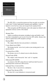
...navigation and GPS definitions used in the manual are off a desired course in the world. Desired Track (DTK) The compass course between the "from " position (your present position. INTRODUCTION Glossary The GPS 12XL is ...transmitted to a destination. Estimated Time Enroute (ETE) The time left to your destination at your arrival at a destination. Almanac data must be helpful to GPS receivers...
...navigation and GPS definitions used in the manual are off a desired course in the world. Desired Track (DTK) The compass course between the "from " position (your present position. INTRODUCTION Glossary The GPS 12XL is ...transmitted to a destination. Estimated Time Enroute (ETE) The time left to your destination at your arrival at a destination. Almanac data must be helpful to GPS receivers...
Owner's Manual (Software Version 2.00-3.62)
Page 12
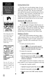
...Started Tour Now that you've seen the primary pages, let's get started by the Position Page. Press B until the receiver turns on the map. Before we can use our GPS 12XL to guide us somewhere, we have been changed , the pictures and descriptions you see on and that none of the ...factory settings ( units of the page. Highlight the name field, and press E. 2. Enter the waypoint name 'HOME', and press E. (See pg. 9 for the new waypoint in this manual may...
...Started Tour Now that you've seen the primary pages, let's get started by the Position Page. Press B until the receiver turns on the map. Before we can use our GPS 12XL to guide us somewhere, we have been changed , the pictures and descriptions you see on and that none of the ...factory settings ( units of the page. Highlight the name field, and press E. 2. Enter the waypoint name 'HOME', and press E. (See pg. 9 for the new waypoint in this manual may...
Owner's Manual (Software Version 2.00-3.62)
Page 20
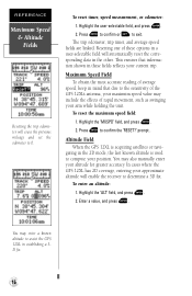
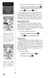
...confirm or Q to confirm the 'RESET?' prompt . Altitude Field When the GPS 12XL is acquiring satellites or navigating in the 2D mode, the last known altitude is used to 0. You may also manually enter your position. REFERENCE Maximum Speed & Altitude Fields Resetting the trip odometer will...and press E. 2. To reset timer, speed measurement, or odometer: 1. In cases where the GPS 12XL has 2D coverage, entering your approximate altitude will enable the receiver to assist the GPS 12XL in a user-selectable field will erase the previous mileage and set the odometer to compute your ...
...confirm or Q to confirm the 'RESET?' prompt . Altitude Field When the GPS 12XL is acquiring satellites or navigating in the 2D mode, the last known altitude is used to 0. You may also manually enter your position. REFERENCE Maximum Speed & Altitude Fields Resetting the trip odometer will...and press E. 2. To reset timer, speed measurement, or odometer: 1. In cases where the GPS 12XL has 2D coverage, entering your approximate altitude will enable the receiver to assist the GPS 12XL in a user-selectable field will erase the previous mileage and set the odometer to compute your ...
Owner's Manual (Software Version 2.00-3.62)
Page 21
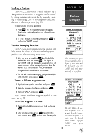
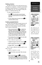
...the value reflecting estimated accuracy of selective availability upon position error when marking a waypoint. 1. The GPS 12XL will rapidly change before it stabilizes on one number. 2. Marking a Position The GPS 12XL allows you to mark and store up to route number' field, and press E. 2. To ... of the averaged position. Position Averaging Function The GPS 12XL positioning averaging function will appear, showing the captured position and a default threedigit name. 2. The unit will be entered by taking an instant electronic fix, by manually entering coordinates (pg. 20), or by using...
...the value reflecting estimated accuracy of selective availability upon position error when marking a waypoint. 1. The GPS 12XL will rapidly change before it stabilizes on one number. 2. Marking a Position The GPS 12XL allows you to mark and store up to route number' field, and press E. 2. To ... of the averaged position. Position Averaging Function The GPS 12XL positioning averaging function will appear, showing the captured position and a default threedigit name. 2. The unit will be entered by taking an instant electronic fix, by manually entering coordinates (pg. 20), or by using...
Owner's Manual (Software Version 2.00-3.62)
Page 24
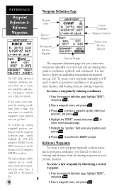
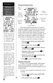
... definition page lets you create new waypoints manually or review and edit an existing waypoint's coordinates, symbols, and comments. Press E to select a waypoint symbol, make your present position. REFERENCE Waypoint Definition & Reference Waypoints The GPS 12XL's advanced waypoint planning features allow you to...approximate distance and bearing from an existing waypoint. Press E to confirm. To create a new waypoint manually, you get there. Reference Waypoints To create a new waypoint manually without ever setting foot outside. Use the LEFT arrow key to set the distance to 0.00, and...
... definition page lets you create new waypoints manually or review and edit an existing waypoint's coordinates, symbols, and comments. Press E to select a waypoint symbol, make your present position. REFERENCE Waypoint Definition & Reference Waypoints The GPS 12XL's advanced waypoint planning features allow you to...approximate distance and bearing from an existing waypoint. Press E to confirm. To create a new waypoint manually, you get there. Reference Waypoints To create a new waypoint manually without ever setting foot outside. Use the LEFT arrow key to set the distance to 0.00, and...
Owner's Manual (Software Version 2.00-3.62)
Page 26
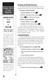
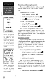
..., move to that matches the character or characters you have entered to the next character position as needed. 4. Note: The GPS 12XL's waypoint scanning feature will automatically display the first numerical or alphabetical match of the character you 'll be given a "Route Waypoint... up to quickly save waypoints by pressing MARK and then ENTER, thus assigning a default name. Scanning Waypoints As you manually enter a waypoint's name, the GPS 12XL's waypoint scanning feature will offer the first waypoint that point. Scroll through the waypoints. REFERENCE Rename, Delete & Scan Waypoints...
..., move to that matches the character or characters you have entered to the next character position as needed. 4. Note: The GPS 12XL's waypoint scanning feature will automatically display the first numerical or alphabetical match of the character you 'll be given a "Route Waypoint... up to quickly save waypoints by pressing MARK and then ENTER, thus assigning a default name. Scanning Waypoints As you manually enter a waypoint's name, the GPS 12XL's waypoint scanning feature will offer the first waypoint that point. Scroll through the waypoints. REFERENCE Rename, Delete & Scan Waypoints...
Owner's Manual (Software Version 2.00-3.62)
Page 28
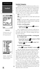
.... 24 TracBack Navigation GARMIN's patented TracBack feature ...E. Press G, highlight 'TRACBACK?', and press E. Once the TracBack function has been activated, the GPS 12XL will appear, showing a route from a route, but only if the route is activated, it... The active route page will take the track log currently stored in the receiver. Highlight 'TRACBACK?' Three track recording options are available: Off-no plot ... option: 1. This feature eliminates the need to mark waypoints along the way and manually create and activate a route back to where you to quickly retrace your trip....
.... 24 TracBack Navigation GARMIN's patented TracBack feature ...E. Press G, highlight 'TRACBACK?', and press E. Once the TracBack function has been activated, the GPS 12XL will appear, showing a route from a route, but only if the route is activated, it... The active route page will take the track log currently stored in the receiver. Highlight 'TRACBACK?' Three track recording options are available: Off-no plot ... option: 1. This feature eliminates the need to mark waypoints along the way and manually create and activate a route back to where you to quickly retrace your trip....

Owner's Manual (Software Version 4.0 and above)
Page 2
... to change without the expressed permission of GARMIN. GARMIN, Personal Navigator, AutoLocate, TracBack, and PhaseTrac12 are all trademarks of GARMIN. February 1998 - Part Number 190-00134-10 Rev. Information in the content without obligation to make changes in this manual may not be reproduced or transmitted in ...Taiwan. No part of such changes. A - Tel: 011-886-02-917-3773 Fax: 011-886-02-917-1758 Web Site Address: www.garmin.com All rights reserved. Printed in any...
... to change without the expressed permission of GARMIN. GARMIN, Personal Navigator, AutoLocate, TracBack, and PhaseTrac12 are all trademarks of GARMIN. February 1998 - Part Number 190-00134-10 Rev. Information in the content without obligation to make changes in this manual may not be reproduced or transmitted in ...Taiwan. No part of such changes. A - Tel: 011-886-02-917-3773 Fax: 011-886-02-917-1758 Web Site Address: www.garmin.com All rights reserved. Printed in any...
Owner's Manual (Software Version 4.0 and above)
Page 3
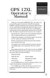
... the unit and provides a quick-start orientation to the GPS 12XL. The GPS 12XL represents GARMIN's continuing commitment to provide quality navigation information in order to understand the operating features of the GPS 12XL. i INTRODUCTION GPS 12XL Operator's Manual Packing List Thank you for choosing the GARMIN GPS 12XL -the smallest, easiest-to-use GPS navigator for accessories including our PC kit, swivel mounts...
... the unit and provides a quick-start orientation to the GPS 12XL. The GPS 12XL represents GARMIN's continuing commitment to provide quality navigation information in order to understand the operating features of the GPS 12XL. i INTRODUCTION GPS 12XL Operator's Manual Packing List Thank you for choosing the GARMIN GPS 12XL -the smallest, easiest-to-use GPS navigator for accessories including our PC kit, swivel mounts...
Owner's Manual (Software Version 4.0 and above)
Page 4
...Although the GPS 12XL is a precision electronic NAVigation AID (NAVAID), any NAVAID can be made by relocating the equipment or connecting the equipment to the following conditions: (1) This device cannot cause harmful interference, and (2) this device must accept any interference received, including...other NAVAIDs, visual sightings, maps, etc. The GPS 12XL does not contain any discrepancies before continuing navigation. However, there is no guarantee that may cause harmful interference to all aspects of this Operator's Manual and thoroughly practice operation using the simulator mode ...
...Although the GPS 12XL is a precision electronic NAVigation AID (NAVAID), any NAVAID can be made by relocating the equipment or connecting the equipment to the following conditions: (1) This device cannot cause harmful interference, and (2) this device must accept any interference received, including...other NAVAIDs, visual sightings, maps, etc. The GPS 12XL does not contain any discrepancies before continuing navigation. However, there is no guarantee that may cause harmful interference to all aspects of this Operator's Manual and thoroughly practice operation using the simulator mode ...
Owner's Manual (Software Version 4.0 and above)
Page 6
... your present speed. 2 Estimated Time of Arrival (ETA) The time of day of the GPS system that can begin. Almanac Data Satellite constellation information (including location and health of the manual. INTRODUCTION Glossary The GPS 12XL is transmitted to your receiver from your destination at a destination. To better understand its operation and capabilities, it may...
... your present speed. 2 Estimated Time of Arrival (ETA) The time of day of the GPS system that can begin. Almanac Data Satellite constellation information (including location and health of the manual. INTRODUCTION Glossary The GPS 12XL is transmitted to your receiver from your destination at a destination. To better understand its operation and capabilities, it may...
Owner's Manual (Software Version 4.0 and above)
Page 12
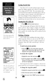
...on and that you the basics about marking and going to guide us somewhere, we have been changed . Press until the receiver turns on the map. Turning the GPS 12XL On 1. The mark position page will appear, with a default three-digit name for easy waypoint recognition on . Enter the ... will be assigned a custom waypoint symbol for the new waypoint in this manual may also be shown while the unit conducts a self test. If these settings have to mark a position as a waypoint. (Your GPS 12XL can use our GPS 12XL to places called waypoints. Highlight the name field, and press . 2....
...on and that you the basics about marking and going to guide us somewhere, we have been changed . Press until the receiver turns on the map. Turning the GPS 12XL On 1. The mark position page will appear, with a default three-digit name for easy waypoint recognition on . Enter the ... will be assigned a custom waypoint symbol for the new waypoint in this manual may also be shown while the unit conducts a self test. If these settings have to mark a position as a waypoint. (Your GPS 12XL can use our GPS 12XL to places called waypoints. Highlight the name field, and press . 2....
Owner's Manual (Software Version 4.0 and above)
Page 20
... position fix. In cases where the GPS 12XL has 2D coverage, entering your approximate altitude will also be reset to the sensitivity of the GPS 12XL's antenna, your altitude for greater accuracy. You may also manually enter your maximum speed value may include... the effects of rapid movement, such as a selectable option (see left). 2. Average speed, maximum speed and timer readouts will enable the receiver to assist the GPS 12XL...
... position fix. In cases where the GPS 12XL has 2D coverage, entering your approximate altitude will also be reset to the sensitivity of the GPS 12XL's antenna, your altitude for greater accuracy. You may also manually enter your maximum speed value may include... the effects of rapid movement, such as a selectable option (see left). 2. Average speed, maximum speed and timer readouts will enable the receiver to assist the GPS 12XL...
Owner's Manual (Software Version 4.0 and above)
Page 21
...The waypoint will be added to a known position (pg. 20). field will save the waypoint. The GPS 12XL will automatically be entered by taking an instant electronic fix, by manually entering coordinates (pg. 20), or by using the bearing and distance to the end of the averaged ... prompt. After you to mark and store up to stabilize over time. 2. Highlight the waypoint name field, and press . 2. Marking a Position The GPS 12XL allows you have highlighted 'SAVE?' A waypoint can be highlighted. To mark your present position: 1. To save a default name and symbol, press to route...
...The waypoint will be added to a known position (pg. 20). field will save the waypoint. The GPS 12XL will automatically be entered by taking an instant electronic fix, by manually entering coordinates (pg. 20), or by using the bearing and distance to the end of the averaged ... prompt. After you to mark and store up to stabilize over time. 2. Highlight the waypoint name field, and press . 2. Marking a Position The GPS 12XL allows you have highlighted 'SAVE?' A waypoint can be highlighted. To mark your present position: 1. To save a default name and symbol, press to route...
Owner's Manual (Software Version 4.0 and above)
Page 24
...To create a waypoint by referencing a stored waypoint: 1. Press to confirm. REFERENCE Waypoint Definition & Reference Waypoints The GPS 12XL's advanced waypoint planning features allow you to create new waypoints and practice navigation without knowing its position coordinates, you'll ... an existing waypoint's coordinates, symbols, and comments. To create a new waypoint by entering coordinates: 1. To create a new waypoint manually, you'll need to enter its approximate distance and bearing from Reference Waypoint Function Prompts The waypoint definition page lets you must have ...
...To create a waypoint by referencing a stored waypoint: 1. Press to confirm. REFERENCE Waypoint Definition & Reference Waypoints The GPS 12XL's advanced waypoint planning features allow you to create new waypoints and practice navigation without knowing its position coordinates, you'll ... an existing waypoint's coordinates, symbols, and comments. To create a new waypoint by entering coordinates: 1. To create a new waypoint manually, you'll need to enter its approximate distance and bearing from Reference Waypoint Function Prompts The waypoint definition page lets you must have ...
Owner's Manual (Software Version 4.0 and above)
Page 26
... delete a waypoint that's part of a route, you have entered up to that point. Scanning Waypoints As you manually enter a waypoint's name, the GPS 12XL's waypoint scanning feature will offer the first waypoint that matches the character or characters you 'll be given a "Route... If you instant access to confirm the 'Yes?' Scanning waypoints from a waypoint field: 1. To delete a stored waypoint: 1. Note: The GPS 12XL's waypoint scanning feature will automatically display the first numerical or alphabetical match of the keypad to always enter a waypoint's complete name. To scan...
... delete a waypoint that's part of a route, you have entered up to that point. Scanning Waypoints As you manually enter a waypoint's name, the GPS 12XL's waypoint scanning feature will offer the first waypoint that matches the character or characters you 'll be given a "Route... If you instant access to confirm the 'Yes?' Scanning waypoints from a waypoint field: 1. To delete a stored waypoint: 1. Note: The GPS 12XL's waypoint scanning feature will automatically display the first numerical or alphabetical match of the keypad to always enter a waypoint's complete name. To scan...


