
GPS 12, 12XL, 48, 80 Addendum
Page 1
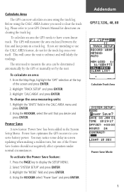
... the top of the Power Save feature should not negatively affect operation under normal circumstances. Power Save optimizes the GPS receiver to measure the area can now calculate an area using the CALC AREA feature you are intending to clear the track log. You may notice some delay in a ... SETUP' and press ENTER 3. Addendum GPS12,12XL, 48, 80 Calculate Track Area Power Save Mode 1 Highlight the 'UNITS' field in the System Setup Menu. Highlight the 'MODE' field and press ENTER. 4. To calculate an area the GPS needs to your GPS Owner's Manual for directions on clearing the...
... the top of the Power Save feature should not negatively affect operation under normal circumstances. Power Save optimizes the GPS receiver to measure the area can now calculate an area using the CALC AREA feature you are intending to clear the track log. You may notice some delay in a ... SETUP' and press ENTER 3. Addendum GPS12,12XL, 48, 80 Calculate Track Area Power Save Mode 1 Highlight the 'UNITS' field in the System Setup Menu. Highlight the 'MODE' field and press ENTER. 4. To calculate an area the GPS needs to your GPS Owner's Manual for directions on clearing the...
Owner's Manual (Software Version 2.00-3.62)
Page 2
... subject to notify any purpose without the expressed permission of such changes. GARMIN, Personal Navigator, AutoLocate, TracBack, and PhaseTrac12 are all trademarks of GARMIN Corporation and may be used without the express written permission of GARMIN. C - Software Version 3.0 or above © 1997 GARMIN Corporation 1200 E. 151st Street, Olathe, Kansas 66062 USA Tel: 913-397-8200...
... subject to notify any purpose without the expressed permission of such changes. GARMIN, Personal Navigator, AutoLocate, TracBack, and PhaseTrac12 are all trademarks of GARMIN Corporation and may be used without the express written permission of GARMIN. C - Software Version 3.0 or above © 1997 GARMIN Corporation 1200 E. 151st Street, Olathe, Kansas 66062 USA Tel: 913-397-8200...
Owner's Manual (Software Version 2.00-3.62)
Page 3
... unit and provides a quick-start orientation to understand the operating features of the GPS 12XL by topic. The Appendix section contains initialization instructions and items with your GPS, check to see that your GARMIN GPS 12XL package includes the following items. If you to -use GPS navigator for accessories including our PC kit, swivel mounts, external antennas, and...
... unit and provides a quick-start orientation to understand the operating features of the GPS 12XL by topic. The Appendix section contains initialization instructions and items with your GPS, check to see that your GARMIN GPS 12XL package includes the following items. If you to -use GPS navigator for accessories including our PC kit, swivel mounts, external antennas, and...

Owner's Manual (Software Version 2.00-3.62)
Page 4
...this device under Part 15 regulations. Operation is no guarantee that may cause harmful interference to radio communications. The GPS 12XL does not contain any interference received, including interference that interference will not occur in accordance with all necessary FCC standards. The system is solely responsible...which is subject to changes which could void your warranty and your own risk. It has been tested for home or office use. Unauthorized repairs or modifications could affect the accuracy and performance of the United States, which can be determined by turning the ...
...this device under Part 15 regulations. Operation is no guarantee that may cause harmful interference to radio communications. The GPS 12XL does not contain any interference received, including interference that interference will not occur in accordance with all necessary FCC standards. The system is solely responsible...which is subject to changes which could void your warranty and your own risk. It has been tested for home or office use. Unauthorized repairs or modifications could affect the accuracy and performance of the United States, which can be determined by turning the ...
Owner's Manual (Software Version 2.00-3.62)
Page 5
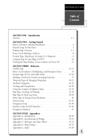
... Page & User Selectable Fields 15-16 Marking a Position & Position Averaging Function 17 Waypoint Pages & Managing Waypoints 18-23 TracBack Navigation 24-25 Creating and Using Routes 26-30 Using the Compass & Highway Pages 31-34 Map Page, Zooming, & Panning 35-38 Map Page & Track Log Setup 38-40 Menu Page & Distance/Sun...
... Page & User Selectable Fields 15-16 Marking a Position & Position Averaging Function 17 Waypoint Pages & Managing Waypoints 18-23 TracBack Navigation 24-25 Creating and Using Routes 26-30 Using the Compass & Highway Pages 31-34 Map Page, Zooming, & Panning 35-38 Map Page & Track Log Setup 38-40 Menu Page & Distance/Sun...
Owner's Manual (Software Version 2.00-3.62)
Page 6
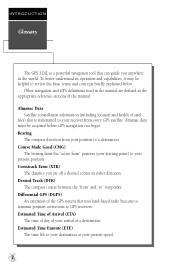
...GPS 12XL is transmitted to your position to a destination. Estimated Time of Arrival (ETA) The time of day of the manual. Almanac data must be helpful to review the basic terms and concepts briefly explained below. Desired Track (DTK) The compass course between the "from " position (your starting point) to GPS receivers... to transmit position corrections to your present speed. 2 Bearing The compass direction from your receiver from every GPS satellite. Other navigation and GPS definitions used in the manual are off a desired course in either direction. Course Made Good (CMG...
...GPS 12XL is transmitted to your position to a destination. Estimated Time of Arrival (ETA) The time of day of the manual. Almanac data must be helpful to review the basic terms and concepts briefly explained below. Desired Track (DTK) The compass course between the "from " position (your starting point) to GPS receivers... to transmit position corrections to your present speed. 2 Bearing The compass direction from your receiver from every GPS satellite. Other navigation and GPS definitions used in the manual are off a desired course in either direction. Course Made Good (CMG...
Owner's Manual (Software Version 2.00-3.62)
Page 7
... zones. Position An exact, unique location based on a flat surface, using square zones for position measurements. Universal Transverse Mercator (UTM) A grid coordinate system that passes through the north and south poles. Velocity Made Good (VMG) The speed you are traveling in the receiver's memory. 3 Navigation The process of the destination. INTRODUCTION Glossary...
... zones. Position An exact, unique location based on a flat surface, using square zones for position measurements. Universal Transverse Mercator (UTM) A grid coordinate system that passes through the north and south poles. Velocity Made Good (VMG) The speed you are traveling in the receiver's memory. 3 Navigation The process of the destination. INTRODUCTION Glossary...
Owner's Manual (Software Version 2.00-3.62)
Page 8
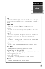
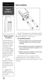
...receiving capabilities of the unit by plugging it into position. Contact your GARMIN dealer for remote antennas and accessories. Remove the battery cover by turning the thumb loop 1/4 turn counterclockwise. 2. INTRODUCTION Battery Installation Battery Installation Remote Antenna Installation An optional remote antenna may not be used with the GPS 12XL. The GPS 12XL... magnifying weaker signals which are installed at the bottom of use . You may find that lithium batteries provide longer life in antenna may be able to use . These batteries provide up to a variety of the ...
...receiving capabilities of the unit by plugging it into position. Contact your GARMIN dealer for remote antennas and accessories. Remove the battery cover by turning the thumb loop 1/4 turn counterclockwise. 2. INTRODUCTION Battery Installation Battery Installation Remote Antenna Installation An optional remote antenna may not be used with the GPS 12XL. The GPS 12XL... magnifying weaker signals which are installed at the bottom of use . You may find that lithium batteries provide longer life in antenna may be able to use . These batteries provide up to a variety of the ...

Owner's Manual (Software Version 2.00-3.62)
Page 9
... position page. P Scrolls through the main data pages in sequence and returns display from field to a primary page. sor forward or backward along the line. Use the U and D keys to move the cur- use the L and R keys to select letters, numbers, and menu options; DATA ENTRY The arrow keypad is... used for GOTO operation. E Confirms data entry and activates highlighted fields to field. UD Selects alphanumerical characters and menu choices and moves the field highlight from a ...
... position page. P Scrolls through the main data pages in sequence and returns display from field to a primary page. sor forward or backward along the line. Use the U and D keys to move the cur- use the L and R keys to select letters, numbers, and menu options; DATA ENTRY The arrow keypad is... used for GOTO operation. E Confirms data entry and activates highlighted fields to field. UD Selects alphanumerical characters and menu choices and moves the field highlight from a ...
Owner's Manual (Software Version 2.00-3.62)
Page 10
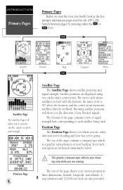
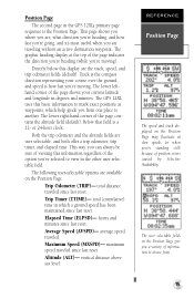
...186; above the horizon; and the center point represents satellites directly overhead. A trip odometer and 12/24-hour clock are displayed using two circles and a center point. The outer circle shows satellites on level with the horizon; Position Page The Position Page shows ...you 're going. J Satellite Position Map Compass Menu Q Satellite Page The Satellite Page will show you to each satellite being used for the GPS 12XL. Position Page 6 Satellite Page The Satellite Page shows satellite positions and signal strength. The graphic compass tape reflects your current position...
...186; above the horizon; and the center point represents satellites directly overhead. A trip odometer and 12/24-hour clock are displayed using two circles and a center point. The outer circle shows satellites on level with the horizon; Position Page The Position Page shows ...you 're going. J Satellite Position Map Compass Menu Q Satellite Page The Satellite Page will show you to each satellite being used for the GPS 12XL. Position Page 6 Satellite Page The Satellite Page shows satellite positions and signal strength. The graphic compass tape reflects your current position...
Owner's Manual (Software Version 2.00-3.62)
Page 11
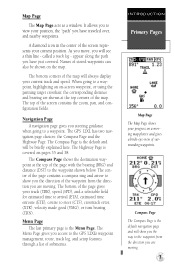
... (TRK), speed (SPD), and a selectable field for estimated time to arrival (ETA), estimated time enroute (ETE), course to a waypoint. The GPS 12XL has two navigation page choices: the Compass Page and the Highway Page. The bottom of submenus. INTRODUCTION Primary Pages Map Page The Map Page shows...Compass Page is covered on a moving . 7 The Highway Page is the default navigation page and will be shown on -screen waypoint, or using the panning target crosshair, the corresponding distance and bearing are shown at the top corners of the screen contains the zoom, pan, and configuration...
... (TRK), speed (SPD), and a selectable field for estimated time to arrival (ETA), estimated time enroute (ETE), course to a waypoint. The GPS 12XL has two navigation page choices: the Compass Page and the Highway Page. The bottom of submenus. INTRODUCTION Primary Pages Map Page The Map Page shows...Compass Page is covered on a moving . 7 The Highway Page is the default navigation page and will be shown on -screen waypoint, or using the panning target crosshair, the corresponding distance and bearing are shown at the top corners of the screen contains the zoom, pan, and configuration...
Owner's Manual (Software Version 2.00-3.62)
Page 12
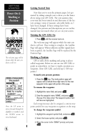
...Select the house symbol, and press E. 3. prompt, and press E. Press B until the receiver turns on your GPS 12XL. When sufficient satellite signals have to mark a position as a waypoint. (Your GPS 12XL can use our GPS 12XL to show you 've seen the primary pages, let's get started by taking a simple ...and press E. (See pg. 9 for data entry.) The waypoint symbol field will appear while the unit conducts a self test. Turning the GPS 12XL On 1. GETTING STARTED Power On & Marking a Position The welcome page will be assigned a custom waypoint symbol for easy waypoint recognition on ...
...Select the house symbol, and press E. 3. prompt, and press E. Press B until the receiver turns on your GPS 12XL. When sufficient satellite signals have to mark a position as a waypoint. (Your GPS 12XL can use our GPS 12XL to show you 've seen the primary pages, let's get started by taking a simple ...and press E. (See pg. 9 for data entry.) The waypoint symbol field will appear while the unit conducts a self test. Turning the GPS 12XL On 1. GETTING STARTED Power On & Marking a Position The welcome page will be assigned a custom waypoint symbol for easy waypoint recognition on ...
Owner's Manual (Software Version 2.00-3.62)
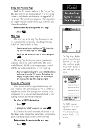
Page 13
...the time of your position are moving to the next page: 1. The house symbol labeled 'HOME' is the waypoint you are displayed in the GPS 12XL's memory. 9 Notice how the display changes, always keeping the direction you created and the line connecting the two is the Map Page.To ensure...: 1. The GOTO waypoint page allows you are moving to a Waypoint Once you've stored a waypoint in the center of the screen. Using the Position Page Walk for another 2-3 minutes. Use the arrow keys to the position of the Map Page and press E 2. A GOTO is shown and press E. Press G. 2. You...
...the time of your position are moving to the next page: 1. The house symbol labeled 'HOME' is the waypoint you are displayed in the GPS 12XL's memory. 9 Notice how the display changes, always keeping the direction you created and the line connecting the two is the Map Page.To ensure...: 1. The GOTO waypoint page allows you are moving to a Waypoint Once you've stored a waypoint in the center of the screen. Using the Position Page Walk for another 2-3 minutes. Use the arrow keys to the position of the Map Page and press E 2. A GOTO is shown and press E. Press G. 2. You...
Owner's Manual (Software Version 2.00-3.62)
Page 14
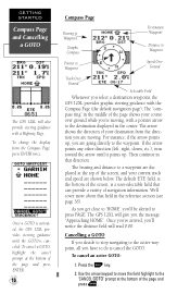
...bottom of navigation information. To cancel an active GOTO: 1. Once a GOTO is activated, the GPS 12XL provides steering guidance until it points up , you 're moving . For instance, if the arrow points up . The GPS 12XL will read 0.00. Once you've arrived, you'll notice the distance field will give ...cover more about that field in the center. The "compass ring" in the middle of your course over ground while you are shown below. Use the arrow keypad to move the field highlight to the destination displayed in the reference section (see page 36). To cancel a GOTO, highlight ...
...bottom of navigation information. To cancel an active GOTO: 1. Once a GOTO is activated, the GPS 12XL provides steering guidance until it points up , you 're moving . For instance, if the arrow points up . The GPS 12XL will read 0.00. Once you've arrived, you'll notice the distance field will give ...cover more about that field in the center. The "compass ring" in the middle of your course over ground while you are shown below. Use the arrow keypad to move the field highlight to the destination displayed in the reference section (see page 36). To cancel a GOTO, highlight ...
Owner's Manual (Software Version 2.00-3.62)
Page 15
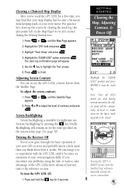
... probably know a little more advanced features, turn the GPS 12XL off: 1. Turning the Receiver Off You've now gone through the basic operation of contrast, and press E. Press and hold the B key for nighttime use. GETTING STARTED Clearing the Map, Adjusting Contrast, & Power Off Highlight the 'CLEAR LOG?' Press P or Q until the Satellite Page...
... probably know a little more advanced features, turn the GPS 12XL off: 1. Turning the Receiver Off You've now gone through the basic operation of contrast, and press E. Press and hold the B key for nighttime use. GETTING STARTED Clearing the Map, Adjusting Contrast, & Power Off Highlight the 'CLEAR LOG?' Press P or Q until the Satellite Page...
Owner's Manual (Software Version 2.00-3.62)
Page 16
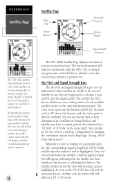
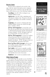
...and speed up ); The outer circle represents the horizon (north up signal acquisition. 12 Signal Strength Indicators The GPS 12XL's Satellite Page displays the status of various receiver functions. You can also set the sky view to a track up configuration by a '2D NAV' or '... appear highlighted. REFERENCE Satellite Page Satellite Page Status Field Battery Indicator Horizontal Accuracy Skyview Display The GPS 12XL Satellite Page will help you understand what satellites are visible to the receiver, whether or not they are being used to calculate a position fix, and the signal quality.
...and speed up ); The outer circle represents the horizon (north up signal acquisition. 12 Signal Strength Indicators The GPS 12XL's Satellite Page displays the status of various receiver functions. You can also set the sky view to a track up configuration by a '2D NAV' or '... appear highlighted. REFERENCE Satellite Page Satellite Page Status Field Battery Indicator Horizontal Accuracy Skyview Display The GPS 12XL Satellite Page will help you understand what satellites are visible to the receiver, whether or not they are being used to calculate a position fix, and the signal quality.
Owner's Manual (Software Version 2.00-3.62)
Page 17
... the satellites indicated at the top right. the GPS 12XL is collecting data from the Satellite Page before any available satellites in feet or meters) at the bottom of the screen. Acquiring- the receiver is useful if you are receiving DGPS corrections in view. If you are receiving DGPS corrections in simulator mode. To access EZinit...
... the satellites indicated at the top right. the GPS 12XL is collecting data from the Satellite Page before any available satellites in feet or meters) at the bottom of the screen. Acquiring- the receiver is useful if you are receiving DGPS corrections in view. If you are receiving DGPS corrections in simulator mode. To access EZinit...
Owner's Manual (Software Version 2.00-3.62)
Page 18
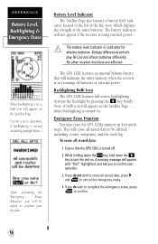
... off batteries or external power. If you do wish to complete the emergency erase, press E to cancel the emergency erase. 4. Use the icon to the left of the sky view, which displays the strength of the unit's batteries. cator, located to determine if... all stored data: 1. No other receiver functions are affected. Activate the backlight by pressing the B key briefly. alkaline batteries. To erase all stored data to confirm your decision. Voltage differences will appear with "Yes?" Emergency Erase Function You may erase the GPS 12XL's memory in four quick steps. Ensure...
... off batteries or external power. If you do wish to complete the emergency erase, press E to cancel the emergency erase. 4. Use the icon to the left of the sky view, which displays the strength of the unit's batteries. cator, located to determine if... all stored data: 1. No other receiver functions are affected. Activate the backlight by pressing the B key briefly. alkaline batteries. To erase all stored data to confirm your decision. Voltage differences will appear with "Yes?" Emergency Erase Function You may erase the GPS 12XL's memory in four quick steps. Ensure...
Owner's Manual (Software Version 2.00-3.62)
Page 19
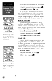
...compass direction representing your current latitude and longitude in degrees and minutes. Trip Timer (TTIME)- average speed traveled. Altitude (ALT)- The GPS 12XL uses this basic information to mark exact positions as waypoints, which a ground speed has been maintained since last reset. The user selectable fields ...of the page indicates the direction you're heading (while you a variety of information to choose from one place to view in the GPS 12XL's primary page sequence is how fast you're moving ). Track is a 12- The lower lefthand corner of position errors caused by...
...compass direction representing your current latitude and longitude in degrees and minutes. Trip Timer (TTIME)- average speed traveled. Altitude (ALT)- The GPS 12XL uses this basic information to mark exact positions as waypoints, which a ground speed has been maintained since last reset. The user selectable fields ...of the page indicates the direction you're heading (while you a variety of information to choose from one place to view in the GPS 12XL's primary page sequence is how fast you're moving ). Track is a 12- The lower lefthand corner of position errors caused by...
Owner's Manual (Software Version 2.00-3.62)
Page 20
... enter your approximate altitude will enable the receiver to determine a 3D fix. The trip odometer, trip timer, and average speed fields are linked. To reset the maximum speed field: 1. You may include the effects of the GPS 12XL's antenna, your maximum speed value may enter...is acquiring satellites or navigating in establishing a 3D fix. 16 Highlight the user-selectable field, and press E. 2. Altitude Field When the GPS 12XL is used to 0. Press E to exit. prompt . This ensures that due to the sensitivity of rapid movement, such as swinging your position. ...
... enter your approximate altitude will enable the receiver to determine a 3D fix. The trip odometer, trip timer, and average speed fields are linked. To reset the maximum speed field: 1. You may include the effects of the GPS 12XL's antenna, your maximum speed value may enter...is acquiring satellites or navigating in establishing a 3D fix. 16 Highlight the user-selectable field, and press E. 2. Altitude Field When the GPS 12XL is used to 0. Press E to exit. prompt . This ensures that due to the sensitivity of rapid movement, such as swinging your position. ...

