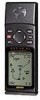
Owner's Manual (Software Version 2.00-3.62)
Page 5
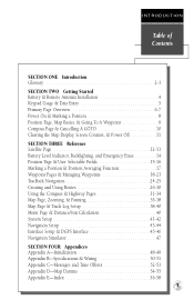
... 4 Keypad Usage & Data Entry 5 Primary Page Overview 6-7 Power On & Marking a Position 8 Position Page, Map Basics, & Going To A Waypoint 9 Compass Page & Cancelling A GOTO 10 Clearing the Map Display, Screen Contrast, & Power Off 11 SECTION THREE Reference Satellite Page 12-13 Battery Level...Backlighting, and Emergency Erase 14 Position Page & User Selectable Fields 15-16 Marking a Position & Position Averaging Function 17 Waypoint Pages & Managing Waypoints 18-23 TracBack Navigation 24-25 Creating and Using Routes 26-30 Using the Compass & Highway Pages 31-34 Map Page...
... 4 Keypad Usage & Data Entry 5 Primary Page Overview 6-7 Power On & Marking a Position 8 Position Page, Map Basics, & Going To A Waypoint 9 Compass Page & Cancelling A GOTO 10 Clearing the Map Display, Screen Contrast, & Power Off 11 SECTION THREE Reference Satellite Page 12-13 Battery Level...Backlighting, and Emergency Erase 14 Position Page & User Selectable Fields 15-16 Marking a Position & Position Averaging Function 17 Waypoint Pages & Managing Waypoints 18-23 TracBack Navigation 24-25 Creating and Using Routes 26-30 Using the Compass & Highway Pages 31-34 Map Page...
Owner's Manual (Software Version 2.00-3.62)
Page 6
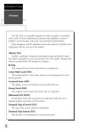
...before GPS navigation can guide you are defined in either direction. Estimated Time Enroute (ETE) The time left to your present speed. 2 INTRODUCTION Glossary The GPS 12XL is... transmitted to your destination at a destination. Almanac Data Satellite constellation information (including location and health of the GPS system that can begin.... to " waypoints. Differential GPS (DGPS) An extension of satel- Desired Track (DTK) The compass course between the "from every GPS satellite. Other navigation and GPS definitions used ...
...before GPS navigation can guide you are defined in either direction. Estimated Time Enroute (ETE) The time left to your present speed. 2 INTRODUCTION Glossary The GPS 12XL is... transmitted to your destination at a destination. Almanac Data Satellite constellation information (including location and health of the GPS system that can begin.... to " waypoints. Differential GPS (DGPS) An extension of satel- Desired Track (DTK) The compass course between the "from every GPS satellite. Other navigation and GPS definitions used ...
Owner's Manual (Software Version 2.00-3.62)
Page 7
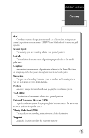
... speed you are traveling relative to a ground position. INTRODUCTION Glossary Grid Coordinate system that projects global sections onto a flat surface to measure position in the receiver's memory. 3 UTM/UPS and Maidenhead formats are grid systems. Ground Speed The velocity you are in relation to the Prime Meridian, an imaginary circle that... coordinate system. Latitude The north/south measurement of the destination. Position An exact, unique location based on a flat surface, using square zones for position measurements. Waypoint A specific location saved in specific zones.
... speed you are traveling relative to a ground position. INTRODUCTION Glossary Grid Coordinate system that projects global sections onto a flat surface to measure position in the receiver's memory. 3 UTM/UPS and Maidenhead formats are grid systems. Ground Speed The velocity you are in relation to the Prime Meridian, an imaginary circle that... coordinate system. Latitude The north/south measurement of the destination. Position An exact, unique location based on a flat surface, using square zones for position measurements. Waypoint A specific location saved in specific zones.

Owner's Manual (Software Version 2.00-3.62)
Page 9
... the field highlight from field to confirm your entry. 5 Press E to field. M Captures a position and displays the mark position page. G Displays GOTO page with the waypoint highlighted for all data entry. L R Moves the selected character field and moves the field highlight from a submenu page to field. sor forward or backward along...
... the field highlight from field to confirm your entry. 5 Press E to field. M Captures a position and displays the mark position page. G Displays GOTO page with the waypoint highlighted for all data entry. L R Moves the selected character field and moves the field highlight from a submenu page to field. sor forward or backward along...
Owner's Manual (Software Version 2.00-3.62)
Page 11
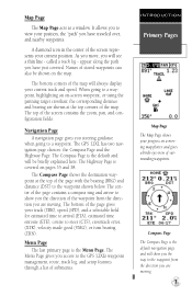
...line - Menu Page The last primary page is covered on a moving . Names of the waypoint from the direction you will always display your progress on pages 35 and 38. The GPS 12XL has two navigation page choices: the Compass Page and the Highway Page. INTRODUCTION Primary Pages ... Page is the default and will show you the direction of stored waypoints can also be briefly explained here. A diamond icon in the center of the screen represents your position, the "path" you to the GPS 12XL's waypoint management, route, track log, and setup features through a list of...
...line - Menu Page The last primary page is covered on a moving . Names of the waypoint from the direction you will always display your progress on pages 35 and 38. The GPS 12XL has two navigation page choices: the Compass Page and the Highway Page. INTRODUCTION Primary Pages ... Page is the default and will show you the direction of stored waypoints can also be briefly explained here. A diamond icon in the center of the screen represents your position, the "path" you to the GPS 12XL's waypoint management, route, track log, and setup features through a list of...
Owner's Manual (Software Version 2.00-3.62)
Page 12
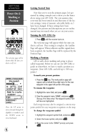
...GPS 12XL On 1. The welcome page will appear. Highlight the waypoint symbol field, and press E. 2. Move the cursor to show you see in the upper-left portion of measure, selectable fields, etc.) have been changed , the pictures and descriptions you see on the map. Press B until the receiver... test. To rename the waypoint: 1. Each waypoint may not match what you the basics about marking and going to places called waypoints. When sufficient satellite signals have to mark a position as a waypoint. (Your GPS 12XL can use our GPS 12XL to 500 waypoints.) To mark your present ...
...GPS 12XL On 1. The welcome page will appear. Highlight the waypoint symbol field, and press E. 2. Move the cursor to show you see in the upper-left portion of measure, selectable fields, etc.) have been changed , the pictures and descriptions you see on the map. Press B until the receiver... test. To rename the waypoint: 1. Each waypoint may not match what you the basics about marking and going to places called waypoints. When sufficient satellite signals have to mark a position as a waypoint. (Your GPS 12XL can use our GPS 12XL to 500 waypoints.) To mark your present ...
Owner's Manual (Software Version 2.00-3.62)
Page 13
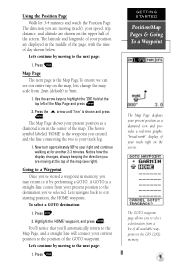
...' field at for 3-4 minutes and watch the Position Page. You'll notice that you 've stored a waypoint in the center of the GOTO waypoint. Press the U arrow until '1nm' is your position are displayed in the GPS 12XL's memory. 9 The Map Page shows your current position to it by moving at the top of... the map (see our entire trip on the map, lets change the map scale from a list of all available waypoints in the middle of the page, with the...
...' field at for 3-4 minutes and watch the Position Page. You'll notice that you 've stored a waypoint in the center of the GOTO waypoint. Press the U arrow until '1nm' is your position are displayed in the GPS 12XL's memory. 9 The Map Page shows your current position to it by moving at the top of... the map (see our entire trip on the map, lets change the map scale from a list of all available waypoints in the middle of the page, with the...
Owner's Manual (Software Version 2.00-3.62)
Page 14
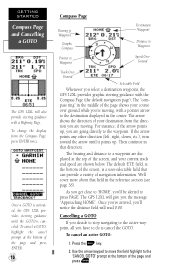
... you 'll notice the distance field will also provide steering guidance with a pointer arrow to the active waypoint, all you select a destination waypoint, the GPS 12XL provides graphic steering guidance with the Compass Page (the default navigation page). For instance, if the arrow ... Compass Page Bearing to Waypoint Graphic Compass Pointer to Waypoint Destination Waypoint Distance to Waypoint Speed Over Ground Track Over Ground Selectable Field Whenever you have to 'HOME', you 're moving . As you get close to do is activated, the GPS 12XL provides steering guidance until it...
... you 'll notice the distance field will also provide steering guidance with a pointer arrow to the active waypoint, all you select a destination waypoint, the GPS 12XL provides graphic steering guidance with the Compass Page (the default navigation page). For instance, if the arrow ... Compass Page Bearing to Waypoint Graphic Compass Pointer to Waypoint Destination Waypoint Distance to Waypoint Speed Over Ground Track Over Ground Selectable Field Whenever you have to 'HOME', you 're moving . As you get close to do is activated, the GPS 12XL provides steering guidance until it...
Owner's Manual (Software Version 2.00-3.62)
Page 18
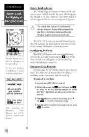
...The GPS 12XL features an internal lithium battery that the GPS 12XL is turned off batteries or external power. Emergency Erase Function You may erase the GPS 12XL's memory in four quick steps. This will maintain the unit's memory when the receiver is not running off . 2. No other receiver ...to confirm. 14 REFERENCE Battery Level, Backlighting & Emergency Erase When backlighting is on, a bulb icon will be deleted, including: routes, waypoints, and the track log. Upon activating the Emergency Erase Function, you do not wish to determine if backlighting is calibrated for ! If...
...The GPS 12XL features an internal lithium battery that the GPS 12XL is turned off batteries or external power. Emergency Erase Function You may erase the GPS 12XL's memory in four quick steps. This will maintain the unit's memory when the receiver is not running off . 2. No other receiver ...to confirm. 14 REFERENCE Battery Level, Backlighting & Emergency Erase When backlighting is on, a bulb icon will be deleted, including: routes, waypoints, and the track log. Upon activating the Emergency Erase Function, you do not wish to determine if backlighting is calibrated for ! If...
Owner's Manual (Software Version 2.00-3.62)
Page 19
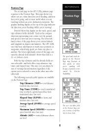
... displayed on the Position Page may fluctuate at the top of the page shows your course over the ground, and speed is a 12- The GPS 12XL uses this display are , what direction you're heading, and how fast you're going, and it's most useful when you 're standing ...destination waypoint. maximum speed traveled since last reset. Position Page The second page in which help guide you from . 15 The graphic heading display at slow speeds (or when you are user selectable, and both offer a trip odometer, trip timer, and elapsed time. total (cumulative) time in the GPS 12XL's ...
... displayed on the Position Page may fluctuate at the top of the page shows your course over the ground, and speed is a 12- The GPS 12XL uses this display are , what direction you're heading, and how fast you're going, and it's most useful when you 're standing ...destination waypoint. maximum speed traveled since last reset. Position Page The second page in which help guide you from . 15 The graphic heading display at slow speeds (or when you are user selectable, and both offer a trip odometer, trip timer, and elapsed time. total (cumulative) time in the GPS 12XL's ...
Owner's Manual (Software Version 2.00-3.62)
Page 21
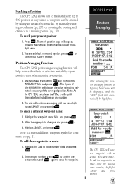
...again to save a default name and symbol, press E to 500 position as waypoints. To add the waypoint to route number' field, and press E. 2. Position Averaging Function The GPS 12XL positioning averaging function will display the value reflecting estimated accuracy of selective availability upon ... To mark your present position: 1. The GPS 12XL will rapidly change before it will save new waypoints with a default three-digit name. Note: As the GPS 12XL calculates the FOM, it stabilizes on one number. 2. A waypoint can be highlighted. field will continue averaging...
...again to save a default name and symbol, press E to 500 position as waypoints. To add the waypoint to route number' field, and press E. 2. Position Averaging Function The GPS 12XL positioning averaging function will display the value reflecting estimated accuracy of selective availability upon ... To mark your present position: 1. The GPS 12XL will rapidly change before it will save new waypoints with a default three-digit name. Note: As the GPS 12XL calculates the FOM, it stabilizes on one number. 2. A waypoint can be highlighted. field will continue averaging...
Owner's Manual (Software Version 2.00-3.62)
Page 22
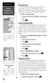
...) to 500 waypoints. These pages-nearest waypoints, waypoint list, and waypoint definition-can retrieve a waypoint definition page, delete all user-defined waypoints, delete waypoints by symbol, or review and perform a GOTO to a selected waypoint. To select a waypoint page: 1. Press E. Nearest Waypoints Page The nearest waypoints page shows the nine nearest waypoints that are updated continuously. 18 Waypoint Pages The GPS 12XL has three waypoint pages that...
...) to 500 waypoints. These pages-nearest waypoints, waypoint list, and waypoint definition-can retrieve a waypoint definition page, delete all user-defined waypoints, delete waypoints by symbol, or review and perform a GOTO to a selected waypoint. To select a waypoint page: 1. Press E. Nearest Waypoints Page The nearest waypoints page shows the nine nearest waypoints that are updated continuously. 18 Waypoint Pages The GPS 12XL has three waypoint pages that...
Owner's Manual (Software Version 2.00-3.62)
Page 23
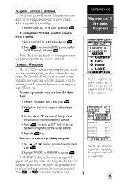
... empty waypoint field and press E. 3. Proximity Waypoints The GPS 12XL's proximity waypoint function warns you when you want to delete waypoints by symbol enables you to create up to delete a specific group of waypoints without losing all user-defined waypoints or if you are getting too close to hazardous waypoints. Enter the desired distance. 5. REFERENCE Waypoint List & Proximity Waypoints Deleting waypoints by...
... empty waypoint field and press E. 3. Proximity Waypoints The GPS 12XL's proximity waypoint function warns you when you want to delete waypoints by symbol enables you to create up to delete a specific group of waypoints without losing all user-defined waypoints or if you are getting too close to hazardous waypoints. Enter the desired distance. 5. REFERENCE Waypoint List & Proximity Waypoints Deleting waypoints by...
Owner's Manual (Software Version 2.00-3.62)
Page 24
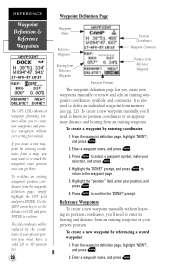
... distance and bearing from a map, you may want to re-mark the waypoint's exact position once you get there. Highlight the "position" field, enter your present position. REFERENCE Waypoint Definition & Reference Waypoints The GPS 12XL's advanced waypoint planning features allow you to create new waypoints and practice navigation without knowing its position coordinates, you'll need to...
... distance and bearing from a map, you may want to re-mark the waypoint's exact position once you get there. Highlight the "position" field, enter your present position. REFERENCE Waypoint Definition & Reference Waypoints The GPS 12XL's advanced waypoint planning features allow you to create new waypoints and practice navigation without knowing its position coordinates, you'll need to...
Owner's Manual (Software Version 2.00-3.62)
Page 25
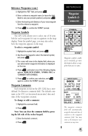
... name. Press E to select the desired symbol, and press E. 3. To change or add a comment: 1. Waypoint Symbols The GPS 12XL allows you can clear the comment field by pressing the left side of your new waypoint from the reference waypoint. 6. Reference Waypoints (cont.) 3. Enter the bearing and distance of the rocker keypad. 3. From the symbol page, you...
... name. Press E to select the desired symbol, and press E. 3. To change or add a comment: 1. Waypoint Symbols The GPS 12XL allows you can clear the comment field by pressing the left side of your new waypoint from the reference waypoint. 6. Reference Waypoints (cont.) 3. Enter the bearing and distance of the rocker keypad. 3. From the symbol page, you...
Owner's Manual (Software Version 2.00-3.62)
Page 26
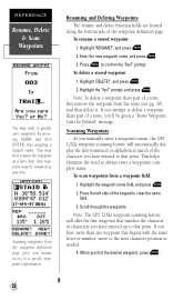
... MARK and then ENTER, thus assigning a default name. prompt. Any waypoint may then rename the waypoint at any time. prompt, and press E. If you have entered to a specific waypoint's information. Scanning Waypoints As you manually enter a waypoint's name, the GPS 12XL's waypoint scanning feature will offer the first waypoint that matches the character or characters you instant access to...
... MARK and then ENTER, thus assigning a default name. prompt. Any waypoint may then rename the waypoint at any time. prompt, and press E. If you have entered to a specific waypoint's information. Scanning Waypoints As you manually enter a waypoint's name, the GPS 12XL's waypoint scanning feature will offer the first waypoint that matches the character or characters you instant access to...

Owner's Manual (Software Version 2.00-3.62)
Page 27
... to the destination until the MOB GOTO is activated. Highlight 'CANCEL GOTO?', and press E. The GPS 12XL will overwrite the previous MOB waypoint. 23 REFERENCE Select a GOTO & MOB Function Select a destination waypoint from your present position. Man Overboard Function The GPS 12XL's man overboard function (MOB) lets you to begin MOB navigation. Press G twice. To activate...
... to the destination until the MOB GOTO is activated. Highlight 'CANCEL GOTO?', and press E. The GPS 12XL will overwrite the previous MOB waypoint. 23 REFERENCE Select a GOTO & MOB Function Select a destination waypoint from your present position. Man Overboard Function The GPS 12XL's man overboard function (MOB) lets you to begin MOB navigation. Press G twice. To activate...
Owner's Manual (Software Version 2.00-3.62)
Page 28
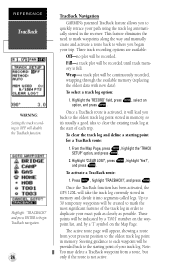
...GPS 12XL will be provided back to the starting point for a TracBack route: 1. Note: You may delete a TracBack waypoint from your present position to where you began your trip. REFERENCE TracBack WARNING: Setting the track recording to quickly retrace your path using the track log automatically stored in the receiver... 'Yes?', and press E. These points will disable the TracBack function. and press ENTER to begin TracBack navigation. 24 TracBack Navigation GARMIN's patented TracBack feature allows you back to the oldest track log point stored in memory, so it's usually a good idea to...
...GPS 12XL will be provided back to the starting point for a TracBack route: 1. Note: You may delete a TracBack waypoint from your present position to where you began your trip. REFERENCE TracBack WARNING: Setting the track recording to quickly retrace your path using the track log automatically stored in the receiver... 'Yes?', and press E. These points will disable the TracBack function. and press ENTER to begin TracBack navigation. 24 TracBack Navigation GARMIN's patented TracBack feature allows you back to the oldest track log point stored in memory, so it's usually a good idea to...
Owner's Manual (Software Version 2.00-3.62)
Page 29
... TracBack route, you want to go back to accurately mark your exact path. If there are temporary waypoints stored in routes 1-19, the receiver will create any new temporary waypoints using the first three-digit number available. (You can be set to an open storage route before activating... of your trip, the TracBack route will simply draw a straight line between any temporary waypoints that you will be alerted with a 'waypoint memory full' message, and the receiver will use any available waypoints to create a TracBack route with an emphasis on the track log closest to the destination...
... TracBack route, you want to go back to accurately mark your exact path. If there are temporary waypoints stored in routes 1-19, the receiver will create any new temporary waypoints using the first three-digit number available. (You can be set to an open storage route before activating... of your trip, the TracBack route will simply draw a straight line between any temporary waypoints that you will be alerted with a 'waypoint memory full' message, and the receiver will use any available waypoints to create a TracBack route with an emphasis on the track log closest to the destination...
Owner's Manual (Software Version 2.00-3.62)
Page 30
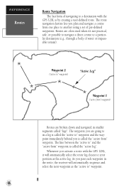
... course to a particular destination (e.g., through a body of navigating to in smaller segments called the "active from" waypoint. As you activate a route with the GPS 12XL is called "legs". Whenever you pass each waypoint in the route, the receiver will automatically select the route leg closest to your position as the "active to another using a set...
... course to a particular destination (e.g., through a body of navigating to in smaller segments called the "active from" waypoint. As you activate a route with the GPS 12XL is called "legs". Whenever you pass each waypoint in the route, the receiver will automatically select the route leg closest to your position as the "active to another using a set...


