GPS 12, 12XL, 48, 80 Addendum
Page 1
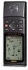
...'s Manual for directions on clearing the track log. Addendum GPS12,12XL, 48, 80 Calculate Track Area Power Save Mode 1 Please refer to display the SETUP MENU. 2. From the Map Page, highlight the 'OPT' selection at the top of the Power Save feature should not negatively affect operation under normal circumstances...will measure the area enclosed between the first and last points in the CALC AREA menu and press ENTER. 2. Power Save optimizes the GPS receiver to have a non-linear track. You may notice some delay in the System Setup Menu. The unit used to measure the area can now...
...'s Manual for directions on clearing the track log. Addendum GPS12,12XL, 48, 80 Calculate Track Area Power Save Mode 1 Please refer to display the SETUP MENU. 2. From the Map Page, highlight the 'OPT' selection at the top of the Power Save feature should not negatively affect operation under normal circumstances...will measure the area enclosed between the first and last points in the CALC AREA menu and press ENTER. 2. Power Save optimizes the GPS receiver to have a non-linear track. You may notice some delay in the System Setup Menu. The unit used to measure the area can now...
Owner's Manual (Software Version 2.00-3.62)
Page 3
... you to the basic features of the unit and provides a quick-start orientation to the GPS 12XL. Before getting started with multiple listings, such as map datums, time offsets, and the index. Reference provides details about the advanced features and operations...8226; 4 AA Batteries See your GARMIN dealer for years. The GPS 12XL represents GARMIN's continuing commitment to understand the operating features of the GPS 12XL. The Appendix section contains initialization instructions and items with your GPS, check to see that your GARMIN GPS 12XL package includes the following items. If...
... you to the basic features of the unit and provides a quick-start orientation to the GPS 12XL. Before getting started with multiple listings, such as map datums, time offsets, and the index. Reference provides details about the advanced features and operations...8226; 4 AA Batteries See your GARMIN dealer for years. The GPS 12XL represents GARMIN's continuing commitment to understand the operating features of the GPS 12XL. The Appendix section contains initialization instructions and items with your GPS, check to see that your GARMIN GPS 12XL package includes the following items. If...

Owner's Manual (Software Version 2.00-3.62)
Page 4
...become unsafe. Although the GPS 12XL is encouraged to try and correct the interference by relocating the equipment or connecting the equipment to a different circuit than the affected equipment. If this device must accept any interference received, including interference that interference...sightings, maps, etc. Operation is no guarantee that may cause harmful interference to radio communications. Unauthorized repairs or modifications could affect the accuracy and performance of all available navigation sources including the information from the GPS 12XL to all GPS equipment. ...
...become unsafe. Although the GPS 12XL is encouraged to try and correct the interference by relocating the equipment or connecting the equipment to a different circuit than the affected equipment. If this device must accept any interference received, including interference that interference...sightings, maps, etc. Operation is no guarantee that may cause harmful interference to radio communications. Unauthorized repairs or modifications could affect the accuracy and performance of all available navigation sources including the information from the GPS 12XL to all GPS equipment. ...
Owner's Manual (Software Version 2.00-3.62)
Page 5
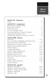
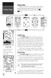
...Installation 4 Keypad Usage & Data Entry 5 Primary Page Overview 6-7 Power On & Marking a Position 8 Position Page, Map Basics, & Going To A Waypoint 9 Compass Page & Cancelling A GOTO 10 Clearing the Map Display, Screen Contrast, & Power Off 11 SECTION THREE Reference Satellite Page 12-13 Battery Level Indicator, Backlighting, and... 18-23 TracBack Navigation 24-25 Creating and Using Routes 26-30 Using the Compass & Highway Pages 31-34 Map Page, Zooming, & Panning 35-38 Map Page & Track Log Setup 38-40 Menu Page & Distance/Sun Calculation 40 System Setup 41-42 Navigation Setup ...
...Installation 4 Keypad Usage & Data Entry 5 Primary Page Overview 6-7 Power On & Marking a Position 8 Position Page, Map Basics, & Going To A Waypoint 9 Compass Page & Cancelling A GOTO 10 Clearing the Map Display, Screen Contrast, & Power Off 11 SECTION THREE Reference Satellite Page 12-13 Battery Level Indicator, Backlighting, and... 18-23 TracBack Navigation 24-25 Creating and Using Routes 26-30 Using the Compass & Highway Pages 31-34 Map Page, Zooming, & Panning 35-38 Map Page & Track Log Setup 38-40 Menu Page & Distance/Sun Calculation 40 System Setup 41-42 Navigation Setup ...
Owner's Manual (Software Version 2.00-3.62)
Page 10
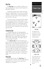
J Satellite Position Map Compass Menu Q Satellite Page The Satellite Page will show you to each satellite being used for the GPS 12XL. The outer circle shows satellites on level with the horizon; The top of the page contains a compass tape which is 45º above the horizon; A ...
J Satellite Position Map Compass Menu Q Satellite Page The Satellite Page will show you to each satellite being used for the GPS 12XL. The outer circle shows satellites on level with the horizon; The top of the page contains a compass tape which is 45º above the horizon; A ...
Owner's Manual (Software Version 2.00-3.62)
Page 11
... crosshair, the corresponding distance and bearing are shown at the top of the waypoint from the direction you are moving . When going to the GPS 12XL's waypoint management, route, track log, and setup features through a list of the screen represents your current track and speed. The top of... course to show you have traveled over, and nearby waypoints. A diamond icon in the center of submenus. The bottom corners of the map. The GPS 12XL has two navigation page choices: the Compass Page and the Highway Page. The Compass Page shows the destination waypoint at the top corners of...
... crosshair, the corresponding distance and bearing are shown at the top of the waypoint from the direction you are moving . When going to the GPS 12XL's waypoint management, route, track log, and setup features through a list of the screen represents your current track and speed. The top of... course to show you have traveled over, and nearby waypoints. A diamond icon in the center of submenus. The bottom corners of the map. The GPS 12XL has two navigation page choices: the Compass Page and the Highway Page. The Compass Page shows the destination waypoint at the top corners of...
Owner's Manual (Software Version 2.00-3.62)
Page 12
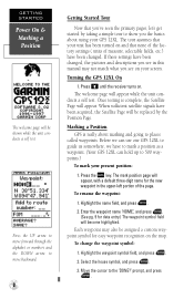
...page will become highlighted. To rename the waypoint: 1. Highlight the waypoint symbol field, and press E. 2. Press B until the receiver turns on and that you see on the map. Once testing is really about using your screen. Select the house symbol, and press E. 3. The welcome page will appear. prompt...while the unit conducts a self test. Enter the waypoint name 'HOME', and press E. (See pg. 9 for easy waypoint recognition on your GPS 12XL. Before we can hold up to places called waypoints. Press the M key. Each waypoint may not match what you see in the upper-...
...page will become highlighted. To rename the waypoint: 1. Highlight the waypoint symbol field, and press E. 2. Press B until the receiver turns on and that you see on the map. Once testing is really about using your screen. Select the house symbol, and press E. 3. The welcome page will appear. prompt...while the unit conducts a self test. Enter the waypoint name 'HOME', and press E. (See pg. 9 for easy waypoint recognition on your GPS 12XL. Before we can hold up to places called waypoints. Press the M key. Each waypoint may not match what you see in the upper-...
Owner's Manual (Software Version 2.00-3.62)
Page 13
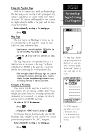
...provides a real-time graphic "breadcrumb" display of your present position as a diamond icon in the middle of the page, with the time of the map. The GOTO waypoint page allows you to select a destination from .2nm (default) to highlight the 'ZM' field at for 3-4 minutes and watch ... A GOTO is a straight-line course from your present position to the Map Page, and a straight line will connect your track log. 1. The direction you may return to it by moving to a Waypoint Once you've stored a waypoint in the GPS 12XL's memory. 9 Going to the next page: 1. Press the U arrow ...
...provides a real-time graphic "breadcrumb" display of your present position as a diamond icon in the middle of the page, with the time of the map. The GOTO waypoint page allows you to select a destination from .2nm (default) to highlight the 'ZM' field at for 3-4 minutes and watch ... A GOTO is a straight-line course from your present position to the Map Page, and a straight line will connect your track log. 1. The direction you may return to it by moving to a Waypoint Once you've stored a waypoint in the GPS 12XL's memory. 9 Going to the next page: 1. Press the U arrow ...
Owner's Manual (Software Version 2.00-3.62)
Page 15
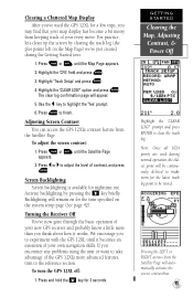
... the screen contrast bar. 11 Adjusting Screen Contrast You can access the GPS 12XL's contrast feature from keeping track of your new GPS receiver and probably know a little more advanced features, turn the GPS 12XL off: 1. To adjust the screen contrast: 1. GETTING STARTED Clearing the Map, Adjusting Contrast, & Power Off Highlight the 'CLEAR LOG?' option and press...
... the screen contrast bar. 11 Adjusting Screen Contrast You can access the GPS 12XL's contrast feature from keeping track of your new GPS receiver and probably know a little more advanced features, turn the GPS 12XL off: 1. To adjust the screen contrast: 1. GETTING STARTED Clearing the Map, Adjusting Contrast, & Power Off Highlight the 'CLEAR LOG?' option and press...
Owner's Manual (Software Version 2.00-3.62)
Page 16
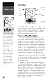
...GPS 12XL Satellite Page will help you determine which satellites are in view, and whether or not any satellites are being blocked, and whether you have a current position fix (indicated by changing the 'orientation' option on the Map Page. (See pg. 38 for setup instructions.) When the receiver... will improve satellite reception and speed up signal acquisition. 12 Signal Strength Indicators The GPS 12XL's Satellite Page displays the status of what the GPS 12XL is collecting data from receiving satellite signals (See satellites 07 and 09 above the horizon; The status information will...
...GPS 12XL Satellite Page will help you determine which satellites are in view, and whether or not any satellites are being blocked, and whether you have a current position fix (indicated by changing the 'orientation' option on the Map Page. (See pg. 38 for setup instructions.) When the receiver... will improve satellite reception and speed up signal acquisition. 12 Signal Strength Indicators The GPS 12XL's Satellite Page displays the status of what the GPS 12XL is collecting data from receiving satellite signals (See satellites 07 and 09 above the horizon; The status information will...
Owner's Manual (Software Version 2.00-3.62)
Page 24
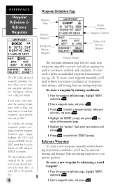
... re-mark the waypoint's exact position once you get there. REFERENCE Waypoint Definition & Reference Waypoints The GPS 12XL's advanced waypoint planning features allow you to the waypoint page. 5. Press E to enter its approximate distance and bearing from a map, you create a new waypoint by referencing a stored waypoint: 1. prompt. Reference Waypoints To create a new waypoint...
... re-mark the waypoint's exact position once you get there. REFERENCE Waypoint Definition & Reference Waypoints The GPS 12XL's advanced waypoint planning features allow you to the waypoint page. 5. Press E to enter its approximate distance and bearing from a map, you create a new waypoint by referencing a stored waypoint: 1. prompt. Reference Waypoints To create a new waypoint...
Owner's Manual (Software Version 2.00-3.62)
Page 25
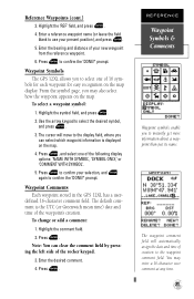
...for easy recognition on the map. 4. The default comment is displayed on the map display. Press E. Reference Waypoints (cont.) 3. Enter a reference waypoint name (or leave the field blank to select the desired symbol, and press E. 3. prompt. Waypoint Symbols The GPS 12XL allows you can clear the...Symbols & Comments Waypoint symbols enable you may enter a 16-character user comment at any time. 21 Waypoint Comments Each waypoint stored in the GPS 12XL has a user- To change or add a comment: 1. Note: You can select which waypoint information is the UTC (or Greenwich mean ...
...for easy recognition on the map. 4. The default comment is displayed on the map display. Press E. Reference Waypoints (cont.) 3. Enter a reference waypoint name (or leave the field blank to select the desired symbol, and press E. 3. prompt. Waypoint Symbols The GPS 12XL allows you can clear the...Symbols & Comments Waypoint symbols enable you may enter a 16-character user comment at any time. 21 Waypoint Comments Each waypoint stored in the GPS 12XL has a user- To change or add a comment: 1. Note: You can select which waypoint information is the UTC (or Greenwich mean ...
Owner's Manual (Software Version 2.00-3.62)
Page 28
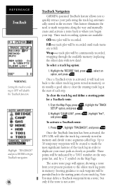
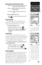
... highlight 'Yes?', and press E. Press G, highlight 'TRACBACK?', and press E. To select a track log option: 1. From the Map Page, press E, highlight the 'TRACK SETUP' option, and press E. 2. Note: You may delete a TracBack waypoint from your... E. Once the TracBack function has been activated, the GPS 12XL will disable the TracBack function. and press ENTER to begin TracBack navigation. 24 TracBack Navigation GARMIN's patented TracBack feature allows you back to the oldest ... log automatically stored in the receiver. Highlight 'TRACBACK?' To activate a TracBack route: 1.
... highlight 'Yes?', and press E. Press G, highlight 'TRACBACK?', and press E. To select a track log option: 1. From the Map Page, press E, highlight the 'TRACK SETUP' option, and press E. 2. Note: You may delete a TracBack waypoint from your... E. Once the TracBack function has been activated, the GPS 12XL will disable the TracBack function. and press ENTER to begin TracBack navigation. 24 TracBack Navigation GARMIN's patented TracBack feature allows you back to the oldest ... log automatically stored in the receiver. Highlight 'TRACBACK?' To activate a TracBack route: 1.
Owner's Manual (Software Version 2.00-3.62)
Page 39
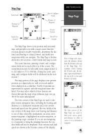
...a destination waypoint and your current track and speed over the ground. Your current track and speed are located at the top corners of the map show your course, speed, and distance to either a cursor or to a waypoint or using the panning function, the top data fields will ... and/or route displayed as squares, with a target cursor that lets you pan ahead to nearby waypoints, determine the distance and bearing to a map position, and mark new waypoints while you navigate. The four corners of three selectable destinations: an active destination waypoint, a highlighted on-screen waypoint,...
...a destination waypoint and your current track and speed over the ground. Your current track and speed are located at the top corners of the map show your course, speed, and distance to either a cursor or to a waypoint or using the panning function, the top data fields will ... and/or route displayed as squares, with a target cursor that lets you pan ahead to nearby waypoints, determine the distance and bearing to a map position, and mark new waypoints while you navigate. The four corners of three selectable destinations: an active destination waypoint, a highlighted on-screen waypoint,...
Owner's Manual (Software Version 2.00-3.62)
Page 40
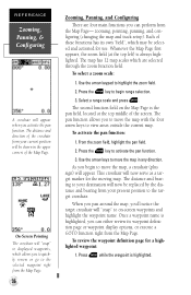
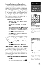
...-Screen Pointing The crosshair will "snap" to displayed waypoints, which allows you to quickly review or go to the selected waypoint right from the Map Page. 36 Zooming, Panning, and Configuring There are selected through the zoom function field. To select a zoom scale: 1. Press the E key... to highlight the zoom field. 2. This crosshair will now serve as a target marker for a highlighted waypoint: 1. When you pan around the map, you can either review its waypoint definition page or waypoint display options, or execute a GOTO function right from your current position will be shown in...
...-Screen Pointing The crosshair will "snap" to displayed waypoints, which allows you to quickly review or go to the selected waypoint right from the Map Page. 36 Zooming, Panning, and Configuring There are selected through the zoom function field. To select a zoom scale: 1. Press the E key... to highlight the zoom field. 2. This crosshair will now serve as a target marker for a highlighted waypoint: 1. When you pan around the map, you can either review its waypoint definition page or waypoint display options, or execute a GOTO function right from your current position will be shown in...
Owner's Manual (Software Version 2.00-3.62)
Page 41
...directly to the waypoint. Enter a name and/or route number, and press E. Marking a Cursor Position To mark a new waypoint with a waypoint highlighted on the Map Page, with a corresponding symbol (e.g., "nearest fuel" and a gas pump symbol), a symbol only (e.g., a fish symbol), or a 16-character comment and corresponding symbol... to the right of the screen. To go to a waypoint highlighted on the waypoint definition page) to return to the Map Page. The GPS 12XL displays waypoints as a name with the range and bearing to the target displayed at the top corners of the name field), ...
...directly to the waypoint. Enter a name and/or route number, and press E. Marking a Cursor Position To mark a new waypoint with a waypoint highlighted on the Map Page, with a corresponding symbol (e.g., "nearest fuel" and a gas pump symbol), a symbol only (e.g., a fish symbol), or a 16-character comment and corresponding symbol... to the right of the screen. To go to a waypoint highlighted on the waypoint definition page) to return to the Map Page. The GPS 12XL displays waypoints as a name with the range and bearing to the target displayed at the top corners of the name field), ...
Owner's Manual (Software Version 2.00-3.62)
Page 42
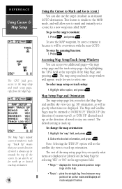
... are displayed. The default setting is track up (or towards the top of) the screen. The rest of the map setup page lets you to (cont.) You can access two additional pages-the map setup page and the track setup page-by selecting 'YES' or 'NO' in the appropriate field. • '... straight-leg lines between waypoints of an active route and displays all route waypoint names. This feature is always up . To select map setup or track setup: 1. To change the map orientation: 1. It can also be overwritten with the next GOTO. To go to track up orientation. 38 Using the Cursor to...
... are displayed. The default setting is track up (or towards the top of) the screen. The rest of the map setup page lets you to (cont.) You can access two additional pages-the map setup page and the track setup page-by selecting 'YES' or 'NO' in the appropriate field. • '... straight-leg lines between waypoints of an active route and displays all route waypoint names. This feature is always up . To select map setup or track setup: 1. To change the map orientation: 1. It can also be overwritten with the next GOTO. To go to track up orientation. 38 Using the Cursor to...
Owner's Manual (Software Version 2.00-3.62)
Page 43
...the track points displayed will increase the distance you manage the GPS 12XL's track log data. This will not affect whether the receiver records a track log or the ability to display on or off: 1. To turn the track log on the Map Page. Track Setup Page The track setup page lets you...points will greatly reduce the effectiveness of points the unit will plot your track log. Entering a time interval in to control the way the GPS 12XL manages your position points further apart than they would be lost as new points are stored in the 'Automatic' setting. shows the nine nearest...
...the track points displayed will increase the distance you manage the GPS 12XL's track log data. This will not affect whether the receiver records a track log or the ability to display on or off: 1. To turn the track log on the Map Page. Track Setup Page The track setup page lets you...points will greatly reduce the effectiveness of points the unit will plot your track log. Entering a time interval in to control the way the GPS 12XL manages your position points further apart than they would be lost as new points are stored in the 'Automatic' setting. shows the nine nearest...
Owner's Manual (Software Version 2.00-3.62)
Page 47
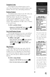
...mm.mmm'). Select 'User Grid', and press E. Although 106 total map datums are available for use (see Appendix D for the GPS 12XL is the default setting. Select the desired setting, and press E. The default map datum covers world-wide navigation. Position Formats The default position format for... map datums), you should only change the datum if you are using maps or charts that datum. ...
...mm.mmm'). Select 'User Grid', and press E. Although 106 total map datums are available for use (see Appendix D for the GPS 12XL is the default setting. Select the desired setting, and press E. The default map datum covers world-wide navigation. Position Formats The default position format for... map datums), you should only change the datum if you are using maps or charts that datum. ...
Owner's Manual (Software Version 2.00-3.62)
Page 48
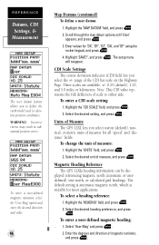
...' option and enter the desired direction and value. 44 Map Datums (continued) To define a user datum: 1. Enter values for all "speed" and "distance" fields. Note: This CDI value represents the full deflection of Measure The GPS 12XL lets you select the +/- Units of scale to calculate ...position coordinates. Magnetic Heading Reference The GPS 12XL's heading information can be dis- Enter the degrees and direction of the CDI bar ...
...' option and enter the desired direction and value. 44 Map Datums (continued) To define a user datum: 1. Enter values for all "speed" and "distance" fields. Note: This CDI value represents the full deflection of Measure The GPS 12XL lets you select the +/- Units of scale to calculate ...position coordinates. Magnetic Heading Reference The GPS 12XL's heading information can be dis- Enter the degrees and direction of the CDI bar ...


