GPS 12, 12XL, 48, 80 Addendum
Page 1
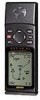
...when making a sudden turn, but use the CALC AREA feature, do not let the track log cross over itself. Power Save optimizes the GPS receiver to your GPS Owner's Manual for directions on clearing the track log. To activate the Power Save feature: 1. Highlight the 'MODE' field and ...press ENTER. 4. Please refer to conserve battery power. This will cause the unit to clear the track log. Highlight 'TRACK SETUP' and press ENTER. 3. Addendum GPS12,12XL...
...when making a sudden turn, but use the CALC AREA feature, do not let the track log cross over itself. Power Save optimizes the GPS receiver to your GPS Owner's Manual for directions on clearing the track log. To activate the Power Save feature: 1. Highlight the 'MODE' field and ...press ENTER. 4. Please refer to conserve battery power. This will cause the unit to clear the track log. Highlight 'TRACK SETUP' and press ENTER. 3. Addendum GPS12,12XL...
Owner's Manual (Software Version 2.00-3.62)
Page 3
...design you meet all of your navigation needs and know it will help you 'll enjoy for outdoor use! We at GARMIN hope the GPS 12XL will become a valuable piece of your convenience: Introduction gives a quick overview of the manual and contains the table of contents...of navigational terms. Getting Started introduces you for choosing the GARMIN GPS 12XL -the smallest, easiest-to-use GPS navigator for years. The Appendix section contains initialization instructions and items with your GPS, check to see that your GARMIN GPS 12XL package includes the following items. If you are missing any...
...design you meet all of your navigation needs and know it will help you 'll enjoy for outdoor use! We at GARMIN hope the GPS 12XL will become a valuable piece of your convenience: Introduction gives a quick overview of the manual and contains the table of contents...of navigational terms. Getting Started introduces you for choosing the GARMIN GPS 12XL -the smallest, easiest-to-use GPS navigator for years. The Appendix section contains initialization instructions and items with your GPS, check to see that your GARMIN GPS 12XL package includes the following items. If you are missing any...

Owner's Manual (Software Version 2.00-3.62)
Page 4
...and performance of all necessary FCC standards. Although the GPS 12XL is subject to changes which could void your warranty and your own risk. Use the GPS 12XL at your authority to operate this device must accept any interference received, including interference that interference will not occur in ... To reduce the risk of unsafe operation, carefully review and understand all available navigation sources including the information from the GPS 12XL to all aspects of this equipment does cause harmful interference to other equipment, which can be made by relocating the equipment...
...and performance of all necessary FCC standards. Although the GPS 12XL is subject to changes which could void your warranty and your own risk. Use the GPS 12XL at your authority to operate this device must accept any interference received, including interference that interference will not occur in ... To reduce the risk of unsafe operation, carefully review and understand all available navigation sources including the information from the GPS 12XL to all aspects of this equipment does cause harmful interference to other equipment, which can be made by relocating the equipment...
Owner's Manual (Software Version 2.00-3.62)
Page 6
... Satellite constellation information (including location and health of the GPS system that uses land-based radio beacons to transmit position corrections to a destination. INTRODUCTION Glossary The GPS 12XL is transmitted to your receiver from your present speed. 2 To better understand its ...operation and capabilities, it may be acquired before GPS navigation can guide you are defined in the appropriate...
... Satellite constellation information (including location and health of the GPS system that uses land-based radio beacons to transmit position corrections to a destination. INTRODUCTION Glossary The GPS 12XL is transmitted to your receiver from your present speed. 2 To better understand its ...operation and capabilities, it may be acquired before GPS navigation can guide you are defined in the appropriate...
Owner's Manual (Software Version 2.00-3.62)
Page 8
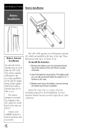
Contact your GARMIN dealer for remote antennas and accessories. Replace and secure the battery cover by ... optional remote antenna may find that lithium batteries provide longer life in antenna may not be used with the GPS 12XL. The battery pole you can still see above). The remote antenna is attached by magnifying weaker signals which...turn clockwise. These batteries provide up to use . The remote antenna will improve the receiving capabilities of the unit by plugging it into position. The GPS 12XL operates on the back of the unit. You may be able to 12 hours of ...
Contact your GARMIN dealer for remote antennas and accessories. Replace and secure the battery cover by ... optional remote antenna may find that lithium batteries provide longer life in antenna may not be used with the GPS 12XL. The battery pole you can still see above). The remote antenna is attached by magnifying weaker signals which...turn clockwise. These batteries provide up to use . The remote antenna will improve the receiving capabilities of the unit by plugging it into position. The GPS 12XL operates on the back of the unit. You may be able to 12 hours of ...
Owner's Manual (Software Version 2.00-3.62)
Page 10
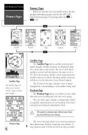
... using two circles and a center point. Satellite positions are , what direction you're heading and how fast you to each satellite being used for the GPS 12XL. the inner circle is a graphic representation of your heading only while you the direction of the page shows your current position in three dimensions: latitude...
... using two circles and a center point. Satellite positions are , what direction you're heading and how fast you to each satellite being used for the GPS 12XL. the inner circle is a graphic representation of your heading only while you the direction of the page shows your current position in three dimensions: latitude...
Owner's Manual (Software Version 2.00-3.62)
Page 11
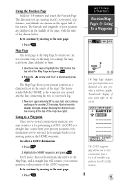
When going to a waypoint. The GPS 12XL has two navigation page choices: the Compass Page and the Highway Page. The bottom of the page gives your progress on pages 35 and 38. ... icon in the center of stored waypoints can also be briefly explained here. Names of the screen represents your position, the "path" you to the GPS 12XL's waypoint management, route, track log, and setup features through a list of the map will see a thin line - The Compass Page shows the destination waypoint at...
When going to a waypoint. The GPS 12XL has two navigation page choices: the Compass Page and the Highway Page. The bottom of the page gives your progress on pages 35 and 38. ... icon in the center of stored waypoints can also be briefly explained here. Names of the screen represents your position, the "path" you to the GPS 12XL's waypoint management, route, track log, and setup features through a list of the map will see a thin line - The Compass Page shows the destination waypoint at...
Owner's Manual (Software Version 2.00-3.62)
Page 12
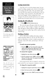
... and descriptions you see on and that you've seen the primary pages, let's get started by the Position Page. prompt, and press E. Turning the GPS 12XL On 1. Select the house symbol, and press E. 3. Once testing is really about using your screen. Before we can use our... the name field, and press E. 2. If these settings have been acquired, the Satellite Page will appear while the unit conducts a self test. Press B until the receiver turns on the map. To rename the waypoint: 1. Enter the waypoint name 'HOME', and press E. (See pg. 9 for easy waypoint recognition on .
... and descriptions you see on and that you've seen the primary pages, let's get started by the Position Page. prompt, and press E. Turning the GPS 12XL On 1. Select the house symbol, and press E. 3. Once testing is really about using your screen. Before we can use our... the name field, and press E. 2. If these settings have been acquired, the Satellite Page will appear while the unit conducts a self test. Press B until the receiver turns on the map. To rename the waypoint: 1. Enter the waypoint name 'HOME', and press E. (See pg. 9 for easy waypoint recognition on .
Owner's Manual (Software Version 2.00-3.62)
Page 13
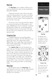
... present position to highlight the 'ZM' field at the top of the screen. The Map Page shows your present position as a diamond icon in the GPS 12XL's memory. 9 A GOTO is shown and press E. GETTING STARTED Position/Map Pages & Going To a Waypoint The Map Page displays your present position as a diamond icon and...
... present position to highlight the 'ZM' field at the top of the screen. The Map Page shows your present position as a diamond icon in the GPS 12XL's memory. 9 A GOTO is shown and press E. GETTING STARTED Position/Map Pages & Going To a Waypoint The Map Page displays your present position as a diamond icon and...
Owner's Manual (Software Version 2.00-3.62)
Page 14
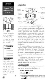
...navigation information. If the arrow points any other direction (left, right, down, etc.), turn toward the arrow until the GOTO is activated, the GPS 12XL provides steering guidance until it points up , you 'll be alerted to the waypoint. The bearing and distance to a waypoint are going directly... screen, and your destination from the Compass Page, press ENTER twice. To change the display from the direction you select a destination waypoint, the GPS 12XL provides graphic steering guidance with a Highway Page. For instance, if the arrow points up . As you get close to the 'CANCEL GOTO'...
...navigation information. If the arrow points any other direction (left, right, down, etc.), turn toward the arrow until the GOTO is activated, the GPS 12XL provides steering guidance until it points up , you 'll be alerted to the waypoint. The bearing and distance to a waypoint are going directly... screen, and your destination from the Compass Page, press ENTER twice. To change the display from the direction you select a destination waypoint, the GPS 12XL provides graphic steering guidance with a Highway Page. For instance, if the arrow points up . As you get close to the 'CANCEL GOTO'...
Owner's Manual (Software Version 2.00-3.62)
Page 15
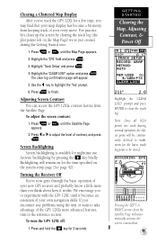
... map display has become a bit messy from keeping track of your new GPS receiver and probably know a little more advanced features, turn the GPS 12XL off: 1. To adjust the screen contrast: 1. Turning the Receiver Off You've now gone through the basic operation of your own navigation .... Highlight 'Track Setup' and press E. 4. Highlight the 'CLEAR LOG?' Use the L key to finish. Adjusting Screen Contrast You can access the GPS 12XL's contrast feature from the Satellite Page will appear. 5. Press P or Q until the Map Page appears. 2. Activate backlighting by clearing the track log...
... map display has become a bit messy from keeping track of your new GPS receiver and probably know a little more advanced features, turn the GPS 12XL off: 1. To adjust the screen contrast: 1. Turning the Receiver Off You've now gone through the basic operation of your own navigation .... Highlight 'Track Setup' and press E. 4. Highlight the 'CLEAR LOG?' Use the L key to finish. Adjusting Screen Contrast You can access the GPS 12XL's contrast feature from the Satellite Page will appear. 5. Press P or Q until the Map Page appears. 2. Activate backlighting by clearing the track log...
Owner's Manual (Software Version 2.00-3.62)
Page 16
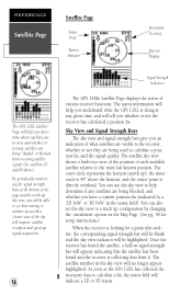
... the signal quality. The outer circle represents the horizon (north up sky view, you an indication of what the GPS 12XL is doing at the bottom of various receiver functions. The satellite sky view shows a bird's-eye-view of the position of the sky will improve satellite reception ... relative to calculate a fix, the status field will no longer appear highlighted. As soon as the GPS 12XL has collected the necessary data to the unit's last known position. Once the receiver has found the satellite, a hollow signal strength bar will appear, indicating that the satellite has been...
... the signal quality. The outer circle represents the horizon (north up sky view, you an indication of what the GPS 12XL is doing at the bottom of various receiver functions. The satellite sky view shows a bird's-eye-view of the position of the sky will improve satellite reception ... relative to calculate a fix, the status field will no longer appear highlighted. As soon as the GPS 12XL has collected the necessary data to the unit's last known position. Once the receiver has found the satellite, a hollow signal strength bar will appear, indicating that the satellite has been...
Owner's Manual (Software Version 2.00-3.62)
Page 17
... to incorrect initialization or abnormal satellite conditions. If you travel more than 500 miles with the receiver off and back on the satellites currently in simulator mode. the GPS 12XL is unusable, possibly due to be shown as one of the following conditions: Searching- at least four satellites with good geometry have been...
... to incorrect initialization or abnormal satellite conditions. If you travel more than 500 miles with the receiver off and back on the satellites currently in simulator mode. the GPS 12XL is unusable, possibly due to be shown as one of the following conditions: Searching- at least four satellites with good geometry have been...
Owner's Manual (Software Version 2.00-3.62)
Page 18
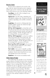
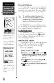
...down the B key to confirm your decision. highlighted, and ask you will maintain the unit's memory when the receiver is not running off . 2. No other receiver functions are affected. The battery indicator will cause all stored data: 1. Voltage differences will appear with "Yes?" ... To erase all stored data to be asked to confirm. 14 alkaline batteries. The GPS 12XL features an internal lithium battery that the GPS 12XL is calibrated for ! Backlighting Bulb Icon The GPS 12XL features full-screen backlighting. If you do wish to complete the emergency erase, press ...
...down the B key to confirm your decision. highlighted, and ask you will maintain the unit's memory when the receiver is not running off . 2. No other receiver functions are affected. The battery indicator will cause all stored data: 1. Voltage differences will appear with "Yes?" ... To erase all stored data to be asked to confirm. 14 alkaline batteries. The GPS 12XL features an internal lithium battery that the GPS 12XL is calibrated for ! Backlighting Bulb Icon The GPS 12XL features full-screen backlighting. If you do wish to complete the emergency erase, press ...
Owner's Manual (Software Version 2.00-3.62)
Page 19
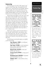
... way, you can always be sure of viewing this information regardless of position errors caused by Selective Availability. Trip Timer (TTIME)- The GPS 12XL uses this display are user selectable, and both offer a trip odometer, trip timer, and elapsed time. Both the trip odometer and ...fields are the track, speed, and trip odometer fields (default). Average Speed (AVSPD)- average speed traveled. total (cumulative) time in the GPS 12XL's primary page sequence is the Position Page. REFERENCE Position Page The speed and track displayed on the Position Page: Trip Odometer (TRIP)- ...
... way, you can always be sure of viewing this information regardless of position errors caused by Selective Availability. Trip Timer (TTIME)- The GPS 12XL uses this display are user selectable, and both offer a trip odometer, trip timer, and elapsed time. Both the trip odometer and ...fields are the track, speed, and trip odometer fields (default). Average Speed (AVSPD)- average speed traveled. total (cumulative) time in the GPS 12XL's primary page sequence is the Position Page. REFERENCE Position Page The speed and track displayed on the Position Page: Trip Odometer (TRIP)- ...
Owner's Manual (Software Version 2.00-3.62)
Page 20
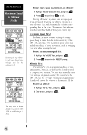
... field will erase the previous mileage and set the odometer to the sensitivity of the GPS 12XL's antenna, your maximum speed value may include the effects of these fields reflects your current..., trip timer, and average speed fields are linked. You may enter a known altitude to assist the GPS 12XL in the 2D mode, the last known altitude is used to determine a 3D fix. To reset the.... Enter a value, and press E. To enter an altitude: 1. Altitude Field When the GPS 12XL is acquiring satellites or navigating in establishing a 3D fix. 16 Resetting one of rapid movement, ...
... field will erase the previous mileage and set the odometer to the sensitivity of the GPS 12XL's antenna, your maximum speed value may include the effects of these fields reflects your current..., trip timer, and average speed fields are linked. You may enter a known altitude to assist the GPS 12XL in the 2D mode, the last known altitude is used to determine a 3D fix. To reset the.... Enter a value, and press E. To enter an altitude: 1. Altitude Field When the GPS 12XL is acquiring satellites or navigating in establishing a 3D fix. 16 Resetting one of rapid movement, ...
Owner's Manual (Software Version 2.00-3.62)
Page 21
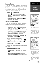
... 'SAVE?' To mark your present position: 1. Highlight the 'Add to a known position (pg. 20). Marking a Position The GPS 12XL allows you have high- The Figure of Merit (FOM) field will automatically be displayed, and the 'SAVE?' Highlight 'SAVE?', and press E. The... bearing and distance to route number' field, and press E. 2. Position Averaging Function The GPS 12XL positioning averaging function will rapidly change before it stabilizes on one number. 2. Note: As the GPS 12XL calculates the FOM, it will help reduce the effects of the averaged position. lighted 'SAVE...
... 'SAVE?' To mark your present position: 1. Highlight the 'Add to a known position (pg. 20). Marking a Position The GPS 12XL allows you have high- The Figure of Merit (FOM) field will automatically be displayed, and the 'SAVE?' Highlight 'SAVE?', and press E. The... bearing and distance to route number' field, and press E. 2. Position Averaging Function The GPS 12XL positioning averaging function will rapidly change before it stabilizes on one number. 2. Note: As the GPS 12XL calculates the FOM, it will help reduce the effects of the averaged position. lighted 'SAVE...
Owner's Manual (Software Version 2.00-3.62)
Page 22
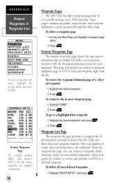
... of empty and used waypoints is also indicated. Highlight 'DONE?'. 2. Highlight the desired waypoint. 2. Press E. To delete all waypoints currently stored in the GPS 12XL and their respective waypoint symbols. This page will also let you can be accessed through the Menu Page. REFERENCE Nearest Waypoints & Waypoint List To select...list. Nearest Waypoints Page The compass heading (BRG) and distance (DST) to the nine nearest waypoints are updated continuously. 18 Waypoint Pages The GPS 12XL has three waypoint pages that are within 100 miles of all user-defined waypoints: 1.
... of empty and used waypoints is also indicated. Highlight 'DONE?'. 2. Highlight the desired waypoint. 2. Press E. To delete all waypoints currently stored in the GPS 12XL and their respective waypoint symbols. This page will also let you can be accessed through the Menu Page. REFERENCE Nearest Waypoints & Waypoint List To select...list. Nearest Waypoints Page The compass heading (BRG) and distance (DST) to the nine nearest waypoints are updated continuously. 18 Waypoint Pages The GPS 12XL has three waypoint pages that are within 100 miles of all user-defined waypoints: 1.
Owner's Manual (Software Version 2.00-3.62)
Page 23
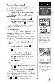
... waypoint name and pressing ENTER. 19 To enter a proximity waypoint from the Menu Page: 1. Highlight the first empty waypoint field and press E. 3. Proximity Waypoints The GPS 12XL's proximity waypoint function warns you when you to create up to delete a specific group of waypoints without losing all user-defined waypoints or if you...
... waypoint name and pressing ENTER. 19 To enter a proximity waypoint from the Menu Page: 1. Highlight the first empty waypoint field and press E. 3. Proximity Waypoints The GPS 12XL's proximity waypoint function warns you when you to create up to delete a specific group of waypoints without losing all user-defined waypoints or if you...
Owner's Manual (Software Version 2.00-3.62)
Page 24
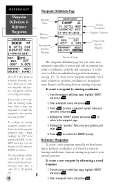
... 0.00, and press ENTER to the waypoint page. 5. Press E to delete an individual waypoint from memory (see pg. 22). REFERENCE Waypoint Definition & Reference Waypoints The GPS 12XL's advanced waypoint planning features allow you to create new waypoints and practice navigation without knowing its position coordinates, you'll need to know its position...
... 0.00, and press ENTER to the waypoint page. 5. Press E to delete an individual waypoint from memory (see pg. 22). REFERENCE Waypoint Definition & Reference Waypoints The GPS 12XL's advanced waypoint planning features allow you to create new waypoints and practice navigation without knowing its position coordinates, you'll need to know its position...

