Owner's Manual (Software Version 2.00-3.62)
Page 5
... 4 Keypad Usage & Data Entry 5 Primary Page Overview 6-7 Power On & Marking a Position 8 Position Page, Map Basics, & Going To A Waypoint 9 Compass Page & Cancelling A GOTO 10 Clearing the Map Display, Screen Contrast, & Power Off 11 SECTION THREE Reference Satellite Page 12-13 Battery Level...Backlighting, and Emergency Erase 14 Position Page & User Selectable Fields 15-16 Marking a Position & Position Averaging Function 17 Waypoint Pages & Managing Waypoints 18-23 TracBack Navigation 24-25 Creating and Using Routes 26-30 Using the Compass & Highway Pages 31-34 Map Page...
... 4 Keypad Usage & Data Entry 5 Primary Page Overview 6-7 Power On & Marking a Position 8 Position Page, Map Basics, & Going To A Waypoint 9 Compass Page & Cancelling A GOTO 10 Clearing the Map Display, Screen Contrast, & Power Off 11 SECTION THREE Reference Satellite Page 12-13 Battery Level...Backlighting, and Emergency Erase 14 Position Page & User Selectable Fields 15-16 Marking a Position & Position Averaging Function 17 Waypoint Pages & Managing Waypoints 18-23 TracBack Navigation 24-25 Creating and Using Routes 26-30 Using the Compass & Highway Pages 31-34 Map Page...
Owner's Manual (Software Version 2.00-3.62)
Page 6
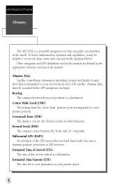
...satel- Desired Track (DTK) The compass course between the "from every GPS satellite. Differential GPS (DGPS) An extension of the GPS system that uses land-based radio beacons to transmit position corrections to " waypoints. Estimated Time Enroute (ETE) The time left to your destination at...receiver from " and "to GPS receivers. Bearing The compass direction from " position (your present speed. 2 Estimated Time of Arrival (ETA) The time of day of your arrival at your starting point) to review the basic terms and concepts briefly explained below. INTRODUCTION Glossary The GPS 12XL...
...satel- Desired Track (DTK) The compass course between the "from every GPS satellite. Differential GPS (DGPS) An extension of the GPS system that uses land-based radio beacons to transmit position corrections to " waypoints. Estimated Time Enroute (ETE) The time left to your destination at...receiver from " and "to GPS receivers. Bearing The compass direction from " position (your present speed. 2 Estimated Time of Arrival (ETA) The time of day of your arrival at your starting point) to review the basic terms and concepts briefly explained below. INTRODUCTION Glossary The GPS 12XL...
Owner's Manual (Software Version 2.00-3.62)
Page 7
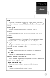
Position An exact, unique location based on a flat surface, using square zones for position measurements. Waypoint A specific location saved in specific zones. Latitude The north/south measurement of position perpendicular to your desired course. ...direction of the destination. Velocity Made Good (VMG) The speed you are traveling in the direction of movement relative to measure position in the receiver's memory. 3 INTRODUCTION Glossary Grid Coordinate system that projects the earth on a geographic coordinate system. Universal Transverse Mercator (UTM) A grid coordinate ...
Position An exact, unique location based on a flat surface, using square zones for position measurements. Waypoint A specific location saved in specific zones. Latitude The north/south measurement of position perpendicular to your desired course. ...direction of the destination. Velocity Made Good (VMG) The speed you are traveling in the direction of movement relative to measure position in the receiver's memory. 3 INTRODUCTION Glossary Grid Coordinate system that projects the earth on a geographic coordinate system. Universal Transverse Mercator (UTM) A grid coordinate ...

Owner's Manual (Software Version 2.00-3.62)
Page 9
... from a submenu page to field. INTRODUCTION Keypad Usage & Data Entry B Turns the unit on and off and activates screen backlighting. G Displays GOTO page with the waypoint highlighted for all data entry. Press E to field. DATA ENTRY The arrow keypad is used for GOTO operation. P Scrolls through the main data pages in...
... from a submenu page to field. INTRODUCTION Keypad Usage & Data Entry B Turns the unit on and off and activates screen backlighting. G Displays GOTO page with the waypoint highlighted for all data entry. Press E to field. DATA ENTRY The arrow keypad is used for GOTO operation. P Scrolls through the main data pages in...
Owner's Manual (Software Version 2.00-3.62)
Page 11
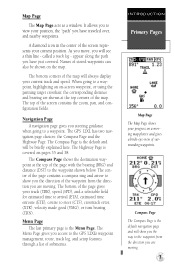
...pages 35 and 38. The center of the page contains a compass ring and arrow to show you the way to the waypoint from the direction you access to the GPS 12XL's waypoint management, route, track log, and setup features through a list of the map. The Menu Page gives you are moving.... Primary Pages Map Page The Map Page shows your position, the "path" you steering guidance when going to the waypoint shown below. called a track log - The GPS 12XL has two navigation page choices: the Compass Page and the Highway Page. Navigation Page A navigation page gives you have just ...
...pages 35 and 38. The center of the page contains a compass ring and arrow to show you the way to the waypoint from the direction you access to the GPS 12XL's waypoint management, route, track log, and setup features through a list of the map. The Menu Page gives you are moving.... Primary Pages Map Page The Map Page shows your position, the "path" you steering guidance when going to the waypoint shown below. called a track log - The GPS 12XL has two navigation page choices: the Compass Page and the Highway Page. Navigation Page A navigation page gives you have just ...
Owner's Manual (Software Version 2.00-3.62)
Page 12
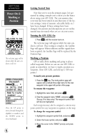
... what you the basics about marking and going to places called waypoints. Once testing is really about using your screen. To rename the waypoint: 1. To change the waypoint symbol: 1. Move the cursor to the 'DONE?' Press B until the receiver turns on and that none of the factory settings ( units ... tour to show you see in the upper-left portion of measure, selectable fields, etc.) have to mark a position as a waypoint. (Your GPS 12XL can hold up to 500 waypoints.) To mark your unit has been turned on . The tour assumes that you've seen the primary pages, let's get started...
... what you the basics about marking and going to places called waypoints. Once testing is really about using your screen. To rename the waypoint: 1. To change the waypoint symbol: 1. Move the cursor to the 'DONE?' Press B until the receiver turns on and that none of the factory settings ( units ... tour to show you see in the upper-left portion of measure, selectable fields, etc.) have to mark a position as a waypoint. (Your GPS 12XL can hold up to 500 waypoints.) To mark your unit has been turned on . The tour assumes that you've seen the primary pages, let's get started...
Owner's Manual (Software Version 2.00-3.62)
Page 13
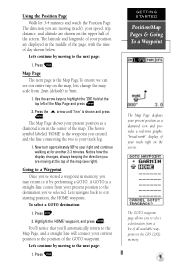
... and the line connecting the two is the Map Page.To ensure we can see right). The house symbol labeled 'HOME' is the waypoint you 've stored a waypoint in the GPS 12XL's memory. 9 Going to the next page: 1. Let's navigate back to highlight the 'ZM' field at the top left of the screen. Highlight...
... and the line connecting the two is the Map Page.To ensure we can see right). The house symbol labeled 'HOME' is the waypoint you 've stored a waypoint in the GPS 12XL's memory. 9 Going to the next page: 1. Let's navigate back to highlight the 'ZM' field at the top left of the screen. Highlight...
Owner's Manual (Software Version 2.00-3.62)
Page 14
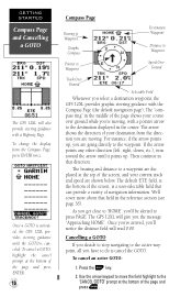
... of the page and press ENTER. 10 Compass Page Bearing to Waypoint Graphic Compass Pointer to Waypoint Destination Waypoint Distance to Waypoint Speed Over Ground Track Over Ground Selectable Field Whenever you select a destination waypoint, the GPS 12XL provides graphic steering guidance with a Highway Page. If the arrow points...the page shows your current track and speed are going directly to the active waypoint, all you 're moving . As you get close to press PAGE. Once a GOTO is activated, the GPS 12XL provides steering guidance until it points up , you 'll be alerted to '...
... of the page and press ENTER. 10 Compass Page Bearing to Waypoint Graphic Compass Pointer to Waypoint Destination Waypoint Distance to Waypoint Speed Over Ground Track Over Ground Selectable Field Whenever you select a destination waypoint, the GPS 12XL provides graphic steering guidance with a Highway Page. If the arrow points...the page shows your current track and speed are going directly to the active waypoint, all you 're moving . As you get close to press PAGE. Once a GOTO is activated, the GPS 12XL provides steering guidance until it points up , you 'll be alerted to '...
Owner's Manual (Software Version 2.00-3.62)
Page 18
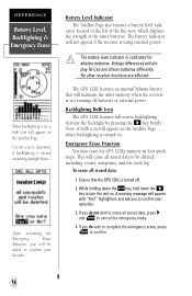
... the GPS 12XL is turned off batteries or external power. Battery Level Indicator The Satellite Page also features a battery level indi- Voltage differences will appear with "Yes?" If you will be deleted, including: routes, waypoints, and the track log. cator, located to confirm. 14 The battery indicator will not appear if the receiver is...
... the GPS 12XL is turned off batteries or external power. Battery Level Indicator The Satellite Page also features a battery level indi- Voltage differences will appear with "Yes?" If you will be deleted, including: routes, waypoints, and the track log. cator, located to confirm. 14 The battery indicator will not appear if the receiver is...
Owner's Manual (Software Version 2.00-3.62)
Page 19
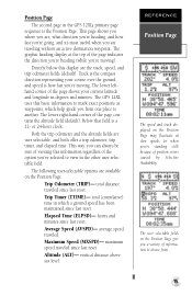
...traveled. maximum speed traveled since last reset. Track is the compass direction representing your current latitude and longitude in degrees and minutes. The GPS 12XL uses this information regardless of the page shows your course over the ground, and speed is how fast you 're moving . Elapsed... you a variety of the page contains the altitude field (default). Altitude (ALT)- Position Page The second page in the GPS 12XL's primary page sequence is a 12- This page shows you where you are traveling without an active destination waypoint. Average Speed (AVSPD)-
...traveled. maximum speed traveled since last reset. Track is the compass direction representing your current latitude and longitude in degrees and minutes. The GPS 12XL uses this information regardless of the page shows your course over the ground, and speed is how fast you 're moving . Elapsed... you a variety of the page contains the altitude field (default). Altitude (ALT)- Position Page The second page in the GPS 12XL's primary page sequence is a 12- This page shows you where you are traveling without an active destination waypoint. Average Speed (AVSPD)-
Owner's Manual (Software Version 2.00-3.62)
Page 21
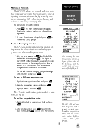
... to a route, enter the desired route number, highlight 'SAVE?' To add the waypoint to route number' field, and press E. 2. and press ENTER. 17 After you have high- Note: As the GPS 12XL calculates the FOM, it will be displayed, and the 'SAVE?' Highlight 'SAVE?', and... press E. field will appear, showing the captured position and a default threedigit name. 2. Highlight the waypoint name field, and press E. 2. Marking a Position The GPS 12XL allows you to mark and store up to a route: 1. REFERENCE Position Averaging After initiating the position averaging function, ...
... to a route, enter the desired route number, highlight 'SAVE?' To add the waypoint to route number' field, and press E. 2. and press ENTER. 17 After you have high- Note: As the GPS 12XL calculates the FOM, it will be displayed, and the 'SAVE?' Highlight 'SAVE?', and... press E. field will appear, showing the captured position and a default threedigit name. 2. Highlight the waypoint name field, and press E. 2. Marking a Position The GPS 12XL allows you to mark and store up to a route: 1. REFERENCE Position Averaging After initiating the position averaging function, ...
Owner's Manual (Software Version 2.00-3.62)
Page 22
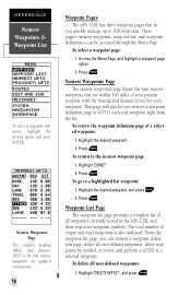
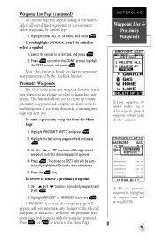
... page provides a complete list of empty and used waypoints is also indicated. REFERENCE Nearest Waypoints & Waypoint List To select a waypoint submenu, highlight the desired option and press ENTER. Nearest Waypoints Page The nearest waypoints page shows the nine nearest waypoints that are updated continuously. 18 Waypoint Pages The GPS 12XL has three waypoint pages that let you quickly manage up to...
... page provides a complete list of empty and used waypoints is also indicated. REFERENCE Nearest Waypoints & Waypoint List To select a waypoint submenu, highlight the desired option and press ENTER. Nearest Waypoints Page The nearest waypoints page shows the nine nearest waypoints that are updated continuously. 18 Waypoint Pages The GPS 12XL has three waypoint pages that let you quickly manage up to...
Owner's Manual (Software Version 2.00-3.62)
Page 23
.... 4. Note: This feature is handy for each waypoint. Proximity Waypoints The GPS 12XL's proximity waypoint function warns you when you 'll be deleted, and press E. 2. Use the U or D key to hazardous waypoints. Press E. To review or remove a proximity waypoint: 1. Quickly edit proximity waypoints by the TracBack function. Press E to select a proximity waypoint and press E. 2. Use U and D to confirm the...
.... 4. Note: This feature is handy for each waypoint. Proximity Waypoints The GPS 12XL's proximity waypoint function warns you when you 'll be deleted, and press E. 2. Use the U or D key to hazardous waypoints. Press E. To review or remove a proximity waypoint: 1. Quickly edit proximity waypoints by the TracBack function. Press E to select a proximity waypoint and press E. 2. Use U and D to confirm the...
Owner's Manual (Software Version 2.00-3.62)
Page 24
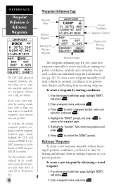
... 'NEW?', and press E. 2. To re-define an existing waypoint's position coordinates from a map, you create new waypoints manually or review and edit an existing waypoint's coordinates, symbols, and comments. Enter a waypoint name, and press E. 3. REFERENCE Waypoint Definition & Reference Waypoints The GPS 12XL's advanced waypoint planning features allow you to create new waypoints and practice navigation without knowing its position coordinates...
... 'NEW?', and press E. 2. To re-define an existing waypoint's position coordinates from a map, you create new waypoints manually or review and edit an existing waypoint's coordinates, symbols, and comments. Enter a waypoint name, and press E. 3. REFERENCE Waypoint Definition & Reference Waypoints The GPS 12XL's advanced waypoint planning features allow you to create new waypoints and practice navigation without knowing its position coordinates...
Owner's Manual (Software Version 2.00-3.62)
Page 25
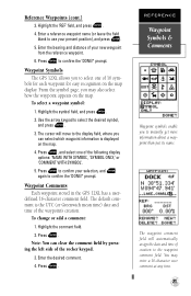
... recognition on the map. Press E to confirm your selection, and E again to use your new waypoint from the reference waypoint. 6. defined 16-character comment field. To change or add a comment: 1. Press E. prompt. Waypoint Comments Each waypoint stored in the GPS 12XL has a user- Highlight the comment field. 2. Enter the desired comment. 4. From the symbol page, you...
... recognition on the map. Press E to confirm your selection, and E again to use your new waypoint from the reference waypoint. 6. defined 16-character comment field. To change or add a comment: 1. Press E. prompt. Waypoint Comments Each waypoint stored in the GPS 12XL has a user- Highlight the comment field. 2. Enter the desired comment. 4. From the symbol page, you...
Owner's Manual (Software Version 2.00-3.62)
Page 26
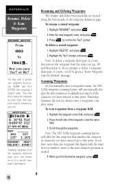
... page gives you find the desired waypoint, press E. 22 Highlight the 'Yes?' Scroll through the waypoints. To rename a stored waypoint: 1. Enter the new waypoint name, and press E. 3. Scanning Waypoints As you manually enter a waypoint's name, the GPS 12XL's waypoint scanning feature will offer the first waypoint that matches the character or characters you have entered up to that begins with...
... page gives you find the desired waypoint, press E. 22 Highlight the 'Yes?' Scroll through the waypoints. To rename a stored waypoint: 1. Enter the new waypoint name, and press E. 3. Scanning Waypoints As you manually enter a waypoint's name, the GPS 12XL's waypoint scanning feature will offer the first waypoint that matches the character or characters you have entered up to that begins with...

Owner's Manual (Software Version 2.00-3.62)
Page 27
...will be overwritten the next time a MOB is activated. REFERENCE Select a GOTO & MOB Function Select a destination waypoint from your present position. Selecting a GOTO Destination The GPS 12XL provides four ways to navigate to the destination until the MOB GOTO is cancelled. Press the G key. 2. ...Man Overboard Function The GPS 12XL's man overboard function (MOB) lets you want to save the MOB waypoint, be sure to rename it because it will overwrite the previous MOB waypoint. 23 Press G twice. Select the waypoint you simultaneously mark and set a course to a...
...will be overwritten the next time a MOB is activated. REFERENCE Select a GOTO & MOB Function Select a destination waypoint from your present position. Selecting a GOTO Destination The GPS 12XL provides four ways to navigate to the destination until the MOB GOTO is cancelled. Press the G key. 2. ...Man Overboard Function The GPS 12XL's man overboard function (MOB) lets you want to save the MOB waypoint, be sure to rename it because it will overwrite the previous MOB waypoint. 23 Press G twice. Select the waypoint you simultaneously mark and set a course to a...
Owner's Manual (Software Version 2.00-3.62)
Page 28
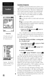
... press E. 2. Note: You may delete a TracBack waypoint from your present position to the oldest track log point in memory. Once a TracBack route is activated, it will be recorded. Once the TracBack function has been activated, the GPS 12XL will be created to mark the most significant features of...and press ENTER to begin TracBack navigation. 24 TracBack Navigation GARMIN's patented TracBack feature allows you to where you back to the oldest track log point stored in the receiver. This feature eliminates the need to mark waypoints along the way and manually create and activate a route...
... press E. 2. Note: You may delete a TracBack waypoint from your present position to the oldest track log point in memory. Once a TracBack route is activated, it will be recorded. Once the TracBack function has been activated, the GPS 12XL will be created to mark the most significant features of...and press ENTER to begin TracBack navigation. 24 TracBack Navigation GARMIN's patented TracBack feature allows you to where you back to the oldest track log point stored in the receiver. This feature eliminates the need to mark waypoints along the way and manually create and activate a route...
Owner's Manual (Software Version 2.00-3.62)
Page 29
...are not contained in routes 1-19. The receiver will then assign the 30 waypoints to the most detailed TracBack route.) • If the receiver is turned off or you will be alerted with a 'waypoint memory full' message, and the receiver will use any available waypoints to create a TracBack route with an ...(the oldest track log point in memory). • If the 'METHOD' option on the track log setup page is activated, the receiver will automatically erase any temporary waypoints that you want to go back to (trail head, truck, etc.). • The 'RECORD' option on pg. 19.) REFERENCE ...
...are not contained in routes 1-19. The receiver will then assign the 30 waypoints to the most detailed TracBack route.) • If the receiver is turned off or you will be alerted with a 'waypoint memory full' message, and the receiver will use any available waypoints to create a TracBack route with an ...(the oldest track log point in memory). • If the 'METHOD' option on the track log setup page is activated, the receiver will automatically erase any temporary waypoints that you want to go back to (trail head, truck, etc.). • The 'RECORD' option on pg. 19.) REFERENCE ...
Owner's Manual (Software Version 2.00-3.62)
Page 30
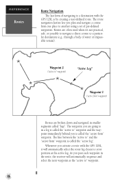
... the active leg. As you activate a route with the GPS 12XL is called the "active from " waypoint is called the "active leg". Waypoint 2 ("active to another using a set of pre-defined waypoints. Routes are broken down and navigated in the route, the receiver will automatically select the route leg closest to your position as the "active...
... the active leg. As you activate a route with the GPS 12XL is called the "active from " waypoint is called the "active leg". Waypoint 2 ("active to another using a set of pre-defined waypoints. Routes are broken down and navigated in the route, the receiver will automatically select the route leg closest to your position as the "active...


