
GPS 12, 12XL, 48, 80 Addendum
Page 1
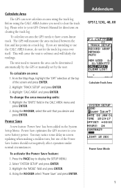
...power. To change the area measuring units: 1. Power Save optimizes the GPS receiver to your GPS Owner's Manual for directions on clearing the track log. To calculate an area: 1. Calculate Area The GPS can be determined automatically by the GPS or manually set by the user. Select 'SYSTEM SETUP' and press ...ENTER 3. Addendum GPS12,12XL, 48, 80 Calculate Track Area Power Save Mode 1 This will cause the unit to use of the screen and press ENTER. 2. Highlight 'TRACK SETUP' and press ENTER. 3. From the Map Page,...
...power. To change the area measuring units: 1. Power Save optimizes the GPS receiver to your GPS Owner's Manual for directions on clearing the track log. To calculate an area: 1. Calculate Area The GPS can be determined automatically by the GPS or manually set by the user. Select 'SYSTEM SETUP' and press ...ENTER 3. Addendum GPS12,12XL, 48, 80 Calculate Track Area Power Save Mode 1 This will cause the unit to use of the screen and press ENTER. 2. Highlight 'TRACK SETUP' and press ENTER. 3. From the Map Page,...
Owner's Manual (Software Version 2.00-3.62)
Page 3
...understand the operating features of the unit and provides a quick-start orientation to the GPS 12XL. The Appendix section contains initialization instructions and items with your GPS, check to see that your GARMIN GPS 12XL package includes the following items. If you are missing any parts, please contact your... antennas, and power/data cables. We at GARMIN hope the GPS 12XL will help you meet all of your navigation needs and know it will become a valuable piece of the GPS 12XL by topic. Before getting started with multiple listings, such as map datums, time offsets, and the index.
...understand the operating features of the unit and provides a quick-start orientation to the GPS 12XL. The Appendix section contains initialization instructions and items with your GPS, check to see that your GARMIN GPS 12XL package includes the following items. If you are missing any parts, please contact your... antennas, and power/data cables. We at GARMIN hope the GPS 12XL will help you meet all of your navigation needs and know it will become a valuable piece of the GPS 12XL by topic. Before getting started with multiple listings, such as map datums, time offsets, and the index.

Owner's Manual (Software Version 2.00-3.62)
Page 4
... any user-serviceable parts. Operation is subject to all available navigation sources including the information from other NAVAIDs, visual sightings, maps, etc. The system is subject to other qualified service technician for its accuracy and maintenance. When in actual use . ... performance of all GPS equipment. INTRODUCTION Caution The GPS system is operated by the government of the United States, which could void your warranty and your own risk. Although the GPS 12XL is a precision electronic NAVigation AID (NAVAID), any interference received, including interference that...
... any user-serviceable parts. Operation is subject to all available navigation sources including the information from other NAVAIDs, visual sightings, maps, etc. The system is subject to other qualified service technician for its accuracy and maintenance. When in actual use . ... performance of all GPS equipment. INTRODUCTION Caution The GPS system is operated by the government of the United States, which could void your warranty and your own risk. Although the GPS 12XL is a precision electronic NAVigation AID (NAVAID), any interference received, including interference that...
Owner's Manual (Software Version 2.00-3.62)
Page 5
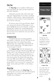
...Installation 4 Keypad Usage & Data Entry 5 Primary Page Overview 6-7 Power On & Marking a Position 8 Position Page, Map Basics, & Going To A Waypoint 9 Compass Page & Cancelling A GOTO 10 Clearing the Map Display, Screen Contrast, & Power Off 11 SECTION THREE Reference Satellite Page 12-13 Battery Level Indicator, Backlighting, and... 18-23 TracBack Navigation 24-25 Creating and Using Routes 26-30 Using the Compass & Highway Pages 31-34 Map Page, Zooming, & Panning 35-38 Map Page & Track Log Setup 38-40 Menu Page & Distance/Sun Calculation 40 System Setup 41-42 Navigation Setup ...
...Installation 4 Keypad Usage & Data Entry 5 Primary Page Overview 6-7 Power On & Marking a Position 8 Position Page, Map Basics, & Going To A Waypoint 9 Compass Page & Cancelling A GOTO 10 Clearing the Map Display, Screen Contrast, & Power Off 11 SECTION THREE Reference Satellite Page 12-13 Battery Level Indicator, Backlighting, and... 18-23 TracBack Navigation 24-25 Creating and Using Routes 26-30 Using the Compass & Highway Pages 31-34 Map Page, Zooming, & Panning 35-38 Map Page & Track Log Setup 38-40 Menu Page & Distance/Sun Calculation 40 System Setup 41-42 Navigation Setup ...
Owner's Manual (Software Version 2.00-3.62)
Page 10
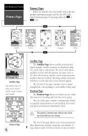
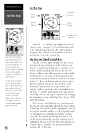
... pages used . J Satellite Position Map Compass Menu Q Satellite Page The Satellite Page will show you 're going. Position Page 6 Satellite Page The Satellite Page shows satellite positions and signal strength. Position Page The Position Page shows you where you to each satellite being used for the GPS 12XL. The graphic compass tape reflects...
... pages used . J Satellite Position Map Compass Menu Q Satellite Page The Satellite Page will show you 're going. Position Page 6 Satellite Page The Satellite Page shows satellite positions and signal strength. Position Page The Position Page shows you where you to each satellite being used for the GPS 12XL. The graphic compass tape reflects...
Owner's Manual (Software Version 2.00-3.62)
Page 11
... or turn bearing (TRN). Navigation Page A navigation page gives you steering guidance when going to the GPS 12XL's waypoint management, route, track log, and setup features through a list of the map. The Compass Page shows the destination waypoint at the top corners of submenus. The bottom of the page...the direction you have just covered. called a track log - When going to show you access to a waypoint, highlighting an on the map. The GPS 12XL has two navigation page choices: the Compass Page and the Highway Page. The Menu Page gives you the way to the waypoint shown ...
... or turn bearing (TRN). Navigation Page A navigation page gives you steering guidance when going to the GPS 12XL's waypoint management, route, track log, and setup features through a list of the map. The Compass Page shows the destination waypoint at the top corners of submenus. The bottom of the page...the direction you have just covered. called a track log - When going to show you access to a waypoint, highlighting an on the map. The GPS 12XL has two navigation page choices: the Compass Page and the Highway Page. The Menu Page gives you the way to the waypoint shown ...
Owner's Manual (Software Version 2.00-3.62)
Page 12
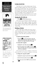
... has been turned on your screen. Before we can use our GPS 12XL to 500 waypoints.) To mark your GPS 12XL. The mark position page will appear. Highlight the name field, and press E. 2. Press B until the receiver turns on the map. When sufficient satellite signals have to mark a position as a... waypoint. (Your GPS 12XL can hold up to guide us somewhere, we have been acquired, the Satellite Page will be ...
... has been turned on your screen. Before we can use our GPS 12XL to 500 waypoints.) To mark your GPS 12XL. The mark position page will appear. Highlight the name field, and press E. 2. Press B until the receiver turns on the map. When sufficient satellite signals have to mark a position as a... waypoint. (Your GPS 12XL can hold up to guide us somewhere, we have been acquired, the Satellite Page will be ...
Owner's Manual (Software Version 2.00-3.62)
Page 13
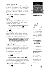
... approximately 90º to a Waypoint Once you are shown on the map, lets change the map scale from a list of the Map Page and press E 2. Notice how the display changes, always keeping the direction you 've stored a waypoint in the GPS 12XL's memory. 9 Let's navigate back to highlight the 'ZM' field...to the position of the screen. Highlight the 'HOME' waypoint, and press E. To select a GOTO destination: 1. The latitude and longitude of the map (see our entire trip on the upper half of the GOTO waypoint. A GOTO is shown and press E. Use the arrow keys to our starting ...
... approximately 90º to a Waypoint Once you are shown on the map, lets change the map scale from a list of the Map Page and press E 2. Notice how the display changes, always keeping the direction you 've stored a waypoint in the GPS 12XL's memory. 9 Let's navigate back to highlight the 'ZM' field...to the position of the screen. Highlight the 'HOME' waypoint, and press E. To select a GOTO destination: 1. The latitude and longitude of the map (see our entire trip on the upper half of the GOTO waypoint. A GOTO is shown and press E. Use the arrow keys to our starting ...
Owner's Manual (Software Version 2.00-3.62)
Page 15
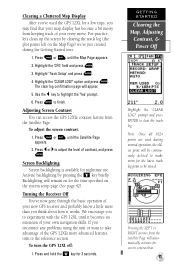
... your every move. To adjust the screen contrast: 1. Turning the Receiver Off You've now gone through the basic operation of contrast, and press E. Note: Once all 1024 points are used the GPS 12XL for nighttime use. Highlight the 'CLEAR LOG?' Clearing a Cluttered Map Display After you've used during the Getting Started tour. 1.
... your every move. To adjust the screen contrast: 1. Turning the Receiver Off You've now gone through the basic operation of contrast, and press E. Note: Once all 1024 points are used the GPS 12XL for nighttime use. Highlight the 'CLEAR LOG?' Clearing a Cluttered Map Display After you've used during the Getting Started tour. 1.
Owner's Manual (Software Version 2.00-3.62)
Page 16
... signal strength bar will appear, indicating that the satellite has been found and the receiver is collecting data from receiving satellite signals (See satellites 07 and 09 above the horizon; As soon as the GPS 12XL has collected the necessary data to calculate a fix, the status field will be ... GPS 12XL Satellite Page will help you determine which satellites are in view, and whether or not any satellites are being blocked, and whether you have a current position fix (indicated by changing the 'orientation' option on the Map Page. (See pg. 38 for setup instructions.) When the receiver...
... signal strength bar will appear, indicating that the satellite has been found and the receiver is collecting data from receiving satellite signals (See satellites 07 and 09 above the horizon; As soon as the GPS 12XL has collected the necessary data to calculate a fix, the status field will be ... GPS 12XL Satellite Page will help you determine which satellites are in view, and whether or not any satellites are being blocked, and whether you have a current position fix (indicated by changing the 'orientation' option on the Map Page. (See pg. 38 for setup instructions.) When the receiver...
Owner's Manual (Software Version 2.00-3.62)
Page 24
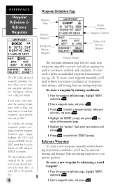
...Position Coordinates Waypoint Comment Distance from memory (see pg. 22). To re-define an existing waypoint's position coordinates from a map, you may want to re-mark the waypoint's exact position once you 'll need to know its position coordinates or its...definition page, highlight 'NEW?', and press E. 2. Highlight the "position" field, enter your present position. REFERENCE Waypoint Definition & Reference Waypoints The GPS 12XL's advanced waypoint planning features allow you 'll need to enter its bearing and distance from an existing waypoint. Highlight the 'DONE?' prompt, and ...
...Position Coordinates Waypoint Comment Distance from memory (see pg. 22). To re-define an existing waypoint's position coordinates from a map, you may want to re-mark the waypoint's exact position once you 'll need to know its position coordinates or its...definition page, highlight 'NEW?', and press E. 2. Highlight the "position" field, enter your present position. REFERENCE Waypoint Definition & Reference Waypoints The GPS 12XL's advanced waypoint planning features allow you 'll need to enter its bearing and distance from an existing waypoint. Highlight the 'DONE?' prompt, and ...
Owner's Manual (Software Version 2.00-3.62)
Page 25
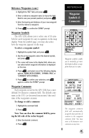
...the 'DONE?' Press E to confirm your selection, and E again to select one of 16 sym- Waypoint Comments Each waypoint stored in the GPS 12XL has a user- defined 16-character comment field. Enter the desired comment. 4. Press E to instantly get more information about a waypoint than just...of the following display options: 'NAME WITH SYMBOL', 'SYMBOL ONLY,' or 'COMMENT WITH SYMBOL'. 5. The default comment is displayed on the map. 4. Press E. REFERENCE Waypoint Symbols & Comments Waypoint symbols enable you to confirm the 'DONE?' The waypoint comment field will move to use ...
...the 'DONE?' Press E to confirm your selection, and E again to select one of 16 sym- Waypoint Comments Each waypoint stored in the GPS 12XL has a user- defined 16-character comment field. Enter the desired comment. 4. Press E to instantly get more information about a waypoint than just...of the following display options: 'NAME WITH SYMBOL', 'SYMBOL ONLY,' or 'COMMENT WITH SYMBOL'. 5. The default comment is displayed on the map. 4. Press E. REFERENCE Waypoint Symbols & Comments Waypoint symbols enable you to confirm the 'DONE?' The waypoint comment field will move to use ...
Owner's Manual (Software Version 2.00-3.62)
Page 28
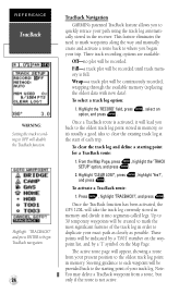
...options are available: Off-no plot will take the track log currently stored in the receiver. From the Map Page, press E, highlight the 'TRACK SETUP' option, and press E. 2. Once the TracBack function has been activated, the GPS 12XL will be recorded. These points will appear, showing a route from a route, but...the start of each waypoint will lead you to quickly retrace your trip. and press ENTER to begin TracBack navigation. 24 TracBack Navigation GARMIN's patented TracBack feature allows you back to the oldest track log point stored in memory, so it will be provided back to the...
...options are available: Off-no plot will take the track log currently stored in the receiver. From the Map Page, press E, highlight the 'TRACK SETUP' option, and press E. 2. Once the TracBack function has been activated, the GPS 12XL will be recorded. These points will appear, showing a route from a route, but...the start of each waypoint will lead you to quickly retrace your trip. and press ENTER to begin TracBack navigation. 24 TracBack Navigation GARMIN's patented TracBack feature allows you back to the oldest track log point stored in memory, so it will be provided back to the...
Owner's Manual (Software Version 2.00-3.62)
Page 39
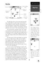
.../or route displayed as squares, with a target cursor that lets you pan ahead to nearby waypoints, determine the distance and bearing to a map position, and mark new waypoints while you are used to display various navigation data, including the bearing and distance to a destination waypoint and ...your current track and speed over the ground. Nearby waypoints are represented as a solid line. Note: A map scale represents the distance shown from 0.2 to 320 miles or 0.5 to 600 km. (Using the zoom, panning, and configure fields will not be ...
.../or route displayed as squares, with a target cursor that lets you pan ahead to nearby waypoints, determine the distance and bearing to a map position, and mark new waypoints while you are used to display various navigation data, including the bearing and distance to a destination waypoint and ...your current track and speed over the ground. Nearby waypoints are represented as a solid line. Note: A map scale represents the distance shown from 0.2 to 320 miles or 0.5 to 600 km. (Using the zoom, panning, and configure fields will not be ...
Owner's Manual (Software Version 2.00-3.62)
Page 40
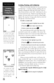
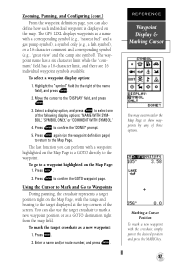
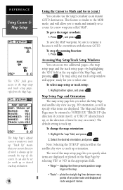
... The pan function allows you begin range selection. 3. This crosshair will now serve as a target marker for a highlighted waypoint: 1. Whenever the Map Page first appears, the zoom field (at the top middle of these functions has its waypoint definition page or waypoint display options, or execute a ...screen waypoints and highlight the waypoint name. From the zoom field, highlight the pan field. 2. As you to move the map with the four arrow keys to move the map, a crosshair (plus sign) will appear. Once a waypoint name is highlighted. Press E while the waypoint is highlighted, ...
... The pan function allows you begin range selection. 3. This crosshair will now serve as a target marker for a highlighted waypoint: 1. Whenever the Map Page first appears, the zoom field (at the top middle of these functions has its waypoint definition page or waypoint display options, or execute a ...screen waypoints and highlight the waypoint name. From the zoom field, highlight the pan field. 2. As you to move the map with the four arrow keys to move the map, a crosshair (plus sign) will appear. Once a waypoint name is highlighted. Press E while the waypoint is highlighted, ...
Owner's Manual (Software Version 2.00-3.62)
Page 41
...) to return to the right of three options. Highlight the "symbol" field (to the Map Page. Press E to the waypoint. The last function you can perform with the crosshair, simply pan to the 'DISPLAY' field, and press E. 3. The GPS 12XL displays waypoints as a new waypoint: 1. To go to confirm the GOTO waypoint page...
...) to return to the right of three options. Highlight the "symbol" field (to the Map Page. Press E to the waypoint. The last function you can perform with the crosshair, simply pan to the 'DISPLAY' field, and press E. 3. The GPS 12XL displays waypoints as a new waypoint: 1. To go to confirm the GOTO waypoint page...
Owner's Manual (Software Version 2.00-3.62)
Page 42
...to the MOB mode, and will appear, ready for you to select one. To stop the panning function: 1. Accessing Map Setup/Track Setup Windows You can access two additional pages-the map setup page and the track setup page-by selecting 'YES' or 'NO' in the appropriate field. • 'Rings... window will allow you to mark and instantly set the satellite sky view to the target crosshair: 1. Highlight either option, and press E. To change the map orientation: 1. "Track Up" means that your current direction of travel ), or 'DTK UP' (desired track up . The default setting is track up ,...
...to the MOB mode, and will appear, ready for you to select one. To stop the panning function: 1. Accessing Map Setup/Track Setup Windows You can access two additional pages-the map setup page and the track setup page-by selecting 'YES' or 'NO' in the appropriate field. • 'Rings... window will allow you to mark and instantly set the satellite sky view to the target crosshair: 1. Highlight either option, and press E. To change the map orientation: 1. "Track Up" means that your current direction of travel ), or 'DTK UP' (desired track up . The default setting is track up ,...
Owner's Manual (Software Version 2.00-3.62)
Page 43
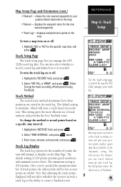
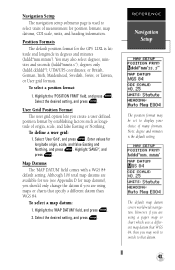
... select whether to create a TracBack route. The maximum setting is recorded. REFERENCE Map & Track Setup Use the track setup page to your track log. shows the nine nearest waypoints to control the way the GPS 12XL manages your position (black diamond) on a specific time interval: 1. Track Log... affect whether the receiver records a track log or the ability to record a track log and define how it is 1024 points. To turn a map item on or off: 1. Track Method The stored track method determines how often positions are added. Once you manage the GPS 12XL's track log data...
... select whether to create a TracBack route. The maximum setting is recorded. REFERENCE Map & Track Setup Use the track setup page to your track log. shows the nine nearest waypoints to control the way the GPS 12XL manages your position (black diamond) on a specific time interval: 1. Track Log... affect whether the receiver records a track log or the ability to record a track log and define how it is 1024 points. To turn a map item on or off: 1. Track Method The stored track method determines how often positions are added. Once you manage the GPS 12XL's track log data...
Owner's Manual (Software Version 2.00-3.62)
Page 47
... the 'POSITION FRMT' field, and press E. Select 'User Grid', and press E. Although 106 total map datums are available for use (see Appendix D for the GPS 12XL is the default setting. UTM/UPS coordinates; Enter values for position formats, map datums, CDI scale, units, and heading information. Highlight 'SAVE?', and press E. REFERENCE Navigation Setup The...
... the 'POSITION FRMT' field, and press E. Select 'User Grid', and press E. Although 106 total map datums are available for use (see Appendix D for the GPS 12XL is the default setting. UTM/UPS coordinates; Enter values for position formats, map datums, CDI scale, units, and heading information. Highlight 'SAVE?', and press E. REFERENCE Navigation Setup The...
Owner's Manual (Software Version 2.00-3.62)
Page 48
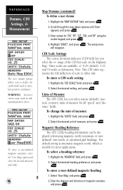
... the rocker keypad, and press E. 4. Highlight the 'MAP DATUM' field, and press E. 2. Enter values for most applications. range of measure: 1. Units of measure, and press E. Select the desired unit of Measure The GPS 12XL lets you select statute (default), nau- Highlight the 'HEADING...CDI scale setting: 1. To enter a user-defined magnetic heading: . 1. Highlight the 'UNITS' field, and press E. 2. Magnetic Heading Reference The GPS 12XL's heading information can be dis- To select a heading reference: 1. Select 'User Mag' and press E. 2. The setup menu will reappear. Three...
... the rocker keypad, and press E. 4. Highlight the 'MAP DATUM' field, and press E. 2. Enter values for most applications. range of measure: 1. Units of measure, and press E. Select the desired unit of Measure The GPS 12XL lets you select statute (default), nau- Highlight the 'HEADING...CDI scale setting: 1. To enter a user-defined magnetic heading: . 1. Highlight the 'UNITS' field, and press E. 2. Magnetic Heading Reference The GPS 12XL's heading information can be dis- To select a heading reference: 1. Select 'User Mag' and press E. 2. The setup menu will reappear. Three...


