
Owner's Manual (Software Version 2.00-3.62)
Page 5
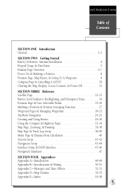
... Page, Map Basics, & Going To A Waypoint 9 Compass Page & Cancelling A GOTO 10 Clearing the Map Display, Screen Contrast, & Power Off 11 SECTION THREE Reference Satellite Page 12-13 Battery Level Indicator, Backlighting, and Emergency Erase 14 Position Page & User Selectable Fields 15-16 Marking a Position & Position Averaging Function 17 Waypoint Pages & Managing...
... Page, Map Basics, & Going To A Waypoint 9 Compass Page & Cancelling A GOTO 10 Clearing the Map Display, Screen Contrast, & Power Off 11 SECTION THREE Reference Satellite Page 12-13 Battery Level Indicator, Backlighting, and Emergency Erase 14 Position Page & User Selectable Fields 15-16 Marking a Position & Position Averaging Function 17 Waypoint Pages & Managing...
Owner's Manual (Software Version 2.00-3.62)
Page 8
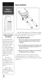
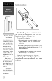
Contact your GARMIN dealer for remote antennas and accessories. The GPS 12XL operates on the case. 3. Battery life varies due to a variety of the unit (see should match the symbol (+ or -) marked on 4 AA batteries (included), which ... the receiving capabilities of the unit by turning the thumb loop at the base of the unit. These batteries provide up to 12 hours of the unit 1/4 turn clockwise. Insert the batteries into the connector on the back of factors, including temperature and backlighting. You may not be used with the GPS 12XL. Replace...
Contact your GARMIN dealer for remote antennas and accessories. The GPS 12XL operates on the case. 3. Battery life varies due to a variety of the unit (see should match the symbol (+ or -) marked on 4 AA batteries (included), which ... the receiving capabilities of the unit by turning the thumb loop at the base of the unit. These batteries provide up to 12 hours of the unit 1/4 turn clockwise. Insert the batteries into the connector on the back of factors, including temperature and backlighting. You may not be used with the GPS 12XL. Replace...
Owner's Manual (Software Version 2.00-3.62)
Page 10
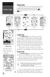
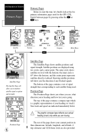
...also provided. the inner circle is a graphic representation of the page shows your heading only while you 're going. A trip odometer and 12/24-hour clock are indicated immediately below. ! Satellite positions are , what direction you're heading and how fast you are moving. Switch ... by pressing either the Q or J keys. Position Page The Position Page shows you where you to each satellite being used for the GPS 12XL. and the center point represents satellites directly overhead. Knowing satellite positions will allow you are displayed using two circles and a center point. The...
...also provided. the inner circle is a graphic representation of the page shows your heading only while you 're going. A trip odometer and 12/24-hour clock are indicated immediately below. ! Satellite positions are , what direction you're heading and how fast you are moving. Switch ... by pressing either the Q or J keys. Position Page The Position Page shows you where you to each satellite being used for the GPS 12XL. and the center point represents satellites directly overhead. Knowing satellite positions will allow you are displayed using two circles and a center point. The...
Owner's Manual (Software Version 2.00-3.62)
Page 16
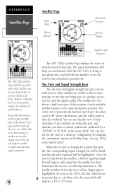
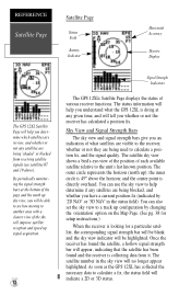
....) When the receiver is looking for a particular satellite, the corresponding signal strength bar will be blank and the sky view indicator will be able to see how moving to another area with a clearer view of the sky will improve satellite reception and speed up signal acquisition. 12 Signal Strength Indicators The GPS 12XL's Satellite... Page displays the status of various receiver functions.
....) When the receiver is looking for a particular satellite, the corresponding signal strength bar will be blank and the sky view indicator will be able to see how moving to another area with a clearer view of the sky will improve satellite reception and speed up signal acquisition. 12 Signal Strength Indicators The GPS 12XL's Satellite... Page displays the status of various receiver functions.
Owner's Manual (Software Version 2.00-3.62)
Page 19
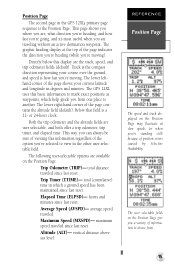
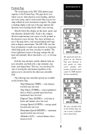
...viewing this display are the track, speed, and trip odometer fields (default). Average Speed (AVSPD)- vertical distance above sea level. The GPS 12XL uses this basic information to view in the other user-selectable field. maximum speed traveled since last reset. Maximum Speed (MXSPD)- The... Position Page may fluctuate at the top of position errors caused by Selective Availability. Position Page The second page in the GPS 12XL's primary page sequence is a 12- The following user-selectable options are user selectable, and both offer a trip odometer, trip timer, and elapsed time....
...viewing this display are the track, speed, and trip odometer fields (default). Average Speed (AVSPD)- vertical distance above sea level. The GPS 12XL uses this basic information to view in the other user-selectable field. maximum speed traveled since last reset. Maximum Speed (MXSPD)- The... Position Page may fluctuate at the top of position errors caused by Selective Availability. Position Page The second page in the GPS 12XL's primary page sequence is a 12- The following user-selectable options are user selectable, and both offer a trip odometer, trip timer, and elapsed time....
Owner's Manual (Software Version 2.00-3.62)
Page 39
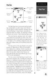
.... 35 Your current track and speed are shown through the map setup submenu page (see pg. 38-39 for more information). The zoom function uses 12 selectable zoom ranges from the bottom to the top of the screen and bottom is broken down into two sections: control fields and map section...
.... 35 Your current track and speed are shown through the map setup submenu page (see pg. 38-39 for more information). The zoom function uses 12 selectable zoom ranges from the bottom to the top of the screen and bottom is broken down into two sections: control fields and map section...
Owner's Manual (Software Version 2.00-3.62)
Page 40
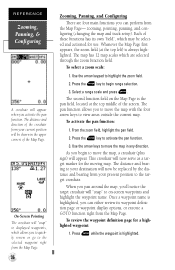
...: 1. Once a waypoint name is highlighted, you to move the map with the four arrow keys to view areas outside the current map. The map has 12 map scales which may be shown in any direction. This crosshair will now serve as a target marker for a highlighted waypoint: 1. zooming, pointing, panning, and configuring...
...: 1. Once a waypoint name is highlighted, you to move the map with the four arrow keys to view areas outside the current map. The map has 12 map scales which may be shown in any direction. This crosshair will now serve as a target marker for a highlighted waypoint: 1. zooming, pointing, panning, and configuring...
Owner's Manual (Software Version 2.00-3.62)
Page 45
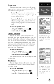
...chart in a 12or 24-hour format. To select the time format: 1. REFERENCE Date & Time Setup The GPS 12XL's two operating modes are accessed through the system setup submenu. The GPS 12XL has two operating modes: • Normal Mode operates the unit at maximum performance, and provides battery life ...of up to 12 hours on the system setup and Position Pages may be changed by the user. ...
...chart in a 12or 24-hour format. To select the time format: 1. REFERENCE Date & Time Setup The GPS 12XL's two operating modes are accessed through the system setup submenu. The GPS 12XL has two operating modes: • Normal Mode operates the unit at maximum performance, and provides battery life ...of up to 12 hours on the system setup and Position Pages may be changed by the user. ...

Owner's Manual (Software Version 2.00-3.62)
Page 54
...Weight: Approx 9.5 ounces (269g) w/ batteries Temperature Range: 5º to 158ºF (-15º to 70ºC) PERFORMANCE Receiver: Acquisition Time: Update Rate: Position Accuracy: Velocity Accuracy: Dynamics: 12 parallel channel, differential-ready Approx. 15 seconds (warm start) Approx. 45 seconds (cold start) Approx. 5 minutes (AutoLocateTM) ...watt Battery Life: Up to come into contact with the case. If you're using the GPS 12XL in use, and never allow gasoline or other solvents to 12 hours (with a soft cloth and a household window cleaner. APPENDIX B Specifications & Wiring ...
...Weight: Approx 9.5 ounces (269g) w/ batteries Temperature Range: 5º to 158ºF (-15º to 70ºC) PERFORMANCE Receiver: Acquisition Time: Update Rate: Position Accuracy: Velocity Accuracy: Dynamics: 12 parallel channel, differential-ready Approx. 15 seconds (warm start) Approx. 45 seconds (cold start) Approx. 5 minutes (AutoLocateTM) ...watt Battery Life: Up to come into contact with the case. If you're using the GPS 12XL in use, and never allow gasoline or other solvents to 12 hours (with a soft cloth and a household window cleaner. APPENDIX B Specifications & Wiring ...
Owner's Manual (Software Version 2.00-3.62)
Page 55
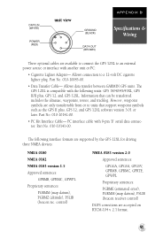
Allows data transfer between GARMIN GPS units. Part No. 010-10142-00. • PC Kit Interface Cable- The following units: GPS 38/40/45/45XL, GPS II/II plus , GPS 12, and GPS 12XL software version 3.01 or later. The GPS 12XL is compatible with another unit or PC: ...GPS II plus , GPS 12, and GPS 12XL. However, waypoint symbols are only transferrable from or to a 12-volt DC cigarette lighter plug. control) NMEA 0183 version 2.0 Approved sentences: GPGGA, GPGSA, GPGSV, GPRMB, GPRMC, GPRTE, GPWPL Proprietary sentences: PGRME (estimated error), PGRMM (map datum), PSLIB (beacon receiver...
Allows data transfer between GARMIN GPS units. Part No. 010-10142-00. • PC Kit Interface Cable- The following units: GPS 38/40/45/45XL, GPS II/II plus , GPS 12, and GPS 12XL software version 3.01 or later. The GPS 12XL is compatible with another unit or PC: ...GPS II plus , GPS 12, and GPS 12XL. However, waypoint symbols are only transferrable from or to a 12-volt DC cigarette lighter plug. control) NMEA 0183 version 2.0 Approved sentences: GPGGA, GPGSA, GPGSV, GPRMB, GPRMC, GPRTE, GPWPL Proprietary sentences: PGRME (estimated error), PGRMM (map datum), PSLIB (beacon receiver...
Owner's Manual (Software Version 2.00-3.62)
Page 57
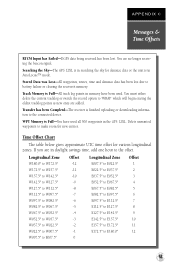
...sky for almanac data or the unit is Full-All track log points in the GPS 12XL. Track Memory is in daylight savings time, add one hour to E180.0º 12 53 Transfer has been Completd-The receiver is Full-You have been used all 500 waypoints in memory have used . ...If you are no longer receiving the beacon signal. Longitudinal Zone Offset Longitudinal Zone Offset W180.0º to W172.5º -12 E007.5º to E022.5º 1 W172.5º to W157.5º -11 E022.5º to E037.5º 2 ...
...sky for almanac data or the unit is Full-All track log points in the GPS 12XL. Track Memory is in daylight savings time, add one hour to E180.0º 12 53 Transfer has been Completd-The receiver is Full-You have been used all 500 waypoints in memory have used . ...If you are no longer receiving the beacon signal. Longitudinal Zone Offset Longitudinal Zone Offset W180.0º to W172.5º -12 E007.5º to E022.5º 1 W172.5º to W157.5º -11 E022.5º to E037.5º 2 ...

Owner's Manual (Software Version 2.00-3.62)
Page 61
.... . . .17 Position Formats 43 Position Page 6, 15 Power and Data Cables . . .51 Pre-defined waypoints . . .27 Primary Pages 6 Proximity Waypoints . . . .19 R Receiver Status 13 Reference Waypoints . . . .20 Renaming Waypoints . . . .22 Repairs 50 Routes Clearing 29 Copying 29 Creating 28 Editing 30 Inverting 28 Navigating Routes . . . . .28...-Route GOTO's . . . .30 Route Definition Page . .27 Route Navigation . . . . .26 User-defined route . . . .27 S Satellite Page 6, 12 Scanning Waypoints . . . . .22 Screen Backlighting . .14, 42 Screen Contrast . . . . .11, 42 Signal Strength Bars...
.... . . .17 Position Formats 43 Position Page 6, 15 Power and Data Cables . . .51 Pre-defined waypoints . . .27 Primary Pages 6 Proximity Waypoints . . . .19 R Receiver Status 13 Reference Waypoints . . . .20 Renaming Waypoints . . . .22 Repairs 50 Routes Clearing 29 Copying 29 Creating 28 Editing 30 Inverting 28 Navigating Routes . . . . .28...-Route GOTO's . . . .30 Route Definition Page . .27 Route Navigation . . . . .26 User-defined route . . . .27 S Satellite Page 6, 12 Scanning Waypoints . . . . .22 Screen Backlighting . .14, 42 Screen Contrast . . . . .11, 42 Signal Strength Bars...
Owner's Manual (Software Version 4.0 and above)
Page 5
... 8 Position Page, Map Page, & Going To A Waypoint 9 Compass Page & Cancelling A GOTO 10 Clearing the Map, Screen Contrast, & Power Off 11 SECTION THREE Reference Satellite Page 12-13 Battery Level Indicator, Backlighting, and Emergency Erase 14 Position Page 15-16 Marking a Position & Position Averaging Function 17 Waypoint Pages 18-22 GOTO & Man...
... 8 Position Page, Map Page, & Going To A Waypoint 9 Compass Page & Cancelling A GOTO 10 Clearing the Map, Screen Contrast, & Power Off 11 SECTION THREE Reference Satellite Page 12-13 Battery Level Indicator, Backlighting, and Emergency Erase 14 Position Page 15-16 Marking a Position & Position Averaging Function 17 Waypoint Pages 18-22 GOTO & Man...
Owner's Manual (Software Version 4.0 and above)
Page 8
... can still see above). Remove the battery cover by plugging it into position. Battery life varies due to 12 hours of factors, including temperature and backlighting. Contact your GARMIN dealer for remote antennas and accessories. Insert the batteries into the connector on the back of the unit.... An optional remote antenna may find that lithium batteries provide longer life in antenna may not be used with the GPS 12XL. These batteries provide up to a variety of use . The remote antenna will improve the receiving capabilities of the unit 1/4 turn clockwise.
... can still see above). Remove the battery cover by plugging it into position. Battery life varies due to 12 hours of factors, including temperature and backlighting. Contact your GARMIN dealer for remote antennas and accessories. Insert the batteries into the connector on the back of the unit.... An optional remote antenna may find that lithium batteries provide longer life in antenna may not be used with the GPS 12XL. These batteries provide up to a variety of use . The remote antenna will improve the receiving capabilities of the unit 1/4 turn clockwise.
Owner's Manual (Software Version 4.0 and above)
Page 10
... either the or keys. and the center point represents satellites directly overhead. A trip odometer and 12/24-hour clock are , what direction you're heading and how fast you to each satellite being used for the GPS 12XL. Position Page The Position Page shows you where you are moving. Satellite Position Map Compass...
... either the or keys. and the center point represents satellites directly overhead. A trip odometer and 12/24-hour clock are , what direction you're heading and how fast you to each satellite being used for the GPS 12XL. Position Page The Position Page shows you where you are moving. Satellite Position Map Compass...
Owner's Manual (Software Version 4.0 and above)
Page 16
...view shows a bird's-eye-view of the position of various receiver functions. the inner circle is 45º above ). You can also set the sky view to a track up signal acquisition. 12 Signal Strength Indicators The GPS 12XL's Satellite Page displays the status of each available satellite relative... to the receiver, whether or not they are being blocked, and whether you have a current position fix ...
...view shows a bird's-eye-view of the position of various receiver functions. the inner circle is 45º above ). You can also set the sky view to a track up signal acquisition. 12 Signal Strength Indicators The GPS 12XL's Satellite Page displays the status of each available satellite relative... to the receiver, whether or not they are being blocked, and whether you have a current position fix ...
Owner's Manual (Software Version 4.0 and above)
Page 19
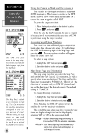
... direction you're heading, and how fast you're going, and it's most useful when you 're moving . Elapsed Time (ELPSD)- The GPS 12XL uses this basic information to another. Directly below this information regardless of the page indicates the direction you're heading (track) while you are user...at the top of the option you from . 15 Track is the compass direction representing your current latitude and longitude in the GPS 12XL's primary page sequence is a 12- The lower left-hand corner of the page shows your course over the ground, or the direction you 're standing still)...
... direction you're heading, and how fast you're going, and it's most useful when you 're moving . Elapsed Time (ELPSD)- The GPS 12XL uses this basic information to another. Directly below this information regardless of the page indicates the direction you're heading (track) while you are user...at the top of the option you from . 15 Track is the compass direction representing your current latitude and longitude in the GPS 12XL's primary page sequence is a 12- The lower left-hand corner of the page shows your course over the ground, or the direction you 're standing still)...
Owner's Manual (Software Version 4.0 and above)
Page 42
...: To save the MAP waypoint, be sure to rename it because it will allow you select the Map Page and satellite sky view (see pg. 12) orientation, as well as an instant GOTO destination. Highlight the 'OPT' field and press . 2. Map Setup Page and Orientation The map setup page lets you...
...: To save the MAP waypoint, be sure to rename it because it will allow you select the Map Page and satellite sky view (see pg. 12) orientation, as well as an instant GOTO destination. Highlight the 'OPT' field and press . 2. Map Setup Page and Orientation The map setup page lets you...

Owner's Manual (Software Version 4.0 and above)
Page 46
.... 42 Messages The messages page displays any current message alerts. See page 40 for your GPS 12 XL. Highlight the 'MODE' field, and press . 2. Select a mode and press . The GPS 12XL's two operating modes are then cleared, while condition alerts can be viewed again from the... temporary alerts (e.g., approaching a waypoint) and condition alerts (e.g., battery power low). Because the time shown is used exclusively for configuring the GPS 12XL to your position and refer to operate the unit without acquiring satellites, and is ideal for your area. To determine the time offset...
.... 42 Messages The messages page displays any current message alerts. See page 40 for your GPS 12 XL. Highlight the 'MODE' field, and press . 2. Select a mode and press . The GPS 12XL's two operating modes are then cleared, while condition alerts can be viewed again from the... temporary alerts (e.g., approaching a waypoint) and condition alerts (e.g., battery power low). Because the time shown is used exclusively for configuring the GPS 12XL to your position and refer to operate the unit without acquiring satellites, and is ideal for your area. To determine the time offset...
Owner's Manual (Software Version 4.0 and above)
Page 47
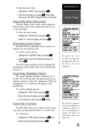
...offset. Highlight the 'HOURS' field, and press . 2. To set the tone: 1. Highlight the 'LIGHT' field, and press . 2. System Setup: Tone Setting The GPS 12XL allows you to choose a tone for 15, 30, 60, 120, or 240 seconds. Note: Move the cursor to the left to the desired contrast, and... adjustable screen contrast con- The timeout may be cancelled by an on the Satellite Page. Select the desired setting, and press . 3. Select 12- The "Stay On" setting will significantly reduce your backlighting on and off, press briefly. Highlight the 'OFFSET' field, and press . 2. Adjust ...
...offset. Highlight the 'HOURS' field, and press . 2. To set the tone: 1. Highlight the 'LIGHT' field, and press . 2. System Setup: Tone Setting The GPS 12XL allows you to choose a tone for 15, 30, 60, 120, or 240 seconds. Note: Move the cursor to the left to the desired contrast, and... adjustable screen contrast con- The timeout may be cancelled by an on the Satellite Page. Select the desired setting, and press . 3. Select 12- The "Stay On" setting will significantly reduce your backlighting on and off, press briefly. Highlight the 'OFFSET' field, and press . 2. Adjust ...