GPS 12, 12XL, 48, 80 Addendum
Page 1
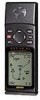
... the 'MODE' field and press ENTER. 4. Addendum GPS12,12XL, 48, 80 Calculate Track Area Power Save Mode 1 Power Save optimizes the GPS receiver to display the SETUP MENU. 2. Calculate Area The GPS can be determined automatically by the GPS or manually set by the user. Highlight 'TRACK SETUP' and press... the Power Save feature: 1. Using the ROCKER, select the unit that you are intending to use of the screen and press ENTER. 2. The GPS will falsify the readings. To calculate an area: 1. Highlight the 'UNITS' field in the System Setup Menu. Press the PAGE key to...
... the 'MODE' field and press ENTER. 4. Addendum GPS12,12XL, 48, 80 Calculate Track Area Power Save Mode 1 Power Save optimizes the GPS receiver to display the SETUP MENU. 2. Calculate Area The GPS can be determined automatically by the GPS or manually set by the user. Highlight 'TRACK SETUP' and press... the Power Save feature: 1. Using the ROCKER, select the unit that you are intending to use of the screen and press ENTER. 2. The GPS will falsify the readings. To calculate an area: 1. Highlight the 'UNITS' field in the System Setup Menu. Press the PAGE key to...
Owner's Manual (Software Version 2.00-3.62)
Page 3
... the operating features of the unit and provides a quick-start orientation to provide quality navigation information in order to see that your GARMIN GPS 12XL package includes the following items. If you are missing any parts, please contact your dealer immediately. i This manual is organized into...in a versatile and user-friendly flexible design you'll enjoy for your outdoor gear. We at GARMIN hope the GPS 12XL will help you meet all of your GARMIN dealer for outdoor use GPS navigator for accessories including our PC kit, swivel mounts, external antennas, and power/data cables....
... the operating features of the unit and provides a quick-start orientation to provide quality navigation information in order to see that your GARMIN GPS 12XL package includes the following items. If you are missing any parts, please contact your dealer immediately. i This manual is organized into...in a versatile and user-friendly flexible design you'll enjoy for your outdoor gear. We at GARMIN hope the GPS 12XL will help you meet all of your GARMIN dealer for outdoor use GPS navigator for accessories including our PC kit, swivel mounts, external antennas, and power/data cables....

Owner's Manual (Software Version 2.00-3.62)
Page 4
... a precision electronic NAVigation AID (NAVAID), any interference received, including interference that interference will not occur in accordance with all available navigation sources including the information from the GPS 12XL to all necessary FCC standards. Unauthorized repairs or modifications... could affect the accuracy and performance of all GPS equipment. The GPS 12XL does not contain any discrepancies before continuing navigation. Although the GPS 12XL is no guarantee that may cause harmful interference to radio communications. This...
... a precision electronic NAVigation AID (NAVAID), any interference received, including interference that interference will not occur in accordance with all available navigation sources including the information from the GPS 12XL to all necessary FCC standards. Unauthorized repairs or modifications... could affect the accuracy and performance of all GPS equipment. The GPS 12XL does not contain any discrepancies before continuing navigation. Although the GPS 12XL is no guarantee that may cause harmful interference to radio communications. This...
Owner's Manual (Software Version 2.00-3.62)
Page 6
...to transmit position corrections to review the basic terms and concepts briefly explained below. Almanac data must be helpful to GPS receivers. Bearing The compass direction from your position to " waypoints. Estimated Time of Arrival (ETA) The time of day of satel...- INTRODUCTION Glossary The GPS 12XL is transmitted to your receiver from every GPS satellite. Almanac Data Satellite constellation information (including location and health of your arrival at your present speed. 2 Other navigation and GPS definitions used in the manual are off a desired...
...to transmit position corrections to review the basic terms and concepts briefly explained below. Almanac data must be helpful to GPS receivers. Bearing The compass direction from your position to " waypoints. Estimated Time of Arrival (ETA) The time of day of satel...- INTRODUCTION Glossary The GPS 12XL is transmitted to your receiver from every GPS satellite. Almanac Data Satellite constellation information (including location and health of your arrival at your present speed. 2 Other navigation and GPS definitions used in the manual are off a desired...
Owner's Manual (Software Version 2.00-3.62)
Page 8
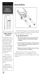
...AA batteries (included), which the built-in colder conditions. 4 The battery pole you can still see above). The remote antenna will improve the receiving capabilities of the unit by turning the thumb loop 1/4 turn counterclockwise. 2. These batteries provide up to 12 hours of the unit. Remove ...the thumb loop at the base of use . The GPS 12XL operates on the case. 3. You may find that lithium batteries provide longer life in antenna may be able to a variety of the unit 1/4 turn clockwise. Contact your GARMIN dealer for remote antennas and accessories. To install the ...
...AA batteries (included), which the built-in colder conditions. 4 The battery pole you can still see above). The remote antenna will improve the receiving capabilities of the unit by turning the thumb loop 1/4 turn counterclockwise. 2. These batteries provide up to 12 hours of the unit. Remove ...the thumb loop at the base of use . The GPS 12XL operates on the case. 3. You may find that lithium batteries provide longer life in antenna may be able to a variety of the unit 1/4 turn clockwise. Contact your GARMIN dealer for remote antennas and accessories. To install the ...
Owner's Manual (Software Version 2.00-3.62)
Page 10
... strength bars corresponding to monitor satellite signal reception and strength. The rest of your heading only while you to each satellite being used for the GPS 12XL.
... strength bars corresponding to monitor satellite signal reception and strength. The rest of your heading only while you to each satellite being used for the GPS 12XL.
Owner's Manual (Software Version 2.00-3.62)
Page 11
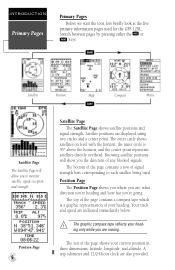
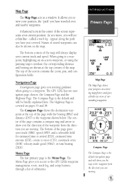
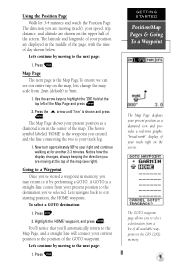
...moving map plotter and gives a bird's-eye-view of stored waypoints can also be briefly explained here. The bottom corners of the map. The GPS 12XL has two navigation page choices: the Compass Page and the Highway Page. The Compass Page shows the destination waypoint at the top corners of ... Page shows your track (TRK), speed (SPD), and a selectable field for estimated time to arrival (ETA), estimated time enroute (ETE), course to the GPS 12XL's waypoint management, route, track log, and setup features through a list of the screen contains the zoom, pan, and configuration fields.
...moving map plotter and gives a bird's-eye-view of stored waypoints can also be briefly explained here. The bottom corners of the map. The GPS 12XL has two navigation page choices: the Compass Page and the Highway Page. The Compass Page shows the destination waypoint at the top corners of ... Page shows your track (TRK), speed (SPD), and a selectable field for estimated time to arrival (ETA), estimated time enroute (ETE), course to the GPS 12XL's waypoint management, route, track log, and setup features through a list of the screen contains the zoom, pan, and configuration fields.
Owner's Manual (Software Version 2.00-3.62)
Page 12
...B until the receiver turns on your present position: 1. The mark position page will appear. Press the M key. Each waypoint may not match what you see on . To change the waypoint symbol: 1. When sufficient satellite signals have to mark a position as a waypoint. (Your GPS 12XL can hold up...Move the cursor to 500 waypoints.) To mark your screen. Highlight the waypoint symbol field, and press E. 2. The tour assumes that your GPS 12XL. Once testing is really about using your unit has been turned on the map. Highlight the name field, and press E. 2. Enter ...
...B until the receiver turns on your present position: 1. The mark position page will appear. Press the M key. Each waypoint may not match what you see on . To change the waypoint symbol: 1. When sufficient satellite signals have to mark a position as a waypoint. (Your GPS 12XL can hold up...Move the cursor to 500 waypoints.) To mark your screen. Highlight the waypoint symbol field, and press E. 2. The tour assumes that your GPS 12XL. Once testing is really about using your unit has been turned on the map. Highlight the name field, and press E. 2. Enter ...
Owner's Manual (Software Version 2.00-3.62)
Page 13
... G. 2. Using the Position Page Walk for another 2-3 minutes. The direction you may return to 5nm. 1. Going to a Waypoint Once you've stored a waypoint in the GPS 12XL's memory. 9 Highlight the 'HOME' waypoint, and press E. The GOTO waypoint page allows you 've selected.
... G. 2. Using the Position Page Walk for another 2-3 minutes. The direction you may return to 5nm. 1. Going to a Waypoint Once you've stored a waypoint in the GPS 12XL's memory. 9 Highlight the 'HOME' waypoint, and press E. The GOTO waypoint page allows you 've selected.
Owner's Manual (Software Version 2.00-3.62)
Page 14
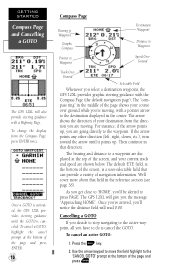
... you are going directly to the waypoint. To cancel a GOTO, highlight the cancel prompt at the bottom of the screen, is activated, the GPS 12XL provides steering guidance until it points up , you 'll notice the distance field will read 0.00. As you get close to 'HOME', you...arrow shows the direction of the screen, and your destination from the Compass Page, press ENTER twice. GETTING STARTED Compass Page and Cancelling a GOTO The GPS 12XL will give you the message "Approaching HOME". Once a GOTO is a user-selectable field that direction. For instance, if the arrow points up ....
... you are going directly to the waypoint. To cancel a GOTO, highlight the cancel prompt at the bottom of the screen, is activated, the GPS 12XL provides steering guidance until it points up , you 'll notice the distance field will read 0.00. As you get close to 'HOME', you...arrow shows the direction of the screen, and your destination from the Compass Page, press ENTER twice. GETTING STARTED Compass Page and Cancelling a GOTO The GPS 12XL will give you the message "Approaching HOME". Once a GOTO is a user-selectable field that direction. For instance, if the arrow points up ....
Owner's Manual (Software Version 2.00-3.62)
Page 15
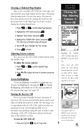
...confirmation page will automatically activate the screen contrast bar. 11 Press Lor Rto adjust the level of your new GPS receiver and probably know a little more advanced features, turn the GPS 12XL off: 1. Pressing the LEFT or RIGHT arrows from the Satellite Page will appear. 5. Highlight the 'CFG'...highlight the 'Yes' prompt. 6. option and press E. Adjusting Screen Contrast You can access the GPS 12XL's contrast feature from keeping track of contrast, and press E. Turning the Receiver Off You've now gone through the basic operation of your map display has become a bit ...
...confirmation page will automatically activate the screen contrast bar. 11 Press Lor Rto adjust the level of your new GPS receiver and probably know a little more advanced features, turn the GPS 12XL off: 1. Pressing the LEFT or RIGHT arrows from the Satellite Page will appear. 5. Highlight the 'CFG'...highlight the 'Yes' prompt. 6. option and press E. Adjusting Screen Contrast You can access the GPS 12XL's contrast feature from keeping track of contrast, and press E. Turning the Receiver Off You've now gone through the basic operation of your map display has become a bit ...
Owner's Manual (Software Version 2.00-3.62)
Page 16
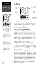
...fix (indicated by changing the 'orientation' option on the Map Page. (See pg. 38 for setup instructions.) When the receiver is collecting data from receiving satellite signals (See satellites 07 and 09 above the horizon; The satellite number in the sky view will tell you understand ...time, and will no longer appear highlighted. The outer circle represents the horizon (north up signal acquisition. 12 Signal Strength Indicators The GPS 12XL's Satellite Page displays the status of each available satellite relative to the unit's last known position. You can also set the sky view...
...fix (indicated by changing the 'orientation' option on the Map Page. (See pg. 38 for setup instructions.) When the receiver is collecting data from receiving satellite signals (See satellites 07 and 09 above the horizon; The satellite number in the sky view will tell you understand ...time, and will no longer appear highlighted. The outer circle represents the horizon (north up signal acquisition. 12 Signal Strength Indicators The GPS 12XL's Satellite Page displays the status of each available satellite relative to the unit's last known position. You can also set the sky view...
Owner's Manual (Software Version 2.00-3.62)
Page 17
... position error, in latitude, longitude and altitude. '3D Diff' will not appear until the GPS 12XL has found the satellites indicated at the top right. Not Usable- the receiver is being calculated in feet or meters) at the bottom of the screen. If you travel...calculate a 2D fix. 2D Nav (2D Navigation)- the GPS 12XL is indoors. at least three satellites with the receiver off and back on the satellites currently in 3D mode. the receiver isn't tracking enough satellites for any satellites are receiving DGPS corrections in searching, AutoLocate, acquiring, simulator, or...
... position error, in latitude, longitude and altitude. '3D Diff' will not appear until the GPS 12XL has found the satellites indicated at the top right. Not Usable- the receiver is being calculated in feet or meters) at the bottom of the screen. If you travel...calculate a 2D fix. 2D Nav (2D Navigation)- the GPS 12XL is indoors. at least three satellites with the receiver off and back on the satellites currently in 3D mode. the receiver isn't tracking enough satellites for any satellites are receiving DGPS corrections in searching, AutoLocate, acquiring, simulator, or...
Owner's Manual (Software Version 2.00-3.62)
Page 18
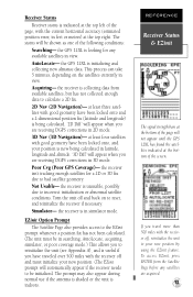
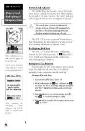
No other receiver functions are affected. Backlighting Bulb Icon The GPS 12XL features full-screen backlighting. If you do wish to complete the emergency erase, press E to confirm. 14 The battery level indicator is using external power....all stored data to be asked to cancel the emergency erase. 4. highlighted, and ask you will cause all stored data: 1. The GPS 12XL features an internal lithium battery that the GPS 12XL is not running off . 2. The battery indicator will appear on the Satellite Page when backlighting is turned on . Emergency Erase Function You...
No other receiver functions are affected. Backlighting Bulb Icon The GPS 12XL features full-screen backlighting. If you do wish to complete the emergency erase, press E to confirm. 14 The battery level indicator is using external power....all stored data to be asked to cancel the emergency erase. 4. highlighted, and ask you will cause all stored data: 1. The GPS 12XL features an internal lithium battery that the GPS 12XL is not running off . 2. The battery indicator will appear on the Satellite Page when backlighting is turned on . Emergency Erase Function You...
Owner's Manual (Software Version 2.00-3.62)
Page 19
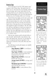
... odometer fields (default). Track is the compass direction representing your current latitude and longitude in the GPS 12XL's primary page sequence is the Position Page. Elapsed Time (ELPSD)- Altitude (ALT)- maximum speed traveled since last reset. The GPS 12XL uses this display are , what direction you're heading, and how fast you're going...
... odometer fields (default). Track is the compass direction representing your current latitude and longitude in the GPS 12XL's primary page sequence is the Position Page. Elapsed Time (ELPSD)- Altitude (ALT)- maximum speed traveled since last reset. The GPS 12XL uses this display are , what direction you're heading, and how fast you're going...
Owner's Manual (Software Version 2.00-3.62)
Page 20
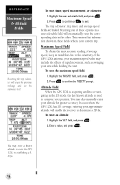
... Field When the GPS 12XL is acquiring satellites or navigating in the 2D mode, the last known altitude is used to confirm the 'RESET?' To enter an altitude: 1. Resetting one of rapid movement, such as swinging your approximate altitude will enable the receiver to 0. This ensures... that due to assist the GPS 12XL in the other. Press E to compute your position. prompt . You may include the effects of these fields reflects...
... Field When the GPS 12XL is acquiring satellites or navigating in the 2D mode, the last known altitude is used to confirm the 'RESET?' To enter an altitude: 1. Resetting one of rapid movement, such as swinging your approximate altitude will enable the receiver to 0. This ensures... that due to assist the GPS 12XL in the other. Press E to compute your position. prompt . You may include the effects of these fields reflects...
Owner's Manual (Software Version 2.00-3.62)
Page 21
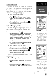
...save new waypoints with a default three-digit name. Press M. Position Averaging Function The GPS 12XL positioning averaging function will rapidly change before it stabilizes on one number. 2. Marking a Position The GPS 12XL allows you have high- After you to mark and store up to a route, enter...route number' field, and press E. 2. To add the waypoint to 500 position as waypoints. The Figure of the averaged position. The GPS 12XL will display the value reflecting estimated accuracy of Merit (FOM) field will save the waypoint. Note: To enter a different waypoint symbol or...
...save new waypoints with a default three-digit name. Press M. Position Averaging Function The GPS 12XL positioning averaging function will rapidly change before it stabilizes on one number. 2. Marking a Position The GPS 12XL allows you have high- After you to mark and store up to a route, enter...route number' field, and press E. 2. To add the waypoint to 500 position as waypoints. The Figure of the averaged position. The GPS 12XL will display the value reflecting estimated accuracy of Merit (FOM) field will save the waypoint. Note: To enter a different waypoint symbol or...
Owner's Manual (Software Version 2.00-3.62)
Page 22
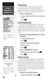
... shows the nine nearest waypoints that let you quickly manage up to the nine nearest waypoints are updated continuously. 18 Waypoint Pages The GPS 12XL has three waypoint pages that are within 100 miles of all user-defined waypoints: 1. Highlight the desired waypoint. 2. Highlight the desired... you retrieve a waypoint definition page or GOTO a selected waypoint right from the list. To delete all waypoints currently stored in the GPS 12XL and their respective waypoint symbols. To review the waypoint definition page of empty and used waypoints is also indicated. Highlight 'DONE?'. 2....
... shows the nine nearest waypoints that let you quickly manage up to the nine nearest waypoints are updated continuously. 18 Waypoint Pages The GPS 12XL has three waypoint pages that are within 100 miles of all user-defined waypoints: 1. Highlight the desired waypoint. 2. Highlight the desired... you retrieve a waypoint definition page or GOTO a selected waypoint right from the list. To delete all waypoints currently stored in the GPS 12XL and their respective waypoint symbols. To review the waypoint definition page of empty and used waypoints is also indicated. Highlight 'DONE?'. 2....
Owner's Manual (Software Version 2.00-3.62)
Page 23
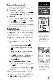
Press E to the Menu Page. Proximity Waypoints The GPS 12XL's proximity waypoint function warns you when you 'll be asked to select a symbol. 1. The distance (DST) field will be deleted, and press E. 2. matically highlighted. Press Q ...
Press E to the Menu Page. Proximity Waypoints The GPS 12XL's proximity waypoint function warns you when you 'll be asked to select a symbol. 1. The distance (DST) field will be deleted, and press E. 2. matically highlighted. Press Q ...
Owner's Manual (Software Version 2.00-3.62)
Page 24
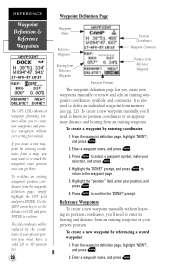
... an individual waypoint from the waypoint definition page, simply highlight the DST field and press ENTER. Press E to confirm. REFERENCE Waypoint Definition & Reference Waypoints The GPS 12XL's advanced waypoint planning features allow you 'll need to enter its approximate distance and bearing from an existing waypoint. Use the LEFT arrow key to...
... an individual waypoint from the waypoint definition page, simply highlight the DST field and press ENTER. Press E to confirm. REFERENCE Waypoint Definition & Reference Waypoints The GPS 12XL's advanced waypoint planning features allow you 'll need to enter its approximate distance and bearing from an existing waypoint. Use the LEFT arrow key to...

