

Owner's Manual
Page 8
... signals. Registering Your Device • Go to http://www.garmin.com/aboutGPS. Satellite Signals After the device is turned on the GPS position. For more information about GPS, go to http://my.garmin.com. • Keep the original sales receipt, or a photocopy, in a safe place. 8 eTrex Owner's Manual The time and date are solid green...
... signals. Registering Your Device • Go to http://www.garmin.com/aboutGPS. Satellite Signals After the device is turned on the GPS position. For more information about GPS, go to http://my.garmin.com. • Keep the original sales receipt, or a photocopy, in a safe place. 8 eTrex Owner's Manual The time and date are solid green...

Owner's Manual
Page 17
...Use the map to navigate to your vehicle. 1. Navigation Compass The eTrex 30 has a 3-axis, electronic compass. Calibrating the Compass Notice Calibrate ... influence magnetic fields, such as cars, buildings, or overhead power lines. • Select a location on the eTrex 20 and eTrex 30. Select Profile Change > Automotive. 2. TIP: When the device is only available on the map, and ...and load City Navigator maps. Follow the turns in your destination. eTrex Owner's Manual 17 Navigating a Driving Route Driving route navigation is using the automotive profile, the compass displays...
...Use the map to navigate to your vehicle. 1. Navigation Compass The eTrex 30 has a 3-axis, electronic compass. Calibrating the Compass Notice Calibrate ... influence magnetic fields, such as cars, buildings, or overhead power lines. • Select a location on the eTrex 20 and eTrex 30. Select Profile Change > Automotive. 2. TIP: When the device is only available on the map, and ...and load City Navigator maps. Follow the turns in your destination. eTrex Owner's Manual 17 Navigating a Driving Route Driving route navigation is using the automotive profile, the compass displays...

Owner's Manual
Page 21
Select an option: • To apply the filter to a computer (page 44). 2. eTrex Owner's Manual 21 Connect your device to the geocache list, select Search. • To save custom filters for hidden treasures using GPS coordinates posted online by those hiding the geocache. Go to your geocache list based on certain factors, such...
Select an option: • To apply the filter to a computer (page 44). 2. eTrex Owner's Manual 21 Connect your device to the geocache list, select Search. • To save custom filters for hidden treasures using GPS coordinates posted online by those hiding the geocache. Go to your geocache list based on certain factors, such...

Owner's Manual
Page 26
...signal strength bar of the screen. 3. Select Turn Alarm On. 4. Satellite Page The satellite page shows your current track toward the top of that satellite (eTrex 20/30). Select Alarm Clock. 2. Select an option. Select Satellite > menu. 2. If the device is off at the alarm time, the device ...turns on at the selected time. Turning Off GPS Select Satellite > menu > Use With GPS Off. 26 eTrex Owner's Manual Applications Setting an Alarm If you are not currently using the device, you can set the time, and select Done....
...signal strength bar of the screen. 3. Select Turn Alarm On. 4. Satellite Page The satellite page shows your current track toward the top of that satellite (eTrex 20/30). Select Alarm Clock. 2. Select an option. Select Satellite > menu. 2. If the device is off at the alarm time, the device ...turns on at the selected time. Turning Off GPS Select Satellite > menu > Use With GPS Off. 26 eTrex Owner's Manual Applications Setting an Alarm If you are not currently using the device, you can set the time, and select Done....

Owner's Manual
Page 27
Select Use. Applications eTrex Owner's Manual 27 Select a location. 4. Simulating a Location Before you can simulate a location, you must turn off GPS (page 26). 1. Select Satellite > menu > Use With GPS Off. 2. Select menu > Set Location On Map. 3.
Select Use. Applications eTrex Owner's Manual 27 Select a location. 4. Simulating a Location Before you can simulate a location, you must turn off GPS (page 26). 1. Select Satellite > menu > Use With GPS Off. 2. Select menu > Set Location On Map. 3.

Owner's Manual
Page 30
...turns off ). Note: To adjust the backlight brightness, see page 40. • Colors (eTrex 20/30)-sets the colors that display in Night and Day mode. ◦◦ Mode-sets a light ...map data, such as street names. • Battery Type-allows you to http://www.garmin.com/ aboutGPS/waas.html. • Language-sets the text language on the device. Select Edit Name...System Settings Select Setup > System. • GPS-sets the GPS to Normal, WAAS/EGNOS (Wide Area Augmentation System/European Geostationary Navigation Overlay Service), or Demo Mode (GPS off . Select Done. note: Changing the ...
...turns off ). Note: To adjust the backlight brightness, see page 40. • Colors (eTrex 20/30)-sets the colors that display in Night and Day mode. ◦◦ Mode-sets a light ...map data, such as street names. • Battery Type-allows you to http://www.garmin.com/ aboutGPS/waas.html. • Language-sets the text language on the device. Select Edit Name...System Settings Select Setup > System. • GPS-sets the GPS to Normal, WAAS/EGNOS (Wide Area Augmentation System/European Geostationary Navigation Overlay Service), or Demo Mode (GPS off . Select Done. note: Changing the ...

Owner's Manual
Page 33
... You can select Automatic to set the time zone automatically based on the map. • Auto Archive-selects an automatic archive method to organize your GPS position. eTrex Owner's Manual 33 Select a unit of the track line on your tracks. Customizing Your Device Time Settings Select Setup > Time. • Time Format-allows... select a 12-hour or a 24-hour display time. • Time Zone-allows you are saved and cleared automatically based on the user setting. • Color (eTrex 20/30)-changes the color of measure for the device.
... You can select Automatic to set the time zone automatically based on the map. • Auto Archive-selects an automatic archive method to organize your GPS position. eTrex Owner's Manual 33 Select a unit of the track line on your tracks. Customizing Your Device Time Settings Select Setup > Time. • Time Format-allows... select a 12-hour or a 24-hour display time. • Time Zone-allows you are saved and cleared automatically based on the user setting. • Color (eTrex 20/30)-changes the color of measure for the device.

Owner's Manual
Page 34
... is using. Select Setup > Heading. • Display-sets the type of directional heading on the eTrex 30. Customizing Your Device • Map Datum-sets the coordinate system on . 34 eTrex Owner's Manual sets the direction to your destination. ◦◦ Course (CDI)-the course deviation indicator...select how the course appears. ◦◦ Bearing (Small or Large)- Select Setup > Altimeter. • Auto Calibration-allows the altimeter to a GPS compass when you are traveling at a higher rate of speed for a set period of the compass. • Go To Line (Pointer)-allows you...
... is using. Select Setup > Heading. • Display-sets the type of directional heading on the eTrex 30. Customizing Your Device • Map Datum-sets the coordinate system on . 34 eTrex Owner's Manual sets the direction to your destination. ◦◦ Course (CDI)-the course deviation indicator...select how the course appears. ◦◦ Bearing (Small or Large)- Select Setup > Altimeter. • Auto Calibration-allows the altimeter to a GPS compass when you are traveling at a higher rate of speed for a set period of the compass. • Go To Line (Pointer)-allows you...

Owner's Manual
Page 47
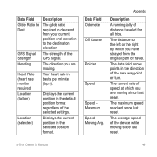
... ANT+ accessory is accurate to within range (10 ft. The total elevation distance ascended. eTrex Owner's Manual 47 Data Field Options Not all data fields are activated and functioning correctly. • When paired, your Garmin device receives data from other accessories. The average vertical distance of GPS Ambient Pressure Ascent Average Ascent Maximum Ascent...
... ANT+ accessory is accurate to within range (10 ft. The total elevation distance ascended. eTrex Owner's Manual 47 Data Field Options Not all data fields are activated and functioning correctly. • When paired, your Garmin device receives data from other accessories. The average vertical distance of GPS Ambient Pressure Ascent Average Ascent Maximum Ascent...
Owner's Manual
Page 49
... speed of travel. The strength of distance traveled for all trips. Appendix Description A running tally of the GPS signal. Your heart rate in the selected position format. eTrex Owner's Manual 49 Displays the current position in the direction of the selected settings. The data field arrow ...Maximum Speed Moving Avg. The distance to Dest. Data Field Glide Ratio to the left or the right by which you are moving. GPS Signal Strength Heading Heart Rate (heart rate monitor required) Location (lat/lon) Location (selected) Description The glide ratio required to descend ...
... speed of travel. The strength of distance traveled for all trips. Appendix Description A running tally of the GPS signal. Your heart rate in the selected position format. eTrex Owner's Manual 49 Displays the current position in the direction of the selected settings. The data field arrow ...Maximum Speed Moving Avg. The distance to Dest. Data Field Glide Ratio to the left or the right by which you are moving. GPS Signal Strength Heading Heart Rate (heart rate monitor required) Location (lat/lon) Location (selected) Description The glide ratio required to descend ...

Owner's Manual
Page 50
L means turn right. R means turn left. The time of day based on your GPS position. The current time of sunrise based on your current course. Trip Time Total A running tally of... last reset. Data Field Description Trip Odometer A running tally of Day Time to Destination Time to your destination and your GPS position. Trip Time Stopped The time spent not moving since the last reset. Velocity Made The speed at which you are...Speed Overall Avg. The estimated time needed to reach the next waypoint on a destination along a route. 50 eTrex Owner's Manual
L means turn right. R means turn left. The time of day based on your GPS position. The current time of sunrise based on your current course. Trip Time Total A running tally of... last reset. Data Field Description Trip Odometer A running tally of Day Time to Destination Time to your destination and your GPS position. Trip Time Stopped The time spent not moving since the last reset. Velocity Made The speed at which you are...Speed Overall Avg. The estimated time needed to reach the next waypoint on a destination along a route. 50 eTrex Owner's Manual
Owner's Manual
Page 53
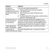
... have several network drives mapped on your computer, Windows may have trouble assigning drive letters to your Garmin external GPS antenna. computer, but it will not 2. If you connect the device to your Garmin parts or accessories. eTrex Owner's Manual 53 Appendix Problem Solution My device is You may have loaded a corrupted file. Continue...
... have several network drives mapped on your computer, Windows may have trouble assigning drive letters to your Garmin external GPS antenna. computer, but it will not 2. If you connect the device to your Garmin parts or accessories. eTrex Owner's Manual 53 Appendix Problem Solution My device is You may have loaded a corrupted file. Continue...

Owner's Manual
Page 55
...9 display backlight timeout 30 screen capture 30 settings 30 downloading geocaches 21 software 40 driving routes 37 E editing profiles 30 routes 12 waypoints 9 eTrex Owner's Manual elevation plot 19, 20 barometric altimeter 20 of a track 15 F file types 43 finding addresses 12 near your location 11 fishing... times 25 fitness options 46 G geocaches 21, 35 downloading 21 filter list 21 logging attempt 22 navigating to 22 settings 35 GPS signals 8, 26, 30, 47, 49, 52 turning off 26 H heading settings 34 HomePort 43 Index hunting times 25 K keys 5, 6 L language 30 locking ...
...9 display backlight timeout 30 screen capture 30 settings 30 downloading geocaches 21 software 40 driving routes 37 E editing profiles 30 routes 12 waypoints 9 eTrex Owner's Manual elevation plot 19, 20 barometric altimeter 20 of a track 15 F file types 43 finding addresses 12 near your location 11 fishing... times 25 fitness options 46 G geocaches 21, 35 downloading 21 filter list 21 logging attempt 22 navigating to 22 settings 35 GPS signals 8, 26, 30, 47, 49, 52 turning off 26 H heading settings 34 HomePort 43 Index hunting times 25 K keys 5, 6 L language 30 locking ...

Owner's Manual
Page 56
... 12 deleting 13 editing 13 navigating 13 settings 36 S satellite signals 8, 26, 47, 49, 52 system settings 30 turning off GPS 26, 27 saving tracks 15 sharing data 24 Sight N' Go 10 software updating 40 version 40 stopwatch 26 storing the device 42 sunrise and sunset times 25, 50 system settings 30... T text size, maps 32 time alarms 26 data fields 50 settings 33 sunrise and sunset 25, 50 zone 33 tones 31 56 eTrex Owner's Manual
... 12 deleting 13 editing 13 navigating 13 settings 36 S satellite signals 8, 26, 47, 49, 52 system settings 30 turning off GPS 26, 27 saving tracks 15 sharing data 24 Sight N' Go 10 software updating 40 version 40 stopwatch 26 storing the device 42 sunrise and sunset times 25, 50 system settings 30... T text size, maps 32 time alarms 26 data fields 50 settings 33 sunrise and sunset 25, 50 zone 33 tones 31 56 eTrex Owner's Manual
Quick Start Manual
Page 4
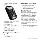
...Satellite Signals After the device is turned on the backlight page (page 5) are set automatically based on the GPS position. eTrex 10 Quick Start Manual Insert the batteries, observing polarity. 3. Replace the battery cover, and turn the D-ring clockwise.... 4. Select Setup > System > Battery Type. 6. Select Alkaline, Lithium, or Rechargeable NiMH. The device may need a clear view of the sky to www.garmin.com/aboutGPS. For more information about GPS...
...Satellite Signals After the device is turned on the backlight page (page 5) are set automatically based on the GPS position. eTrex 10 Quick Start Manual Insert the batteries, observing polarity. 3. Replace the battery cover, and turn the D-ring clockwise.... 4. Select Setup > System > Battery Type. 6. Select Alkaline, Lithium, or Rechargeable NiMH. The device may need a clear view of the sky to www.garmin.com/aboutGPS. For more information about GPS...


