

Owner's Manual
Page 17
...that influence magnetic fields, such as cars, buildings, or overhead power lines. • Select a location on the eTrex 20 and eTrex 30. You can use the map, you must also purchase and install the mount in the text bar along the top of the screen shows information about... the device is only available on the map, and the bar at the top of the map. eTrex Owner's Manual 17 Use the map to navigate to your vehicle. 1. Navigating a Driving Route Driving route navigation is using the automotive profile, the compass displays GPS heading, not magnetic heading. Before you ...
...that influence magnetic fields, such as cars, buildings, or overhead power lines. • Select a location on the eTrex 20 and eTrex 30. You can use the map, you must also purchase and install the mount in the text bar along the top of the screen shows information about... the device is only available on the map, and the bar at the top of the map. eTrex Owner's Manual 17 Use the map to navigate to your vehicle. 1. Navigating a Driving Route Driving route navigation is using the automotive profile, the compass displays GPS heading, not magnetic heading. Before you ...

Owner's Manual
Page 27
Select Use. Select menu > Set Location On Map. 3. Select a location. 4. Applications eTrex Owner's Manual 27 Simulating a Location Before you can simulate a location, you must turn off GPS (page 26). 1. Select Satellite > menu > Use With GPS Off. 2.
Select Use. Select menu > Set Location On Map. 3. Select a location. 4. Applications eTrex Owner's Manual 27 Simulating a Location Before you can simulate a location, you must turn off GPS (page 26). 1. Select Satellite > menu > Use With GPS Off. 2.

Owner's Manual
Page 30
...not change the language of user-entered data or map data, such as street names. • Battery Type-allows you to http://www.garmin.com/ aboutGPS/waas.html. • Language-sets .... ◦◦ Mode-sets a light background (Day), a dark background 30 eTrex Owner's Manual Select a profile. 3. For information about WAAS, go to select ...1. System Settings Select Setup > System. • GPS-sets the GPS to Normal, WAAS/EGNOS (Wide Area Augmentation System/European Geostationary Navigation Overlay Service), or Demo Mode (GPS off . Select Done. Customizing Your Device Editing a...
...not change the language of user-entered data or map data, such as street names. • Battery Type-allows you to http://www.garmin.com/ aboutGPS/waas.html. • Language-sets .... ◦◦ Mode-sets a light background (Day), a dark background 30 eTrex Owner's Manual Select a profile. 3. For information about WAAS, go to select ...1. System Settings Select Setup > System. • GPS-sets the GPS to Normal, WAAS/EGNOS (Wide Area Augmentation System/European Geostationary Navigation Overlay Service), or Demo Mode (GPS off . Select Done. Customizing Your Device Editing a...

Owner's Manual
Page 33
Select a unit of the track line on the map. eTrex Owner's Manual 33 • Auto Archive-selects an automatic archive method to select the time zone for the device. Customizing Your Device Time Settings Select ... are saved and cleared automatically based on your tracks. Position Format Settings Note: Do not change the position format or the map datum coordinate system unless you to organize your GPS position. Select a measurement type. 3. You can customize units of Measure You can select Automatic to set the time zone automatically based...
Select a unit of the track line on the map. eTrex Owner's Manual 33 • Auto Archive-selects an automatic archive method to select the time zone for the device. Customizing Your Device Time Settings Select ... are saved and cleared automatically based on your tracks. Position Format Settings Note: Do not change the position format or the map datum coordinate system unless you to organize your GPS position. Select a measurement type. 3. You can customize units of Measure You can select Automatic to set the time zone automatically based...

Owner's Manual
Page 34
...the altimeter to self-calibrate each time you to a GPS compass when you are traveling at a higher rate of speed for a set period of the compass. • Go To Line (Pointer)-allows you turn the device on the eTrex 30. Altimeter Settings This function is using. Select ...Compass-page 17. Customizing Your Device • Map Datum-sets the coordinate system on which the map is structured. • Map Spheroid-shows the coordinate system the device is available on the eTrex 30. The default coordinate system is available on . 34 eTrex Owner's Manual Heading Settings This function is WGS...
...the altimeter to self-calibrate each time you to a GPS compass when you are traveling at a higher rate of speed for a set period of the compass. • Go To Line (Pointer)-allows you turn the device on the eTrex 30. Altimeter Settings This function is using. Select ...Compass-page 17. Customizing Your Device • Map Datum-sets the coordinate system on which the map is structured. • Map Spheroid-shows the coordinate system the device is available on the eTrex 30. The default coordinate system is available on . 34 eTrex Owner's Manual Heading Settings This function is WGS...
Owner's Manual
Page 53
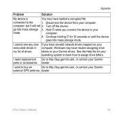
... goes into mass storage 3. dealer. connected to your Garmin drives. Continue holding for your operating system to learn how to assign drive letters. I cannot see any new removable drives in my list of drives. eTrex Owner's Manual 53 Appendix Problem Solution My device is ... while you have several network drives mapped on your Garmin parts or accessories. dealer. Turn off the device. If you connect the device to http://buy .garmin.com, or contact your Garmin external GPS antenna. I want to buy an Go to http://buy .garmin.com, or contact your computer, ...
... goes into mass storage 3. dealer. connected to your Garmin drives. Continue holding for your operating system to learn how to assign drive letters. I cannot see any new removable drives in my list of drives. eTrex Owner's Manual 53 Appendix Problem Solution My device is ... while you have several network drives mapped on your Garmin parts or accessories. dealer. Turn off the device. If you connect the device to http://buy .garmin.com, or contact your Garmin external GPS antenna. I want to buy an Go to http://buy .garmin.com, or contact your computer, ...

Owner's Manual
Page 55
... 30 downloading geocaches 21 software 40 driving routes 37 E editing profiles 30 routes 12 waypoints 9 eTrex Owner's Manual elevation plot 19, 20 barometric altimeter 20 of a track 15 F file types... options 46 G geocaches 21, 35 downloading 21 filter list 21 logging attempt 22 navigating to 22 settings 35 GPS signals 8, 26, 30, 47, 49, 52 turning off 26 H heading settings 34 HomePort 43 Index hunting... times 25 K keys 5, 6 L language 30 locking ring 6 M main menu customizing 28 map 16, 17 additional 11 datum 34 detail 32 information 32 optional 46 restore 39 setup 32 viewing routes ...
... 30 downloading geocaches 21 software 40 driving routes 37 E editing profiles 30 routes 12 waypoints 9 eTrex Owner's Manual elevation plot 19, 20 barometric altimeter 20 of a track 15 F file types... options 46 G geocaches 21, 35 downloading 21 filter list 21 logging attempt 22 navigating to 22 settings 35 GPS signals 8, 26, 30, 47, 49, 52 turning off 26 H heading settings 34 HomePort 43 Index hunting... times 25 K keys 5, 6 L language 30 locking ring 6 M main menu customizing 28 map 16, 17 additional 11 datum 34 detail 32 information 32 optional 46 restore 39 setup 32 viewing routes ...

Owner's Manual
Page 56
...a geocache 22 to waypoints 9 with bearing pointer 18 with course pointer 19 north up 31 O orientation, map 31 P pages 39 adding 39 removing 39 position format 33 power key 8 profiles 29 changing 29 creating 29... signals 8, 26, 47, 49, 52 system settings 30 turning off GPS 26, 27 saving tracks 15 sharing data 24 Sight N' Go 10 software updating 40 version 40 stopwatch 26 storing the device 42 sunrise and... sunset times 25, 50 system settings 30 T text size, maps 32 time alarms 26 data ...
...a geocache 22 to waypoints 9 with bearing pointer 18 with course pointer 19 north up 31 O orientation, map 31 P pages 39 adding 39 removing 39 position format 33 power key 8 profiles 29 changing 29 creating 29... signals 8, 26, 47, 49, 52 system settings 30 turning off GPS 26, 27 saving tracks 15 sharing data 24 Sight N' Go 10 software updating 40 version 40 stopwatch 26 storing the device 42 sunrise and... sunset times 25, 50 system settings 30 T text size, maps 32 time alarms 26 data ...


