

Owner's Manual
Page 1
eTrex® owner's manual for use with models 10, 20, 30
eTrex® owner's manual for use with models 10, 20, 30

Owner's Manual
Page 3
... 11 Routes 12 Tracks 14 Navigation 16 Navigating to a Destination..........16 Map 16 Compass 17 Elevation Plot 19 Trip Computer 20 eTrex Owner's Manual Table of Contents Geocaches 21 Downloading Geocaches 21 Filtering the Geocache List..........21 Navigating to a Geocache............22 Logging...24 Sharing Data 24 Setting a Proximity Alarm 24 Calculating the Size of Contents Getting Started 5 Device Overview 5 Using the eTrex Keys 6 Battery Information 7 Turning the Device On or Off.........8 Satellite Signals 8 Registering Your Device 8 Waypoints, Routes, and Tracks 9 Waypoints ...
... 11 Routes 12 Tracks 14 Navigation 16 Navigating to a Destination..........16 Map 16 Compass 17 Elevation Plot 19 Trip Computer 20 eTrex Owner's Manual Table of Contents Geocaches 21 Downloading Geocaches 21 Filtering the Geocache List..........21 Navigating to a Geocache............22 Logging...24 Sharing Data 24 Setting a Proximity Alarm 24 Calculating the Size of Contents Getting Started 5 Device Overview 5 Using the eTrex Keys 6 Battery Information 7 Turning the Device On or Off.........8 Satellite Signals 8 Registering Your Device 8 Waypoints, Routes, and Tracks 9 Waypoints ...

Owner's Manual
Page 7
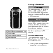
...Batteries The device operates on two AA batteries. Replace the battery cover, and turn the D-ring clockwise. 4. Hold . 5. eTrex Owner's Manual 7 Alkaline batteries can use lithium batteries when operating the device in below-freezing conditions. Therefore, use alkaline, NiMH,...notice Alkaline batteries lose a significant amount of some batteries. Use NiMH or lithium batteries for the device (-4°F to 158°F, or -20 to remove the cover. 3. Insert the batteries, observing polarity. Select Alkaline, Lithium, or Rechargeable NiMH. Battery Information ‹ warning The ...
...Batteries The device operates on two AA batteries. Replace the battery cover, and turn the D-ring clockwise. 4. Hold . 5. eTrex Owner's Manual 7 Alkaline batteries can use lithium batteries when operating the device in below-freezing conditions. Therefore, use alkaline, NiMH,...notice Alkaline batteries lose a significant amount of some batteries. Use NiMH or lithium batteries for the device (-4°F to 158°F, or -20 to remove the cover. 3. Insert the batteries, observing polarity. Select Alkaline, Lithium, or Rechargeable NiMH. Battery Information ‹ warning The ...

Owner's Manual
Page 11
...go to . Menu You can use the Where To? Waypoints, Routes, and Tracks Finding a Location by Name Depending on the maps loaded on the eTrex 20 and eTrex 30, such as BirdsEye™ satellite imagery, BlueChart® g2, TOPO, and City Navigator® detailed maps. menu to find a destination to navigate... of interest, such as restaurants, hotels, and auto services. 1. Enter all Where To? Additional Maps You can use additional maps on your Garmin dealer. categories are available in all areas and maps. Select Where To?. 2. Finding a Location Near Another Location 1. Where To?
...go to . Menu You can use the Where To? Waypoints, Routes, and Tracks Finding a Location by Name Depending on the maps loaded on the eTrex 20 and eTrex 30, such as BirdsEye™ satellite imagery, BlueChart® g2, TOPO, and City Navigator® detailed maps. menu to find a destination to navigate... of interest, such as restaurants, hotels, and auto services. 1. Enter all Where To? Additional Maps You can use additional maps on your Garmin dealer. categories are available in all areas and maps. Select Where To?. 2. Finding a Location Near Another Location 1. Where To?

Owner's Manual
Page 17
...the text bar along the top of the screen shows information about the selected location. Navigation Compass The eTrex 30 has a 3-axis, electronic compass. Use the map to navigate to your vehicle. 1. Follow ...the turns in your destination. Calibrating the Compass Notice Calibrate the electronic compass outdoors. eTrex Owner's Manual 17 Navigating a Driving Route Driving route navigation is using the automotive profile, the compass displays...destination. 3. Select Profile Change > Automotive. 2. • Select a location on the eTrex 20 and eTrex 30.
...the text bar along the top of the screen shows information about the selected location. Navigation Compass The eTrex 30 has a 3-axis, electronic compass. Use the map to navigate to your vehicle. 1. Follow ...the turns in your destination. Calibrating the Compass Notice Calibrate the electronic compass outdoors. eTrex Owner's Manual 17 Navigating a Driving Route Driving route navigation is using the automotive profile, the compass displays...destination. 3. Select Profile Change > Automotive. 2. • Select a location on the eTrex 20 and eTrex 30.

Owner's Manual
Page 20
..., maximum speed, trip odometer, and other helpful statistics. Select Elevation Plot > menu > Calibrate Altimeter. 3. Go to zero. To customize the trip computer, see page 28. 20 eTrex Owner's Manual Resetting the Trip Data For accurate information, reset the trip information before beginning a trip.
..., maximum speed, trip odometer, and other helpful statistics. Select Elevation Plot > menu > Calibrate Altimeter. 3. Go to zero. To customize the trip computer, see page 28. 20 eTrex Owner's Manual Resetting the Trip Data For accurate information, reset the trip information before beginning a trip.

Owner's Manual
Page 24
... 10 feet (3 m) of a particular location. 1. You can share data wirelessly, you can share waypoints, geocaches, routes, and tracks. Select Send or Receive. 3. Select Create Alarm. 3. Sending and Receiving Data Wirelessly Before you must be within a specified range of a compatible Garmin ...device. 1. Setting a Proximity Alarm Proximity alarms alert you when you enter a proximity alarm area, the device sounds a tone (eTrex 20/30). 24 eTrex Owner's Manual Select a location. 5. Select Done. Applications Applications Sharing Data The eTrex 30 can ...
... 10 feet (3 m) of a particular location. 1. You can share data wirelessly, you can share waypoints, geocaches, routes, and tracks. Select Send or Receive. 3. Select Create Alarm. 3. Sending and Receiving Data Wirelessly Before you must be within a specified range of a compatible Garmin ...device. 1. Setting a Proximity Alarm Proximity alarms alert you when you enter a proximity alarm area, the device sounds a tone (eTrex 20/30). 24 eTrex Owner's Manual Select a location. 5. Select Done. Applications Applications Sharing Data The eTrex 30 can ...

Owner's Manual
Page 26
... the device, you can set the time, and select Done. 3. Select the clock numbers to set the device to change the view of that satellite (eTrex 20/30). Select Turn Alarm On. 4. Opening the Stopwatch Select Stopwatch. Turning Off GPS Select Satellite > menu > Use With GPS Off. 26...
... the device, you can set the time, and select Done. 3. Select the clock numbers to set the device to change the view of that satellite (eTrex 20/30). Select Turn Alarm On. 4. Opening the Stopwatch Select Stopwatch. Turning Off GPS Select Satellite > menu > Use With GPS Off. 26...

Owner's Manual
Page 30
... Geostationary Navigation Overlay Service), or Demo Mode (GPS off . System Settings Select Setup > System. • GPS-sets the GPS to http://www.garmin.com/ aboutGPS/waas.html. • Language-sets the text language on the device. Display Settings Select Setup > Display. • Backlight Timeout-adjusts...before the backlight turns off ). Select Done. Select a profile. 3. Note: To adjust the backlight brightness, see page 40. • Colors (eTrex 20/30)-sets the colors that display in Night and Day mode. ◦◦ Mode-sets a light background (Day), a dark background 30...
... Geostationary Navigation Overlay Service), or Demo Mode (GPS off . System Settings Select Setup > System. • GPS-sets the GPS to http://www.garmin.com/ aboutGPS/waas.html. • Language-sets the text language on the device. Display Settings Select Setup > Display. • Backlight Timeout-adjusts...before the backlight turns off ). Select Done. Select a profile. 3. Note: To adjust the backlight brightness, see page 40. • Colors (eTrex 20/30)-sets the colors that display in Night and Day mode. ◦◦ Mode-sets a light background (Day), a dark background 30...

Owner's Manual
Page 33
... select a 12-hour or a 24-hour display time. • Time Zone-allows you are saved and cleared automatically based on your tracks. eTrex Owner's Manual 33 Customizing Your Device Time Settings Select Setup > Time. • Time Format-allows you to set the time zone automatically based... on the user setting. • Color (eTrex 20/30)-changes the color of measure for the setting. Select Setup > Position Format. • Position Format-sets the position format in which a given...
... select a 12-hour or a 24-hour display time. • Time Zone-allows you are saved and cleared automatically based on your tracks. eTrex Owner's Manual 33 Customizing Your Device Time Settings Select Setup > Time. • Time Format-allows you to set the time zone automatically based... on the user setting. • Color (eTrex 20/30)-changes the color of measure for the setting. Select Setup > Position Format. • Position Format-sets the position format in which a given...

Owner's Manual
Page 35
...over a period of time. ◦◦ Ambient Pressure-records ambient pressure changes over a period of time. • Calibrate Altimeter-page 20. • Barometer Mode ◦◦ Variable Elevation-allows the barometer to measure changes in elevation while you are watching for pressure fronts. ... at a fixed elevation. This can be useful when you to weather. • Pressure Trending ◦◦ Save When Power On- eTrex Owner's Manual 35 Geocaching Settings Select Setup > Geocaches. • Geocache List-allows you are moving. ◦◦ Fixed Elevation-assumes ...
...over a period of time. ◦◦ Ambient Pressure-records ambient pressure changes over a period of time. • Calibrate Altimeter-page 20. • Barometer Mode ◦◦ Variable Elevation-allows the barometer to measure changes in elevation while you are watching for pressure fronts. ... at a fixed elevation. This can be useful when you to weather. • Pressure Trending ◦◦ Save When Power On- eTrex Owner's Manual 35 Geocaching Settings Select Setup > Geocaches. • Geocache List-allows you are moving. ◦◦ Fixed Elevation-assumes ...

Owner's Manual
Page 37
...;◦ Nautical-displays various map features in different colors so that the marine POIs are within a specified distance of marine navigation aids on the eTrex 20 and eTrex 30. eTrex Owner's Manual 37 Simplifies map presentation for optimal use while fishing. • Appearance-allows you to set the appearance of your position on the...
...;◦ Nautical-displays various map features in different colors so that the marine POIs are within a specified distance of marine navigation aids on the eTrex 20 and eTrex 30. eTrex Owner's Manual 37 Simplifies map presentation for optimal use while fishing. • Appearance-allows you to set the appearance of your position on the...

Owner's Manual
Page 41
...a significant amount of some batteries. Device Information ‹ caution Contact your local waste disposal department to properly recycle the batteries. eTrex Owner's Manual 41 Do not use lithium batteries when operating the device in below-freezing conditions. Specifications Water resistance Rugged plastic, ...batteries, (alkaline, NiMH, lithium, or precharged NiMH) Battery Life Up to 25 hours Operating From -4°F to 158°F temperature (-20°C to 70°C) range About the Batteries ‹ warning The temperature rating for the device (page 41) may exceed the ...
...a significant amount of some batteries. Device Information ‹ caution Contact your local waste disposal department to properly recycle the batteries. eTrex Owner's Manual 41 Do not use lithium batteries when operating the device in below-freezing conditions. Specifications Water resistance Rugged plastic, ...batteries, (alkaline, NiMH, lithium, or precharged NiMH) Battery Life Up to 25 hours Operating From -4°F to 158°F temperature (-20°C to 70°C) range About the Batteries ‹ warning The temperature rating for the device (page 41) may exceed the ...

Owner's Manual
Page 43
...are available preloaded on memory cards. Turn the D-ring counter-clockwise, and pull up , as instructed in the battery compartment. ➊➋ eTrex Owner's Manual 43 Remove the batteries or battery. 3. Slide the card holder ➊ toward the bottom of the device and lift up to...to http://buy.garmin.com for additional storage. It is not compatible with Mac® OS 10.3 and earlier. Go to http://www.garmin.com. • GPI custom POI files from the Garmin POI Loader • GPX geocache files Device Information Installing a microSD Card The eTrex 20 and eTrex 30 can use...
...are available preloaded on memory cards. Turn the D-ring counter-clockwise, and pull up , as instructed in the battery compartment. ➊➋ eTrex Owner's Manual 43 Remove the batteries or battery. 3. Slide the card holder ➊ toward the bottom of the device and lift up to...to http://buy.garmin.com for additional storage. It is not compatible with Mac® OS 10.3 and earlier. Go to http://www.garmin.com. • GPI custom POI files from the Garmin POI Loader • GPX geocache files Device Information Installing a microSD Card The eTrex 20 and eTrex 30 can use...

Owner's Manual
Page 54
...clock 26 marine 38 proximity 24 tones for 31 almanac hunting and fishing 25 sunrise and sunset 25 altimeter calibrating 20 plot type 35 settings 34 ANT+ accessories 46 area calculation 25 automotive mode 31 auto mounts 17 auto zoom ... 7 storage 7 warnings 7 BirdsEye satellite imagery 11 BlueChart g2 maps 11 54 C calculator 25 calendar 25 calibrating altimeter 20 compass 18 caring for the device 42 long-term storage 42 chirp 23 City Navigator maps 17 compass 17 calibrating 18 ... accessories 46 course pointer 19 creating routes 12 waypoints 9 customizing data fields 28 eTrex Owner's Manual
...clock 26 marine 38 proximity 24 tones for 31 almanac hunting and fishing 25 sunrise and sunset 25 altimeter calibrating 20 plot type 35 settings 34 ANT+ accessories 46 area calculation 25 automotive mode 31 auto mounts 17 auto zoom ... 7 storage 7 warnings 7 BirdsEye satellite imagery 11 BlueChart g2 maps 11 54 C calculator 25 calendar 25 calibrating altimeter 20 compass 18 caring for the device 42 long-term storage 42 chirp 23 City Navigator maps 17 compass 17 calibrating 18 ... accessories 46 course pointer 19 creating routes 12 waypoints 9 customizing data fields 28 eTrex Owner's Manual

Owner's Manual
Page 55
... backlight timeout 30 screen capture 30 settings 30 downloading geocaches 21 software 40 driving routes 37 E editing profiles 30 routes 12 waypoints 9 eTrex Owner's Manual elevation plot 19, 20 barometric altimeter 20 of a track 15 F file types 43 finding addresses 12 near your location 11 fishing times 25 fitness options 46 G geocaches 21...
... backlight timeout 30 screen capture 30 settings 30 downloading geocaches 21 software 40 driving routes 37 E editing profiles 30 routes 12 waypoints 9 eTrex Owner's Manual elevation plot 19, 20 barometric altimeter 20 of a track 15 F file types 43 finding addresses 12 near your location 11 fishing times 25 fitness options 46 G geocaches 21...

Owner's Manual
Page 56
...creating 29 selecting 29 proximity alarms 24 R recording tracks 14, 32 registering your device 8 resetting all settings 52 data 38 device 52 elevation plot 20 restoring default settings 39 routes 12-13 active route 13 avoidance 37 creating 12 deleting 13 editing 13 navigating 13 settings 36 S satellite signals 8, 26..., 47, 49, 52 system settings 30 turning off GPS 26, 27 saving tracks 15 sharing data 24 Sight N' Go 10 software updating 40 version 40 stopwatch 26 storing the device 42 sunrise and sunset times 25, 50 system settings 30 T text size, maps 32 time...
...creating 29 selecting 29 proximity alarms 24 R recording tracks 14, 32 registering your device 8 resetting all settings 52 data 38 device 52 elevation plot 20 restoring default settings 39 routes 12-13 active route 13 avoidance 37 creating 12 deleting 13 editing 13 navigating 13 settings 36 S satellite signals 8, 26..., 47, 49, 52 system settings 30 turning off GPS 26, 27 saving tracks 15 sharing data 24 Sight N' Go 10 software updating 40 version 40 stopwatch 26 storing the device 42 sunrise and sunset times 25, 50 system settings 30 T text size, maps 32 time...
Owner's Manual
Page 57
Index tracks 14-16 archiving 15 clearing current 15 deleting 15 profiles 15 recording 14, 32 saving 15 setup 32 viewing 15 track up 31 transferring files 44 using USB 44 wirelessly 24 trip computer 20 restore 39 troubleshooting 52 W waypoints 9-10 averaging 10 creating 9 deleting 9 editing 9 navigating to 16 WebUpdater 40 Where To? 11 Z zooming 32 U unit ID 40 units of measure 33 updating software 40 USB cable 52 connecting 44 disconnecting 45 eTrex Owner's Manual 57
Index tracks 14-16 archiving 15 clearing current 15 deleting 15 profiles 15 recording 14, 32 saving 15 setup 32 viewing 15 track up 31 transferring files 44 using USB 44 wirelessly 24 trip computer 20 restore 39 troubleshooting 52 W waypoints 9-10 averaging 10 creating 9 deleting 9 editing 9 navigating to 16 WebUpdater 40 Where To? 11 Z zooming 32 U unit ID 40 units of measure 33 updating software 40 USB cable 52 connecting 44 disconnecting 45 eTrex Owner's Manual 57
Quick Start Manual
Page 3
... 158°F, or -20°C to remove the cover. Turn the D-ring counter-clockwise, and pull up to 70°C) may exceed the usable range of their capacity as temperature decreases. Installing AA Batteries You can rupture at high temperatures. The device operates on two AA batteries. eTrex 10 Quick Start Manual 3 Therefore...
... 158°F, or -20°C to remove the cover. Turn the D-ring counter-clockwise, and pull up to 70°C) may exceed the usable range of their capacity as temperature decreases. Installing AA Batteries You can rupture at high temperatures. The device operates on two AA batteries. eTrex 10 Quick Start Manual 3 Therefore...


