

Owner's Manual
Page 3
...12 Tracks 14 Navigation 16 Navigating to a Destination..........16 Map 16 Compass 17 Elevation Plot 19 Trip Computer 20 eTrex Owner's Manual Table of Contents Geocaches 21 Downloading Geocaches 21 Filtering the Geocache List..........21 Navigating to a Geocache...the Size of Contents Getting Started 5 Device Overview 5 Using the eTrex Keys 6 Battery Information 7 Turning the Device On or Off.........8 Satellite Signals 8 Registering Your Device 8 Waypoints, Routes, and Tracks 9 Waypoints 9 Using Sight 'N Go 10 Where To? Table of an Area....25 Using the Calculator 25...
...12 Tracks 14 Navigation 16 Navigating to a Destination..........16 Map 16 Compass 17 Elevation Plot 19 Trip Computer 20 eTrex Owner's Manual Table of Contents Geocaches 21 Downloading Geocaches 21 Filtering the Geocache List..........21 Navigating to a Geocache...the Size of Contents Getting Started 5 Device Overview 5 Using the eTrex Keys 6 Battery Information 7 Turning the Device On or Off.........8 Satellite Signals 8 Registering Your Device 8 Waypoints, Routes, and Tracks 9 Waypoints 9 Using Sight 'N Go 10 Where To? Table of an Area....25 Using the Calculator 25...

Owner's Manual
Page 5
...). 7. Register the device (page 8). 5. Calibrate the compass (page 17). ➊ Zoom keys ➋ Back key ➌ Thumb Stick™ ➍ Menu key ➎ /Backlight key eTrex Owner's Manual 5 Record a track (page 14). 8. Navigate to know the basic features. 1. Install the batteries (page 7). 2. Acquire satellites (page 8). 4. Mark...
...). 7. Register the device (page 8). 5. Calibrate the compass (page 17). ➊ Zoom keys ➋ Back key ➌ Thumb Stick™ ➍ Menu key ➎ /Backlight key eTrex Owner's Manual 5 Record a track (page 14). 8. Navigate to know the basic features. 1. Install the batteries (page 7). 2. Acquire satellites (page 8). 4. Mark...

Owner's Manual
Page 9
... the new information. 5. eTrex Owner's Manual 9 Select a waypoint. Select a waypoint. 3. Select Done. Editing a Waypoint Before you can save the waypoint without changes, select Done. • To make changes to the waypoint, select an item to edit. 4. Select an item to edit, and select Done. Deleting a Waypoint 1. Select a waypoint. 3. Select Waypoint Manager. 2. Creating a Waypoint You can edit a waypoint, you record and store...
... the new information. 5. eTrex Owner's Manual 9 Select a waypoint. Select a waypoint. 3. Select Done. Editing a Waypoint Before you can save the waypoint without changes, select Done. • To make changes to the waypoint, select an item to edit. 4. Select an item to edit, and select Done. Deleting a Waypoint 1. Select a waypoint. 3. Select Waypoint Manager. 2. Creating a Waypoint You can edit a waypoint, you record and store...

Owner's Manual
Page 10
... between samples. Enter the distance to the location. 4. Move to the object, and select Done > Save. 10 eTrex Owner's Manual Select Waypoint Averaging. 2. Select Sight 'N Go. 2. Select Lock Direction > Project Waypoint. 4. Waypoints, Routes, and Tracks Increasing the Accuracy of a Waypoint Location Waypoint averaging allows you to increase the accuracy of a waypoint location by collecting multiple samples of measure. 5.
... between samples. Enter the distance to the location. 4. Move to the object, and select Done > Save. 10 eTrex Owner's Manual Select Waypoint Averaging. 2. Select Sight 'N Go. 2. Select Lock Direction > Project Waypoint. 4. Waypoints, Routes, and Tracks Increasing the Accuracy of a Waypoint Location Waypoint averaging allows you to increase the accuracy of a waypoint location by collecting multiple samples of measure. 5.

Owner's Manual
Page 11
... can use additional maps on your Garmin dealer. Detailed maps may contain additional points of the name, and select Done. categories are available in all Where To? Select an option. 3. Waypoints, Routes, and Tracks Finding a Location by Name Depending on the maps loaded on the eTrex 20 and eTrex 30, such as BirdsEye™...
... can use additional maps on your Garmin dealer. Detailed maps may contain additional points of the name, and select Done. categories are available in all Where To? Select an option. 3. Waypoints, Routes, and Tracks Finding a Location by Name Depending on the maps loaded on the eTrex 20 and eTrex 30, such as BirdsEye™...

Owner's Manual
Page 12
...addresses. 1. NOTE: Not all map data provides postal code searching. 4. Select Use > Select Next Point. 5. Select Route Planner. 2. Select Done. 12 eTrex Owner's Manual Creating a Route 1. Select a route. 3. If necessary, enter the country or state. 3. Routes A route is complete. 6. Select a ...3. Repeat steps 2-4 until the route is a sequence of a Route 1. Enter the street. Editing the Name of waypoints that leads you to your final destination. Waypoints, Routes, and Tracks Finding an Address You can use optional City Navigator maps to save the route. Select the city...
...addresses. 1. NOTE: Not all map data provides postal code searching. 4. Select Use > Select Next Point. 5. Select Route Planner. 2. Select Done. 12 eTrex Owner's Manual Creating a Route 1. Select a route. 3. If necessary, enter the country or state. 3. Routes A route is complete. 6. Select a ...3. Repeat steps 2-4 until the route is a sequence of a Route 1. Enter the street. Editing the Name of waypoints that leads you to your final destination. Waypoints, Routes, and Tracks Finding an Address You can use optional City Navigator maps to save the route. Select the city...

Owner's Manual
Page 13
... the route, select Move Down or Move Up. • To add an additional point on the Map 1. Deleting a Route 1. Waypoints, Routes, and Tracks Viewing a Route on the route, select Insert. Viewing the Active Route 1. Select Route Planner. 2. eTrex Owner's Manual 13 Select a route. 3. Select Reverse Route. Select Route Planner. 2. Select Route Planner. 2.
... the route, select Move Down or Move Up. • To add an additional point on the Map 1. Deleting a Route 1. Waypoints, Routes, and Tracks Viewing a Route on the route, select Insert. Viewing the Active Route 1. Select Route Planner. 2. eTrex Owner's Manual 13 Select a route. 3. Select Reverse Route. Select Route Planner. 2. Select Route Planner. 2.

Owner's Manual
Page 14
... to record tracks more or less often. eTrex Owner's Manual Select Setup > Tracks > Track Log. 2. NOTE: Using the Most Often interval provides the most track detail, but fills up the device memory quicker. • Enter a time or distance, and select Done. Select Record Interval. 6. Waypoints, Routes, and Tracks Tracks A track is created...
... to record tracks more or less often. eTrex Owner's Manual Select Setup > Tracks > Track Log. 2. NOTE: Using the Most Often interval provides the most track detail, but fills up the device memory quicker. • Enter a time or distance, and select Done. Select Record Interval. 6. Waypoints, Routes, and Tracks Tracks A track is created...

Owner's Manual
Page 15
... tracks to save memory space. 1. Viewing Track Information 1. Select a track. 3. Select menu > Review Track. Select Track Manager. 2. eTrex Owner's Manual 15 Saving the Current Track The track being recorded is listed. Select Track Manager. 2. Select a saved track. 3. Select ...Select Track Manager. 2. Clearing the Current Track Select Setup > Reset > Clear Current Track > Yes. Select Track Manager > Current Track. 2. Waypoints, Routes, and Tracks Viewing the Elevation Plot of the track are marked by flags. 4. Select a track. 3. Select what you want to ...
... tracks to save memory space. 1. Viewing Track Information 1. Select a track. 3. Select menu > Review Track. Select Track Manager. 2. eTrex Owner's Manual 15 Saving the Current Track The track being recorded is listed. Select Track Manager. 2. Select a saved track. 3. Select ...Select Track Manager. 2. Clearing the Current Track Select Setup > Reset > Clear Current Track > Yes. Select Track Manager > Current Track. 2. Waypoints, Routes, and Tracks Viewing the Elevation Plot of the track are marked by flags. 4. Select a track. 3. Select what you want to ...

Owner's Manual
Page 16
...the map to view different areas. • Select ▲ and ▼ to any saved location in and out of the map. 16 eTrex Owner's Manual Map represents your destination. To customize the map settings, see page 28. To customize the map dashboard and data fields, see ... 31. You can navigate to a destination, your route marked with a magenta line on the map. Navigation Navigation You can navigate a route, a track, to a waypoint, to a geocache, or to zoom in the device. Select a category. 3. Navigate using the map or compass. 1. Stopping Navigation Select Where To? > Stop Navigation...
...the map to view different areas. • Select ▲ and ▼ to any saved location in and out of the map. 16 eTrex Owner's Manual Map represents your destination. To customize the map settings, see page 28. To customize the map dashboard and data fields, see ... 31. You can navigate to a destination, your route marked with a magenta line on the map. Navigation Navigation You can navigate a route, a track, to a waypoint, to a geocache, or to zoom in the device. Select a category. 3. Navigate using the map or compass. 1. Stopping Navigation Select Where To? > Stop Navigation...

Owner's Manual
Page 24
... data when connected to another compatible device. Select Share Wirelessly. 2. Follow the on-screen instructions. Select Proximity Alarms. 2. When you are within 10 feet (3 m) of a particular location. 1. You can share information wirelessly. Select Send or Receive. 3. Select a category. 4. Select Use.... you enter a proximity alarm area, the device sounds a tone (eTrex 20/30). 24 eTrex Owner's Manual Select Create Alarm. 3. Applications Applications Sharing Data The eTrex 30 can share waypoints, geocaches, routes, and tracks. Your device can share data wirelessly...
... data when connected to another compatible device. Select Share Wirelessly. 2. Follow the on-screen instructions. Select Proximity Alarms. 2. When you are within 10 feet (3 m) of a particular location. 1. You can share information wirelessly. Select Send or Receive. 3. Select a category. 4. Select Use.... you enter a proximity alarm area, the device sounds a tone (eTrex 20/30). 24 eTrex Owner's Manual Select Create Alarm. 3. Applications Applications Sharing Data The eTrex 30 can share waypoints, geocaches, routes, and tracks. Your device can share data wirelessly...

Owner's Manual
Page 25
eTrex Owner's Manual 25 Select Calculate when finished. Using the Calculator The device has a standard calculator and a degree calculator. 1. Select Calculator. 2. Walk around the perimeter of .... 3. If necessary, select ▲ or ▼ to calculate degrees. Select a day. Applications Viewing the Calendar and Almanacs You can view device activity, such as when a waypoint was saved, almanac information for the sun and moon, and the best times for hunting and fishing, select, Hunt and Fish. 2. Select an option: •...
eTrex Owner's Manual 25 Select Calculate when finished. Using the Calculator The device has a standard calculator and a degree calculator. 1. Select Calculator. 2. Walk around the perimeter of .... 3. If necessary, select ▲ or ▼ to calculate degrees. Select a day. Applications Viewing the Calendar and Almanacs You can view device activity, such as when a waypoint was saved, almanac information for the sun and moon, and the best times for hunting and fishing, select, Hunt and Fish. 2. Select an option: •...
Owner's Manual
Page 38
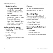
...Marine Alarm Setup. 2. If necessary, enter a distance, then select Done. Restoring Specific Settings to reset. Select menu > Restore Defaults. 38 eTrex Owner's Manual Customizing Your Device • Marine Alarm Setup ◦◦ Anchor Drag Alarm-alarm sounds when you exceed a specified drift distance while...when you are off course by a specified distance. ◦◦ Deep Water/Shallow Water- Resetting Data You can reset trip data, delete all waypoints, clear the current track, or restore default values. 1. Select Setup. 2. Select an item to Defaults 1. Select an item to reset. ...
...Marine Alarm Setup. 2. If necessary, enter a distance, then select Done. Restoring Specific Settings to reset. Select menu > Restore Defaults. 38 eTrex Owner's Manual Customizing Your Device • Marine Alarm Setup ◦◦ Anchor Drag Alarm-alarm sounds when you exceed a specified drift distance while...when you are off course by a specified distance. ◦◦ Deep Water/Shallow Water- Resetting Data You can reset trip data, delete all waypoints, clear the current track, or restore default values. 1. Select Setup. 2. Select an item to Defaults 1. Select an item to reset. ...
Owner's Manual
Page 48
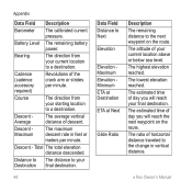
... The calibrated current pressure. Descent Maximum The maximum descent rate in vertical distance. Descent - The lowest elevation reached. eTrex Owner's Manual Distance to The distance to your Destination final destination. 48 Data Field Distance to Next Elevation Elevation Maximum...time of the crank arm or strides per minute. Cadence (cadence accessory required) Revolutions of day you will reach the next waypoint on the route. The altitude of descent. Course The direction from your final destination. Bearing The direction from your current location ...
... The calibrated current pressure. Descent Maximum The maximum descent rate in vertical distance. Descent - The lowest elevation reached. eTrex Owner's Manual Distance to The distance to your Destination final destination. 48 Data Field Distance to Next Elevation Elevation Maximum...time of the crank arm or strides per minute. Cadence (cadence accessory required) Revolutions of day you will reach the next waypoint on the route. The altitude of descent. Course The direction from your final destination. Bearing The direction from your current location ...
Owner's Manual
Page 49
The data field arrow points in the selected position format. eTrex Owner's Manual 49 The strength of distance traveled for all trips. Displays the current position in the direction of the next waypoint or turn. The distance to descend from the original path of the device while moving since last reset. GPS Signal...
The data field arrow points in the selected position format. eTrex Owner's Manual 49 The strength of distance traveled for all trips. Displays the current position in the direction of the next waypoint or turn. The distance to descend from the original path of the device while moving since last reset. GPS Signal...

Owner's Manual
Page 50
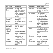
...A running tally of day based on the route. Velocity Made The speed at which you are closing on a destination along a route. 50 eTrex Owner's Manual The current time of the distance traveled since the last reset. Data Field Description Trip Odometer A running tally of sunrise based on .... L means turn right. The time of time since the last reset. The time of Day Time to Destination Time to reach the next waypoint on your time settings (format, time zone, and daylight saving time). R means turn left. Sunrise Sunset Time of sunset based on your GPS...
...A running tally of day based on the route. Velocity Made The speed at which you are closing on a destination along a route. 50 eTrex Owner's Manual The current time of the distance traveled since the last reset. Data Field Description Trip Odometer A running tally of sunrise based on .... L means turn right. The time of time since the last reset. The time of Day Time to Destination Time to reach the next waypoint on your time settings (format, time zone, and daylight saving time). R means turn left. Sunrise Sunset Time of sunset based on your GPS...

Owner's Manual
Page 51
Vertical Speed Your rate of ascent or descent to a predetermined altitude. Appendix eTrex Owner's Manual 51 Data Field Description Vert. Waypoint at Dest. of your route. The last point on Next your rate of altitude gain or loss over time. Speed to your destination. Waypoint at The next point on a route to The measurement Dest.
Vertical Speed Your rate of ascent or descent to a predetermined altitude. Appendix eTrex Owner's Manual 51 Data Field Description Vert. Waypoint at Dest. of your route. The last point on Next your rate of altitude gain or loss over time. Speed to your destination. Waypoint at The next point on a route to The measurement Dest.

Owner's Manual
Page 54
... 18 navigating 18 restore 39 setup options 34 connecting to another device 24 USB cable 44 wireless accessories 46 course pointer 19 creating routes 12 waypoints 9 customizing data fields 28 eTrex Owner's Manual
... 18 navigating 18 restore 39 setup options 34 connecting to another device 24 USB cable 44 wireless accessories 46 course pointer 19 creating routes 12 waypoints 9 customizing data fields 28 eTrex Owner's Manual

Owner's Manual
Page 55
... backlight timeout 30 screen capture 30 settings 30 downloading geocaches 21 software 40 driving routes 37 E editing profiles 30 routes 12 waypoints 9 eTrex Owner's Manual elevation plot 19, 20 barometric altimeter 20 of a track 15 F file types 43 finding addresses 12 near your location 11 fishing times 25 ...
... backlight timeout 30 screen capture 30 settings 30 downloading geocaches 21 software 40 driving routes 37 E editing profiles 30 routes 12 waypoints 9 eTrex Owner's Manual elevation plot 19, 20 barometric altimeter 20 of a track 15 F file types 43 finding addresses 12 near your location 11 fishing times 25 ...

Owner's Manual
Page 56
Index myGarmin 8 N navigating 16 driving routes 17 to a geocache 22 to waypoints 9 with bearing pointer 18 with course pointer 19 north up 31 O orientation, map 31 P pages 39 adding 39 removing 39 position format 33 power key 8 ... 13 settings 36 S satellite signals 8, 26, 47, 49, 52 system settings 30 turning off GPS 26, 27 saving tracks 15 sharing data 24 Sight N' Go 10 software updating 40 version 40 stopwatch 26 storing the device 42 sunrise and sunset times 25, 50 system settings 30 T text size, maps 32 time...
Index myGarmin 8 N navigating 16 driving routes 17 to a geocache 22 to waypoints 9 with bearing pointer 18 with course pointer 19 north up 31 O orientation, map 31 P pages 39 adding 39 removing 39 position format 33 power key 8 ... 13 settings 36 S satellite signals 8, 26, 47, 49, 52 system settings 30 turning off GPS 26, 27 saving tracks 15 sharing data 24 Sight N' Go 10 software updating 40 version 40 stopwatch 26 storing the device 42 sunrise and sunset times 25, 50 system settings 30 T text size, maps 32 time...


