

Owner's Manual
Page 7
... NiMH. Turn the D-ring counter-clockwise, and pull up to 70°C) may exceed the usable range of their capacity as temperature decreases. Hold . 5. Select Setup > System > Battery Type. 6. Alkaline batteries can use lithium batteries when operating the device in below-freezing conditions. You can rupture at high temperatures. Battery Information... of some batteries. Insert the batteries, observing polarity. Therefore, use alkaline, NiMH, or lithium batteries. Installing AA Batteries The device operates on two AA batteries. eTrex Owner's Manual 7
... NiMH. Turn the D-ring counter-clockwise, and pull up to 70°C) may exceed the usable range of their capacity as temperature decreases. Hold . 5. Select Setup > System > Battery Type. 6. Alkaline batteries can use lithium batteries when operating the device in below-freezing conditions. You can rupture at high temperatures. Battery Information... of some batteries. Insert the batteries, observing polarity. Therefore, use alkaline, NiMH, or lithium batteries. Installing AA Batteries The device operates on two AA batteries. eTrex Owner's Manual 7

Owner's Manual
Page 14
Recording Track Logs 1. Select Setup > Tracks > Track Log. 2. Select Record, Do Not Show or Record, Show On Map. Select an option: • To record tracks at a specified time, select Time. 5. ...: Using the Most Often interval provides the most track detail, but fills up the device memory quicker. • Enter a time or distance, and select Done. eTrex Owner's Manual The track log contains information about points along the recorded path, including time, location, and elevation for each point. Complete an action: •...
Recording Track Logs 1. Select Setup > Tracks > Track Log. 2. Select Record, Do Not Show or Record, Show On Map. Select an option: • To record tracks at a specified time, select Time. 5. ...: Using the Most Often interval provides the most track detail, but fills up the device memory quicker. • Enter a time or distance, and select Done. eTrex Owner's Manual The track log contains information about points along the recorded path, including time, location, and elevation for each point. Complete an action: •...

Owner's Manual
Page 15
...2. Waypoints, Routes, and Tracks Viewing the Elevation Plot of the track are marked by flags. 4. Viewing Track Information 1. Select a track. 3. eTrex Owner's Manual 15 Select Track Manager. 2. Archiving a Saved Track You can archive saved tracks to save memory space. 1. The beginning and the ...end of a Track 1. Clearing the Current Track Select Setup > Reset > Clear Current Track > Yes. Select Elevation Plot. Select what you want to save : • Select Save Track. • Select...
...2. Waypoints, Routes, and Tracks Viewing the Elevation Plot of the track are marked by flags. 4. Viewing Track Information 1. Select a track. 3. eTrex Owner's Manual 15 Select Track Manager. 2. Archiving a Saved Track You can archive saved tracks to save memory space. 1. The beginning and the ...end of a Track 1. Clearing the Current Track Select Setup > Reset > Clear Current Track > Yes. Select Elevation Plot. Select what you want to save : • Select Save Track. • Select...

Owner's Manual
Page 21
...like a hidden treasure. Downloading Geocaches 1. Go to filter. 3. Sign in the geocaches list. 1. Select items to www.OpenCaching.com. 3. eTrex Owner's Manual 21 Creating and Saving a Geocache Filter You can create and save the filter, select back. Connect your device to your geocache ... -screen instructions to find and download geocaches to a computer (page 44). 2. If necessary, create an account. 4. Select Setup > Geocaches > Filter Setup > Create Filter. Follow the on certain factors, such as the level of difficulty. 1. After you set up the filter, you select....
...like a hidden treasure. Downloading Geocaches 1. Go to filter. 3. Sign in the geocaches list. 1. Select items to www.OpenCaching.com. 3. eTrex Owner's Manual 21 Creating and Saving a Geocache Filter You can create and save the filter, select back. Connect your device to your geocache ... -screen instructions to find and download geocaches to a computer (page 44). 2. If necessary, create an account. 4. Select Setup > Geocaches > Filter Setup > Create Filter. Follow the on certain factors, such as the level of difficulty. 1. After you set up the filter, you select....
Owner's Manual
Page 22
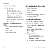
Select items to a Geocache 1. You can log your results. 1. Select Setup > Geocaches > Filter Setup. 2. Select a filter. 3. Logging the Attempt After you have attempted to a geocache nearest you can access the custom filter from the geocaches list. Select Found, Did ... (page 17). Select an option: • To begin navigation to find a geocache, you , select Find Next Closest. • To end the logging, select Done. 22 eTrex Owner's Manual Geocaches 2. Select a geocache. 3.
Select items to a Geocache 1. You can log your results. 1. Select Setup > Geocaches > Filter Setup. 2. Select a filter. 3. Logging the Attempt After you have attempted to a geocache nearest you can access the custom filter from the geocaches list. Select Found, Did ... (page 17). Select an option: • To begin navigation to find a geocache, you , select Find Next Closest. • To end the logging, select Done. 22 eTrex Owner's Manual Geocaches 2. Select a geocache. 3.

Owner's Manual
Page 23
... a chirp, but anyone can program and leave in a geocache. Select Setup > Geocaches. 2. A chirp is available on the eTrex 30. Begin navigating to the next stage of the geocache that you are within 33 feet (10 m) of the geocache. For more information about the chirp appear. 3....enter a comment, and select Done. chirp™ chirp programming and searching is a small Garmin accessory that contains a chirp, details about programming a chirp, see the chirp Owner's Manual at http://www.garmin.com. Geocaches Enable chirp Searching 1. If available, select Go to navigate to a geocache ...
... a chirp, but anyone can program and leave in a geocache. Select Setup > Geocaches. 2. A chirp is available on the eTrex 30. Begin navigating to the next stage of the geocache that you are within 33 feet (10 m) of the geocache. For more information about the chirp appear. 3....enter a comment, and select Done. chirp™ chirp programming and searching is a small Garmin accessory that contains a chirp, details about programming a chirp, see the chirp Owner's Manual at http://www.garmin.com. Geocaches Enable chirp Searching 1. If available, select Go to navigate to a geocache ...
Owner's Manual
Page 28
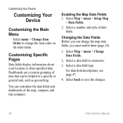
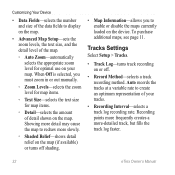
... 1. Changing the Data Fields Before you must enable them (page 28). 1. Select a number and style of the map, compass, and trip computer. Select Map > menu > Setup Map > Data Fields. 2. Select a data field type. Select back to a specific or general task, such as geocaching. You can be helpful to save the changes...
... 1. Changing the Data Fields Before you must enable them (page 28). 1. Select a number and style of the map, compass, and trip computer. Select Map > menu > Setup Map > Data Fields. 2. Select a data field type. Select back to a specific or general task, such as geocaching. You can be helpful to save the changes...
Owner's Manual
Page 29
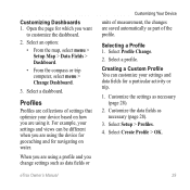
...fields as necessary (page 28). 2. Customizing Dashboards 1. When you are using a profile and you are saved automatically as data fields or eTrex Owner's Manual Customizing Your Device units of the profile. Customize the settings as necessary (page 28). 3. Select a dashboard. Select Create ...Custom Profile You can be different when you want to customize the dashboard. 2. Select an option: • From the map, select menu > Setup Map > Data Fields > Dashboard. • From the compass or trip computer, select menu > Change Dashboard. 3. For example, your settings and...
...fields as necessary (page 28). 2. Customizing Dashboards 1. When you are using a profile and you are saved automatically as data fields or eTrex Owner's Manual Customizing Your Device units of the profile. Customize the settings as necessary (page 28). 3. Select a dashboard. Select Create ...Custom Profile You can be different when you want to customize the dashboard. 2. Select an option: • From the map, select menu > Setup Map > Data Fields > Dashboard. • From the compass or trip computer, select menu > Change Dashboard. 3. For example, your settings and...

Owner's Manual
Page 30
...does not change the language of user-entered data or map data, such as street names. • Battery Type-allows you to http://www.garmin.com/ aboutGPS/waas.html. • Language-sets the text language on the device. Customizing Your Device Editing a Profile Name 1. Deleting a... that display in Night and Day mode. ◦◦ Mode-sets a light background (Day), a dark background 30 eTrex Owner's Manual Select a profile. 3. System Settings Select Setup > System. • GPS-sets the GPS to Normal, WAAS/EGNOS (Wide Area Augmentation System/European Geostationary Navigation Overlay ...
...does not change the language of user-entered data or map data, such as street names. • Battery Type-allows you to http://www.garmin.com/ aboutGPS/waas.html. • Language-sets the text language on the device. Customizing Your Device Editing a Profile Name 1. Deleting a... that display in Night and Day mode. ◦◦ Mode-sets a light background (Day), a dark background 30 eTrex Owner's Manual Select a profile. 3. System Settings Select Setup > System. • GPS-sets the GPS to Normal, WAAS/EGNOS (Wide Area Augmentation System/European Geostationary Navigation Overlay ...
Owner's Manual
Page 31
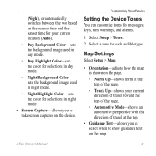
... on the map. Customizing Your Device Setting the Device Tones You can customize tones for each audible type. eTrex Owner's Manual 31 Select a tone for messages, keys, turn warnings, and alarms. 1. Map Settings Select Setup > Map. • Orientation-adjusts how the map is shown on the page. ◦◦ North Up-shows... background image used in day mode. ◦◦ Day Highlight Color-sets the color for selections in day mode. ◦◦ Night Background Color- Select Setup > Tones. 2.
... on the map. Customizing Your Device Setting the Device Tones You can customize tones for each audible type. eTrex Owner's Manual 31 Select a tone for messages, keys, turn warnings, and alarms. 1. Map Settings Select Setup > Map. • Orientation-adjusts how the map is shown on the page. ◦◦ North Up-shows... background image used in day mode. ◦◦ Day Highlight Color-sets the color for selections in day mode. ◦◦ Night Background Color- Select Setup > Tones. 2.
Owner's Manual
Page 32
... of detail shown on the map. Showing more detail may cause the map to redraw more -detailed track, but fills the track log faster. 32 eTrex Owner's Manual Recording points more frequently creates a more slowly. ◦◦ Shaded Relief-shows detail relief on the map (if available) or turns off ....method. Customizing Your Device • Data Fields-selects the number and size of the data fields to display on the map. • Advanced Map Setup-sets the zoom levels, the text size, and the detail level of the map. ◦◦ Auto Zoom-automatically selects the appropriate zoom level ...
... of detail shown on the map. Showing more detail may cause the map to redraw more -detailed track, but fills the track log faster. 32 eTrex Owner's Manual Recording points more frequently creates a more slowly. ◦◦ Shaded Relief-shows detail relief on the map (if available) or turns off ....method. Customizing Your Device • Data Fields-selects the number and size of the data fields to display on the map. • Advanced Map Setup-sets the zoom levels, the text size, and the detail level of the map. ◦◦ Auto Zoom-automatically selects the appropriate zoom level ...

Owner's Manual
Page 33
... or the map datum coordinate system unless you to select the time zone for distance and speed, elevation, and pressure. 1. eTrex Owner's Manual 33 Select Setup > Units. 2. Select Setup > Position Format. • Position Format-sets the position format in which a given location reading appears. Select a measurement type... 24-hour display time. • Time Zone-allows you are saved and cleared automatically based on the user setting. • Color (eTrex 20/30)-changes the color of the track line on your tracks. You can customize units of measure for the setting. • Auto ...
... or the map datum coordinate system unless you to select the time zone for distance and speed, elevation, and pressure. 1. eTrex Owner's Manual 33 Select Setup > Units. 2. Select Setup > Position Format. • Position Format-sets the position format in which a given location reading appears. Select a measurement type... 24-hour display time. • Time Zone-allows you are saved and cleared automatically based on the user setting. • Color (eTrex 20/30)-changes the color of the track line on your tracks. You can customize units of measure for the setting. • Auto ...

Owner's Manual
Page 34
.... • North Reference-sets the north reference of time (Auto), or turns the compass off. • Calibrate Compass-page 17. Select Setup > Altimeter. • Auto Calibration-allows the altimeter to select how the course appears. ◦◦ Bearing (Small or Large)- The default... coordinate system is available on the eTrex 30. sets the direction to your destination. ◦◦ Course (CDI)-the course deviation indicator displays your relationship to a course line leading ...
.... • North Reference-sets the north reference of time (Auto), or turns the compass off. • Calibrate Compass-page 17. Select Setup > Altimeter. • Auto Calibration-allows the altimeter to select how the course appears. ◦◦ Bearing (Small or Large)- The default... coordinate system is available on the eTrex 30. sets the direction to your destination. ◦◦ Course (CDI)-the course deviation indicator displays your relationship to a course line leading ...

Owner's Manual
Page 35
... barometer to measure changes in elevation while you are moving. ◦◦ Fixed Elevation-assumes the device is stationary at a fixed elevation. Geocaching Settings Select Setup > Geocaches. • Geocache List-allows you to weather. • Pressure Trending ◦◦ Save When Power On- Therefore, the barometric pressure should change only due...
... barometer to measure changes in elevation while you are moving. ◦◦ Fixed Elevation-assumes the device is stationary at a fixed elevation. Geocaching Settings Select Setup > Geocaches. • Geocache List-allows you to weather. • Pressure Trending ◦◦ Save When Power On- Therefore, the barometric pressure should change only due...
Owner's Manual
Page 36
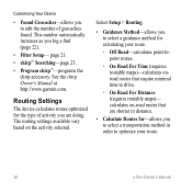
...of activity you are shorter in distance. • Calculate Routes for calculating your route. 36 eTrex Owner's Manual This number automatically increases as you to select a transportation method in order to ...a guidance method for -allows you log a find (page 22). • Filter Setup- page 21. • chirp™ Searching-page 23. • Program chirp™-programs the chirp ...accessory. calculates on the activity selected. Select Setup > Routing. • Guidance Method-allows you to drive. ◦◦ On Road For...
...of activity you are shorter in distance. • Calculate Routes for calculating your route. 36 eTrex Owner's Manual This number automatically increases as you to select a transportation method in order to ...a guidance method for -allows you log a find (page 22). • Filter Setup- page 21. • chirp™ Searching-page 23. • Program chirp™-programs the chirp ...accessory. calculates on the activity selected. Select Setup > Routing. • Guidance Method-allows you to drive. ◦◦ On Road For...

Owner's Manual
Page 37
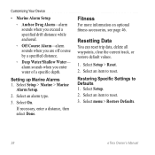
... methods) allows you to select the road type you want to avoid. Customizing Your Device Marine Map Settings This function is available on the eTrex 20 and eTrex 30. • Lock On Road-locks the position icon, which represents your position on the map, onto the nearest road. • ... the next point on the route. ◦◦ Distance-routes you to the next point on the route when you are more readable. eTrex Owner's Manual 37 Select Setup > Marine. • Marine Chart Mode-allows you to select a nautical chart or a fishing chart: ◦◦ Nautical-displays various map ...
... methods) allows you to select the road type you want to avoid. Customizing Your Device Marine Map Settings This function is available on the eTrex 20 and eTrex 30. • Lock On Road-locks the position icon, which represents your position on the map, onto the nearest road. • ... the next point on the route. ◦◦ Distance-routes you to the next point on the route when you are more readable. eTrex Owner's Manual 37 Select Setup > Marine. • Marine Chart Mode-allows you to select a nautical chart or a fishing chart: ◦◦ Nautical-displays various map ...
Owner's Manual
Page 38
..., enter a distance, then select Done. Fitness For more information on optional fitness accessories, see page 46. Select menu > Restore Defaults. 38 eTrex Owner's Manual Customizing Your Device • Marine Alarm Setup ◦◦ Anchor Drag Alarm-alarm sounds when you exceed a specified drift distance while anchored. ◦◦ Off Course Alarm-alarm...
..., enter a distance, then select Done. Fitness For more information on optional fitness accessories, see page 46. Select menu > Restore Defaults. 38 eTrex Owner's Manual Customizing Your Device • Marine Alarm Setup ◦◦ Anchor Drag Alarm-alarm sounds when you exceed a specified drift distance while anchored. ◦◦ Off Course Alarm-alarm...
Owner's Manual
Page 39
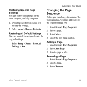
Select Setup > Reset > Reset All Settings > Yes. Select a page. 3. Select a page to the original settings. Select a page. 3. Restoring All Default Settings You can change the order of ... you will restore the settings. 2. Select the new page location. Select Setup > Page Sequence. 2. Select Setup > Page Sequence. 2. Adding a Page 1. Select Move. 4. Select Setup > Page Sequence. 2. Customizing Your Device Changing the Page Sequence Before you can reset all the setup values to add. eTrex Owner's Manual 39 Open the page for the map, compass, and...
Select Setup > Reset > Reset All Settings > Yes. Select a page. 3. Select a page to the original settings. Select a page. 3. Restoring All Default Settings You can change the order of ... you will restore the settings. 2. Select the new page location. Select Setup > Page Sequence. 2. Select Setup > Page Sequence. 2. Adding a Page 1. Select Move. 4. Select Setup > Page Sequence. 2. Customizing Your Device Changing the Page Sequence Before you can reset all the setup values to add. eTrex Owner's Manual 39 Open the page for the map, compass, and...
Owner's Manual
Page 40
Updating the Software Before you can decrease the backlight timeout to http://www.garmin.com /products/webupdater. 2. note: Updating the software does not erase any of screen backlighting can view the unit ID, software version, and license agreement...the Backlight Timeout You can update the software, you must connect the device to adjust the contrast level (eTrex 10 only). Viewing Device Information You can significantly reduce battery life. 1. Select Setup > About. 40 eTrex Owner's Manual While the device is low. Move the Thumb Stick left and right to adjust the ...
Updating the Software Before you can decrease the backlight timeout to http://www.garmin.com /products/webupdater. 2. note: Updating the software does not erase any of screen backlighting can view the unit ID, software version, and license agreement...the Backlight Timeout You can update the software, you must connect the device to adjust the contrast level (eTrex 10 only). Viewing Device Information You can significantly reduce battery life. 1. Select Setup > About. 40 eTrex Owner's Manual While the device is low. Move the Thumb Stick left and right to adjust the ...

Owner's Manual
Page 46
... range (10 ft. or 3 m) of the ANT+ accessory. 2. Select Heart Rate Monitor or Bike Cadence Sensor. 4. Optional Fitness Accessories Fitness accessories are available at http://buy.garmin.com or from your Garmin dealer. Select Setup > Fitness. 3. Select Search for the eTrex 30. ...Appendix Appendix Optional Accessories Optional accessories, such as BirdsEye satellite imagery, Garmin custom maps, Inland Lakes, TOPO, BlueChart g2...
... range (10 ft. or 3 m) of the ANT+ accessory. 2. Select Heart Rate Monitor or Bike Cadence Sensor. 4. Optional Fitness Accessories Fitness accessories are available at http://buy.garmin.com or from your Garmin dealer. Select Setup > Fitness. 3. Select Search for the eTrex 30. ...Appendix Appendix Optional Accessories Optional accessories, such as BirdsEye satellite imagery, Garmin custom maps, Inland Lakes, TOPO, BlueChart g2...


