
Garmin eTrex 10 Support Question
Garmin eTrex 10 Support Question
Find answers below for this question about Garmin eTrex 10.Need a Garmin eTrex 10 manual? We have 2 online manuals for this item!
Question posted by rrammpte on July 17th, 2014
How Clear Route Gps Garmin Etrex 10
The person who posted this question about this Garmin product did not include a detailed explanation. Please use the "Request More Information" button to the right if more details would help you to answer this question.
Current Answers
Related Garmin eTrex 10 Manual Pages
Owner's Manual - Page 3

...30 Display Settings 30
3 Menu 11 Routes 12 Tracks 14
Navigation 16 Navigating to a Destination..........16 Map 16 Compass 17 Elevation Plot 19 Trip Computer 20
eTrex Owner's Manual
Table of Contents
Geocaches...
Getting Started 5 Device Overview 5 Using the eTrex Keys 6 Battery Information 7 Turning the Device On or Off.........8 Satellite Signals 8 Registering Your Device 8
Waypoints...
Owner's Manual - Page 8

...more information about GPS, go to http://my.garmin.com. • Keep the original sales receipt, or a
photocopy, in a safe place.
8
eTrex Owner's Manual...garmin.com/aboutGPS. When the GPS bars on the backlight page (page 40) are set automatically based on , it begins acquiring satellite signals.
Satellite Signals
After the device is turned on the GPS position. The device may need a clear...
Owner's Manual - Page 10

... in the direction, and then navigate to the location.
4. Select a unit of the waypoint location.
1. Waypoints, Routes, and Tracks
Increasing the Accuracy of a Waypoint Location Waypoint averaging allows you to the object, and select Done > Save.
10
eTrex Owner's Manual Select Start.
5. Select Sight 'N Go.
2. Select Lock Direction > Project Waypoint.
4. Enter the distance...
Owner's Manual - Page 11

...Routes, and Tracks
Finding a Location by Name Depending on the maps loaded on the eTrex 20 and eTrex 30, such as restaurants or marine services. Enter all or part of interest (POIs), such as restaurants, hotels, and auto services.
1. Select an option.
3.
Additional Maps You can use additional maps on your Garmin... navigate to http://buy.garmin.com or contact your device, you can ...
Owner's Manual - Page 15

... recorded is listed.
Select Archive. Select Track Manager. 2. Select Delete > Yes.
eTrex Owner's Manual
15 Viewing Track Information 1.
Waypoints, Routes, and Tracks
Viewing the Elevation Plot of the track are marked by flags.
4. Clearing the Current Track Select Setup > Reset > Clear Current Track > Yes. Select a track. 3. Archiving a Saved Track You can...
Owner's Manual - Page 17

...influence magnetic fields, such as cars, buildings, or overhead power lines. eTrex Owner's Manual
17 • Select a location on the eTrex 20 and eTrex 30.
Navigation
Compass
The eTrex 30 has a 3-axis, electronic compass. If you plan to use... Calibrate the electronic compass outdoors. Navigating a Driving Route Driving route navigation is using the automotive profile, the compass displays...
Owner's Manual - Page 19

...Select Compass. 3. Select an option.
Resetting the Elevation Plot Select Elevation Plot > menu > Reset > Clear Current Track > Yes. Select Elevation Plot. Select Elevation Plot > menu > Change Plot Type.
2.
Use... the elevation plot displays the elevation for an elapsed time. between dots on the eTrex 30. Navigation
Changing the Plot Type You can navigate with the Course Pointer Before...
Owner's Manual - Page 23

... navigating to the next stage of the geocache. When you can find a chirp in a geocache. eTrex Owner's Manual
23 Finding a Geocache with a chirp 1. If available, select Go to navigate to ... see the chirp Owner's Manual at http://www.garmin.com. chirp™
chirp programming and searching is a small Garmin accessory that you are within 33 feet (10 m) of the chirp can program a chirp, but...
Owner's Manual - Page 24

...Select Create Alarm.
3. Select Use.
6. When you must be within a specified range of a compatible Garmin device.
1. Select Share Wirelessly. 2. Select a category.
4. Select a location.
5. Applications
Applications
Sharing Data
The eTrex 30 can share waypoints, geocaches, routes, and tracks. You can share information wirelessly.
Select Proximity Alarms.
2.
Follow the on-screen...
Owner's Manual - Page 40
... Timeout.
Move the Thumb Stick left and
right to http://www.garmin.com /products/webupdater.
2.
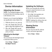
Go to adjust the brightness level. 3. Viewing Device Information
You can decrease the backlight timeout to adjust the contrast level (eTrex 10 only). Select Setup > About.
40
eTrex Owner's Manual Updating the Software
Before you can significantly reduce battery...
Owner's Manual - Page 47

... you can go near other ANT+ accessories.
• Bring the Garmin device within +/- 12 ft.
For example, your GPS location is activated. The total elevation distance ascended.
The maximum ascent rate in feet or meters per minute. eTrex Owner's Manual
47 or 10 m) away from only your
Appendix
accessory, and you turn on the...
Owner's Manual - Page 56

...-13 active route 13 avoidance 37 creating 12 deleting 13 editing 13 navigating 13 settings 36
S satellite signals 8, 26, 47,
49, 52 system settings 30 turning off GPS 26, 27
saving tracks 15
sharing data 24 Sight N' Go 10 software
updating 40 version 40 stopwatch 26 storing the device 42 sunrise and sunset...
Quick Start Manual - Page 2
... Back key ➌ Thumb Stick™ ➍ Menu key
➎ Power and backlight key
2
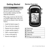
eTrex 10 Quick Start Manual Getting Started
Device Overview
‹ warning See the Important Safety and Product Information guide in...
Turn on the device (page 4).
3. Mark a waypoint (page 5).
6. Create a route (page 6).
7. When using your device the first time, you should complete these tasks ...
Quick Start Manual - Page 3
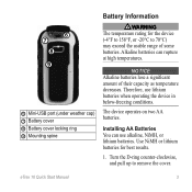
... remove the cover. Turn the D-ring counter-clockwise, and pull up to 70°C) may exceed the usable range of their capacity as temperature decreases. eTrex 10 Quick Start Manual
3 notice Alkaline batteries lose a significant amount of some batteries.
Installing AA Batteries You can rupture at high temperatures.
➏ ➐
➑ ➒...
Quick Start Manual - Page 4
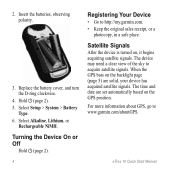
... batteries, observing polarity.
3. Select Setup > System > Battery
Type. 6. eTrex 10 Quick Start Manual
Turning the Device On or Off
Hold (page 2).
4
Registering Your Device
• Go to www.garmin.com/aboutGPS.
The time and date are solid, your device has acquired satellite signals. When the GPS bars on the backlight page (page 5) are set...
Quick Start Manual - Page 5
... an option:
• To save your current location as a waypoint.
1.
Select Go. For example, your device based on how you are using it. Select a waypoint.
3. eTrex 10 Quick Start Manual
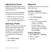
5 Adjusting the Screen
Note: The backlight brightness may be different when you are using the device for geocaching and for navigating on...
Quick Start Manual - Page 6
... Averaging.
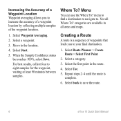
2. When the Sample Confidence status bar reaches 100%, select Save. menu to find a destination to navigate to save the route.
6
eTrex 10 Quick Start Manual Select back to . categories are available in the route. 4. Select a category. 3. Move to eight samples for the waypoint, waiting at least 90 minutes between samples. For best results...
Quick Start Manual - Page 7
... tracks more or less often.
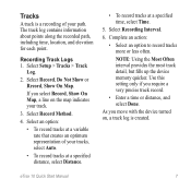
Recording Track Logs 1. Select Setup > Tracks > Track
Log.
2. Select an option:
• To record tracks at a specified time, select Time.
5. eTrex 10 Quick Start Manual
7 Select Record, Do Not Show or Record, Show On Map. Use this setting only if you move with the device turned on...
Quick Start Manual - Page 8
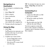
... Setup Map, and adjust the settings. Select a destination. 4. Navigate using the map.
1. The position icon represents your location on your route marked with a magenta line. 5. As you travel, the position icon moves.
2. Select a category. 3. The map page opens with your...Mac computers. Pull up the weather cap from the mini-USB port.
3. eTrex 10 Quick Start Manual Using the Map
1.
Quick Start Manual - Page 9
...Downloading Geocaches
1. Follow the on-screen instructions
to find and download geocaches to www.garmin.com/support
and click Contact Support for in . 5.
Sign in -country support information... of the owner's manual from your device. eTrex 10 Quick Start Manual
9 Contacting Garmin Product Support • Go to your Garmin dealer. Optional Accessories Optional accessories, such as ...
Similar Questions


Storage Problem On Gps Etrex 10
When I try to store anything on my eTrex 10, I get this message appear on the screen. "There is not ...
When I try to store anything on my eTrex 10, I get this message appear on the screen. "There is not ...
(Posted by derekhill108 8 years ago)

Unable To Download Gps Co-ordinates To My Etrex 10
I am now longer able to download co-ordinates to my Etrx 10 from the Geocaching website. When I try ...
I am now longer able to download co-ordinates to my Etrx 10 from the Geocaching website. When I try ...
(Posted by annbeattie 10 years ago)
