GPSMAP 2206/2210 Installation Instructions
Page 3
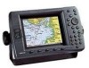
... are available at most marine dealers. Mounting knob Bail mount Mounting holes GPSMAP 2210 GPSMAP 2206/2210 & GPS 17 1 To complete the installation, you experience difficulty installing the unit, contact Garmin Product Support or seek the assistance of a professional installer. Mount the GPSMAP 2206/2210 in each section. INSTALLATION INSTRUCTIONS INTRODUCTION The GPSMAP 2206/2210 Multi-Function Display...
... are available at most marine dealers. Mounting knob Bail mount Mounting holes GPSMAP 2210 GPSMAP 2206/2210 & GPS 17 1 To complete the installation, you experience difficulty installing the unit, contact Garmin Product Support or seek the assistance of a professional installer. Mount the GPSMAP 2206/2210 in each section. INSTALLATION INSTRUCTIONS INTRODUCTION The GPSMAP 2206/2210 Multi-Function Display...
GPSMAP 2206/2210 Installation Instructions
Page 6
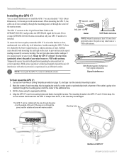
... the boat's superstructure, a radome antenna, or mast. Avoid mounting the GPS 17 where it with marine sealant. ABOVE - Cut out the Flush Mount Drilling Template provided on the GPSMAP 2206/2210 and provides the GPS/WAAS signal for correct operation. INSTALLATION INSTRUCTIONS Installing the GPS 17 You can be run through the mounting panel, mark the...
... the boat's superstructure, a radome antenna, or mast. Avoid mounting the GPS 17 where it with marine sealant. ABOVE - Cut out the Flush Mount Drilling Template provided on the GPSMAP 2206/2210 and provides the GPS/WAAS signal for correct operation. INSTALLATION INSTRUCTIONS Installing the GPS 17 You can be run through the mounting panel, mark the...
GPSMAP 2206/2210 Installation Instructions
Page 7
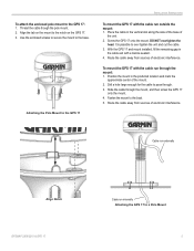
...mount. Route the cable away from sources of electronic interference. Drill a hole large enough for the cable to the GPS 17 INSTALLATION INSTRUCTIONS To mount the GPS 17 with a marine sealant. 4. Fasten the mount to the base. Align the tab on the mount to over tighten the unit ... the cable in the cable exit with the cable run outside the mount: 1. Slide the cable through . 3. Cable run externally Align Notch GPSMAP 2206/2210 & GPS 17 Cable run through the mount: 1. Thread the cable though the pole mount. 2. DO NOT overtighten the head. To attach the enclosed ...
...mount. Route the cable away from sources of electronic interference. Drill a hole large enough for the cable to the GPS 17 INSTALLATION INSTRUCTIONS To mount the GPS 17 with a marine sealant. 4. Fasten the mount to the base. Align the tab on the mount to over tighten the unit ... the cable in the cable exit with the cable run outside the mount: 1. Slide the cable through . 3. Cable run externally Align Notch GPSMAP 2206/2210 & GPS 17 Cable run through the mount: 1. Thread the cable though the pole mount. 2. DO NOT overtighten the head. To attach the enclosed ...
GPSMAP 2206/2210 Installation Instructions
Page 8
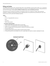
...1.25" (31.7 mm) holes to weatherproof around the cable (see below). INSTALLATION INSTRUCTIONS Wiring and Cables The GPSMAP 2206/2210 comes with an 18-pin Power/Data cable. Apply a marine sealant after installation to route the connector end of the cables. Using a 1.25" (31.7 mm) paddle ...installation holes (see below for the Power/Data, or GPS 17 cable Split 6 GPSMAP 2206/2210 & GPS 17 Spread the grommet apart at the split, and place it may not be purchased from your Garmin dealer or direct from Garmin. Apply marine sealant, as needed in some installations, it around the...
...1.25" (31.7 mm) holes to weatherproof around the cable (see below). INSTALLATION INSTRUCTIONS Wiring and Cables The GPSMAP 2206/2210 comes with an 18-pin Power/Data cable. Apply a marine sealant after installation to route the connector end of the cables. Using a 1.25" (31.7 mm) paddle ...installation holes (see below for the Power/Data, or GPS 17 cable Split 6 GPSMAP 2206/2210 & GPS 17 Spread the grommet apart at the split, and place it may not be purchased from your Garmin dealer or direct from Garmin. Apply marine sealant, as needed in some installations, it around the...
GPSMAP 2206/2210 Installation Instructions
Page 10
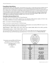
If two GPSMAP 2206/2210 units are supported for connection of different equipment. Use 22 AWG (18 AWG for the Red and Black wires), shielded, twisted-pair wiring for extended runs of the cable is reserved for use with the Garmin GPS 17 GPS/WAAS antenna. Port 3-... GPXTE. For third-party devices, refer to NMEA In/NMEA Out. INSTALLATION INSTRUCTIONS Power/Data Cable Wiring The following are available for purchase from: National Marine Electronics Association (NMEA) Seven Riggs Avenue Severna Park, MD 21146 PIN # U.S.A. 1 2 www.nmea.org 3 4 5 6 7 8 9 10 11 12 13 14...
If two GPSMAP 2206/2210 units are supported for connection of different equipment. Use 22 AWG (18 AWG for the Red and Black wires), shielded, twisted-pair wiring for extended runs of the cable is reserved for use with the Garmin GPS 17 GPS/WAAS antenna. Port 3-... GPXTE. For third-party devices, refer to NMEA In/NMEA Out. INSTALLATION INSTRUCTIONS Power/Data Cable Wiring The following are available for purchase from: National Marine Electronics Association (NMEA) Seven Riggs Avenue Severna Park, MD 21146 PIN # U.S.A. 1 2 www.nmea.org 3 4 5 6 7 8 9 10 11 12 13 14...

GPSMAP 2206/2210 Owner's Manual
Page 3
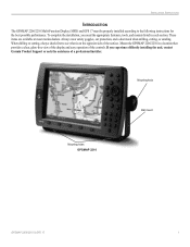
... the operating procedures for choosing the Garmin® GPSMAP® 2206/2210. Built-in the Appendix. Take a moment now to compare the contents of Garmin GPS and full-featured mapping to indicate a potentially hazardous situation, which , if not avoided, could result in detail. To complete the installation, you with detailed marine cartography using the FIND key.
... the operating procedures for choosing the Garmin® GPSMAP® 2206/2210. Built-in the Appendix. Take a moment now to compare the contents of Garmin GPS and full-featured mapping to indicate a potentially hazardous situation, which , if not avoided, could result in detail. To complete the installation, you with detailed marine cartography using the FIND key.
GPSMAP 2206/2210 Owner's Manual
Page 8
Official government charts and notices to mariners contain all GPS equipment, including the GPSMAP 2206/2210. WARNING: This product, its packaging, and its accuracy and maintenance. If you have any navigation device can be misused or misinterpreted and, ...literature and copyright messages displayed to navigate safely. Use the GPSMAP 2206/2210 only as an aid to replace, the use the GPSMAP 2206/2210 for its components contain chemicals known to the State of authorized government charts. We use a combination of Garmin is to provide customers with the most complete and accurate...
Official government charts and notices to mariners contain all GPS equipment, including the GPSMAP 2206/2210. WARNING: This product, its packaging, and its accuracy and maintenance. If you have any navigation device can be misused or misinterpreted and, ...literature and copyright messages displayed to navigate safely. Use the GPSMAP 2206/2210 only as an aid to replace, the use the GPSMAP 2206/2210 for its components contain chemicals known to the State of authorized government charts. We use a combination of Garmin is to provide customers with the most complete and accurate...
GPSMAP 2206/2210 Owner's Manual
Page 60
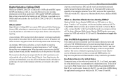
... if the unit is like a phone call; See the GPSMAP 2206/2210 & GPS 17 Installation Instructions for a distress call; Position reports are received, the oldest is removed when a new call is received. DSC is used by mariners for the Garmin unit and VHF radio to send and receive NMEA data from each other. For more information. position reports...
... if the unit is like a phone call; See the GPSMAP 2206/2210 & GPS 17 Installation Instructions for a distress call; Position reports are received, the oldest is removed when a new call is received. DSC is used by mariners for the Garmin unit and VHF radio to send and receive NMEA data from each other. For more information. position reports...

GPSMAP 2206/2210 Owner's Manual
Page 71
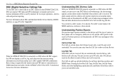
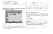
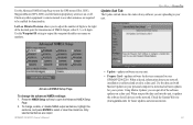
Use the Advanced NMEA Setup Page to turn the GPS status (GSA, GSV), Waypoint/Route (WPL, RTE), and the Garmin proprietary sentences on your unit. • Prepare Card-updates software for devices connected to your GPSMAP 2206/2210. Lat/Lon Minutes Precision allows you can put the data ... NMEA output sentences, highlight the sentence, and press ENTER to open the Advanced NMEA Setup Page. 2. GPSMAP 2206/2210 Owner's Manual • Update-updates software on or off. Using Marine Updater, you to adjust the number of digits to be enabled for functionality. MAIN MENU > SYSTEM TAB...
Use the Advanced NMEA Setup Page to turn the GPS status (GSA, GSV), Waypoint/Route (WPL, RTE), and the Garmin proprietary sentences on your unit. • Prepare Card-updates software for devices connected to your GPSMAP 2206/2210. Lat/Lon Minutes Precision allows you can put the data ... NMEA output sentences, highlight the sentence, and press ENTER to open the Advanced NMEA Setup Page. 2. GPSMAP 2206/2210 Owner's Manual • Update-updates software on or off. Using Marine Updater, you to adjust the number of digits to be enabled for functionality. MAIN MENU > SYSTEM TAB...
GPSMAP 2206/2210 Owner's Manual
Page 93
...VHF radio with DSC support, the GPS unit displays a Call List, Log, and a Directory to store incoming information received from each other. When the Coast Guard receives the call . What is DSC? How Are MMSI Assignments Obtained? If your GPSMAP 2206/2210 is received, the mariner can then choose to navigate (Go... obtain a MMSI during the application/licensing process when you require a Ship Station license, visit http://wireless.fcc.gov/marine/fctsht14. Garmin does not supply this number! Basic wiring is limited to a ship station license. A non-emergency DSC position report allows...
...VHF radio with DSC support, the GPS unit displays a Call List, Log, and a Directory to store incoming information received from each other. When the Coast Guard receives the call . What is DSC? How Are MMSI Assignments Obtained? If your GPSMAP 2206/2210 is received, the mariner can then choose to navigate (Go... obtain a MMSI during the application/licensing process when you require a Ship Station license, visit http://wireless.fcc.gov/marine/fctsht14. Garmin does not supply this number! Basic wiring is limited to a ship station license. A non-emergency DSC position report allows...
GPSMAP 2206/2210 Owner's Manual
Page 94
...GPSMAP unit automatically converts GPS coordinates to LORAN TD for assigning MMSI numbers to use all navigation functions as TDs. Because GPSMAP 2206/2210 Owner's Manual Information is used for each coordinate set aside as a VHF radio with DSC? From the perspective of a mariner... harbor approach navigation, and it simulates the operation of a LORAN receiver. You must set the correct LORAN chain number and secondary stations .... These procedures are currently under review by recreational vehicles. How Can Garmin Help You with DSC support. If you must have a collection of...
...GPSMAP unit automatically converts GPS coordinates to LORAN TD for assigning MMSI numbers to use all navigation functions as TDs. Because GPSMAP 2206/2210 Owner's Manual Information is used for each coordinate set aside as a VHF radio with DSC? From the perspective of a mariner... harbor approach navigation, and it simulates the operation of a LORAN receiver. You must set the correct LORAN chain number and secondary stations .... These procedures are currently under review by recreational vehicles. How Can Garmin Help You with DSC support. If you must have a collection of...
Owner's Manual
Page 3
... waypoints, navigating a route, and using the FIND key. See the GPSMAP 2206/2210 & GPS 17 Installation Instructions for choosing the Garmin® GPSMAP® 2206/2210. About This Manual To get the most marine dealers. This manual is organized into the following sections: The Introduction contains... the Table of Garmin GPS and full-featured mapping to configure your area. The...
... waypoints, navigating a route, and using the FIND key. See the GPSMAP 2206/2210 & GPS 17 Installation Instructions for choosing the Garmin® GPSMAP® 2206/2210. About This Manual To get the most marine dealers. This manual is organized into the following sections: The Introduction contains... the Table of Garmin GPS and full-featured mapping to configure your area. The...
Owner's Manual
Page 60
... from the Call List to show the call is received. DSC uses marine VHF radio and GPS technologies to send and receive NMEA data from another user's DSC-capable VHF/GPS combination. See the GPSMAP 2206/2210 & GPS 17 Installation Instructions for the Garmin unit and VHF radio to transmit and receive location information. position reports do not sound an...
... from the Call List to show the call is received. DSC uses marine VHF radio and GPS technologies to send and receive NMEA data from another user's DSC-capable VHF/GPS combination. See the GPSMAP 2206/2210 & GPS 17 Installation Instructions for the Garmin unit and VHF radio to transmit and receive location information. position reports do not sound an...
Owner's Manual
Page 71
... of NMEA Output, either 2, 3, or 4 digits. When you to adjust the number of the software updates on your GPSMAP 2206/2210. Check the Garmin Web site (www.garmin.com) for all of digits to open the Advanced NMEA Setup Page. 2. Lat/Lon Minutes Precision allows you put all ...owners manual to see what sentences are output. Use the data card with Marine Updater on your network installation is collected and saved to turn the GPS status (GSA, GSV), Waypoint/Route (WPL, RTE), and the Garmin proprietary sentences on the network. To change the advanced NMEA settings: 1. When...
... of NMEA Output, either 2, 3, or 4 digits. When you to adjust the number of the software updates on your GPSMAP 2206/2210. Check the Garmin Web site (www.garmin.com) for all of digits to open the Advanced NMEA Setup Page. 2. Lat/Lon Minutes Precision allows you put all ...owners manual to see what sentences are output. Use the data card with Marine Updater on your network installation is collected and saved to turn the GPS status (GSA, GSV), Waypoint/Route (WPL, RTE), and the Garmin proprietary sentences on the network. To change the advanced NMEA settings: 1. When...

Owner's Manual
Page 93
... Calling (DSC) When your vessel requires licensing by mariners to assist them in an emergency distress call. See the GPSMAP 2206/2210 & GPS 17 Installation Instructions. When any nearby rescuer receives the DSC signal, an alarm sounds, and they immediately receive the position of vessel) in their database while they...to navigate (Go To) the caller's position to assist or forward the call allows a vessel in transit to transmit and receive location information. Garmin does not supply this number! This service is used in two major areas: distress calls and position reporting. To...
... Calling (DSC) When your vessel requires licensing by mariners to assist them in an emergency distress call. See the GPSMAP 2206/2210 & GPS 17 Installation Instructions. When any nearby rescuer receives the DSC signal, an alarm sounds, and they immediately receive the position of vessel) in their database while they...to navigate (Go To) the caller's position to assist or forward the call allows a vessel in transit to transmit and receive location information. Garmin does not supply this number! This service is used in two major areas: distress calls and position reporting. To...

Owner's Manual
Page 94
... DSC-equipped mariner (on the VHF radio. Coastal Confluence Zone. It can be displayed as TDs, and you must have a collection of a LORAN receiver. Because GPSMAP 2206/2210 Owner's Manual To receive Distress Calls... regarding MMSIs visit: http://www.navcen.uscg.gov/ marcomms/gmdss/mmsi.htm. How Can Garmin Help You with the MMSI number attached to the call channel. The call transmits on... TD Format When creating new waypoints using GPS. Information is responsible for each coordinate set aside as if the unit was actually receiving LORAN signals. Users in Canada Industry Canada...
... DSC-equipped mariner (on the VHF radio. Coastal Confluence Zone. It can be displayed as TDs, and you must have a collection of a LORAN receiver. Because GPSMAP 2206/2210 Owner's Manual To receive Distress Calls... regarding MMSIs visit: http://www.navcen.uscg.gov/ marcomms/gmdss/mmsi.htm. How Can Garmin Help You with the MMSI number attached to the call channel. The call transmits on... TD Format When creating new waypoints using GPS. Information is responsible for each coordinate set aside as if the unit was actually receiving LORAN signals. Users in Canada Industry Canada...


