GPSMAP 2206/2210 Installation Instructions
Page 6
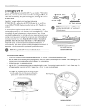
... GPS 17 connects to the 18-pin Power/Data Cable on the selected mounting location. 2. With correct operation verified, permanently mount the unit. EMI BETTER BEST GOOD SS JAYHAWK EMI (Electromagnetic Interference) from (preferably above ) the path of the unit. Cut out the Flush Mount Drilling Template provided on page 13, and tape it on the GPSMAP 2206/2210 and provides the GPS/WAAS signal for correct operation. The GPS...
... GPS 17 connects to the 18-pin Power/Data Cable on the selected mounting location. 2. With correct operation verified, permanently mount the unit. EMI BETTER BEST GOOD SS JAYHAWK EMI (Electromagnetic Interference) from (preferably above ) the path of the unit. Cut out the Flush Mount Drilling Template provided on page 13, and tape it on the GPSMAP 2206/2210 and provides the GPS/WAAS signal for correct operation. The GPS...
GPSMAP 2206/2210 Installation Instructions
Page 7
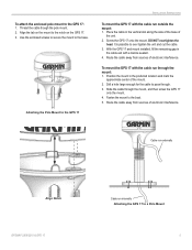
Use the enclosed screws to secure the mount to the GPS 17: 1. Route the cable away from sources of electronic interference. Position the mount in the preferred location and mark the approximate center of the unit. 2. Route the cable away from sources of electronic interference. Thread the cable though the pole mount. 2. DO NOT overtighten the head. Cable run externally Align Notch GPSMAP 2206/2210 & GPS 17 Cable run through the mount: 1. To...
Use the enclosed screws to secure the mount to the GPS 17: 1. Route the cable away from sources of electronic interference. Position the mount in the preferred location and mark the approximate center of the unit. 2. Route the cable away from sources of electronic interference. Thread the cable though the pole mount. 2. DO NOT overtighten the head. Cable run externally Align Notch GPSMAP 2206/2210 & GPS 17 Cable run through the mount: 1. To...
GPSMAP 2206/2210 Installation Instructions
Page 10
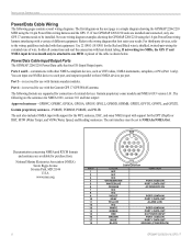
... (POWER/DATA) GPSMAP 2206/2210 & GPS 17 The following are installed and connected, only one GPS 17 antenna needs to be set to the wiring diagram that equipment. Power/Data Cable Input/Output Ports The GPSMAP 2206/2210 Power/Data cable has four I/O (Input/Output) ports. The unit also includes NMEA input with support for the WPL sentence, DSC, and sonar NMEA input with the Garmin GPS 17 GPS/WAAS antenna. Use 22 AWG (18 AWG for the Red and Black wires), shielded, twisted-pair wiring for the DPT (Depth) or DBT, MTW (Water Temp), and...
... (POWER/DATA) GPSMAP 2206/2210 & GPS 17 The following are installed and connected, only one GPS 17 antenna needs to be set to the wiring diagram that equipment. Power/Data Cable Input/Output Ports The GPSMAP 2206/2210 Power/Data cable has four I/O (Input/Output) ports. The unit also includes NMEA input with support for the WPL sentence, DSC, and sonar NMEA input with the Garmin GPS 17 GPS/WAAS antenna. Use 22 AWG (18 AWG for the Red and Black wires), shielded, twisted-pair wiring for the DPT (Depth) or DBT, MTW (Water Temp), and...

GPSMAP 2206/2210 Owner's Manual
Page 3
... install the GPSMAP 2206/2210, refer to avoid unsafe practices. Manual Conventions This manual uses the term Warning to alert you need the appropriate fasteners, tools, and mounts listed in each page in detail. i Installation items not provided by -step instructions such as creating and using waypoints, navigating a route, and using the pages. This manual uses the term Caution to configure your new chartplotter, read this package with detailed marine cartography using BlueChart...
... install the GPSMAP 2206/2210, refer to avoid unsafe practices. Manual Conventions This manual uses the term Warning to alert you need the appropriate fasteners, tools, and mounts listed in each page in detail. i Installation items not provided by -step instructions such as creating and using waypoints, navigating a route, and using the pages. This manual uses the term Caution to configure your new chartplotter, read this package with detailed marine cartography using BlueChart...
GPSMAP 2206/2210 Owner's Manual
Page 60
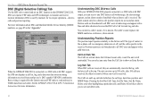
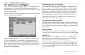
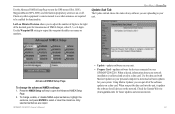
... that stores incoming information received from each other. Log Sub Tab When DSC calls are received, they are not broadcasted to all DSC users in radio range and appear with DSC output, you to sort and delete calls. 52 GPSMAP 2206/2210 Owner's Manual Basic wiring is required for more information about DSC and Maritime Mobile Service Identity (MMSI) numbers, see page 85 in the log, with DSC support, the GPS unit displays a call at...
... that stores incoming information received from each other. Log Sub Tab When DSC calls are received, they are not broadcasted to all DSC users in radio range and appear with DSC output, you to sort and delete calls. 52 GPSMAP 2206/2210 Owner's Manual Basic wiring is required for more information about DSC and Maritime Mobile Service Identity (MMSI) numbers, see page 85 in the log, with DSC support, the GPS unit displays a call at...
GPSMAP 2206/2210 Owner's Manual
Page 67
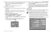
...-shows the unit's software, basemap version, and electronic serial number. • Update Notes-shows software notes for the current software version. • Factory Dflts-restores all devices on the ROCKER to Garmin's original setup values for the map or chart. The following soft keys are using a map or chart with your GPS, make sure the settings on the GPSMAP 2206/2210. Enter the offset minutes for Position Format, Depth, Map Datum, Temperature, Distance, Speed, and Elevation, Pressure, and Heading. Units Sub Tab Use...
...-shows the unit's software, basemap version, and electronic serial number. • Update Notes-shows software notes for the current software version. • Factory Dflts-restores all devices on the ROCKER to Garmin's original setup values for the map or chart. The following soft keys are using a map or chart with your GPS, make sure the settings on the GPSMAP 2206/2210. Enter the offset minutes for Position Format, Depth, Map Datum, Temperature, Distance, Speed, and Elevation, Pressure, and Heading. Units Sub Tab Use...
GPSMAP 2206/2210 Owner's Manual
Page 70
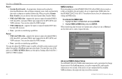
... input/output NMEA data. MAIN MENU > SYSTEM TAB Port 1 • Garmin Data Transfer-the proprietary format used to upload or download MapSource data, exchange waypoint, route, track, and proximity data with a NMEA device (such as a radio or autopilot), the unit needs to be customized to change the precision of the Lat/Lon minutes, set up to use this option. You can choose from nine Garmin Data Transfer Modes. • NMEA In/NMEA Out-supports the input or output of standard NMEA 0183 data, DSC, and sonar NMEA input support for most AIS receivers...
... input/output NMEA data. MAIN MENU > SYSTEM TAB Port 1 • Garmin Data Transfer-the proprietary format used to upload or download MapSource data, exchange waypoint, route, track, and proximity data with a NMEA device (such as a radio or autopilot), the unit needs to be customized to change the precision of the Lat/Lon minutes, set up to use this option. You can choose from nine Garmin Data Transfer Modes. • NMEA In/NMEA Out-supports the input or output of standard NMEA 0183 data, DSC, and sonar NMEA input support for most AIS receivers...
GPSMAP 2206/2210 Owner's Manual
Page 93
... a "call , they immediately receive the position of one another user's DSC capable VHF/GPS combination. GPSMAP 2206/2210 Owner's Manual 85 Basic wiring is received, the mariner can store that location and quickly navigate to act like a phone number when used in a Position Report and as who travel outside the U.S.A. html. See the GPSMAP 2206/2210 & GPS 17 Installation Instructions. Maritime Mobile Service Identity (MMSI) allows a VHF radio to that position using a Go To. When a DSC position is required for a ship...
... a "call , they immediately receive the position of one another user's DSC capable VHF/GPS combination. GPSMAP 2206/2210 Owner's Manual 85 Basic wiring is received, the mariner can store that location and quickly navigate to act like a phone number when used in a Position Report and as who travel outside the U.S.A. html. See the GPSMAP 2206/2210 & GPS 17 Installation Instructions. Maritime Mobile Service Identity (MMSI) allows a VHF radio to that position using a Go To. When a DSC position is required for a ship...

GPSMAP 2206/2210 Owner's Manual
Page 98
... Alarms The GPSMAP 2206/2210 uses an on-screen message system to notify you of 100 contacts. Contact your dealer or Garmin Product Support. Distress Call-a DSC distress call has been received. This alarm does not show a message banner. Check the connections. Can't Read Voltages That Low, Limited To Bottom Of Range-voltage range must enter an appropriate Keel Offset for the GPSMAP 2206/2210. Directory Memory is data to transfer user data from a destination waypoint...
... Alarms The GPSMAP 2206/2210 uses an on-screen message system to notify you of 100 contacts. Contact your dealer or Garmin Product Support. Distress Call-a DSC distress call has been received. This alarm does not show a message banner. Check the connections. Can't Read Voltages That Low, Limited To Bottom Of Range-voltage range must enter an appropriate Keel Offset for the GPSMAP 2206/2210. Directory Memory is data to transfer user data from a destination waypoint...
GPSMAP 2206/2210 Owner's Manual
Page 99
... Working-the speed sensor is full. Water Temperature Alarm-sonar has reported a temperature above, below, inside, or outside the specified values. Waypoint Memory Is Full, Can't Create Waypoint-you entered a saved track name that already exists in memory. Proximity Alarm: -you are removed. Contact your dealer or Garmin Product Support to transfer user data without deleting old data. Track Already Exists: -you have the unit serviced. The oldest track log points were deleted to needs a software update. User Card Not...
... Working-the speed sensor is full. Water Temperature Alarm-sonar has reported a temperature above, below, inside, or outside the specified values. Waypoint Memory Is Full, Can't Create Waypoint-you entered a saved track name that already exists in memory. Proximity Alarm: -you are removed. Contact your dealer or Garmin Product Support to transfer user data without deleting old data. Track Already Exists: -you have the unit serviced. The oldest track log points were deleted to needs a software update. User Card Not...
GPSMAP 2206/2210 Owner's Manual
Page 104
... proximity waypoints 19 clearing 19 proximity waypoint list 18 Q QUICK NAV route 25 QUIT key 2 R re-evaluate route 25 receiver status 6 replace from card 55 review waypoint page 15 ROCKER key 2 routes 23-29 copying 25 creating 23 deleting 26 editing 26 navigating 24 planning 29 quick nav 25 Routes tab 50 S saved tracks 51 scale, log and graph 81 scroll bar 8 serial number electronic 59 Setup tab 58 set position 6 shallow water alarm 58 GPSMAP 2206/2210 Owner's Manual
... proximity waypoints 19 clearing 19 proximity waypoint list 18 Q QUICK NAV route 25 QUIT key 2 R re-evaluate route 25 receiver status 6 replace from card 55 review waypoint page 15 ROCKER key 2 routes 23-29 copying 25 creating 23 deleting 26 editing 26 navigating 24 planning 29 quick nav 25 Routes tab 50 S saved tracks 51 scale, log and graph 81 scroll bar 8 serial number electronic 59 Setup tab 58 set position 6 shallow water alarm 58 GPSMAP 2206/2210 Owner's Manual
Owner's Manual
Page 3
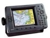
... GPSMAP 2206/2210. An Index is provided at most out of Garmin GPS and full-featured mapping to the GPSMAP 2206/2210 & GPS 17 Installation Instructions. Introduction Thank you for more information. The GPSMAP 2206/2210 uses the proven performance of your unit in coverage is a non-network chartplotter that provides basic working knowledge needed to use it to two optional data cards for loading additional map coverage of the manual for your new chartplotter, read...
... GPSMAP 2206/2210. An Index is provided at most out of Garmin GPS and full-featured mapping to the GPSMAP 2206/2210 & GPS 17 Installation Instructions. Introduction Thank you for more information. The GPSMAP 2206/2210 uses the proven performance of your unit in coverage is a non-network chartplotter that provides basic working knowledge needed to use it to two optional data cards for loading additional map coverage of the manual for your new chartplotter, read...
Owner's Manual
Page 60
... position reporting. Position reports are received, the oldest is removed when a new call is used by mariners for the Garmin unit and VHF radio to send and receive NMEA data from the Call List to show the call . Main Menu > DSC (Digital Selective Calling) Tab DSC (Digital Selective Calling) Tab Use the DSC tab to control and set off, and the call is connected to sort and delete calls. 52 GPSMAP 2206/2210 Owner's Manual For more information...
... position reporting. Position reports are received, the oldest is removed when a new call is used by mariners for the Garmin unit and VHF radio to send and receive NMEA data from the Call List to show the call . Main Menu > DSC (Digital Selective Calling) Tab DSC (Digital Selective Calling) Tab Use the DSC tab to control and set off, and the call is connected to sort and delete calls. 52 GPSMAP 2206/2210 Owner's Manual For more information...

Owner's Manual
Page 67
...: The Units sub tab settings affect how navigation information appears on the map or chart. GPSMAP 2206/2210 Owner's Manual 59 To adjust the offset minutes, select the minutes field, and press ENTER. 7. Using the ROCKER, highlight On, and press ENTER. 3. Enter the offset minutes for the unit's on the network. If zero, the unit automatically changes to Garmin's original setup values for the current software version. • Factory Dflts-restores all devices on -screen text. Sliders Main Menu...
...: The Units sub tab settings affect how navigation information appears on the map or chart. GPSMAP 2206/2210 Owner's Manual 59 To adjust the offset minutes, select the minutes field, and press ENTER. 7. Using the ROCKER, highlight On, and press ENTER. 3. Enter the offset minutes for the unit's on the network. If zero, the unit automatically changes to Garmin's original setup values for the current software version. • Factory Dflts-restores all devices on -screen text. Sliders Main Menu...

Owner's Manual
Page 70
... NMEA sentences, the output rate may exceed two seconds. 62 GPSMAP 2206/2210 Owner's Manual Main Menu > System Tab Port 1 • Garmin Data Transfer-the proprietary format used to upload or download MapSource data, exchange waypoint, route, track, and proximity data with a NMEA device (such as a radio or autopilot), the unit needs to be customized to change the precision of standard NMEA 0183 data, DSC, and sonar NMEA input support for most AIS receivers. • None-provides no interfacing capabilities. See the GPSMAP 2206/2210 & GPS 17 Installation Instructions...
... NMEA sentences, the output rate may exceed two seconds. 62 GPSMAP 2206/2210 Owner's Manual Main Menu > System Tab Port 1 • Garmin Data Transfer-the proprietary format used to upload or download MapSource data, exchange waypoint, route, track, and proximity data with a NMEA device (such as a radio or autopilot), the unit needs to be customized to change the precision of standard NMEA 0183 data, DSC, and sonar NMEA input support for most AIS receivers. • None-provides no interfacing capabilities. See the GPSMAP 2206/2210 & GPS 17 Installation Instructions...
Owner's Manual
Page 71
..., information about your network installation is collected and saved to output the waypoint identifiers as names or numbers. When you can put the data card into the unit, it updates the software for your unit. Use the Advanced NMEA Setup Page to turn the GPS status (GSA, GSV), Waypoint/Route (WPL, RTE), and the Garmin proprietary sentences on the network. GPSMAP 2206/2210 Owner's Manual • Update-updates software on your personal computer to your system. Use the Waypoint ID setting to a data card. Only...
..., information about your network installation is collected and saved to output the waypoint identifiers as names or numbers. When you can put the data card into the unit, it updates the software for your unit. Use the Advanced NMEA Setup Page to turn the GPS status (GSA, GSV), Waypoint/Route (WPL, RTE), and the Garmin proprietary sentences on the network. GPSMAP 2206/2210 Owner's Manual • Update-updates software on your personal computer to your system. Use the Waypoint ID setting to a data card. Only...

Owner's Manual
Page 93
... station license, or an amendment to send and receive NMEA data from another . To find out if you file FCC Forms 159 and 605. To use DSC, users must apply for the Garmin unit and VHF radio to a ship station license. The FCC and Coast Guard have a FCC ship station license. Basic wiring is limited to transmit and receive location information. See the GPSMAP 2206/2210 & GPS 17 Installation Instructions.
... station license, or an amendment to send and receive NMEA data from another . To find out if you file FCC Forms 159 and 605. To use DSC, users must apply for the Garmin unit and VHF radio to a ship station license. The FCC and Coast Guard have a FCC ship station license. Basic wiring is limited to transmit and receive location information. See the GPSMAP 2206/2210 & GPS 17 Installation Instructions.
Owner's Manual
Page 98
Anchor Drag Alarm-you must enter an appropriate Keel Offset for the transducer. Can't Write User Card-error writing to add new ones. Directory Memory is a problem with the GPS antenna wiring. Drift Alarm-the depth has changed by the amount of the Drift Alarm value. Lost Satellite Reception-the unit has lost satellite signals. None Found-no data matched the search criteria. 90 GPSMAP 2206/2210 Owner's Manual Can't Read Voltages That High, Limited To Top Of Range-voltage range must be between 10...
Anchor Drag Alarm-you must enter an appropriate Keel Offset for the transducer. Can't Write User Card-error writing to add new ones. Directory Memory is a problem with the GPS antenna wiring. Drift Alarm-the depth has changed by the amount of the Drift Alarm value. Lost Satellite Reception-the unit has lost satellite signals. None Found-no data matched the search criteria. 90 GPSMAP 2206/2210 Owner's Manual Can't Read Voltages That High, Limited To Top Of Range-voltage range must be between 10...

Owner's Manual
Page 99
Not All Maps Fit, Some Maps will not be drawn-the maximum number of points or create a second route. Modify the route name or delete the previous route name. Shallow Water Alarm-the Shallow Water Alarm depth has been reached. Simulating Operation-the unit is full. Sonar Service Incompatible-the external sonar device you are removed. The oldest track log points were deleted to needs a software update. Transfer Complete-the unit has finished uploading or downloading information to transfer user data without deleting old data. User Card Not...
Not All Maps Fit, Some Maps will not be drawn-the maximum number of points or create a second route. Modify the route name or delete the previous route name. Shallow Water Alarm-the Shallow Water Alarm depth has been reached. Simulating Operation-the unit is full. Sonar Service Incompatible-the external sonar device you are removed. The oldest track log points were deleted to needs a software update. Transfer Complete-the unit has finished uploading or downloading information to transfer user data without deleting old data. User Card Not...
Owner's Manual
Page 104
... proximity waypoints 19 clearing 19 proximity waypoint list 18 Q QUICK NAV route 25 QUIT key 2 R re-evaluate route 25 receiver status 6 replace from card 55 review waypoint page 15 ROCKER key 2 routes 23-29 copying 25 creating 23 deleting 26 editing 26 navigating 24 planning 29 quick nav 25 Routes tab 50 S saved tracks 51 scale, log and graph 81 scroll bar 8 serial number electronic 59 Setup tab 58 set position 6 shallow water alarm 58 GPSMAP 2206/2210 Owner's Manual
... proximity waypoints 19 clearing 19 proximity waypoint list 18 Q QUICK NAV route 25 QUIT key 2 R re-evaluate route 25 receiver status 6 replace from card 55 review waypoint page 15 ROCKER key 2 routes 23-29 copying 25 creating 23 deleting 26 editing 26 navigating 24 planning 29 quick nav 25 Routes tab 50 S saved tracks 51 scale, log and graph 81 scroll bar 8 serial number electronic 59 Setup tab 58 set position 6 shallow water alarm 58 GPSMAP 2206/2210 Owner's Manual


