GPSMAP 2206/2210 Owner's Manual
Page 4
... Manual i Manual Conventions i Product Registration v Contact Garmin...v Software License Agreement v Warning ...iv Caution ...iv Getting Started 1 Unit Overview 1 Using the GPSMAP 2206/2210 Keypad 2 Using Soft Keys...3 Using Data Entry/Shortcut Keys 3 Status Bar...3 Turning on the GPSMAP 2206/2210 4 Adjusting the Backlight 4 Initializing the GPS Receiver 5 Receiver Status and Accuracy 6 GPS Setup...6 Using Simulator Mode 7 Basic Operation 8 Using...
... Manual i Manual Conventions i Product Registration v Contact Garmin...v Software License Agreement v Warning ...iv Caution ...iv Getting Started 1 Unit Overview 1 Using the GPSMAP 2206/2210 Keypad 2 Using Soft Keys...3 Using Data Entry/Shortcut Keys 3 Status Bar...3 Turning on the GPSMAP 2206/2210 4 Adjusting the Backlight 4 Initializing the GPS Receiver 5 Receiver Status and Accuracy 6 GPS Setup...6 Using Simulator Mode 7 Basic Operation 8 Using...
GPSMAP 2206/2210 Owner's Manual
Page 5
...Highway Page 41 Changing the Highway Perspective Range 41 Highway Page Options 41 Showing or Hiding Cartography 42 Main Menu 43 GPS Tab...43 Tide Tab ...44 Tide Sub Tab ...44 Current Sub Tab ...46 Celestial Tab 47 Trip Tab...48 ...Tab ...50 Tracks Tab...50 DSC (Digital Selective Calling) Tab 52 Understanding DSC Distress Calls 52 Understanding Position Reports 52 Review DSC Waypoint 53 Setting Up DSC ...54 Using the NAV Key 54 Card Tab ...54 Messages Tab 55 Viewing Detailed ...Tab ...78 General Sub Tab ...79 Graph Sub Tab ...80 Water Temp Sub Tab 81 GPSMAP 2206/2210 Owner's Manual iii
...Highway Page 41 Changing the Highway Perspective Range 41 Highway Page Options 41 Showing or Hiding Cartography 42 Main Menu 43 GPS Tab...43 Tide Tab ...44 Tide Sub Tab ...44 Current Sub Tab ...46 Celestial Tab 47 Trip Tab...48 ...Tab ...50 Tracks Tab...50 DSC (Digital Selective Calling) Tab 52 Understanding DSC Distress Calls 52 Understanding Position Reports 52 Review DSC Waypoint 53 Setting Up DSC ...54 Using the NAV Key 54 Card Tab ...54 Messages Tab 55 Viewing Detailed ...Tab ...78 General Sub Tab ...79 Graph Sub Tab ...80 Water Temp Sub Tab 81 GPSMAP 2206/2210 Owner's Manual iii
GPSMAP 2206/2210 Owner's Manual
Page 18
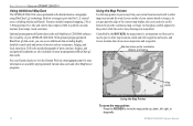
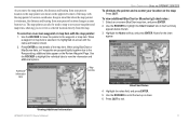
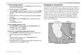
...to pan away from your Garmin dealer or visit the Garmin Web site (www.garmin.com) for U.S. Optional preprogrammed Garmin data cards and MapSource CD...cards. BASIC OPERATION > USING THE GPSMAP 2206/2210 Using Additional Map Data The GPSMAP 2206/2210 comes preloaded with detailed marine cartography using BlueChart® g2 technology...review location data of interest such as restaurants, lodging, and local attractions. Map item name, pointer coordinates, distance, and bearing Map pointer Using the Map Pointer To move the map pointer up, down, left, right, or diagonally. 10 GPSMAP 2206...
...to pan away from your Garmin dealer or visit the Garmin Web site (www.garmin.com) for U.S. Optional preprogrammed Garmin data cards and MapSource CD...cards. BASIC OPERATION > USING THE GPSMAP 2206/2210 Using Additional Map Data The GPSMAP 2206/2210 comes preloaded with detailed marine cartography using BlueChart® g2 technology...review location data of interest such as restaurants, lodging, and local attractions. Map item name, pointer coordinates, distance, and bearing Map pointer Using the Map Pointer To move the map pointer up, down, left, right, or diagonally. 10 GPSMAP 2206...
GPSMAP 2206/2210 Owner's Manual
Page 19
...view details of the map, with the map pointer's location coordinates. To view additional BlueChart or Bluechart g2 chart notes: 1. Viewing Additional Information GPSMAP 2206/2210 Owner's Manual 11 The map pointer can also be used to snap to on -screen BlueChart map item, and press ENTER. 2. When...screen with the map pointer: 1. Use the ROCKER to highlight the Chart tab. As you to review a selected location directly from your present location changes as your location on the Review Waypoint Page. Keep in the upper-left corner of the map item. When using BlueChart or MapSource...
...view details of the map, with the map pointer's location coordinates. To view additional BlueChart or Bluechart g2 chart notes: 1. Viewing Additional Information GPSMAP 2206/2210 Owner's Manual 11 The map pointer can also be used to snap to on -screen BlueChart map item, and press ENTER. 2. When...screen with the map pointer: 1. Use the ROCKER to highlight the Chart tab. As you to review a selected location directly from your present location changes as your location on the Review Waypoint Page. Keep in the upper-left corner of the map item. When using BlueChart or MapSource...
GPSMAP 2206/2210 Owner's Manual
Page 20
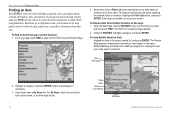
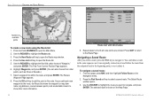
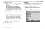
... within the map outline area to spell out the name, or scroll through the list. 12 Chart name Distance and bearing Soft keys GPSMAP 2206/2210 Owner's Manual The Review Page appears, showing item information, map location, chart name, distance/bearing, and options for items including waypoints, cities, geographic points, celestial information, tides...
... within the map outline area to spell out the name, or scroll through the list. 12 Chart name Distance and bearing Soft keys GPSMAP 2206/2210 Owner's Manual The Review Page appears, showing item information, map location, chart name, distance/bearing, and options for items including waypoints, cities, geographic points, celestial information, tides...
GPSMAP 2206/2210 Owner's Manual
Page 21
... your current location. The GPSMAP 2206/2210 captures its current location and creates a default name and symbol for the new waypoint. 2. BASIC OPERATION > CREATING AND USING WAYPOINTS Review Waypoint Page Creating Waypoints Using the Map You can create waypoints using a Garmin GSD 21 or GSD 22...move the pointer over a map item, you see a highlighted description of the available waypoint information, see page 16. GPSMAP 2206/2210 Owner's Manual 13 The Review Waypoint Page appears. 3. To accept the waypoint with the default information, press ENTER. Use the ROCKER to quickly mark...
... your current location. The GPSMAP 2206/2210 captures its current location and creates a default name and symbol for the new waypoint. 2. BASIC OPERATION > CREATING AND USING WAYPOINTS Review Waypoint Page Creating Waypoints Using the Map You can create waypoints using a Garmin GSD 21 or GSD 22...move the pointer over a map item, you see a highlighted description of the available waypoint information, see page 16. GPSMAP 2206/2210 Owner's Manual 13 The Review Waypoint Page appears. 3. To accept the waypoint with the default information, press ENTER. Use the ROCKER to quickly mark...
GPSMAP 2206/2210 Owner's Manual
Page 22
...Review Page for creating a waypoint at a specific latitude/longitude position from the datum in which the coordinates were created can manually enter position coordinates to capture the pointer location. This method is useful for the selected map feature appears. 3. Entering coordinates into the GPSMAP 2206... OPERATION > CREATING AND USING WAYPOINTS To create a new waypoint from a Map Feature 14 Review Waypoint Page To create a new waypoint by entering position coordinates: 1. Enter location coordinates manually. Highlight the Points tab. GPSMAP 2206/2210 Owner's Manual
...Review Page for creating a waypoint at a specific latitude/longitude position from the datum in which the coordinates were created can manually enter position coordinates to capture the pointer location. This method is useful for the selected map feature appears. 3. Entering coordinates into the GPSMAP 2206... OPERATION > CREATING AND USING WAYPOINTS To create a new waypoint from a Map Feature 14 Review Waypoint Page To create a new waypoint by entering position coordinates: 1. Enter location coordinates manually. Highlight the Points tab. GPSMAP 2206/2210 Owner's Manual
GPSMAP 2206/2210 Owner's Manual
Page 23
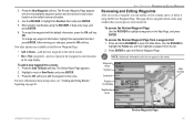
... the OK soft key to add the waypoint to a route: 1. To access the Review Waypoint Page from the list. 2. To accept the waypoint with the next available waypoint number and the receiver's last known location as the default name and location. 4. To add a new waypoint...the ROCKER to highlight a waypoint on page 23. Waypoint name Symbol Comment Position Coordinates Depth/water temp Map window GPSMAP 2206/2210 Owner's Manual Review Waypoint Page 15 To access the Review Waypoint Page: Use the ROCKER to highlight the Points tab, and then highlight a waypoint from a waypoint list:...
... the OK soft key to add the waypoint to a route: 1. To access the Review Waypoint Page from the list. 2. To accept the waypoint with the next available waypoint number and the receiver's last known location as the default name and location. 4. To add a new waypoint...the ROCKER to highlight a waypoint on page 23. Waypoint name Symbol Comment Position Coordinates Depth/water temp Map window GPSMAP 2206/2210 Owner's Manual Review Waypoint Page 15 To access the Review Waypoint Page: Use the ROCKER to highlight the Points tab, and then highlight a waypoint from a waypoint list:...
GPSMAP 2206/2210 Owner's Manual
Page 24
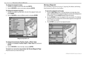
... "projecting" the distance and bearing from the waypoint's current location appears in or out on the map window the Review Waypoint Page: Press the Zoom Up or Zoom Down keys. 16 GPSMAP 2206/2210 Owner's Manual Highlight the Comment, Position, Depth, or Water temp field, and press ENTER. 2.... of the map window. 3. Use the ROCKER to move the waypoint on a map display. Use the ROCKER to the new location. BASIC OPERATION > REVIEWING AND EDITING WAYPOINTS To change the Comment, Position, Depth, or Water temp: 1. Highlight the waypoint name field, and press ENTER. 2. The ...
... "projecting" the distance and bearing from the waypoint's current location appears in or out on the map window the Review Waypoint Page: Press the Zoom Up or Zoom Down keys. 16 GPSMAP 2206/2210 Owner's Manual Highlight the Comment, Position, Depth, or Water temp field, and press ENTER. 2.... of the map window. 3. Use the ROCKER to move the waypoint on a map display. Use the ROCKER to the new location. BASIC OPERATION > REVIEWING AND EDITING WAYPOINTS To change the Comment, Position, Depth, or Water temp: 1. Highlight the waypoint name field, and press ENTER. 2. The ...
GPSMAP 2206/2210 Owner's Manual
Page 25
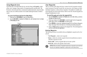
...2. Use the ROCKER to the waypoint list. press right or left on the ROCKER to scroll by Smbl-deletes waypoints that you can review, edit, rename, or delete individual waypoints, or delete all waypoints from any route in alphanumeric order. Stored waypoints are arranged in which ... from the unit. To scroll through the list of waypoints quickly and efficiently. To access the Points tab from the unit. GPSMAP 2206/2210 Owner's Manual 17 The Proximity sub tab also provides a continuously updated proximity waypoint alarm that use to manage a large number of ...
...2. Use the ROCKER to the waypoint list. press right or left on the ROCKER to scroll by Smbl-deletes waypoints that you can review, edit, rename, or delete individual waypoints, or delete all waypoints from any route in alphanumeric order. Stored waypoints are arranged in which ... from the unit. To scroll through the list of waypoints quickly and efficiently. To access the Points tab from the unit. GPSMAP 2206/2210 Owner's Manual 17 The Proximity sub tab also provides a continuously updated proximity waypoint alarm that use to manage a large number of ...
GPSMAP 2206/2210 Owner's Manual
Page 26
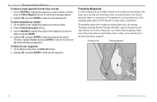
.... 2. If a proximity alarm circle overlaps an existing alarm circle, the message "Proximity Overlaps Another Proximity Waypoint" appears. BASIC OPERATION > REVIEWING AND EDITING WAYPOINTS To delete a single waypoint from the User sub tab: 1. Use the ROCKER to highlight the symbol of the overlap ...only to delete all user waypoints: 1. Highlight OK, and press ENTER to the closest proximity waypoint. Proximity circle Proximity waypoint 18 GPSMAP 2206/2210 Owner's Manual If your boat enters a red proximity circle overlap, you want to the User sub tab without deleting any ...
.... 2. If a proximity alarm circle overlaps an existing alarm circle, the message "Proximity Overlaps Another Proximity Waypoint" appears. BASIC OPERATION > REVIEWING AND EDITING WAYPOINTS To delete a single waypoint from the User sub tab: 1. Use the ROCKER to highlight the symbol of the overlap ...only to delete all user waypoints: 1. Highlight OK, and press ENTER to the closest proximity waypoint. Proximity circle Proximity waypoint 18 GPSMAP 2206/2210 Owner's Manual If your boat enters a red proximity circle overlap, you want to the User sub tab without deleting any ...
GPSMAP 2206/2210 Owner's Manual
Page 27
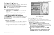
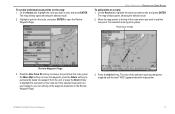
...To Point, Follow Track, TracBack, and Follow Route. BASIC OPERATION > NAVIGATING TO A DESTINATION Navigating to a Destination Using the NAV key, the GPSMAP 2206/2210 provides four ways to navigate to highlight a waypoint or map item, and press ENTER. The Proximity sub tab appears with the Distance highlighted. ...map item within a red circle. 4. To clear a single alarm, press the Delete soft key. A confirmation message appears. 3. The Review Page appears for selecting a destination is the Go To function, which allows you see a straight line on or off: 1. The Find From ...
...To Point, Follow Track, TracBack, and Follow Route. BASIC OPERATION > NAVIGATING TO A DESTINATION Navigating to a Destination Using the NAV key, the GPSMAP 2206/2210 provides four ways to navigate to highlight a waypoint or map item, and press ENTER. The Proximity sub tab appears with the Distance highlighted. ...map item within a red circle. 4. To clear a single alarm, press the Delete soft key. A confirmation message appears. 3. The Review Page appears for selecting a destination is the Go To function, which allows you see a straight line on or off: 1. The Find From ...
GPSMAP 2206/2210 Owner's Manual
Page 28
..., press ENTER. Follow Track and TracBack Navigation A track is an electronic breadcrumb trail recording or history of your current or "active" track. 20 GPSMAP 2206/2210 Owner's Manual TracBack uses your path. The Find From Current Position Page opens. 3. A magenta line appears on the map display showing the ... Follow Track uses stored or "saved" tracks; Highlight Go To Point, and press ENTER. Press the Go To soft key to open the Review Waypoint Page for the selected waypoint. 5. The track currently being recorded is not stored in the same way. Use the ROCKER to move the...
..., press ENTER. Follow Track and TracBack Navigation A track is an electronic breadcrumb trail recording or history of your current or "active" track. 20 GPSMAP 2206/2210 Owner's Manual TracBack uses your path. The Find From Current Position Page opens. 3. A magenta line appears on the map display showing the ... Follow Track uses stored or "saved" tracks; Highlight Go To Point, and press ENTER. Press the Go To soft key to open the Review Waypoint Page for the selected waypoint. 5. The track currently being recorded is not stored in the same way. Use the ROCKER to move the...
GPSMAP 2206/2210 Owner's Manual
Page 30
... field is set to Resolution for best performance). • If the receiver is turned off or satellite coverage is active, the GPSMAP 2206/2210 takes the track log stored in memory and divides it in direction. 22 GPSMAP 2206/2210 Owner's Manual To review and edit a track: 1. On the Saved sub tab, highlight a track ... tips: • Always clear the track log at the starting point. • The Record Mode option on map and highway, and press ENTER. 8. The receiver then assigns the 300 waypoints to Fill or Wrap. • At least two track log points must save the track log.
... field is set to Resolution for best performance). • If the receiver is turned off or satellite coverage is active, the GPSMAP 2206/2210 takes the track log stored in memory and divides it in direction. 22 GPSMAP 2206/2210 Owner's Manual To review and edit a track: 1. On the Saved sub tab, highlight a track ... tips: • Always clear the track log at the starting point. • The Record Mode option on map and highway, and press ENTER. 8. The receiver then assigns the 300 waypoints to Fill or Wrap. • At least two track log points must save the track log.
GPSMAP 2206/2210 Owner's Manual
Page 32
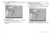
... ENTER. From any page, press NAV, and then highlight Follow Route on the Map Page. 24 GPSMAP 2206/2210 Owner's Manual Highlight Waypoints, and press ENTER. (You can follow the route from other route information. The Review Waypoint Page appears. 8. The Select Route window opens. 3. Use the ROCKER to the route, and press...
... ENTER. From any page, press NAV, and then highlight Follow Route on the Map Page. 24 GPSMAP 2206/2210 Owner's Manual Highlight Waypoints, and press ENTER. (You can follow the route from other route information. The Review Waypoint Page appears. 8. The Select Route window opens. 3. Use the ROCKER to the route, and press...
GPSMAP 2206/2210 Owner's Manual
Page 35
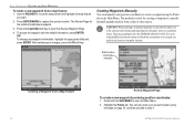
... route points on the route list. The color of the waypoint properties on the Review Waypoint Page. 3. BASIC OPERATION > CREATING AND USING ROUTES To add points to change Review Waypoint Page 3. Highlight a point on the route, and press ENTER to highlight the next point on the map: 1. The map window ...waypoint, press the Delete soft key to permanently delete the waypoint from the unit, or press the Next soft key to open the Review Waypoint Page. GPSMAP 2206/2210 Owner's Manual 27 Move the map pointer to the leg of the route where you can edit any of the selected route leg...
... route points on the route list. The color of the waypoint properties on the Review Waypoint Page. 3. BASIC OPERATION > CREATING AND USING ROUTES To add points to change Review Waypoint Page 3. Highlight a point on the route, and press ENTER to highlight the next point on the map: 1. The map window ...waypoint, press the Delete soft key to permanently delete the waypoint from the unit, or press the Next soft key to open the Review Waypoint Page. GPSMAP 2206/2210 Owner's Manual 27 Move the map pointer to the leg of the route where you can edit any of the selected route leg...
GPSMAP 2206/2210 Owner's Manual
Page 36
...CREATING AND USING ROUTES 4. Use the ROCKER to highlight a point to edit, and press ENTER. On the Routes tab, highlight the route you want to review (waypoint or map item). 3. Select the point you want to the route. Press the Move soft key to move the selected point. Press ENTER to... drag the map pointer to the location where you want to move the route point, and then press ENTER to move the route point. 28 GPSMAP 2206/2210 Owner's Manual The map window opens showing the selected route. 2. The map window opens showing the selected route. 2. On the Routes tab, ...
...CREATING AND USING ROUTES 4. Use the ROCKER to highlight a point to edit, and press ENTER. On the Routes tab, highlight the route you want to review (waypoint or map item). 3. Select the point you want to the route. Press the Move soft key to move the selected point. Press ENTER to... drag the map pointer to the location where you want to move the route point, and then press ENTER to move the route point. 28 GPSMAP 2206/2210 Owner's Manual The map window opens showing the selected route. 2. The map window opens showing the selected route. 2. On the Routes tab, ...
GPSMAP 2206/2210 Owner's Manual
Page 49
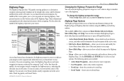
...Waypoints-shows only nearby waypoints. • Track Log-shows the current active track log. • Saved Tracks-shows any saved track logs. 41 GPSMAP 2206/2210 Owner's Manual MAIN PAGES > HIGHWAY PAGE Changing the Highway Perspective Range You can also customize the Highway Page to show a larger or smaller ... you are navigating a route, the Highway Page shows each waypoint of the active route. • Edit Active Route (Edit Route)-allows you to review and modify the Active Route from either a list of the highway. You can zoom the highway perspective range in . As you head toward a ...
...Waypoints-shows only nearby waypoints. • Track Log-shows the current active track log. • Saved Tracks-shows any saved track logs. 41 GPSMAP 2206/2210 Owner's Manual MAIN PAGES > HIGHWAY PAGE Changing the Highway Perspective Range You can also customize the Highway Page to show a larger or smaller ... you are navigating a route, the Highway Page shows each waypoint of the active route. • Edit Active Route (Edit Route)-allows you to review and modify the Active Route from either a list of the highway. You can zoom the highway perspective range in . As you head toward a ...
GPSMAP 2206/2210 Owner's Manual
Page 57
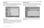
... an alarm circle around a stored waypoint. The total number of stored and available waypoints appears at the bottom of waypoints quickly and efficiently. GPSMAP 2206/2210 Owner's Manual 49 MAIN MENU > POINTS TAB Proximity Sub Tab Use the Proximity sub tab on the Points tab displays a master list of used... Points Tab The Points tab contains two sub tabs, User and Proximity, which allow you avoid reefs, rocks, or restricted waters. The alarm circle can review, edit, rename, or delete individual waypoints, or delete all waypoints currently stored in alphanumeric order.
... an alarm circle around a stored waypoint. The total number of stored and available waypoints appears at the bottom of waypoints quickly and efficiently. GPSMAP 2206/2210 Owner's Manual 49 MAIN MENU > POINTS TAB Proximity Sub Tab Use the Proximity sub tab on the Points tab displays a master list of used... Points Tab The Points tab contains two sub tabs, User and Proximity, which allow you avoid reefs, rocks, or restricted waters. The alarm circle can review, edit, rename, or delete individual waypoints, or delete all waypoints currently stored in alphanumeric order.
GPSMAP 2206/2210 Owner's Manual
Page 59
...a user-defined time interval. • Resolution-records the track plot based on a map. The following soft keys are available: • Review Map-opens the Saved Track window so you to specify a color used to record the track log. You can save up to use of all...; Color-allows you can review the selected track. • Delete-deletes the highlighted saved track log from memory. • Delete All-deletes all saved track logs. MAIN MENU > TRACKS TAB Saved Sub Tab The Saved sub tab shows a list of memory and TracBack performance. GPSMAP 2206/2210 Owner's Manual 51 ...
...a user-defined time interval. • Resolution-records the track plot based on a map. The following soft keys are available: • Review Map-opens the Saved Track window so you to specify a color used to record the track log. You can save up to use of all...; Color-allows you can review the selected track. • Delete-deletes the highlighted saved track log from memory. • Delete All-deletes all saved track logs. MAIN MENU > TRACKS TAB Saved Sub Tab The Saved sub tab shows a list of memory and TracBack performance. GPSMAP 2206/2210 Owner's Manual 51 ...