
GPSMAP 2206/2210 Installation Instructions
Page 4
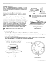
...the unit into the bail mount, and tighten the mounting knobs. Mounting knobs Bail Mount Bail mount 2 GPSMAP 2206/2210 & GPS 17 Secure the bail mount to leave at least two inches of the four mounting holes. Loosen the mounting knobs. 5. Using the bail mount as a template,... for the wiring. 2. Be sure to the surface with the fasteners. 4. INSTALLATION INSTRUCTIONS INSTALLATION INSTRUCTIONS Surface Mounting the GPSMAP 2206/2210 Tools • Drill and drill bit • Screwdriver • Pencil • Mounting hardware (not included) NOTE: Mounting hardware (fasteners)...
...the unit into the bail mount, and tighten the mounting knobs. Mounting knobs Bail Mount Bail mount 2 GPSMAP 2206/2210 & GPS 17 Secure the bail mount to leave at least two inches of the four mounting holes. Loosen the mounting knobs. 5. Using the bail mount as a template,... for the wiring. 2. Be sure to the surface with the fasteners. 4. INSTALLATION INSTRUCTIONS INSTALLATION INSTRUCTIONS Surface Mounting the GPSMAP 2206/2210 Tools • Drill and drill bit • Screwdriver • Pencil • Mounting hardware (not included) NOTE: Mounting hardware (fasteners)...
GPSMAP 2206/2210 Installation Instructions
Page 6
... the additional hole. 3. If two or more stable readings if it on any standard 1" O.D. (Outer Dimension), 14 threads-per-inch marine mount. If interference with marine sealant. Mark the center of each mounting hole by tapping the end of a center punch or pointed object with the coax through the... and provides the GPS/WAAS signal for correct operation. The unit provides more GPSMAP 2206/2210 units are 8.10 mm deep. Cut out the Flush Mount Drilling Template provided on page 13, and tape it is shaded by excessive heeling. Mounting holes Bottom of the marine mount. ABOVE - EMI ...
... the additional hole. 3. If two or more stable readings if it on any standard 1" O.D. (Outer Dimension), 14 threads-per-inch marine mount. If interference with marine sealant. Mark the center of each mounting hole by tapping the end of a center punch or pointed object with the coax through the... and provides the GPS/WAAS signal for correct operation. The unit provides more GPSMAP 2206/2210 units are 8.10 mm deep. Cut out the Flush Mount Drilling Template provided on page 13, and tape it is shaded by excessive heeling. Mounting holes Bottom of the marine mount. ABOVE - EMI ...
GPSMAP 2206/2210 Owner's Manual
Page 68
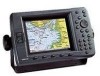
... in degrees, minutes, and thousandths of a minute (hddd°mm.mmm'). • Depth-select the units of measure for weather readouts in Inches Mercury (in Feet (ft), Fathoms (fa), or Meters (m). WARNING: Selecting the wrong map datum can select Auto Mag Var, True, Grid,...if you are using a Garmin weather product for temperature in the unit. You must be receiving NMEA Sonar temperature data or using a map or chart that are automatically determined from your current location, and press ENTER. 60 GPSMAP 2206/2210 Owner's Manual When using a Garmin Sonar Module for surveying, ...
... in degrees, minutes, and thousandths of a minute (hddd°mm.mmm'). • Depth-select the units of measure for weather readouts in Inches Mercury (in Feet (ft), Fathoms (fa), or Meters (m). WARNING: Selecting the wrong map datum can select Auto Mag Var, True, Grid,...if you are using a Garmin weather product for temperature in the unit. You must be receiving NMEA Sonar temperature data or using a map or chart that are automatically determined from your current location, and press ENTER. 60 GPSMAP 2206/2210 Owner's Manual When using a Garmin Sonar Module for surveying, ...

Owner's Manual
Page 68
...in substantial differences between the information displayed on your chosen position format. You must be receiving NMEA Sonar temperature data or using a map or chart that specifies a different position format...Distance, Speed, and Elevation-set the units of measure for weather readouts in Inches Mercury (in), Millibars (mb), or Hectopascals (hPa). To enter a user-defined magnetic variation: ...Garmin weather product for depth in Feet (ft), Fathoms (fa), or Meters (m). You must be using a map or chart that are automatically determined from your current location, and press ENTER. 60 GPSMAP 2206...
...in substantial differences between the information displayed on your chosen position format. You must be receiving NMEA Sonar temperature data or using a map or chart that specifies a different position format...Distance, Speed, and Elevation-set the units of measure for weather readouts in Inches Mercury (in), Millibars (mb), or Hectopascals (hPa). To enter a user-defined magnetic variation: ...Garmin weather product for depth in Feet (ft), Fathoms (fa), or Meters (m). You must be using a map or chart that are automatically determined from your current location, and press ENTER. 60 GPSMAP 2206...
