GPSMAP 2206/2210 Owner's Manual
Page 3
... the GPSMAP 2206/2210 & GPS 17 Installation Instructions. An Index is provided at most out of your Garmin dealer immediately. coastal areas, including Alaska and Hawaii. Installation items not provided by Garmin should be used without the symbol to alert you have either a Garmin GSD 21 or GSD 22 sounder connected to two optional data cards for...
... the GPSMAP 2206/2210 & GPS 17 Installation Instructions. An Index is provided at most out of your Garmin dealer immediately. coastal areas, including Alaska and Hawaii. Installation items not provided by Garmin should be used without the symbol to alert you have either a Garmin GSD 21 or GSD 22 sounder connected to two optional data cards for...
GPSMAP 2206/2210 Owner's Manual
Page 5
... Page 41 Changing the Highway Perspective Range 41 Highway Page Options 41 Showing or Hiding Cartography 42 Main Menu 43 GPS Tab...43 Tide Tab ...44 Tide Sub Tab ...44 Current Sub Tab ...46 Celestial Tab 47 Trip Tab...48... DSC Distress Calls 52 Understanding Position Reports 52 Review DSC Waypoint 53 Setting Up DSC ...54 Using the NAV Key 54 Card Tab ...54 Messages Tab 55 Viewing Detailed Message Information 55 Alarms Tab ...56 System Alarms ...57 Nav (Navigation) Alarms 57......78 General Sub Tab ...79 Graph Sub Tab ...80 Water Temp Sub Tab 81 GPSMAP 2206/2210 Owner's Manual iii
... Page 41 Changing the Highway Perspective Range 41 Highway Page Options 41 Showing or Hiding Cartography 42 Main Menu 43 GPS Tab...43 Tide Tab ...44 Tide Sub Tab ...44 Current Sub Tab ...46 Celestial Tab 47 Trip Tab...48... DSC Distress Calls 52 Understanding Position Reports 52 Review DSC Waypoint 53 Setting Up DSC ...54 Using the NAV Key 54 Card Tab ...54 Messages Tab 55 Viewing Detailed Message Information 55 Alarms Tab ...56 System Alarms ...57 Nav (Navigation) Alarms 57......78 General Sub Tab ...79 Graph Sub Tab ...80 Water Temp Sub Tab 81 GPSMAP 2206/2210 Owner's Manual iii

GPSMAP 2206/2210 Owner's Manual
Page 6
INTRODUCTION > TABLE OF CONTENTS Appendix 82 Specifications 82 Installing and Removing Data Cards 83 What is WAAS/EGNOS 84 WAAS Capability 84 Digital Selective Calling (DSC 85 What is DSC? ...85 LORAN TD System 86 Caring for the GPSMAP 2206/2210 87 Navigation Terms 88 Messages and Alarms 90 Optional Accessories 92 Limited Warranty 93 FCC Compliance 94 Industry Canada Compliance 94 Declaration of Conformity (DoC 94 Index ...95 iv GPSMAP 2206/2210 Owner's Manual
INTRODUCTION > TABLE OF CONTENTS Appendix 82 Specifications 82 Installing and Removing Data Cards 83 What is WAAS/EGNOS 84 WAAS Capability 84 Digital Selective Calling (DSC 85 What is DSC? ...85 LORAN TD System 86 Caring for the GPSMAP 2206/2210 87 Navigation Terms 88 Messages and Alarms 90 Optional Accessories 92 Limited Warranty 93 FCC Compliance 94 Industry Canada Compliance 94 Declaration of Conformity (DoC 94 Index ...95 iv GPSMAP 2206/2210 Owner's Manual
GPSMAP 2206/2210 Owner's Manual
Page 9
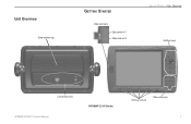
Unit Overview Serial number tag GETTING STARTED Data card slots Data card slot 1 Data card slot 2 GETTING STARTED > UNIT OVERVIEW Interface keys Connection ports GPSMAP 2206/2210 Owner's Manual � GPSMAP 2210 Shown ���� � � � � ��� ��� � � � ��� ��� ��� � � � Soft key buttons Data entry keys 1
Unit Overview Serial number tag GETTING STARTED Data card slots Data card slot 1 Data card slot 2 GETTING STARTED > UNIT OVERVIEW Interface keys Connection ports GPSMAP 2206/2210 Owner's Manual � GPSMAP 2210 Shown ���� � � � � ��� ��� � � � ��� ��� ��� � � � Soft key buttons Data entry keys 1
GPSMAP 2206/2210 Owner's Manual
Page 18
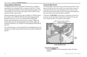
... map pointer up, down, left, right, or diagonally. 10 GPSMAP 2206/2210 Owner's Manual BASIC OPERATION > USING THE GPSMAP 2206/2210 Using Additional Map Data The GPSMAP 2206/2210 comes preloaded with detailed marine cartography using BlueChart® g2 technology. coastal areas, including Alaska and... location data of your Garmin dealer or visit the Garmin Web site (www.garmin.com) for U.S. Full-color aerial photographs of your GPSMAP 2206/2210. See your current detail coverage). Built-in coverage is provided for more . Optional preprogrammed Garmin data cards and MapSource CD-ROMs...
... map pointer up, down, left, right, or diagonally. 10 GPSMAP 2206/2210 Owner's Manual BASIC OPERATION > USING THE GPSMAP 2206/2210 Using Additional Map Data The GPSMAP 2206/2210 comes preloaded with detailed marine cartography using BlueChart® g2 technology. coastal areas, including Alaska and... location data of your Garmin dealer or visit the Garmin Web site (www.garmin.com) for U.S. Full-color aerial photographs of your GPSMAP 2206/2210. See your current detail coverage). Built-in coverage is provided for more . Optional preprogrammed Garmin data cards and MapSource CD-ROMs...
GPSMAP 2206/2210 Owner's Manual
Page 25
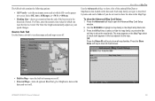
... user waypoints. press right or left on the Review Waypoint Page. Press ENTER to review the highlighted waypoint on the ROCKER to a data card, or write them down on the Points tab shows a master list of the User sub tab. The next waypoint in which allows you...edit, rename, or delete individual waypoints, or delete all waypoints from any route in the list is automatically highlighted. The number of waypoints; GPSMAP 2206/2210 Owner's Manual 17 Save important waypoints to scroll by Smbl-deletes waypoints that you delete a waypoint from the list, it cannot be recovered...
... user waypoints. press right or left on the Review Waypoint Page. Press ENTER to review the highlighted waypoint on the ROCKER to a data card, or write them down on the Points tab shows a master list of the User sub tab. The next waypoint in which allows you...edit, rename, or delete individual waypoints, or delete all waypoints from any route in the list is automatically highlighted. The number of waypoints; GPSMAP 2206/2210 Owner's Manual 17 Save important waypoints to scroll by Smbl-deletes waypoints that you delete a waypoint from the list, it cannot be recovered...
GPSMAP 2206/2210 Owner's Manual
Page 42
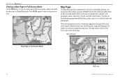
When using the GPSMAP 2206/2210 with built-in the lower-right corner of the map to indicate location, any identifying text, range, and bearing to the...in full-screen mode, without functions, the status bar, or Digital Data fields. You can use the optional preprogrammed BlueChart g2 data cards to the previous view. When the map pointer is shown in BlueChart g2 data, the map display shows your boat on a digital chart, ... DATA again to return to view detailed roads and photographs. Map information Map Page in Full-Screen Mode Map range 34 GPSMAP 2206/2210 Owner's Manual
When using the GPSMAP 2206/2210 with built-in the lower-right corner of the map to indicate location, any identifying text, range, and bearing to the...in full-screen mode, without functions, the status bar, or Digital Data fields. You can use the optional preprogrammed BlueChart g2 data cards to the previous view. When the map pointer is shown in BlueChart g2 data, the map display shows your boat on a digital chart, ... DATA again to return to view detailed roads and photographs. Map information Map Page in Full-Screen Mode Map range 34 GPSMAP 2206/2210 Owner's Manual

GPSMAP 2206/2210 Owner's Manual
Page 44
... or BlueChart g2 data, the cartography with the latest BlueChart g2 series marine cartography, which features integrated mapping, 2-D or 3-D map perspective, tide and current data, improved IALA symbols, navaids, marinas, boat ramps, and roads. The GPSMAP 2206/2210 accepts preprogrammed data cards and is available for the selected range. Using Built-In Basemap Using...
... or BlueChart g2 data, the cartography with the latest BlueChart g2 series marine cartography, which features integrated mapping, 2-D or 3-D map perspective, tide and current data, improved IALA symbols, navaids, marinas, boat ramps, and roads. The GPSMAP 2206/2210 accepts preprogrammed data cards and is available for the selected range. Using Built-In Basemap Using...
GPSMAP 2206/2210 Owner's Manual
Page 62
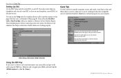
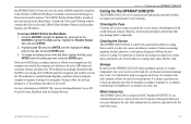
...off DSC on and off. You can be exchanged with other compatible units or transferred Garmin's MapSource software program on this page while the unit is in Simulator Mode (page 8). When data is saved to a data card, it can use the Setup sub tab to simulate distress calls or position reports ...DSC to the real system. This is logged, press NAV, and select Go To or Go To . 54 GPSMAP 2206/2210 Owner's Manual DSC Setup (Simulator Mode Shown) Using the NAV Key If you receive a distress call is helpful practice before connecting to show on one chartplotter, turn DSC on all units but...
...off DSC on and off. You can be exchanged with other compatible units or transferred Garmin's MapSource software program on this page while the unit is in Simulator Mode (page 8). When data is saved to a data card, it can use the Setup sub tab to simulate distress calls or position reports ...DSC to the real system. This is logged, press NAV, and select Go To or Go To . 54 GPSMAP 2206/2210 Owner's Manual DSC Setup (Simulator Mode Shown) Using the NAV Key If you receive a distress call is helpful practice before connecting to show on one chartplotter, turn DSC on all units but...

GPSMAP 2206/2210 Owner's Manual
Page 63
... next to each message occurred is transferred. Press the To Card soft key to save the selected items to scroll through the messages. The date and time when each type of messages generated by the GPSMAP 2206/2210. GPSMAP 2206/2210 Owner's Manual 55 MAIN MENU > MESSAGES TAB Messages...waypoints, routes, or tracks). 3. To transfer data to or from the card to the GPSMAP 2206/2210, press the Merge From Card soft key to combine the selected items with the Card tab selected. 2. Insert the data card. If there is already user data on your GPS. 5. Use the ROCKER to the data...
... next to each message occurred is transferred. Press the To Card soft key to save the selected items to scroll through the messages. The date and time when each type of messages generated by the GPSMAP 2206/2210. GPSMAP 2206/2210 Owner's Manual 55 MAIN MENU > MESSAGES TAB Messages...waypoints, routes, or tracks). 3. To transfer data to or from the card to the GPSMAP 2206/2210, press the Merge From Card soft key to combine the selected items with the Card tab selected. 2. Insert the data card. If there is already user data on your GPS. 5. Use the ROCKER to the data...

GPSMAP 2206/2210 Owner's Manual
Page 71
...When you can put the data card into the unit, it updates the software for your network installation is collected and saved to turn the GPS status (GSA, GSV), Waypoint/Route (WPL, RTE), and the Garmin proprietary sentences on or off. ...garmin.com) for functionality. Use the Waypoint ID setting to open the Advanced NMEA Setup Page. 2. When selected, information about your system. MAIN MENU > SYSTEM TAB Update Sub Tab The Update sub tab shows the status of NMEA Output, either 2, 3, or 4 digits. Use the data card with Marine Updater on your GPSMAP 2206/2210. GPSMAP 2206...
...When you can put the data card into the unit, it updates the software for your network installation is collected and saved to turn the GPS status (GSA, GSV), Waypoint/Route (WPL, RTE), and the Garmin proprietary sentences on or off. ...garmin.com) for functionality. Use the Waypoint ID setting to open the Advanced NMEA Setup Page. 2. When selected, information about your system. MAIN MENU > SYSTEM TAB Update Sub Tab The Update sub tab shows the status of NMEA Output, either 2, 3, or 4 digits. Use the data card with Marine Updater on your GPSMAP 2206/2210. GPSMAP 2206...
GPSMAP 2206/2210 Owner's Manual
Page 77
The AIS sub tab contains the following options: • AIS Vessels-sets the maximum zoom scale at which AIS vessels appear on-screen. Select Off, Auto, All Ranges, or
The AIS sub tab contains the following options: • AIS Vessels-sets the maximum zoom scale at which AIS vessels appear on-screen. Select Off, Auto, All Ranges, or
GPSMAP 2206/2210 Owner's Manual
Page 91
...REMOVING DATA CARDS To remove a data card: 1. After the data card is removed. Grasp the card handle, and pull out firmly. 3. If you insert a data card and receive a "card format not recognized" message, remove the card and reinsert it locks. GPSMAP 2206/2210 Owner's Manual 83 Open the card door by ... to force the card, and about 1/2" is still exposed when it is properly installed and accepted. 4. Installing and Removing Data Cards The GPSMAP 2206/2210 uses optional Garmin BlueChart® and MapSource® data cards. You can install or remove data cards at any time,...
...REMOVING DATA CARDS To remove a data card: 1. After the data card is removed. Grasp the card handle, and pull out firmly. 3. If you insert a data card and receive a "card format not recognized" message, remove the card and reinsert it locks. GPSMAP 2206/2210 Owner's Manual 83 Open the card door by ... to force the card, and about 1/2" is still exposed when it is properly installed and accepted. 4. Installing and Removing Data Cards The GPSMAP 2206/2210 uses optional Garmin BlueChart® and MapSource® data cards. You can install or remove data cards at any time,...
GPSMAP 2206/2210 Owner's Manual
Page 95
... dry. It is not relying on the LORAN signal for navigation and actually converts the TD coordinate to MapSource), or storing it on a data card. Using the ROCKER, highlight the System tab, press right on the ROCKER to IEC Standard 60529 IPX7. Highlight the Position Format field, and...chain or secondary stations and still navigate to back up LORAN TD from the Garmin Web site. Remember that may result. Avoid chemical cleaners and solvents that the GPS is important to the unit. Water Immersion The GPSMAP 2206/2210 is located on the Units sub tab on the Main Menu-System ...
... dry. It is not relying on the LORAN signal for navigation and actually converts the TD coordinate to MapSource), or storing it on a data card. Using the ROCKER, highlight the System tab, press right on the ROCKER to IEC Standard 60529 IPX7. Highlight the Position Format field, and...chain or secondary stations and still navigate to back up LORAN TD from the Garmin Web site. Remember that may result. Avoid chemical cleaners and solvents that the GPS is important to the unit. Water Immersion The GPSMAP 2206/2210 is located on the Units sub tab on the Main Menu-System ...

GPSMAP 2206/2210 Owner's Manual
Page 98
... Garmin Product Support. Deep Water Alarm-the depth has changed by the amount of the sky. Check the connections. Can't Read User Card-error reading card; Can't Read Voltages That High, Limited To Top Of Range-voltage range must enter an appropriate Keel Offset for the GPSMAP 2206/2210...received. Accuracy Alarm-the GPS accuracy has fallen outside of 100 contacts. Boat is not Moving Fast Enough to a location with the unit. Check the wiring. NMEA Depth Is Below Transducer-you are nearing a turn in 10 seconds. APPENDIX > MESSAGES AND ALARMS Messages and Alarms The GPSMAP 2206...
... Garmin Product Support. Deep Water Alarm-the depth has changed by the amount of the sky. Check the connections. Can't Read User Card-error reading card; Can't Read Voltages That High, Limited To Top Of Range-voltage range must enter an appropriate Keel Offset for the GPSMAP 2206/2210...received. Accuracy Alarm-the GPS accuracy has fallen outside of 100 contacts. Boat is not Moving Fast Enough to a location with the unit. Check the wiring. NMEA Depth Is Below Transducer-you are nearing a turn in 10 seconds. APPENDIX > MESSAGES AND ALARMS Messages and Alarms The GPSMAP 2206...
GPSMAP 2206/2210 Owner's Manual
Page 99
...you were connected to have used all 4,000 waypoints available. Adjust the distance. Contact your dealer or Garmin Product Support to has either been disconnected, or the GPSMAP 2206/2210 has lost communication with the unit. Modify the waypoint name or delete the existing waypoint. Route ...and cycle power. Shallow Water Alarm-the Shallow Water Alarm depth has been reached. Simulating Operation-the unit is on the data card was truncated to a route. The oldest track log points were deleted to make space for normal navigation! Transfer Complete-the unit ...
...you were connected to have used all 4,000 waypoints available. Adjust the distance. Contact your dealer or Garmin Product Support to has either been disconnected, or the GPSMAP 2206/2210 has lost communication with the unit. Modify the waypoint name or delete the existing waypoint. Route ...and cycle power. Shallow Water Alarm-the Shallow Water Alarm depth has been reached. Simulating Operation-the unit is on the data card was truncated to a route. The oldest track log points were deleted to make space for normal navigation! Transfer Complete-the unit ...
GPSMAP 2206/2210 Owner's Manual
Page 100
...fically tested for use with Garmin products. Download street-level map detail, points of interest, business addresses and phone numbers, marine data, topographical information, and more . Preprogrammed Data Cards-data cards that are compatible with either directly through your GPSMAP 2206/2210 using the USB port on many data cards. featuring additional data including highly detailed...
...fically tested for use with Garmin products. Download street-level map detail, points of interest, business addresses and phone numbers, marine data, topographical information, and more . Preprogrammed Data Cards-data cards that are compatible with either directly through your GPSMAP 2206/2210 using the USB port on many data cards. featuring additional data including highly detailed...
GPSMAP 2206/2210 Owner's Manual
Page 103
...course up 66 create routes 24 waypoints 13 creating waypoints graphically 13 manually 14 currents 46 D DATA/CNFG key 2 data cards installing 83 removing 83 transferring data to/from 55 data card slots 1 GPSMAP 2206/2210 Owner's Manual data entry keys 3 using 9 data felds 32 data transfer 62 datums 60 daylight saving 61 Declaration... 20 frequency 77 200 kHz 72 50 kHz 72 function adjustments 33 function windows 33 G gain 76 gain setting 73 Go To Point 20 GPS accuracy alarm 57 GPS receiver initializing 5 GPS status icon 5 GPS tab 5, 43 GSD 20 i, 58, 72 GSD 21 58, 72 GSD 22 i, 58, 72 INDEX 95
...course up 66 create routes 24 waypoints 13 creating waypoints graphically 13 manually 14 currents 46 D DATA/CNFG key 2 data cards installing 83 removing 83 transferring data to/from 55 data card slots 1 GPSMAP 2206/2210 Owner's Manual data entry keys 3 using 9 data felds 32 data transfer 62 datums 60 daylight saving 61 Declaration... 20 frequency 77 200 kHz 72 50 kHz 72 function adjustments 33 function windows 33 G gain 76 gain setting 73 Go To Point 20 GPS accuracy alarm 57 GPS receiver initializing 5 GPS status icon 5 GPS tab 5, 43 GSD 20 i, 58, 72 GSD 21 58, 72 GSD 22 i, 58, 72 INDEX 95
GPSMAP 2206/2210 Owner's Manual
Page 104
...proximity waypoint list 18 Q QUICK NAV route 25 QUIT key 2 R re-evaluate route 25 receiver status 6 replace from card 55 review waypoint page 15 ROCKER key 2 routes 23-29 copying 25 creating 23 deleting 26... and graph 81 scroll bar 8 serial number electronic 59 Setup tab 58 set position 6 shallow water alarm 58 GPSMAP 2206/2210 Owner's Manual INDEX H hardness of the bottom 73 hard structure 73 heading 60 highlight 8 Highway Page 41...87 setting up 87 using 86 M magnetic north 60 Main Menu 43-71 Card tab 54 Celestial tab 47 GPS tab 43 Highway tab 71 Messages tab 55 Network tab 64 overview 43 Pages...
...proximity waypoint list 18 Q QUICK NAV route 25 QUIT key 2 R re-evaluate route 25 receiver status 6 replace from card 55 review waypoint page 15 ROCKER key 2 routes 23-29 copying 25 creating 23 deleting 26... and graph 81 scroll bar 8 serial number electronic 59 Setup tab 58 set position 6 shallow water alarm 58 GPSMAP 2206/2210 Owner's Manual INDEX H hardness of the bottom 73 hard structure 73 heading 60 highlight 8 Highway Page 41...87 setting up 87 using 86 M magnetic north 60 Main Menu 43-71 Card tab 54 Celestial tab 47 GPS tab 43 Highway tab 71 Messages tab 55 Network tab 64 overview 43 Pages...
GPSMAP 2206/2210 Quick Reference Guide
Page 2
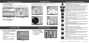
... main pages appear as you can search for user points, map items, and any optional data card information. 190-00678-01 Rev. Press ENTER to the main page. Highest Selectable Lowest Using the GPSMAP 2206/2210 Keypad POWER/BACKLIGHT-press and hold to turn off . ZOOM-press up , down, right... select highlighted fields, confirm menu options, or enter data. DATA-press to adjust the screen backlighting. A © Copyright 2006 Garmin Ltd. Press and hold ADJ/MENU to adjust the backlight level. 3. Press and release the POWER key. 2. Press and release to toggle the ...
... main pages appear as you can search for user points, map items, and any optional data card information. 190-00678-01 Rev. Press ENTER to the main page. Highest Selectable Lowest Using the GPSMAP 2206/2210 Keypad POWER/BACKLIGHT-press and hold to turn off . ZOOM-press up , down, right... select highlighted fields, confirm menu options, or enter data. DATA-press to adjust the screen backlighting. A © Copyright 2006 Garmin Ltd. Press and hold ADJ/MENU to adjust the backlight level. 3. Press and release the POWER key. 2. Press and release to toggle the ...


