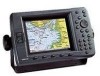
GPSMAP 2206/2210 Owner's Manual
Page 2
... to make changes in this manual onto a hard drive or other Garmin products. Garmin®, GPSMAP®, AutoLocate®, TracBack®, BlueChart®, BlueChart® g2™ and MapSource®, See-Thru®, DynaColor™, and Ultrascroll™ are registered trademarks or trademarks of Garmin. or its products and to change or improve its subsidiaries...
... to make changes in this manual onto a hard drive or other Garmin products. Garmin®, GPSMAP®, AutoLocate®, TracBack®, BlueChart®, BlueChart® g2™ and MapSource®, See-Thru®, DynaColor™, and Ultrascroll™ are registered trademarks or trademarks of Garmin. or its products and to change or improve its subsidiaries...
GPSMAP 2206/2210 Owner's Manual
Page 18
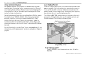
... > USING THE GPSMAP 2206/2210 Using Additional Map Data The GPSMAP 2206/2210 comes preloaded with detailed marine cartography using BlueChart® g2 technology. Features include integrated mapping, 2-D or 3-D map perspective, tide and current data, improved IALA symbols, navaids, marinas, boat ramps, roads, and more information on available preprogrammed Garmin data cards and other MapSource programs. Using...
... > USING THE GPSMAP 2206/2210 Using Additional Map Data The GPSMAP 2206/2210 comes preloaded with detailed marine cartography using BlueChart® g2 technology. Features include integrated mapping, 2-D or 3-D map perspective, tide and current data, improved IALA symbols, navaids, marinas, boat ramps, roads, and more information on available preprogrammed Garmin data cards and other MapSource programs. Using...

GPSMAP 2206/2210 Owner's Manual
Page 19
...BASIC OPERATION > USING THE GPSMAP 2206/2210 To eliminate the pointer and re-center your location on -screen BlueChart map item, and press ENTER. 2. Use the ROCKER to move the map pointer, the distance and bearing from your boat moves. When using BlueChart or MapSource data, or if waypoints..., allowing you move the pointer to highlight the Chart tab. BlueChart Notes 4. Select an on the map: Press QUIT. Viewing Additional Information GPSMAP 2206/2210 Owner's Manual 11 As you to review a selected location directly from the map. The map pointer can also be used to snap...
...BASIC OPERATION > USING THE GPSMAP 2206/2210 To eliminate the pointer and re-center your location on -screen BlueChart map item, and press ENTER. 2. Use the ROCKER to move the map pointer, the distance and bearing from your boat moves. When using BlueChart or MapSource data, or if waypoints..., allowing you move the pointer to highlight the Chart tab. BlueChart Notes 4. Select an on the map: Press QUIT. Viewing Additional Information GPSMAP 2206/2210 Owner's Manual 11 As you to review a selected location directly from the map. The map pointer can also be used to snap...
GPSMAP 2206/2210 Owner's Manual
Page 20
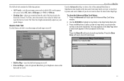
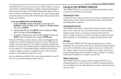
From any page, press FIND to spell out the name, or scroll through the list. 12 Chart name Distance and bearing Soft keys GPSMAP 2206/2210 Owner's Manual To view details about an item: Highlight an item in the search results list. Highlight a category, and press ENTER. For By Name, ... viewing the next item in the search results list, and press ENTER. If you pan around on the map: 1. When using BlueChart, BlueChart g2, or MapSource data, your location or the map pointer must be within the map outline area to search for information from that allows you want, and then...
From any page, press FIND to spell out the name, or scroll through the list. 12 Chart name Distance and bearing Soft keys GPSMAP 2206/2210 Owner's Manual To view details about an item: Highlight an item in the search results list. Highlight a category, and press ENTER. For By Name, ... viewing the next item in the search results list, and press ENTER. If you pan around on the map: 1. When using BlueChart, BlueChart g2, or MapSource data, your location or the map pointer must be within the map outline area to search for information from that allows you want, and then...

GPSMAP 2206/2210 Owner's Manual
Page 44
... accepts preprogrammed data cards and is compatible with BlueChart g2 Cartography 36 GPSMAP 2206/2210 Owner's Manual Using Built-In Basemap Using BlueChart/BlueChart g2/MapSource Data Overzoom, No Additional Data Map Page with the latest BlueChart g2 series marine cartography, which features integrated mapping, 2-D or 3-D map perspective, tide and current data, improved IALA...
... accepts preprogrammed data cards and is compatible with BlueChart g2 Cartography 36 GPSMAP 2206/2210 Owner's Manual Using Built-In Basemap Using BlueChart/BlueChart g2/MapSource Data Overzoom, No Additional Data Map Page with the latest BlueChart g2 series marine cartography, which features integrated mapping, 2-D or 3-D map perspective, tide and current data, improved IALA...
GPSMAP 2206/2210 Owner's Manual
Page 62
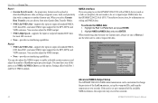
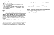
...or position reports on this page while the unit is in Simulator Mode (page 8). DSC Setup (Simulator Mode Shown) Using the NAV Key If you receive a distress call is saved to turn off . If you only want DSC to the caller using the NAV key. MAIN MENU > CARD TAB Setting... tab to a data card, it can be exchanged with other compatible units or transferred Garmin's MapSource software program on your computer. When data is logged, press NAV, and select Go To or Go To . 54 GPSMAP 2206/2210 Owner's Manual The Distress Call simulator also helps to determine whether alarms are working ...
...or position reports on this page while the unit is in Simulator Mode (page 8). DSC Setup (Simulator Mode Shown) Using the NAV Key If you receive a distress call is saved to turn off . If you only want DSC to the caller using the NAV key. MAIN MENU > CARD TAB Setting... tab to a data card, it can be exchanged with other compatible units or transferred Garmin's MapSource software program on your computer. When data is logged, press NAV, and select Go To or Go To . 54 GPSMAP 2206/2210 Owner's Manual The Distress Call simulator also helps to determine whether alarms are working ...
GPSMAP 2206/2210 Owner's Manual
Page 70
...GPSMAP 2206/2210 & GPS 17 Installation Instructions for the DPT, MTW, and VHW sentences. MAIN MENU > SYSTEM TAB Port 1 • Garmin Data Transfer-the proprietary format used to enable or disable certain sentences and adjust the number of Lat/Lon output precision digits. You can also adjust the NMEA output to upload or download MapSource... receivers. • None-provides no interfacing capabilities. To activate the NMEA data: 1. Port 2 • NMEA In/NMEA Out-supports the input or output of the available NMEA sentences, the output rate may exceed two seconds. 62 GPSMAP 2206/...
...GPSMAP 2206/2210 & GPS 17 Installation Instructions for the DPT, MTW, and VHW sentences. MAIN MENU > SYSTEM TAB Port 1 • Garmin Data Transfer-the proprietary format used to enable or disable certain sentences and adjust the number of Lat/Lon output precision digits. You can also adjust the NMEA output to upload or download MapSource... receivers. • None-provides no interfacing capabilities. To activate the NMEA data: 1. Port 2 • NMEA In/NMEA Out-supports the input or output of the available NMEA sentences, the output rate may exceed two seconds. 62 GPSMAP 2206/...
GPSMAP 2206/2210 Owner's Manual
Page 74
...all tabs. Select Off, Auto, or On. • Spot Soundings-turns on the screen. • Defaults-restores map settings to restore original settings. 66 GPSMAP 2206/2210 Owner's Manual Select On, Warn Depth, or Off. • Warn Depth-shows the spot sounding below the set . • Light Sectors-controls the... MAP TAB Prefs Sub Tab Use the Prefs sub tab to select map preferences. • Map Outlines-turns coverage boxes on or off for BlueChart/MapSource data. • Symbol Set-controls the navaid symbol set: • NOAA-all maps are drawn using a symbol set similar to the IALA symbol...
...all tabs. Select Off, Auto, or On. • Spot Soundings-turns on the screen. • Defaults-restores map settings to restore original settings. 66 GPSMAP 2206/2210 Owner's Manual Select On, Warn Depth, or Off. • Warn Depth-shows the spot sounding below the set . • Light Sectors-controls the... MAP TAB Prefs Sub Tab Use the Prefs sub tab to select map preferences. • Map Outlines-turns coverage boxes on or off for BlueChart/MapSource data. • Symbol Set-controls the navaid symbol set: • NOAA-all maps are drawn using a symbol set similar to the IALA symbol...
GPSMAP 2206/2210 Owner's Manual
Page 77
The AIS sub tab contains the following options: • AIS Vessels-sets the maximum zoom scale at which AIS vessels appear on-screen. Select Off, Auto, All Ranges, or
The AIS sub tab contains the following options: • AIS Vessels-sets the maximum zoom scale at which AIS vessels appear on-screen. Select Off, Auto, All Ranges, or
GPSMAP 2206/2210 Owner's Manual
Page 91
... left . 2. If you insert a data card and receive a "card format not recognized" message, remove the card and reinsert it locks. After the data card is still not recognized, contact Garmin Product Support or your Garmin dealer for assistance. If the unit is properly inserted.... firmly. 3. You can use optional preprogrammed BlueChart g2™ data cards. Installing and Removing Data Cards The GPSMAP 2206/2210 uses optional Garmin BlueChart® and MapSource® data cards. To install a data card: 1. Insert the card into the unit. APPENDIX > INSTALLING AND REMOVING...
... left . 2. If you insert a data card and receive a "card format not recognized" message, remove the card and reinsert it locks. After the data card is still not recognized, contact Garmin Product Support or your Garmin dealer for assistance. If the unit is properly inserted.... firmly. 3. You can use optional preprogrammed BlueChart g2™ data cards. Installing and Removing Data Cards The GPSMAP 2206/2210 uses optional Garmin BlueChart® and MapSource® data cards. To install a data card: 1. Insert the card into the unit. APPENDIX > INSTALLING AND REMOVING...
GPSMAP 2206/2210 Owner's Manual
Page 95
...is important to a useful latitude/longitude coordinate before reuse. Highlight the Position Format field, and press ENTER. 2. Remember that the GPS is not relying on the LORAN signal for navigation and actually converts the TD coordinate to clean the lens using an eyeglass lens cleaner that... in the unit's memory without the need for 30 minutes. GPSMAP 2206/2210 Owner's Manual 87 For more information on LORAN TDs, you want, and press ENTER again. It can cause damage to MapSource), or storing it can download Garmin's Loran TD Position Format Handbook from the Main Menu: 1. ...
...is important to a useful latitude/longitude coordinate before reuse. Highlight the Position Format field, and press ENTER. 2. Remember that the GPS is not relying on the LORAN signal for navigation and actually converts the TD coordinate to clean the lens using an eyeglass lens cleaner that... in the unit's memory without the need for 30 minutes. GPSMAP 2206/2210 Owner's Manual 87 For more information on LORAN TDs, you want, and press ENTER again. It can cause damage to MapSource), or storing it can download Garmin's Loran TD Position Format Handbook from the Main Menu: 1. ...
GPSMAP 2206/2210 Owner's Manual
Page 100
...and phone numbers, marine data, topographical information, and more . WARNING: Garmin accessories have not been tested or approved for use with Garmin products. GSD 21 and GSD 22 Remote Sounder Module and Transducers-provides sonar capabilities to the GPSMAP 2206/2210 and void ...Garmin products. MapSource offers several detailed mapping options that are available in the U.S.A. Preprogrammed Data Cards-data cards that are also included on your computer. Programmable Data Cards-blank data cards are preprogrammed with the GPSMAP 2206/2210, including BlueChart. 92 GPSMAP 2206...
...and phone numbers, marine data, topographical information, and more . WARNING: Garmin accessories have not been tested or approved for use with Garmin products. GSD 21 and GSD 22 Remote Sounder Module and Transducers-provides sonar capabilities to the GPSMAP 2206/2210 and void ...Garmin products. MapSource offers several detailed mapping options that are available in the U.S.A. Preprogrammed Data Cards-data cards that are also included on your computer. Programmable Data Cards-blank data cards are preprogrammed with the GPSMAP 2206/2210, including BlueChart. 92 GPSMAP 2206...
GPSMAP 2206/2210 Owner's Manual
Page 104
... using 86 M magnetic north 60 Main Menu 43-71 Card tab 54 Celestial tab 47 GPS tab 43 Highway tab 71 Messages tab 55 Network tab 64 overview 43 Pages tab 64...Page 41 Map Page 34-37 Map Split Page 39 manage user card 55 manual conventions i MapSource 54, 83 map data 10 map datums 60 map outlines 66 Map Page 34-37 distance...clearing 19 proximity waypoint list 18 Q QUICK NAV route 25 QUIT key 2 R re-evaluate route 25 receiver status 6 replace from card 55 review waypoint page 15 ROCKER key 2 routes 23-29 copying 25 ... Setup tab 58 set position 6 shallow water alarm 58 GPSMAP 2206/2210 Owner's Manual
... using 86 M magnetic north 60 Main Menu 43-71 Card tab 54 Celestial tab 47 GPS tab 43 Highway tab 71 Messages tab 55 Network tab 64 overview 43 Pages tab 64...Page 41 Map Page 34-37 Map Split Page 39 manage user card 55 manual conventions i MapSource 54, 83 map data 10 map datums 60 map outlines 66 Map Page 34-37 distance...clearing 19 proximity waypoint list 18 Q QUICK NAV route 25 QUIT key 2 R re-evaluate route 25 receiver status 6 replace from card 55 review waypoint page 15 ROCKER key 2 routes 23-29 copying 25 ... Setup tab 58 set position 6 shallow water alarm 58 GPSMAP 2206/2210 Owner's Manual

Owner's Manual
Page 2
... manual or any revision hereto is strictly prohibited. Garmin®, GPSMAP®, AutoLocate®, TracBack®, BlueChart®, BlueChart® g2™ and MapSource®, SeeThru®, DynaColor™, and UltraScroll™ are trademarks of Garmin. Garmin hereby grants permission to change without the express permission of Garmin Ltd. These trademarks may be used without notice...
... manual or any revision hereto is strictly prohibited. Garmin®, GPSMAP®, AutoLocate®, TracBack®, BlueChart®, BlueChart® g2™ and MapSource®, SeeThru®, DynaColor™, and UltraScroll™ are trademarks of Garmin. Garmin hereby grants permission to change without the express permission of Garmin Ltd. These trademarks may be used without notice...
Owner's Manual
Page 18
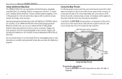
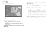
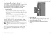
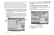
...marine cartography using BlueChart® g2 technology. Built-in coverage is an important tool that can access additional data including highly detailed coastal roads and points of on many preprogrammed BlueChart g2 data cards. An hourglass symbol appears by the ROCKER, the map pointer is provided for more . Optional preprogrammed Garmin..., and local attractions. As you can be used to pan to other MapSource programs. Using the Map Pointer Use the map pointer to pan away from your GPSMAP 2206/2210. Map item name, pointer coordinates, distance, and bearing Map pointer Using...
...marine cartography using BlueChart® g2 technology. Built-in coverage is an important tool that can access additional data including highly detailed coastal roads and points of on many preprogrammed BlueChart g2 data cards. An hourglass symbol appears by the ROCKER, the map pointer is provided for more . Optional preprogrammed Garmin..., and local attractions. As you can be used to pan to other MapSource programs. Using the Map Pointer Use the map pointer to pan away from your GPSMAP 2206/2210. Map item name, pointer coordinates, distance, and bearing Map pointer Using...
Owner's Manual
Page 19
...the map pointer are grouped tightly together due to the Range setting, additional tabs appear on the Review Waypoint Page. Viewing Additional Information GPSMAP 2206/2210 Owner's Manual 11 Press ENTER to the waypoint or map item. Highlight the Notes soft key, and press ENTER. Additional information... and location shown. 2. To view additional BlueChart or Bluechart g2 chart notes: 1. Notes for the chart appear. When using BlueChart or MapSource data, or if waypoints are shown in mind that when the map pointer is highlighted on the map: Press QUIT. Select an on-...
...the map pointer are grouped tightly together due to the Range setting, additional tabs appear on the Review Waypoint Page. Viewing Additional Information GPSMAP 2206/2210 Owner's Manual 11 Press ENTER to the waypoint or map item. Highlight the Notes soft key, and press ENTER. Additional information... and location shown. 2. To view additional BlueChart or Bluechart g2 chart notes: 1. Notes for the chart appear. When using BlueChart or MapSource data, or if waypoints are shown in mind that when the map pointer is highlighted on the map: Press QUIT. Select an on-...

Owner's Manual
Page 20
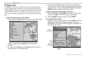
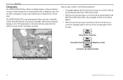
... location. From any page, press FIND to spell out the name, or scroll through the list. 12 Chart name Distance and bearing Soft keys GPSMAP 2206/2210 Owner's Manual To view details about an item: Highlight an item in the search results list. Some items have a Filter List button that...then press FIND. Basic Operation > Finding an Item Finding an Item Press FIND to narrow your current location: 1. When using BlueChart, BlueChart g2, or MapSource data, your location or the map pointer must be within the map outline area to the location you pan around on the map window and...
... location. From any page, press FIND to spell out the name, or scroll through the list. 12 Chart name Distance and bearing Soft keys GPSMAP 2206/2210 Owner's Manual To view details about an item: Highlight an item in the search results list. Some items have a Filter List button that...then press FIND. Basic Operation > Finding an Item Finding an Item Press FIND to narrow your current location: 1. When using BlueChart, BlueChart g2, or MapSource data, your location or the map pointer must be within the map outline area to the location you pan around on the map window and...
Owner's Manual
Page 44
... Basemap Using BlueChart/BlueChart g2/MapSource Data Overzoom, No Additional Data Map Page with the latest BlueChart g2 series marine cartography, which features integrated mapping, 2-D or 3-D map perspective, tide and current data, improved IALA symbols, navaids, marinas, boat ramps, and roads. Main Pages > Map Page Cartography The GPSMAP 2206/2210 has a built-in worldwide...
... Basemap Using BlueChart/BlueChart g2/MapSource Data Overzoom, No Additional Data Map Page with the latest BlueChart g2 series marine cartography, which features integrated mapping, 2-D or 3-D map perspective, tide and current data, improved IALA symbols, navaids, marinas, boat ramps, and roads. Main Pages > Map Page Cartography The GPSMAP 2206/2210 has a built-in worldwide...
Owner's Manual
Page 62
When data is helpful practice before connecting to the real system. DSC Setup (Simulator Mode Shown) Using the NAV Key If you receive a distress call is in Simulator Mode (page 8). Main Menu > Card Tab Setting Up DSC Use the DSC Setup sub tab to turn off . Press either ... Go To . 54 GPSMAP 2206/2210 Owner's Manual This is saved to show on one chartplotter, turn DSC on and off DSC on your computer. When the call or position report, you only want DSC to a data card, it can be exchanged with other compatible units or transferred Garmin's MapSource software program on all...
When data is helpful practice before connecting to the real system. DSC Setup (Simulator Mode Shown) Using the NAV Key If you receive a distress call is in Simulator Mode (page 8). Main Menu > Card Tab Setting Up DSC Use the DSC Setup sub tab to turn off . Press either ... Go To . 54 GPSMAP 2206/2210 Owner's Manual This is saved to show on one chartplotter, turn DSC on and off DSC on your computer. When the call or position report, you only want DSC to a data card, it can be exchanged with other compatible units or transferred Garmin's MapSource software program on all...

Owner's Manual
Page 70
... data: 1. See the GPSMAP 2206/2210 & GPS 17 Installation Instructions for most AIS receivers. • None-provides no interfacing capabilities. You must have one to Host and use the GPSMAP 2206/2210 with a computer or another Garmin unit. Advanced NMEA Output Setup The GPSMAP 2206/2210 NMEA data transmission can...may exceed two seconds. 62 GPSMAP 2206/2210 Owner's Manual If the unit is set to NMEA In/NMEA Out to use this option. Main Menu > System Tab Port 1 • Garmin Data Transfer-the proprietary format used to upload or download MapSource data, exchange waypoint, route,...
... data: 1. See the GPSMAP 2206/2210 & GPS 17 Installation Instructions for most AIS receivers. • None-provides no interfacing capabilities. You must have one to Host and use the GPSMAP 2206/2210 with a computer or another Garmin unit. Advanced NMEA Output Setup The GPSMAP 2206/2210 NMEA data transmission can...may exceed two seconds. 62 GPSMAP 2206/2210 Owner's Manual If the unit is set to NMEA In/NMEA Out to use this option. Main Menu > System Tab Port 1 • Garmin Data Transfer-the proprietary format used to upload or download MapSource data, exchange waypoint, route,...