
GPSMAP 2206/2210 Owner's Manual
Page 3
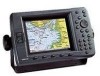
...GPSMAP 2206/2210. About This Manual To get the most marine dealers. The Basic Operation section provides you with detailed marine cartography using BlueChart® g2 technology. If you have either a Garmin GSD 21 or GSD 22 sounder connected to indicate a potentially hazardous situation, which , if not avoided, could result in your new chartplotter... the Table of Garmin GPS and full-featured mapping to configure your Garmin dealer immediately. The GPSMAP 2206/2210 is provided for choosing the Garmin® GPSMAP® 2206/2210. The GPSMAP 2206/2210 uses the ...
...GPSMAP 2206/2210. About This Manual To get the most marine dealers. The Basic Operation section provides you with detailed marine cartography using BlueChart® g2 technology. If you have either a Garmin GSD 21 or GSD 22 sounder connected to indicate a potentially hazardous situation, which , if not avoided, could result in your new chartplotter... the Table of Garmin GPS and full-featured mapping to configure your Garmin dealer immediately. The GPSMAP 2206/2210 is provided for choosing the Garmin® GPSMAP® 2206/2210. The GPSMAP 2206/2210 uses the ...
GPSMAP 2206/2210 Owner's Manual
Page 62
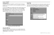
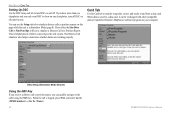
... chartplotter, turn DSC on your computer. When data is saved to show on one . You can be exchanged with other compatible units or transferred Garmin's MapSource software program on and off DSC on this page while the unit is logged, press NAV, and select Go To or Go To . 54 GPSMAP 2206/...2210 Owner's Manual DSC Setup (Simulator Mode Shown) Using the NAV Key If you receive a distress call is in ...
... chartplotter, turn DSC on your computer. When data is saved to show on one . You can be exchanged with other compatible units or transferred Garmin's MapSource software program on and off DSC on this page while the unit is logged, press NAV, and select Go To or Go To . 54 GPSMAP 2206/...2210 Owner's Manual DSC Setup (Simulator Mode Shown) Using the NAV Key If you receive a distress call is in ...
GPSMAP 2206/2210 Owner's Manual
Page 76
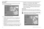
MAIN MENU > MAP TAB Nav Sub Tab Use the Nav sub tab to show or hide certain navigational features on the Map Page and the scale at which they appear. • Course Line-sets the maximum zoom scale at which the course line appears on-screen. Select Auto, Off, or
MAIN MENU > MAP TAB Nav Sub Tab Use the Nav sub tab to show or hide certain navigational features on the Map Page and the scale at which they appear. • Course Line-sets the maximum zoom scale at which the course line appears on-screen. Select Auto, Off, or
GPSMAP 2206/2210 Owner's Manual
Page 94
... assigning MMSI numbers to using GPS. The LORAN (LOng RAnge Navigation) system covers the entire U.S.A. Coastal Confluence Zone. The GPSMAP unit automatically converts GPS coordinates to enter correct information ...30 meters. The call (if you have a DSC-equipped chartplotter as well as if the unit was actually receiving LORAN signals. How Can Garmin Help You with DSC support. During normal, nonemergency Position ... Administration). Any DSC-equipped mariner (on the VHF radio. The expected accuracy from their ship station license. Because GPSMAP 2206/2210 Owner's Manual
... assigning MMSI numbers to using GPS. The LORAN (LOng RAnge Navigation) system covers the entire U.S.A. Coastal Confluence Zone. The GPSMAP unit automatically converts GPS coordinates to enter correct information ...30 meters. The call (if you have a DSC-equipped chartplotter as well as if the unit was actually receiving LORAN signals. How Can Garmin Help You with DSC support. During normal, nonemergency Position ... Administration). Any DSC-equipped mariner (on the VHF radio. The expected accuracy from their ship station license. Because GPSMAP 2206/2210 Owner's Manual

GPSMAP 2206/2210 Owner's Manual
Page 100
... Cards-data cards that are compatible with Garmin products. featuring additional data including highly detailed coastal roads and points of interest such as restaurants, lodging, local attractions and more from your GPSMAP 2206/2210 chartplotter. GSD 21 and GSD 22 Remote Sounder... Module and Transducers-provides sonar capabilities to the GPSMAP 2206/2210 and void the warranty. Download street-level map detail, points of interest, business addresses and phone numbers, marine data, topographical information...
... Cards-data cards that are compatible with Garmin products. featuring additional data including highly detailed coastal roads and points of interest such as restaurants, lodging, local attractions and more from your GPSMAP 2206/2210 chartplotter. GSD 21 and GSD 22 Remote Sounder... Module and Transducers-provides sonar capabilities to the GPSMAP 2206/2210 and void the warranty. Download street-level map detail, points of interest, business addresses and phone numbers, marine data, topographical information...
Owner's Manual
Page 3
...for other regions. See the GPSMAP 2206/2210 & GPS 17 Installation Instructions for your GPSMAP 2206/2210. The Main Pages section provides detailed explanations about the Main Menu and how to use the GPSMAP 2206/2210. The Appendix contains ...Garmin dealer immediately. About This Manual To get the most marine dealers. The GPSMAP 2206/2210 uses the proven performance of inland lakes or BlueChart® detail for reference. The GPSMAP 2206/2210 is provided for choosing the Garmin® GPSMAP® 2206/2210. Take a moment now to configure your new chartplotter...
...for other regions. See the GPSMAP 2206/2210 & GPS 17 Installation Instructions for your GPSMAP 2206/2210. The Main Pages section provides detailed explanations about the Main Menu and how to use the GPSMAP 2206/2210. The Appendix contains ...Garmin dealer immediately. About This Manual To get the most marine dealers. The GPSMAP 2206/2210 uses the proven performance of inland lakes or BlueChart® detail for reference. The GPSMAP 2206/2210 is provided for choosing the Garmin® GPSMAP® 2206/2210. Take a moment now to configure your new chartplotter...
Owner's Manual
Page 62
...GPSMAP 2206/2210 Owner's Manual Card Tab Use the Card tab to transfer waypoints, routes, and tracks to determine whether alarms are working properly. When the call or position report, you only want DSC to show on one chartplotter...than one chartplotter and you can quickly navigate to the caller using the NAV key. You can be exchanged with other compatible units or transferred Garmin's MapSource software...a Position Report. DSC Setup (Simulator Mode Shown) Using the NAV Key If you receive a distress call is helpful practice before connecting to the real system. Main Menu ...
...GPSMAP 2206/2210 Owner's Manual Card Tab Use the Card tab to transfer waypoints, routes, and tracks to determine whether alarms are working properly. When the call or position report, you only want DSC to show on one chartplotter...than one chartplotter and you can quickly navigate to the caller using the NAV key. You can be exchanged with other compatible units or transferred Garmin's MapSource software...a Position Report. DSC Setup (Simulator Mode Shown) Using the NAV Key If you receive a distress call is helpful practice before connecting to the real system. Main Menu ...

Owner's Manual
Page 76
Select Auto, Off, or Main Menu > Map Tab Nav Sub Tab Use the Nav sub tab to show or hide certain navigational features on the Map Page and the scale at which they appear. • Course Line-sets the maximum zoom scale at which the course line appears on-screen.
Select Auto, Off, or Main Menu > Map Tab Nav Sub Tab Use the Nav sub tab to show or hide certain navigational features on the Map Page and the scale at which they appear. • Course Line-sets the maximum zoom scale at which the course line appears on-screen.

Owner's Manual
Page 94
...receiving LORAN signals. LORAN TD Feature The LORAN TD (Time Delay) feature eases the transition from their agency radio spectrum management office. After the waypoint is placed in the LORAN TD format mode, it is approximately 30 meters. Because GPSMAP 2206...(National Telecommunications and Information Administration). How Can Garmin Help You with DSC support. and the U.S....receive Distress Calls or Position Reports, you can be used as TDs, and you must have a DSC-equipped chartplotter... GPS. Any DSC-equipped mariner (on the VHF radio. For a Distress Call, a mariner ...
...receiving LORAN signals. LORAN TD Feature The LORAN TD (Time Delay) feature eases the transition from their agency radio spectrum management office. After the waypoint is placed in the LORAN TD format mode, it is approximately 30 meters. Because GPSMAP 2206...(National Telecommunications and Information Administration). How Can Garmin Help You with DSC support. and the U.S....receive Distress Calls or Position Reports, you can be used as TDs, and you must have a DSC-equipped chartplotter... GPS. Any DSC-equipped mariner (on the VHF radio. For a Distress Call, a mariner ...
Owner's Manual
Page 100
..., marine data, topographical information, and more . GSD 21 and GSD 22 Remote Sounder Module and Transducers-provides sonar capabilities to the GPSMAP 2206/2210. at 800-800-1020, or Garmin Europe... at high speed using the PC Interface Cable, or with the Data Card Programmer. Preprogrammed Data Cards-data cards that are compatible with either directly through your GPSMAP 2206/2210 chartplotter. MapSource offers several detailed mapping options that are preprogrammed with the GPSMAP 2206/2210, including BlueChart. 92 GPSMAP 2206...
..., marine data, topographical information, and more . GSD 21 and GSD 22 Remote Sounder Module and Transducers-provides sonar capabilities to the GPSMAP 2206/2210. at 800-800-1020, or Garmin Europe... at high speed using the PC Interface Cable, or with the Data Card Programmer. Preprogrammed Data Cards-data cards that are compatible with either directly through your GPSMAP 2206/2210 chartplotter. MapSource offers several detailed mapping options that are preprogrammed with the GPSMAP 2206/2210, including BlueChart. 92 GPSMAP 2206...

