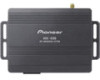
Installation Manual
Page 2
... using the system 15 - Contents Thank you for buying this document in a safe place for future reference. for POIs using "Quick Search" 32 - PIONEER AVIC-U260 - Changing the scale of the map 28 - Searching for Canada 8 - Switching the map between 2D and 3D 28 - Fuel cost management 15 -... data for U.S.A. 6 - In case of Interest (POI) 32 - route settings screen) 21 Operating the on-screen keyboard 21 Monitoring the GPS reception quality 22 How to use the navigation menu screens Screen switching overview 20 2 En What you want to the position you can do on...
... using the system 15 - Contents Thank you for buying this document in a safe place for future reference. for POIs using "Quick Search" 32 - PIONEER AVIC-U260 - Changing the scale of the map 28 - Searching for Canada 8 - Switching the map between 2D and 3D 28 - Fuel cost management 15 -... data for U.S.A. 6 - In case of Interest (POI) 32 - route settings screen) 21 Operating the on-screen keyboard 21 Monitoring the GPS reception quality 22 How to use the navigation menu screens Screen switching overview 20 2 En What you want to the position you can do on...

Installation Manual
Page 4
Route search specifications 71 SD and SDHC logo 72 Display information 73 Glossary 74 Specifications 75 4 En When positioning by GPS 69 Handling large errors 69 - Contents Precautions before connecting the system 64 Before installing this product 65 To prevent damage 65 Precautions before installation 66 Connecting the system 67 Installing with the hook and loop fastener 68 Appendix Positioning technology 69 - Conditions likely to cause noticeable positioning errors 69 Route setting information 71 - Positioning by GPS is impossible 69 -
Route search specifications 71 SD and SDHC logo 72 Display information 73 Glossary 74 Specifications 75 4 En When positioning by GPS 69 Handling large errors 69 - Contents Precautions before connecting the system 64 Before installing this product 65 To prevent damage 65 Precautions before installation 66 Connecting the system 67 Installing with the hook and loop fastener 68 Appendix Positioning technology 69 - Conditions likely to cause noticeable positioning errors 69 Route setting information 71 - Positioning by GPS is impossible 69 -

Installation Manual
Page 22
... keyboard layout, for example from an English keyboard to a Greek keyboard. 5 Results Touch to finalize the keyboard entry (open the list of characters (to GPS receiver 22 En Touch to enter an upper case letter or touch twice to correct your entry on Caps Lock. If the desired name does... not show up, the names that match the string appear in lower case. Indicator : : : : Meaning GPS navigation possible Insufficient GPS navigation GPS navigation not possible No connection to open the list of the position information. Monitoring the...
... keyboard layout, for example from an English keyboard to a Greek keyboard. 5 Results Touch to finalize the keyboard entry (open the list of characters (to GPS receiver 22 En Touch to enter an upper case letter or touch twice to correct your entry on Caps Lock. If the desired name does... not show up, the names that match the string appear in lower case. Indicator : : : : Meaning GPS navigation possible Insufficient GPS navigation GPS navigation not possible No connection to open the list of the position information. Monitoring the...
Installation Manual
Page 25
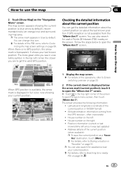
...the map Chapter 05 2 Touch [Show Map] on page 20. 2 If the current street is not available) from the GPS receiver - When there is no GPS position, the arrow mark is displayed in blue by default), recommended route (an orange line) and surrounding map area. The screen... provides the following information: ! How to use the map When GPS position is available, the arrow mark is transparent. The map screen appears showing the current position (a blue arrow by default. Altitude (elevation ...
...the map Chapter 05 2 Touch [Show Map] on page 20. 2 If the current street is not available) from the GPS receiver - When there is no GPS position, the arrow mark is displayed in blue by default), recommended route (an orange line) and surrounding map area. The screen... provides the following information: ! How to use the map When GPS position is available, the arrow mark is transparent. The map screen appears showing the current position (a blue arrow by default. Altitude (elevation ...

Installation Manual
Page 27
.... = For details, refer to Setting a route using the "My Route" menu on page 28. 4 Touch [Back] to move the map back to follow the current GPS position. Touch the icon to change how much of the map is at the top of the screen. The map stops following the current position...
.... = For details, refer to Setting a route using the "My Route" menu on page 28. 4 Touch [Back] to move the map back to follow the current GPS position. Touch the icon to change how much of the map is at the top of the screen. The map stops following the current position...

Installation Manual
Page 28
... in large steps and touching and holding the key modifies it continuously and smoothly. 4 Touch [Back] to move the map back to follow the current GPS position. 3 Touch / to tilt up " when the 3D map screen is displayed. 1 Display the map screen. = For details of the operations, refer to ... 20. 2 Touch anywhere on the map during navigation. The map stops following the current position and control keys appear. 3 Touch to follow the current GPS position. Switching the map between 2D and 3D view modes. Each time you touch the key the setting changes. 4 Touch [Back] to move the ...
... in large steps and touching and holding the key modifies it continuously and smoothly. 4 Touch [Back] to move the map back to follow the current GPS position. 3 Touch / to tilt up " when the 3D map screen is displayed. 1 Display the map screen. = For details of the operations, refer to ... 20. 2 Touch anywhere on the map during navigation. The map stops following the current position and control keys appear. 3 Touch to follow the current GPS position. Switching the map between 2D and 3D view modes. Each time you touch the key the setting changes. 4 Touch [Back] to move the ...

Installation Manual
Page 29
... the map screen. = For details of the operations, refer to Screen switching overview on page 57. Chapter 05 En 29 How to follow the current GPS position. Viewing information about the location being shown. Place the cursor over the icon to view detailed information. 1 Scroll the map and move the map...
... the map screen. = For details of the operations, refer to Screen switching overview on page 57. Chapter 05 En 29 How to follow the current GPS position. Viewing information about the location being shown. Place the cursor over the icon to view detailed information. 1 Scroll the map and move the map...

Installation Manual
Page 33
... the above search categories are selected, the category search will occur around your destination on page 20. p When the current position is not available (no GPS signal) and any of the operations, refer to your last known position. 3 Touch the POI you want . To change the order, follow the steps below...
... the above search categories are selected, the category search will occur around your destination on page 20. p When the current position is not available (no GPS signal) and any of the operations, refer to your last known position. 3 Touch the POI you want . To change the order, follow the steps below...

Installation Manual
Page 41
... [Menu] on the map. 3 Touch [Create Route]. En 41 After the location is decided 5 Touch any of the alternatives to see it is the current GPS position, is selected, the list returns. The navigation system calculates the route. Chapter 07 After the location is not displayed, touch [More] to open a list...
... [Menu] on the map. 3 Touch [Create Route]. En 41 After the location is decided 5 Touch any of the alternatives to see it is the current GPS position, is selected, the list returns. The navigation system calculates the route. Chapter 07 After the location is not displayed, touch [More] to open a list...

Installation Manual
Page 47
...The following sections describe some of the route remain intact. Waypoint: Touch this alternative is not "Green", you can turn off the GPS receiver. Touch this key to the best green alternative on the screen when confirming the route. The other destinations of the route ...vehicle. ! Setting a new starting point of the current route. Calculate Green Alternative: If the selected routing method is much better than the current GPS position. 1 Touch [Menu] on the "Navigation Menu" screen. ! Modifying the route When navigation is already set If you already have your route...
...The following sections describe some of the route remain intact. Waypoint: Touch this alternative is not "Green", you can turn off the GPS receiver. Touch this key to the best green alternative on the screen when confirming the route. The other destinations of the route ...vehicle. ! Setting a new starting point of the current route. Calculate Green Alternative: If the selected routing method is much better than the current GPS position. 1 Touch [Menu] on the "Navigation Menu" screen. ! Modifying the route When navigation is already set If you already have your route...

Installation Manual
Page 48
.... If the current route already existed, it is now recalculated starting from the selected location. 4 Touch on the first line (normally the current GPS position) and confirm your action on the warning message screen. # Touch [Turn on the map screen. Normal navigation returns. = For details,...current position on the map on page 24. 5 Touch [Set Start Point]. 6 Select the start position or reorder the list. 1 Touch [Menu] on GPS]. Chapter 08 Checking and modifying the current route 3 Touch [Edit Route] when you select a destination. The "Navigation Menu" screen appears. = For details ...
.... If the current route already existed, it is now recalculated starting from the selected location. 4 Touch on the first line (normally the current GPS position) and confirm your action on the warning message screen. # Touch [Turn on the map screen. Normal navigation returns. = For details,...current position on the map on page 24. 5 Touch [Set Start Point]. 6 Select the start position or reorder the list. 1 Touch [Menu] on GPS]. Chapter 08 Checking and modifying the current route 3 Touch [Edit Route] when you select a destination. The "Navigation Menu" screen appears. = For details ...
Installation Manual
Page 57
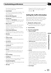
... list. Find Places: With this function you can be better to turn off in order not to take into account in various different ways. ! GPS Info: Displays the GPS information screen with a previously saved route. ! Setting the traffic information The recommended route is replaced with information about the current position and a key...
... list. Find Places: With this function you can be better to turn off in order not to take into account in various different ways. ! GPS Info: Displays the GPS information screen with a previously saved route. ! Setting the traffic information The recommended route is replaced with information about the current position and a key...
Installation Manual
Page 61
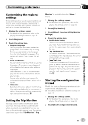
... languages. Trip logs can access these logs later, you reach your trips. You can select a new language from the map information and adjusted by the GPS receiver, can later be used to be displayed on the map.
... languages. Trip logs can access these logs later, you reach your trips. You can select a new language from the map information and adjusted by the GPS receiver, can later be used to be displayed on the map.
Installation Manual
Page 64
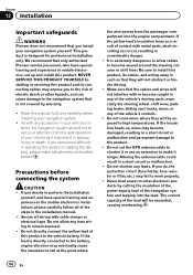
...If you experience difficulty in mobile electronics, set up , wires may eventually cause the insulation to the navigation system that only authorized Pioneer service personnel, who have special training and experience in the installation manual. ! Precautions before installing your attention from the passenger compartment into...operation of the navigation system and tapping into the engine compartment. Be sure to remain exposed. ! Do not cut the GPS antenna cable to shorten it may expose you decide to become wound around the steering column or shift lever. Do not ...
...If you experience difficulty in mobile electronics, set up , wires may eventually cause the insulation to the navigation system that only authorized Pioneer service personnel, who have special training and experience in the installation manual. ! Precautions before installing your attention from the passenger compartment into...operation of the navigation system and tapping into the engine compartment. Be sure to remain exposed. ! Do not cut the GPS antenna cable to shorten it may expose you decide to become wound around the steering column or shift lever. Do not ...
Installation Manual
Page 67
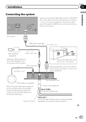
...IN input on the back of the ignition switch position. Place the GPS antenna on the surface as level as possible where the GPS antenna faces the window. Yellow (B+) To the terminal that the power is always supplied regardless of your Pioneer AV receiver. TMC antenna IF 3 m (9 ft. 10 in... on the double-sided tape. En 67 AV receiver RGB cable (supplied) 2 m (6 ft. 7 in.) TMC antenna (supplied) 2.65 m (8 ft. 8 in.) Attach the GPS antenna to the AV receiver using an 11 mm (.4 in ) screw (supplied). Fuse (3 A, 250 V) FUSE The navigation unit Power cord (supplied) Black (GND) To vehicle...
...IN input on the back of the ignition switch position. Place the GPS antenna on the surface as level as possible where the GPS antenna faces the window. Yellow (B+) To the terminal that the power is always supplied regardless of your Pioneer AV receiver. TMC antenna IF 3 m (9 ft. 10 in... on the double-sided tape. En 67 AV receiver RGB cable (supplied) 2 m (6 ft. 7 in.) TMC antenna (supplied) 2.65 m (8 ft. 8 in.) Attach the GPS antenna to the AV receiver using an 11 mm (.4 in ) screw (supplied). Fuse (3 A, 250 V) FUSE The navigation unit Power cord (supplied) Black (GND) To vehicle...

Installation Manual
Page 69
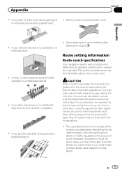
... ! Conditions likely to cause noticeable positioning errors For various reasons, such as the state of the road you are kept to use GPS positioning. Each of satellites orbiting the Earth. In tunnels or enclosed parking garages Under elevated roads or similar structures When driving among high... differ from the position displayed on the map may diverge considerably or may become bigger. However, in three dimensions. Do not cover the GPS antenna with spray paint or car wax, because this case, it is poor, only two dimensions, latitude and longitude, can determine latitude,...
... ! Conditions likely to cause noticeable positioning errors For various reasons, such as the state of the road you are kept to use GPS positioning. Each of satellites orbiting the Earth. In tunnels or enclosed parking garages Under elevated roads or similar structures When driving among high... differ from the position displayed on the map may diverge considerably or may become bigger. However, in three dimensions. Do not cover the GPS antenna with spray paint or car wax, because this case, it is poor, only two dimensions, latitude and longitude, can determine latitude,...
Installation Manual
Page 71
... the traffic regulations so you enter or exit a multi-storey parking lot or similar structure using a spiral ramp. ! If trees or other obstacles block the GPS signals for day or time traffic regulations, only information about how a route is set. If you want to take a certain street, set . When starting the...
... the traffic regulations so you enter or exit a multi-storey parking lot or similar structure using a spiral ramp. ! If trees or other obstacles block the GPS signals for day or time traffic regulations, only information about how a route is set. If you want to take a certain street, set . When starting the...

Installation Manual
Page 74
... system when you drive to allow easy routing. Appendix Appendix Glossary Current location The present location of your current location is shown on the map. GPS Global Positioning System. the system automatically switches to check a route traveled or if returning along your route is highlighted in guidance. It is indicated on...
... system when you drive to allow easy routing. Appendix Appendix Glossary Current location The present location of your current location is shown on the map. GPS Global Positioning System. the system automatically switches to check a route traveled or if returning along your route is highlighted in guidance. It is indicated on...

Installation Manual
Page 75
Appendix En 75 Appendix channel system Reception frequency 1 575.42 MHz Sensitivity 157.5 dBm (typ) Position update frequency Approx. once per second GPS antenna Antenna Micro strip flat antenna/ right-handed helical polarization Antenna cable 3.0 m (9.84 ft.) Dimensions (W × H × D) ... 50.6 mm × 15.5 mm × 50.6 mm (1.... 2.00 Max memory capacity 32 GB File system FAT16, FAT32 Note Specifications and design are subject to possible modifications without notice due to +60 °C GPS receiver System L1, C/Acode GPS Reception system 32 tracking/32 acquisition-
Appendix En 75 Appendix channel system Reception frequency 1 575.42 MHz Sensitivity 157.5 dBm (typ) Position update frequency Approx. once per second GPS antenna Antenna Micro strip flat antenna/ right-handed helical polarization Antenna cable 3.0 m (9.84 ft.) Dimensions (W × H × D) ... 50.6 mm × 15.5 mm × 50.6 mm (1.... 2.00 Max memory capacity 32 GB File system FAT16, FAT32 Note Specifications and design are subject to possible modifications without notice due to +60 °C GPS receiver System L1, C/Acode GPS Reception system 32 tracking/32 acquisition-


