Installation Manual
Page 1
English Owner's Manual ADD-ON NAVIGATION SYSTEM AVIC-U260 For details on software updates, visit www.naviextras.com.
English Owner's Manual ADD-ON NAVIGATION SYSTEM AVIC-U260 For details on software updates, visit www.naviextras.com.
Installation Manual
Page 16
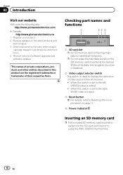
... containing map data is inserted at the following site: http://www.pioneerelectronics.com In Canada http://www.pioneerelectronics.ca 1 Register your product. 2 Receive updates on the latest products and technologies. 3 Download owner's manuals, order product catalogs, research new products, and much more. 4 Receive notices of ... of software upgrades and software updates. p Do not erase the map data stored on page 17. 4 Power indicator Inserting an SD memory card p The included SD memory card must be inserted into the SD card slot for prior to using the AVIC-U260 for the first time. 16...
... containing map data is inserted at the following site: http://www.pioneerelectronics.com In Canada http://www.pioneerelectronics.ca 1 Register your product. 2 Receive updates on the latest products and technologies. 3 Download owner's manuals, order product catalogs, research new products, and much more. 4 Receive notices of ... of software upgrades and software updates. p Do not erase the map data stored on page 17. 4 Power indicator Inserting an SD memory card p The included SD memory card must be inserted into the SD card slot for prior to using the AVIC-U260 for the first time. 16...
Installation Manual
Page 25
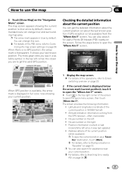
... POI icons, refer to Customizing the map screen settings on the screen. Follow the steps below the arrow mark (current position), touch it was last updated ! screen. Altitude (elevation information coming from the "Where Am I ?" ites" destination, touch [More]. = For details, refer to Storing a location in WGS84 format) ! screen. screen. # Touch...
... POI icons, refer to Customizing the map screen settings on the screen. Follow the steps below the arrow mark (current position), touch it was last updated ! screen. Altitude (elevation information coming from the "Where Am I ?" ites" destination, touch [More]. = For details, refer to Storing a location in WGS84 format) ! screen. screen. # Touch...

Installation Manual
Page 63
... pressure, etc. ! Touch [Details] to see the exact sunrise and sunset times for all your current location, all your route points (your journeys. En 63 Updates and Extras: Visit www.naviextras.com to see the trip statistics, speed and altitude profile. Fuel Consumption: The Fuel consumption monitor helps you keep track...
... pressure, etc. ! Touch [Details] to see the exact sunrise and sunset times for all your current location, all your route points (your journeys. En 63 Updates and Extras: Visit www.naviextras.com to see the trip statistics, speed and altitude profile. Fuel Consumption: The Fuel consumption monitor helps you keep track...

Installation Manual
Page 69
... dimensions, latitude and longitude, can also degrade the signals, so keep the antenna clear. In such case, once GPS reception is good, GPS can be updated. En 69 When the signals are strong and reception is restored, accuracy will be obtained and positioning errors are somewhat greater. When positioning by GPS...
... dimensions, latitude and longitude, can also degrade the signals, so keep the antenna clear. In such case, once GPS reception is good, GPS can be updated. En 69 When the signals are strong and reception is restored, accuracy will be obtained and positioning errors are somewhat greater. When positioning by GPS...

Installation Manual
Page 73
... 36 37 37 38 41 47, 48 43 43 49 55 56 53, 57 44, 45 58 58 59 60 61 61 61 62 More... Updates and Extras Unit Converter Clothing Calculator Fuel Consumption Sunrise & Sunset Trip Monitor Country Information Help Appendix Page 63 Appendix En 73
... 36 37 37 38 41 47, 48 43 43 49 55 56 53, 57 44, 45 58 58 59 60 61 61 61 62 More... Updates and Extras Unit Converter Clothing Calculator Fuel Consumption Sunrise & Sunset Trip Monitor Country Information Help Appendix Page 63 Appendix En 73

Installation Manual
Page 75
... L1, C/Acode GPS Reception system 32 tracking/32 acquisition- Appendix En 75 Appendix channel system Reception frequency 1 575.42 MHz Sensitivity 157.5 dBm (typ) Position update frequency Approx.
... L1, C/Acode GPS Reception system 32 tracking/32 acquisition- Appendix En 75 Appendix channel system Reception frequency 1 575.42 MHz Sensitivity 157.5 dBm (typ) Position update frequency Approx.

