Installation Manual
Page 16
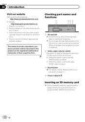
... Power indicator Inserting an SD memory card p The included SD memory card must be inserted into the SD card slot for prior to using the AVIC-U260 for the first time. 16 En When the switch is set to the right, WVGA video is output. ! The names of private corporations, ....com In Canada http://www.pioneerelectronics.ca 1 Register your product. 2 Receive updates on the SD memory card (inserted at the factory). Chapter 02 Introduction Visit our website Visit us at the factory. p Do not erase the map data stored on the latest products and technologies. 3 Download owner's manuals, ...
... Power indicator Inserting an SD memory card p The included SD memory card must be inserted into the SD card slot for prior to using the AVIC-U260 for the first time. 16 En When the switch is set to the right, WVGA video is output. ! The names of private corporations, ....com In Canada http://www.pioneerelectronics.ca 1 Register your product. 2 Receive updates on the SD memory card (inserted at the factory). Chapter 02 Introduction Visit our website Visit us at the factory. p Do not erase the map data stored on the latest products and technologies. 3 Download owner's manuals, ...
Installation Manual
Page 25
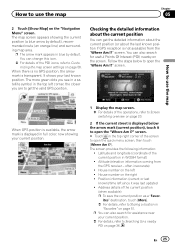
... You can also search for a nearby POI on the "Navigation Menu" screen. Follow the steps below the arrow mark (current position), touch it was last updated ! screen. # Touch in the top right corner of the POI icons, refer to open the "Where Am I?" ites" destination, touch [More]. = ..., refer to open the quick menu screen, then touch [Where Am I?]. How to open the "Where Am I?" screen. How to use the map Chapter 05 2 Touch [Show Map] on page 36. Address details of the current position in blue by default), recommended route (an orange line) and surrounding...
... You can also search for a nearby POI on the "Navigation Menu" screen. Follow the steps below the arrow mark (current position), touch it was last updated ! screen. # Touch in the top right corner of the POI icons, refer to open the "Where Am I?" ites" destination, touch [More]. = ..., refer to open the quick menu screen, then touch [Where Am I?]. How to open the "Where Am I?" screen. How to use the map Chapter 05 2 Touch [Show Map] on page 36. Address details of the current position in blue by default), recommended route (an orange line) and surrounding...

Installation Manual
Page 63
... current location, all your calculation needs. Information may include speed limits on the map. En 63 Track logs can also access program usage statistics. You can be exported to see how navigation works. Updates and Extras: Visit www.naviextras.com to see the exact sunrise and sunset times... for later use. ! Your current location and route points are all your journeys. Touch one of the map screen, turn on the map screen. Touch [MODE] for additional...
... current location, all your calculation needs. Information may include speed limits on the map. En 63 Track logs can also access program usage statistics. You can be exported to see how navigation works. Updates and Extras: Visit www.naviextras.com to see the exact sunrise and sunset times... for later use. ! Your current location and route points are all your journeys. Touch one of the map screen, turn on the map screen. Touch [MODE] for additional...

Installation Manual
Page 69
... information. Appendix Appendix Appendix Positioning technology Positioning by GPS is impossible ! This ensures that signals from any open area on the map screen. The accuracy of GPS signals. In tunnels or enclosed parking garages Under elevated roads or similar structures When driving among high...restored, accuracy will be obtained and positioning errors are strong and reception is poor, only two dimensions, latitude and longitude, can be updated. But if signal quality is good, GPS can also degrade the signals, so keep the antenna clear. When the signals are somewhat ...
... information. Appendix Appendix Appendix Positioning technology Positioning by GPS is impossible ! This ensures that signals from any open area on the map screen. The accuracy of GPS signals. In tunnels or enclosed parking garages Under elevated roads or similar structures When driving among high...restored, accuracy will be obtained and positioning errors are strong and reception is poor, only two dimensions, latitude and longitude, can be updated. But if signal quality is good, GPS can also degrade the signals, so keep the antenna clear. When the signals are somewhat ...

Installation Manual
Page 73
Updates and Extras Unit Converter Clothing Calculator Fuel Consumption Sunrise & Sunset Trip Monitor Country Information Help Appendix Page 63 Appendix En 73 Settings Sound and Warnings Customize Quick Menu Traffic Route Settings User Profiles Map Settings Visual Guidance Settings Display Regional Trip Monitor Start Configuration Wizard Reset to Defaults Page 30 32...56 53, 57 44, 45 58 58 59 60 61 61 61 62 More... Appendix Display information Find Find Address Find Places Find on Map Favorites History Coordinate My Route Create Route Edit Route Overview Avoidances Cancel Route More...
Updates and Extras Unit Converter Clothing Calculator Fuel Consumption Sunrise & Sunset Trip Monitor Country Information Help Appendix Page 63 Appendix En 73 Settings Sound and Warnings Customize Quick Menu Traffic Route Settings User Profiles Map Settings Visual Guidance Settings Display Regional Trip Monitor Start Configuration Wizard Reset to Defaults Page 30 32...56 53, 57 44, 45 58 58 59 60 61 61 61 62 More... Appendix Display information Find Find Address Find Places Find on Map Favorites History Coordinate My Route Create Route Edit Route Overview Avoidances Cancel Route More...


