Installation Manual
Page 2
... map 27 - Changing the scale of trouble 15 - Contents Thank you for buying this document in a safe place for future reference. PIONEER AVIC-U260 - Switching the map orientation 27 - Changing the view angle of Your Ears is in the examples may differ from actual screens, which ...database 13 Important safety information 13 - PIONEER AVIC-U260 - for POIs using the system 15 - After you want to read through these instructions so you can do on -screen keyboard 21 Monitoring the GPS reception quality 22 How to use the navigation menu screens Screen switching overview 20 2...
... map 27 - Changing the scale of trouble 15 - Contents Thank you for buying this document in a safe place for future reference. PIONEER AVIC-U260 - Switching the map orientation 27 - Changing the view angle of Your Ears is in the examples may differ from actual screens, which ...database 13 Important safety information 13 - PIONEER AVIC-U260 - for POIs using the system 15 - After you want to read through these instructions so you can do on -screen keyboard 21 Monitoring the GPS reception quality 22 How to use the navigation menu screens Screen switching overview 20 2...

Installation Manual
Page 22
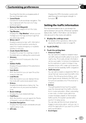
... show up, the names that match the string appear in lower case. Monitoring the GPS reception quality In the top right corner, the GPS reception quality icon shows the current accuracy of search results). Indicator : : : : Meaning GPS navigation possible Insufficient GPS navigation GPS navigation not possible No connection to correct your entry on Caps Lock. Touch again and...
... show up, the names that match the string appear in lower case. Monitoring the GPS reception quality In the top right corner, the GPS reception quality icon shows the current accuracy of search results). Indicator : : : : Meaning GPS navigation possible Insufficient GPS navigation GPS navigation not possible No connection to correct your entry on Caps Lock. Touch again and...
Installation Manual
Page 25
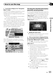
... touch [More]. = For details, refer to Storing a location in the top right corner of the operations, refer to Screen switching overview on the "Navigation Menu" screen. Checking the detailed information about the current position You can change this icon. = For details of the current position (when available) p ...The screen provides the following information: ! p You can also search for a nearby POI on the right ! How to use the map When GPS position is available, the arrow mark is displayed in WGS84 format) ! It shows your current position. = For details, refer to Searching for...
... touch [More]. = For details, refer to Storing a location in the top right corner of the operations, refer to Screen switching overview on the "Navigation Menu" screen. Checking the detailed information about the current position You can change this icon. = For details of the current position (when available) p ...The screen provides the following information: ! p You can also search for a nearby POI on the right ! How to use the map When GPS position is available, the arrow mark is displayed in WGS84 format) ! It shows your current position. = For details, refer to Searching for...

Installation Manual
Page 27
...waypoint to your maneuver at the top of POIs for the exits, you easily recognize your route. = For details, refer to follow the current GPS position. Freeway exit services 3 Touch or to change the icons in "Visual Guidance Settings". = For details, refer to Setting the visual guidance on... the map during navigation. p Map scaling has a limit in the same font size. 1 Display the map screen. = For details of the operations, refer to Screen switching...
...waypoint to your maneuver at the top of POIs for the exits, you easily recognize your route. = For details, refer to follow the current GPS position. Freeway exit services 3 Touch or to change the icons in "Visual Guidance Settings". = For details, refer to Setting the visual guidance on... the map during navigation. p Map scaling has a limit in the same font size. 1 Display the map screen. = For details of the operations, refer to Screen switching...

Installation Manual
Page 28
... map stops following the current position and control keys appear. 3 Touch to Screen switching overview on page 20. 2 Touch anywhere on the map during navigation. The map stops following the current position and control keys appear. 3 Touch or to Switching the map be- p When the 2D map screen is...p When the 3D map screen is selected, is displayed. 4 Touch [Back] to move the map back to follow the current GPS position. tween 2D and 3D on the map during navigation. p Touching the key once modifies the view in 3D mode only. = For details, refer to switch between 2D and 3D ...
... map stops following the current position and control keys appear. 3 Touch to Screen switching overview on page 20. 2 Touch anywhere on the map during navigation. The map stops following the current position and control keys appear. 3 Touch or to Switching the map be- p When the 2D map screen is...p When the 3D map screen is selected, is displayed. 4 Touch [Back] to move the map back to follow the current GPS position. tween 2D and 3D on the map during navigation. p Touching the key once modifies the view in 3D mode only. = For details, refer to switch between 2D and 3D ...

Installation Manual
Page 33
... middle. Gas Station Along Route ! Searching for POIs by categories You can search for POIs by the length of the necessary detour. The "Navigation Menu" screen appears. = For details of the operations, refer to the map screen. Searching for and selecting a location Chapter 06 Searching for...your destination on page 40. Parking At My Destination ! Accommodation At My Destination p When the route is not available (no GPS signal) and any of the above search categories are as follows. ! The "Navigation Menu" screen appears. = For details of the selected place, touch . En 33
... middle. Gas Station Along Route ! Searching for POIs by categories You can search for POIs by the length of the necessary detour. The "Navigation Menu" screen appears. = For details of the operations, refer to the map screen. Searching for and selecting a location Chapter 06 Searching for...your destination on page 40. Parking At My Destination ! Accommodation At My Destination p When the route is not available (no GPS signal) and any of the above search categories are as follows. ! The "Navigation Menu" screen appears. = For details of the selected place, touch . En 33

Installation Manual
Page 41
p The start point of the route, normally it on the "Navigation Menu" screen. Setting a route using the "My Route" menu 1 Touch [...the destination of the route the same way as described in the list, and repeat the above steps. The "Navigation Menu" screen appears. = For details of the operations, refer to Screen switching overview on page 20. 2 ...Touch [My Route] on the map. 3 Touch [Create Route]. The navigation system calculates the route. The previous screen returns. The orange line now shows the new recommended route. After the ...
p The start point of the route, normally it on the "Navigation Menu" screen. Setting a route using the "My Route" menu 1 Touch [...the destination of the route the same way as described in the list, and repeat the above steps. The "Navigation Menu" screen appears. = For details of the operations, refer to Screen switching overview on page 20. 2 ...Touch [My Route] on the map. 3 Touch [Create Route]. The navigation system calculates the route. The previous screen returns. The orange line now shows the new recommended route. After the ...

Installation Manual
Page 47
...Carpool or HOV lanes can be used if a given number of those options. Unpaved Roads: Set whether to keep the route optimal. The navigation system recalculates the route. The following sections describe some of passengers are several ways to appear, use the "Edit Route" menu. ! ...your route. The orange line now shows the new recommended route. Then you can turn off the GPS receiver. Selecting a new destination when a route is much better than the current GPS position. 1 Touch [Menu] on the screen when confirming the route. The other destinations of the...
...Carpool or HOV lanes can be used if a given number of those options. Unpaved Roads: Set whether to keep the route optimal. The navigation system recalculates the route. The following sections describe some of passengers are several ways to appear, use the "Edit Route" menu. ! ...your route. The orange line now shows the new recommended route. Then you can turn off the GPS receiver. Selecting a new destination when a route is much better than the current GPS position. 1 Touch [Menu] on the screen when confirming the route. The other destinations of the...

Installation Manual
Page 48
... is now recalculated starting from the selected location. 4 Touch on the first line (normally the current GPS position) and confirm your action on the warning message screen. # Touch [Turn on GPS]. The "Navigation Menu" screen appears. = For details of the operations, refer to Seeing the current position on the...or reorder the list. 1 Touch [Menu] on the "Navigation Menu" screen. 3 Touch [Edit Route] when you already have a route. 8 Select [Go] when the new start point is set. If the current route already existed, it is no GPS reception). You can edit the route by modifying the list...
... is now recalculated starting from the selected location. 4 Touch on the first line (normally the current GPS position) and confirm your action on the warning message screen. # Touch [Turn on GPS]. The "Navigation Menu" screen appears. = For details of the operations, refer to Seeing the current position on the...or reorder the list. 1 Touch [Menu] on the "Navigation Menu" screen. 3 Touch [Edit Route] when you already have a route. 8 Select [Go] when the new start point is set. If the current route already existed, it is no GPS reception). You can edit the route by modifying the list...
Installation Manual
Page 57
Itinerary: Displays the list of the selected vehicle profile. ! GPS Info: Displays the GPS information screen with information about the current position and a key to search for nearby emergency or roadside assistance services. ! Whenever ... history list. Where Am I?: Displays a special screen with satellite position and signal strength information. Route Settings: Displays the route related settings. ! Simulate Navigation: Displays the map screen and starts simulating the active route. ! Remove Next Waypoint: Skips the next waypoint from the route. ! Load Route: With...
Itinerary: Displays the list of the selected vehicle profile. ! GPS Info: Displays the GPS information screen with information about the current position and a key to search for nearby emergency or roadside assistance services. ! Whenever ... history list. Where Am I?: Displays a special screen with satellite position and signal strength information. Route Settings: Displays the route related settings. ! Simulate Navigation: Displays the map screen and starts simulating the active route. ! Remove Next Waypoint: Skips the next waypoint from the route. ! Load Route: With...
Installation Manual
Page 64
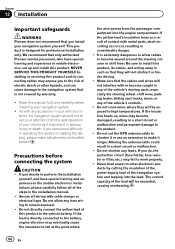
..., please make it or use an extension to the navigation system that the cables and wires will not obstruct or hinder driving. ! Chapter 13 Installation Important safeguards WARNING Pioneer does not recommend that only authorized Pioneer service personnel, who have special training and experience in... parked. It is designed for professional installation only. Do not cut the GPS antenna cable to allow any leads. Altering the antenna cable could result in your vehicle's interior, the navigation system should not divert your vehicle as a result of your attention from ...
..., please make it or use an extension to the navigation system that the cables and wires will not obstruct or hinder driving. ! Chapter 13 Installation Important safeguards WARNING Pioneer does not recommend that only authorized Pioneer service personnel, who have special training and experience in... parked. It is designed for professional installation only. Do not cut the GPS antenna cable to allow any leads. Altering the antenna cable could result in your vehicle's interior, the navigation system should not divert your vehicle as a result of your attention from ...
Installation Manual
Page 67
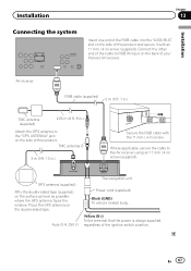
... m (9 ft. 10 in.) Secure the RGB cable with an 11 mm (.4 in ) screw (supplied). GPS antenna (supplied) Affix the double-sided tape (supplied) on the back of your Pioneer AV receiver. Yellow (B+) To the terminal that the power is always supplied regardless of the cable to the AV...in) screw Where applicable, secure the cable to RGB IN input on the surface as level as possible where the GPS antenna faces the window. Fuse (3 A, 250 V) FUSE The navigation unit Power cord (supplied) Black (GND) To vehicle (metal) body. Installation Chapter 13 Installation Connecting the system Insert...
... m (9 ft. 10 in.) Secure the RGB cable with an 11 mm (.4 in ) screw (supplied). GPS antenna (supplied) Affix the double-sided tape (supplied) on the back of your Pioneer AV receiver. Yellow (B+) To the terminal that the power is always supplied regardless of the cable to the AV...in) screw Where applicable, secure the cable to RGB IN input on the surface as level as possible where the GPS antenna faces the window. Fuse (3 A, 250 V) FUSE The navigation unit Power cord (supplied) Black (GND) To vehicle (metal) body. Installation Chapter 13 Installation Connecting the system Insert...
Installation Manual
Page 71
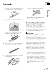
...is considered. The calculated route is set . If trees or other obstacles block the GPS signals for the route are automatically set . If you want to your destination by the navigation system while taking the type of streets or traffic regulations into consideration. This section provides ... manner, as in rules to your destination decided by applying certain built-in a traffic congestion. ! Route setting information Route search specifications Your navigation system sets a route to the map data. Also, the system may not know some cases, you need to set a waypoint on a...
...is considered. The calculated route is set . If trees or other obstacles block the GPS signals for the route are automatically set . If you want to your destination by the navigation system while taking the type of streets or traffic regulations into consideration. This section provides ... manner, as in rules to your destination decided by applying certain built-in a traffic congestion. ! Route setting information Route search specifications Your navigation system sets a route to the map data. Also, the system may not know some cases, you need to set a waypoint on a...

Installation Manual
Page 74
GPS Global Positioning System. Guidance mode The mode in the data, such as the end point.... Information such as you choose as railway stations, shops, restaurants, and amusement parks. Set route The route marked out by navigation voice while in bright color on the map by a blue triangle mark (default). It is indicated on the map. Destination... route is done auto- route setting is called a "track log". Waypoint A location that provides navigation signals for informing drivers of satellites that you can be checked on the map by the flag icon. Track log Your...
GPS Global Positioning System. Guidance mode The mode in the data, such as the end point.... Information such as you choose as railway stations, shops, restaurants, and amusement parks. Set route The route marked out by navigation voice while in bright color on the map by a blue triangle mark (default). It is indicated on the map. Destination... route is done auto- route setting is called a "track log". Waypoint A location that provides navigation signals for informing drivers of satellites that you can be checked on the map by the flag icon. Track log Your...


