Owner's Manual
Page 3
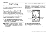
...backlight (page 4). • To extend the DC 30 battery life, turn the unit off when you are not using your Astro 220. In the USA contact Garmin Product Support by completing our online registration today! Tips and Shortcuts • Press MENU twice to return to the Main Menu ... and other useful items. • Unlock optional maps. • Access MotionBased® Web-based activity tracker where you can view your saved tracks. • Download geocaches to move backward through your steps. • To extend battery life of the Astro 220, turn the unit off when you are not tracking...
...backlight (page 4). • To extend the DC 30 battery life, turn the unit off when you are not using your Astro 220. In the USA contact Garmin Product Support by completing our online registration today! Tips and Shortcuts • Press MENU twice to return to the Main Menu ... and other useful items. • Unlock optional maps. • Access MotionBased® Web-based activity tracker where you can view your saved tracks. • Download geocaches to move backward through your steps. • To extend battery life of the Astro 220, turn the unit off when you are not tracking...
Owner's Manual
Page 4
... Contents Introduction i Tips and Shortcuts i Product Registration i Contact Garmin i myGarmin i DC 30 Battery Warnings iv Getting Started 1 Unit Overview 1 Installing the Batteries in the Astro 220 2 Using the Astro 220 Keypad Functions 3 Turning the Astro 220 On 4 Charging the DC 30 4 Acquiring GPS Satellite Signals 5 Calibrating the Astro 220 Compass 6 Operating the Astro 220 6 Manual Conventions 7 On-Screen Messages 7 Dog Tracking 8 Communicating...
... Contents Introduction i Tips and Shortcuts i Product Registration i Contact Garmin i myGarmin i DC 30 Battery Warnings iv Getting Started 1 Unit Overview 1 Installing the Batteries in the Astro 220 2 Using the Astro 220 Keypad Functions 3 Turning the Astro 220 On 4 Charging the DC 30 4 Acquiring GPS Satellite Signals 5 Calibrating the Astro 220 Compass 6 Operating the Astro 220 6 Manual Conventions 7 On-Screen Messages 7 Dog Tracking 8 Communicating...
Owner's Manual
Page 5
...Main Menu Setup 46 Map Setup 46 Routing Setup 49 Geocache Setup 51 Marine Alarms Setup 51 Time Setup 51 Units Setup 52 Heading Setup 52 Calibration Setup 53 Altimeter Setup 53 Introduction Appendix 54 Specifications 54 Optional Accessories 56 Transferring Data 56 Caring for the Astro 220 System 60 Software ...License Agreement 61 Index 64 Astro Dog Tracking System Owner's Manual iii
...Main Menu Setup 46 Map Setup 46 Routing Setup 49 Geocache Setup 51 Marine Alarms Setup 51 Time Setup 51 Units Setup 52 Heading Setup 52 Calibration Setup 53 Altimeter Setup 53 Introduction Appendix 54 Specifications 54 Optional Accessories 56 Transferring Data 56 Caring for the Astro 220 System 60 Software ...License Agreement 61 Index 64 Astro Dog Tracking System Owner's Manual iii
Owner's Manual
Page 9
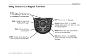
... arrow. MENU-Press to the Main Menu. ENT (Enter)-Press to enter highlighted options, select data, or confirm on the Map page. Rocker-Press up or down , left, or right to highlight options and to enter data, or to move backward to view page options. Press ... to view the Main Menu. Press to scroll up , down a list on any time to view the Dog Tracker page. Getting Started MAP-Press to view the Map page. DOG-Press at any other page. Using the Astro 220 Keypad Functions IN/OUT zoom-Press to zoom in or out on ‑screen messages.
... arrow. MENU-Press to the Main Menu. ENT (Enter)-Press to enter highlighted options, select data, or confirm on the Map page. Rocker-Press up or down , left, or right to highlight options and to enter data, or to move backward to view page options. Press ... to view the Main Menu. Press to scroll up , down a list on any time to view the Dog Tracker page. Getting Started MAP-Press to view the Map page. DOG-Press at any other page. Using the Astro 220 Keypad Functions IN/OUT zoom-Press to zoom in or out on ‑screen messages.
Owner's Manual
Page 14
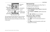
... that you , and the status of the dog. If you are using a DC 30 that was packaged with your Astro 220 System was linked with the Astro 220 at the factory. The Astro 220 can keep track of the dog, the distance away from you ordered separately, follow the instructions for adding a new dog... on the map, and adding dogs to the Dog List. Dog pointer (direction to the dog) Dog status icon Distance to the Astro 220, and the Astro 220 will not indicate the location of dogs. Note: The DC 30 does not transmit...
... that you , and the status of the dog. If you are using a DC 30 that was packaged with your Astro 220 System was linked with the Astro 220 at the factory. The Astro 220 can keep track of the dog, the distance away from you ordered separately, follow the instructions for adding a new dog... on the map, and adding dogs to the Dog List. Dog pointer (direction to the dog) Dog status icon Distance to the Astro 220, and the Astro 220 will not indicate the location of dogs. Note: The DC 30 does not transmit...
Owner's Manual
Page 15
Dog Tracking Naming the Dog The Astro 220 assigns a name such as Dog or Dog 1 to every Dog Unit (DC 30) linked to ... field Position update rate and dog DC 30 battery communication capacity ID number (page 13) DC 30 communication DC 30 GPS signal strength signal strength Dog Information Page The Dog Information page displays the status of the dog (Running, Sitting, Treed...and the track log (page 30) for that dog. Using Go To, Map, and Reset • Select Go To to navigate to your dog. • Select Map to view the location and movement of your location, the distance traveled, and...
Dog Tracking Naming the Dog The Astro 220 assigns a name such as Dog or Dog 1 to every Dog Unit (DC 30) linked to ... field Position update rate and dog DC 30 battery communication capacity ID number (page 13) DC 30 communication DC 30 GPS signal strength signal strength Dog Information Page The Dog Information page displays the status of the dog (Running, Sitting, Treed...and the track log (page 30) for that dog. Using Go To, Map, and Reset • Select Go To to navigate to your dog. • Select Map to view the location and movement of your location, the distance traveled, and...

Owner's Manual
Page 17
...the following: • The location of your position. As you are facing. For more information about the Map page features and custom settings, refer to North Up (page 47). Astro Dog Tracking System Owner's Manual 11 When you are tracking is identified and the dog pointer indicates its movements... to page 46. To view the Dog Tracker page: Press DOG. At less than 30 feet (9.1 meters) away. Note: When the Map page is in the direction you are holding the Astro 220 level and the dog is farther than that the Astro 220 cannot determine the location of the dog.
...the following: • The location of your position. As you are facing. For more information about the Map page features and custom settings, refer to North Up (page 47). Astro Dog Tracking System Owner's Manual 11 When you are tracking is identified and the dog pointer indicates its movements... to page 46. To view the Dog Tracker page: Press DOG. At less than 30 feet (9.1 meters) away. Note: When the Map page is in the direction you are holding the Astro 220 level and the dog is farther than that the Astro 220 cannot determine the location of the dog.

Owner's Manual
Page 20
... a different time, select the Time field. Advanced-displays advanced options. • Find (page 20) • GPS Applications (page 24) • Accessories (page 41) • Settings (page 44) Astro Dog Tracking System Owner's Manual Select Use Find Menu to view locations stored on -screen keypad or select the New...shown on the Main Menu can be moved, deleted, or added as described on page 46. Main Menu Main Menu To open the on the map. View Hunting Almanac-provides predicted best times for hunting and fishing for a specific date and location. • To view predictions for a different...
... a different time, select the Time field. Advanced-displays advanced options. • Find (page 20) • GPS Applications (page 24) • Accessories (page 41) • Settings (page 44) Astro Dog Tracking System Owner's Manual Select Use Find Menu to view locations stored on -screen keypad or select the New...shown on the Main Menu can be moved, deleted, or added as described on page 46. Main Menu Main Menu To open the on the map. View Hunting Almanac-provides predicted best times for hunting and fishing for a specific date and location. • To view predictions for a different...
Owner's Manual
Page 21
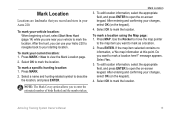
...4. Select OK to mark the location. Note: The Mark Covey option allows you want to mark the location. Press MAP. If the map item selected contains no information, a "No map information at this point. Astro Dog Tracking System Owner's Manual 15 To mark your vehicle location: When beginning a hunt, select Start New Hunt ... taken. Press MARK > New to open the on -screen keypad. To mark a specific hunting location: 1. Press MARK. 2. Use the Rocker to move the map pointer to the map item you record and store in your Astro 220. Select Yes. 3. Select OK to mark as a location. 2.
...4. Select OK to mark the location. Note: The Mark Covey option allows you want to mark the location. Press MAP. If the map item selected contains no information, a "No map information at this point. Astro Dog Tracking System Owner's Manual 15 To mark your vehicle location: When beginning a hunt, select Start New Hunt ... taken. Press MARK > New to open the on -screen keypad. To mark a specific hunting location: 1. Press MARK. 2. Use the Rocker to move the map pointer to the map item you record and store in your Astro 220. Select Yes. 3. Select OK to mark as a location. 2.
Owner's Manual
Page 22
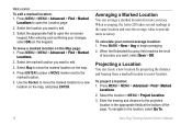
... show the marked location on the keypad). When averaging, the Astro 220 takes several readings at the bottom of accuracy you want to provide more accuracy. To calculate your changes, select OK (on the map. 4. When the Estimated Accuracy field reaches the level of the page. Projecting a Location You can... location to open the on-screen keypad. To project a location: 1. Press ENTER to place a MOVE marker next to the location, select Go To. 16 Astro Dog Tracking System Owner's Manual Press MARK > New > Avg to edit. 3. Select the location you want , select Save > OK. Use the Rocker to...
... show the marked location on the keypad). When averaging, the Astro 220 takes several readings at the bottom of accuracy you want to provide more accuracy. To calculate your changes, select OK (on the map. 4. When the Estimated Accuracy field reaches the level of the page. Projecting a Location You can... location to open the on-screen keypad. To project a location: 1. Press ENTER to place a MOVE marker next to the location, select Go To. 16 Astro Dog Tracking System Owner's Manual Press MARK > New > Avg to edit. 3. Select the location you want , select Save > OK. Use the Rocker to...

Owner's Manual
Page 23
... the map pointer away from Garmin MapSource City Navigator® North America NT Your current location Map scale Dog location Map Page Press MAP to your current location. Map Page Options Customize the Map page using MapSource® detailed mapping data as shown below. An accuracy circle represents the area containing your preferences (page 47). Map Page The Astro 220 includes...
... the map pointer away from Garmin MapSource City Navigator® North America NT Your current location Map scale Dog location Map Page Press MAP to your current location. Map Page Options Customize the Map page using MapSource® detailed mapping data as shown below. An accuracy circle represents the area containing your preferences (page 47). Map Page The Astro 220 includes...
Owner's Manual
Page 24
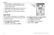
...Use the Rocker to the default settings. Press ENTER to show data fields on the Map page: 1. Press MENU > Data Fields. 2. Select an option > ENTER. 18 Astro Dog Tracking System Owner's Manual Map Page • Measure Distance (or Stop Measuring)-measures or stops measuring the distance ...(page 19) from your location to the map pointer. • Turn Declutter On (or Off)-eliminates or ...
...Use the Rocker to the default settings. Press ENTER to show data fields on the Map page: 1. Press MENU > Data Fields. 2. Select an option > ENTER. 18 Astro Dog Tracking System Owner's Manual Map Page • Measure Distance (or Stop Measuring)-measures or stops measuring the distance ...(page 19) from your location to the map pointer. • Turn Declutter On (or Off)-eliminates or ...

Owner's Manual
Page 25
Move the arrow to the point you want to another point. A push pin marks the point. 3. On the Map page, press MENU > Measure Distance. An arrow appears on the map at your current location. 2. The distance between two points: 1. End point of the measurement is shown in the upper-right corner of the measurement Map Page Astro Dog Tracking System Owner's Manual 19 Measuring Distance To measure the distance between the two points is labeled REF Measured distance Push pin indicates the beginning point of the Map page. Move the arrow to measure from and press ENTER.
Move the arrow to the point you want to another point. A push pin marks the point. 3. On the Map page, press MENU > Measure Distance. An arrow appears on the map at your current location. 2. The distance between two points: 1. End point of the measurement is shown in the upper-right corner of the measurement Map Page Astro Dog Tracking System Owner's Manual 19 Measuring Distance To measure the distance between the two points is labeled REF Measured distance Push pin indicates the beginning point of the Map page. Move the arrow to measure from and press ENTER.

Owner's Manual
Page 26
... the Find list > ENTER. • Save-saves the item as a location. • Map-shows the item as a location. • Go To-creates a route to find a location by Name. Select the item in the Astro 220 basemap. On the Information page of a location, press MENU > Change Reference. The... Map page opens. 20 Astro Dog Tracking System Owner's Manual When you have recently found: 1. To find > ENTER. 3. Select ...
... the Find list > ENTER. • Save-saves the item as a location. • Map-shows the item as a location. • Go To-creates a route to find a location by Name. Select the item in the Astro 220 basemap. On the Information page of a location, press MENU > Change Reference. The... Map page opens. 20 Astro Dog Tracking System Owner's Manual When you have recently found: 1. To find > ENTER. 3. Select ...

Owner's Manual
Page 27
... 1. Press MENU > MENU > Advanced > Find > Exits. Select an exit. Press MENU > MENU > Advanced > Find > Geocache. 2. Use the Rocker to move the map pointer to the map location you want , and press ENTER to open the information page. 3. To find a geocache: 1. 2. Press MENU > MENU > Advanced > Find > Marked Locations. 2. ...to navigate to the highlighted service are shown. 3. Go to my.garmin.com, log on, and click Go Geocaching for more information about the service. OR If the city you want is found, the Astro 220 marks the cache as found, logs an entry into the calendar, ...
... 1. Press MENU > MENU > Advanced > Find > Exits. Select an exit. Press MENU > MENU > Advanced > Find > Geocache. 2. Use the Rocker to move the map pointer to the map location you want , and press ENTER to open the information page. 3. To find a geocache: 1. 2. Press MENU > MENU > Advanced > Find > Marked Locations. 2. ...to navigate to the highlighted service are shown. 3. Go to my.garmin.com, log on, and click Go Geocaching for more information about the service. OR If the city you want is found, the Astro 220 marks the cache as found, logs an entry into the calendar, ...

Owner's Manual
Page 28
...or other public building. Select . 3. To use the Options menu: 1. Using Optional Detailed Maps If you have detailed mapping data, you are within a specified radius of an item (page 37). • Add To...item (page 20). • Change Reference-finds an item from another location on the keypad). 22 Astro Dog Tracking System Owner's Manual To find locations using a Find item as a tool for this location...View Hunting Almanac-displays Hunting tables for navigation. If your unit has a GPS fix, the field is populated with your current location. Enter the street number using the on-screen ...
...or other public building. Select . 3. To use the Options menu: 1. Using Optional Detailed Maps If you have detailed mapping data, you are within a specified radius of an item (page 37). • Add To...item (page 20). • Change Reference-finds an item from another location on the keypad). 22 Astro Dog Tracking System Owner's Manual To find locations using a Find item as a tool for this location...View Hunting Almanac-displays Hunting tables for navigation. If your unit has a GPS fix, the field is populated with your current location. Enter the street number using the on-screen ...
Owner's Manual
Page 35
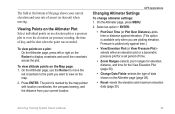
... bottom of the page shows your current elevation and your current location. GPS Applications Changing Altimeter Settings To change altimeter settings: 1. To view altitude ... the date when the point was recorded. On the Altimeter page, press MENU. 2. Astro Dog Tracking System Owner's Manual 29 To view points on a plot: On the Altimeter page, press left ... Plot (or View Pressure Plot)- Pressure is plotted only against elevation. (This option is marked by the map pointer with location coordinates, the compass bearing, and the distance from your rate of data shown on the Altimeter...
... bottom of the page shows your current elevation and your current location. GPS Applications Changing Altimeter Settings To change altimeter settings: 1. To view altitude ... the date when the point was recorded. On the Altimeter page, press MENU. 2. Astro Dog Tracking System Owner's Manual 29 To view points on a plot: On the Altimeter page, press left ... Plot (or View Pressure Plot)- Pressure is plotted only against elevation. (This option is marked by the map pointer with location coordinates, the compass bearing, and the distance from your rate of data shown on the Altimeter...
Owner's Manual
Page 38
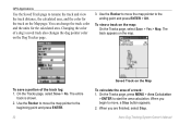
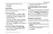
GPS Applications Use the Saved Track page to rename the track and view the track distance, the calculated area, and the color for the calculated area. To view a track on the map. Use the Rocker to the ending point and press ENTER > OK. You can change the track color and the units ...for the track on the Map page. On the Tracks page, select Save > No. When you begin to move the map pointer to move , a Stop button appears. 2. Astro Dog Tracking System Owner's Manual Changing the color of the track log: 1. On the Tracks...
GPS Applications Use the Saved Track page to rename the track and view the track distance, the calculated area, and the color for the calculated area. To view a track on the map. Use the Rocker to the ending point and press ENTER > OK. You can change the track color and the units ...for the track on the Map page. On the Tracks page, select Save > No. When you begin to move the map pointer to move , a Stop button appears. 2. Astro Dog Tracking System Owner's Manual Changing the color of the track log: 1. On the Tracks...
Owner's Manual
Page 39
... the track are available, a Use Map Data - Use the Rocker to move the map pointer to . 3. To view a track profile: 1. On the Saved Track page, press MENU > Profile. Astro Dog Tracking System Owner's Manual GPS Applications 3. Press left or right on the Rocker to the Garmin Web site www.garmin.com/cartography/ontheTrail/ for the track...
... the track are available, a Use Map Data - Use the Rocker to move the map pointer to . 3. To view a track profile: 1. On the Saved Track page, press MENU > Profile. Astro Dog Tracking System Owner's Manual GPS Applications 3. Press left or right on the Rocker to the Garmin Web site www.garmin.com/cartography/ontheTrail/ for the track...
Owner's Manual
Page 40
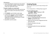
...With a saved track shown on the map, move the map pointer to the location on -screen keypad. To create and navigate a new route: 1. Select Use. 6. Press MARK to mark. 2. On the Routes page, select New. 2. Select OK to the route, repeat steps 2 through 5. 34 Astro Dog Tracking System Owner's Manual To ... roadways, or Follow Track to open the on the track that you want to open the Routes page: Press MENU > MENU > Advanced > GPS Applications > Routes. To edit location information, select the appropriate field, and press ENTER to retrace your changes, select OK (on the route. 5.
...With a saved track shown on the map, move the map pointer to the location on -screen keypad. To create and navigate a new route: 1. Select Use. 6. Press MARK to mark. 2. On the Routes page, select New. 2. Select OK to the route, repeat steps 2 through 5. 34 Astro Dog Tracking System Owner's Manual To ... roadways, or Follow Track to open the on the track that you want to open the Routes page: Press MENU > MENU > Advanced > GPS Applications > Routes. To edit location information, select the appropriate field, and press ENTER to retrace your changes, select OK (on the route. 5.


