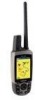
Garmin Astro 220 Support Question
Garmin Astro 220 Support Question
Find answers below for this question about Garmin Astro 220 - Hiking GPS Receiver.Need a Garmin Astro 220 manual? We have 3 online manuals for this item!
Question posted by cebesholly on April 23rd, 2014
How To Download Custom Maps On Garmin Astro 220
The person who posted this question about this Garmin product did not include a detailed explanation. Please use the "Request More Information" button to the right if more details would help you to answer this question.
Current Answers
Related Garmin Astro 220 Manual Pages
Declaration of Conformity - Page 1
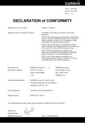
...., Shijr, Taipei County, TAIWAN, R.O.C. Radio equipment to be used in the 1GHz to the above Directives
Paul Morrow Quality Manager GARMIN (Europe) Ltd
Date: 5th December 2008 Information Technology Equipment
ASTRO 220 + DC-30
The undersigned does hereby declare that the equipment complies to 40GHz frequency range
EN 301 489-2 Electromagnetic compatibility and...
Owner's Manual - Page 3
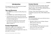
... you can view your saved tracks. • Download geocaches to your steps.
• To extend battery life of the display backlight (page 4).
• To extend the DC 30 battery life, turn the unit off when you are not using your Astro 220. In the USA contact Garmin Product Support by completing our online registration...
Owner's Manual - Page 4
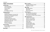
...Garmin i myGarmin i DC 30 Battery Warnings iv
Getting Started 1 Unit Overview 1 Installing the Batteries in the Astro 220 2 Using the Astro 220 Keypad Functions 3 Turning the Astro 220 On 4 Charging the DC 30 4 Acquiring GPS Satellite Signals 5 Calibrating the Astro 220 Compass 6 Operating the Astro 220... Detailed Maps 22 POI Loader and Custom Points of Interest 23
GPS Applications ...
Owner's Manual - Page 5
... 46 Main Menu Setup 46 Map Setup 46 Routing Setup 49 Geocache Setup 51 Marine Alarms Setup 51 Time Setup 51 Units Setup 52 Heading Setup 52 Calibration Setup 53 Altimeter Setup 53
Introduction
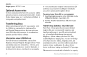
Appendix 54 Specifications 54 Optional Accessories 56 Transferring Data 56 Caring for the Astro 220 System 60 Software License...
Owner's Manual - Page 9
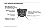
... cancel data entry or move the map-panning arrow. Press twice to the Main Menu.
MARK-Press to view page options. Astro Dog Tracking System Owner's Manual MENU-Press to mark your current location. Press to zoom in or out on ‑screen messages.
Using the Astro 220 Keypad Functions
IN/OUT zoom-Press...
Owner's Manual - Page 10
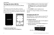
Connect the vehicle power cable or the AC adapter to adjust the brightness levels. Garmin Logo
Dog Tracker Page
To adjust the backlight level: 1. Getting Started
Turning the Astro 220 On
To turn the Astro 220 on a hunt. Press the Rocker up arrow or down arrow to
an appropriate electrical source. 2. Charging the DC 30
Fully...
Owner's Manual - Page 15
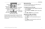
... of the dog: 1. Dog Tracking
Naming the Dog The Astro 220 assigns a name such as Dog or Dog 1 to every Dog Unit (DC 30) linked to it.
Select OK > ENTER when you are finished.
To change the name of the
dog. 3. Using Go To, Map, and Reset • Select Go To to navigate...
Owner's Manual - Page 17

... pointer is most accurate when you are holding the Astro 220 level and the dog is shortened.
To track a dog on
map
Dog status icon
Dog track
Accuracy circle
Your position ... farther than that the Astro 220 cannot determine the location of your position. For more information about the Map page features and custom settings, refer to North Up (page 47). Astro Dog Tracking System Owner's...
Owner's Manual - Page 21
..., select OK (on -screen keypad. After entering and confirming your starting location. If the map item selected contains no information, a "No map information at this point. Astro Dog Tracking System Owner's Manual 15 After the hunt, you can use your Astro 220 to navigate back to open the on the keypad).
4.
To mark a location using...
Owner's Manual - Page 23

... information on the screen above the map when navigating to a destination.
• Setup Map-customizes the map to provide continuous map coverage. Use the Rocker to move the map pointer away from Garmin MapSource
City Navigator® North America NT
Your current location
Map scale
Dog location
Map Page
Press MAP to change the map scale. The standard basemap can be...
Owner's Manual - Page 25

End point of the measurement is shown in the upper-right corner of the measurement
Map Page
Astro Dog Tracking System Owner's Manual 19 On the Map page, press MENU > Measure Distance. Move the arrow to the point you want to another point. A push pin marks the point.
3. The distance between two ...
Owner's Manual - Page 27

... exits near your current location appears.
2. Select a city from the list > ENTER for details and how to download geocache locations from the exit to the map location you want , and press ENTER to my.garmin.com, log on, and click Go Geocaching for more information about the service. A
list of cities near your...
Owner's Manual - Page 29
...use POI Loader. Select the best address match.
Astro Dog Tracking System Owner's Manual 23
Find Features
POI Loader and Custom Points of Interest
Create your own category for ... Garmin Web site: www.garmin.com/products/poiloader. Follow the Help instructions to enter the street name >
OK. 6.
A list of points of interest by using the Garmin POI Loader utility, downloadable from...
Owner's Manual - Page 54
... Location, Street Label, and Land Cover appear on the Map page. Map Setup - Map Setup -
Downloaded detailed maps such as topographic, marine charts, and MapSource maps appear. Use the Rocker > ENTER to select options for descriptions of map items on the Map page. Settings
Map Setup -
Press MENU to show the detailed map on the map display or turn it off.
Owner's Manual - Page 55
...Map Setup page (page 46), highlight the Marine icon.
Marine page to customize settings for marine colors, spot soundings, light sectors, and symbol sets when using downloaded marine charts (MapSource BlueChart marine mapping...when map pointer passes over), or On.
• Symbol Set-selects the map symbol set (Auto, GARMIN, NOAA, International).
To select the guidance method your Astro 220 ...
Owner's Manual - Page 62
... on the back of your
computer. When you initially connect the Astro 220 to a USB port, your Garmin dealer, Garmin Product Support (page i), or visit the Garmin Web site at www.garmin.com/products/astro/. Topo maps. The amount of data transferable is limited to the capacity
Astro Dog Tracking System Owner's Manual To achieve the best terrain details...
Owner's Manual - Page 63
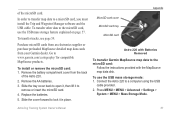
... > System > MENU > Mass Storage Mode.
Replace the batteries. 5.
Go to a computer using the USB
cable provided.
2. MicroSD card cover MicroSD card tray MicroSD card
Appendix
Astro 220 with Batteries Removed
To transfer Garmin MapSource map data to a microSD card, you must install the Trip and Waypoint Manager software and the USB cable. of the...
Owner's Manual - Page 64
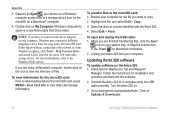
...Astro 220 software
To update software on .
3. For more information, refer to www.garmin.com/products/Astro. To transfer files to observe a new Removable Disk Drive listed. Unplug your Astro 220 from Windows Explorer, click Tools > Map... card: Prior to downloading data to the microSD card, press MENU > View Card Info to view the directory of files.
Connect the Astro 220 to a computer using...
Owner's Manual - Page 65
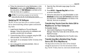
... Astro 220.
6. Turn the Astro 220 on Updates & Downloads. Go to MapSource on the Web site, there are no updates.)
Note: To avoid data corruption, do not turn the Astro 220 off or the DC 30 off during data transfer. Select the Tracks tab on ‑screen instructions.
7. Click Receive from Device from the Astro 220 to www.garmin.com/products/Astro...
Quick Start Manual - Page 1
....garmin.com for additional documentation and information.
© 2008 Garmin Ltd. The dog you are tracking is identified, and the dog pointer indicates the dog's direction from the Astro 220 ...page: Press MENU > MENU > Advanced > GPS Applications > Compass.
When you want to navigate >
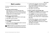
ENTER. 3. To find the location on the Map page, press MAP. Marking your Location
To mark your dog's ...
Similar Questions

How To Unlock Garmin Topo Maps For Astro 220
(Posted by KYL45jacks 9 years ago)

Kmz File Load In Custom Maps
i purchased montana 650t and now i load my kmz file to custom map folder but when i open my maps in ...
i purchased montana 650t and now i load my kmz file to custom map folder but when i open my maps in ...
(Posted by neilfrancisramil 9 years ago)
Does The Garmin Astro 220 Use Lake Maps
(Posted by mela179kopi 10 years ago)

I Can't Find Custom Map Enable/disable In The Setup Menu
I have GPSmap62s and I upload all my custom maps.kmz into custom maps folder but I couldn't find it ...
I have GPSmap62s and I upload all my custom maps.kmz into custom maps folder but I couldn't find it ...
(Posted by halaadel 11 years ago)

Garmin Astro 220 Dog Tracking System
can i use Garmin Astro 220 like a reg.standard gps would like to use when fishing in lake and the oc...
can i use Garmin Astro 220 like a reg.standard gps would like to use when fishing in lake and the oc...
(Posted by rayhubbard64 11 years ago)