
Owner's Manual
Page 4
...vi Important Information vi Getting Started 1 Unit Overview 1 Charging the GPSMAP 396 2 Turning On the GPSMAP 396 3 Getting Satellite Signals 4 Learning About the Keypad 7 Using the GPSMAP 396 8 Simulator Mode 11 Basic Operation In Aviation Mode 13 Aviation Mode Page Sequence 13 Creating a Direct To 14 Finding a ...62 Following an Automotive Route 65 Editing Your Route 66 Automotive Mode Pages and Features 68 Map Page 68 Highway Page 69 Current Route Page 71 Trip Computer 72 Editing and Managing Routes 73 Editing and Managing Waypoints 77 Managing Your Tracks 86 GPSMAP 396...
...vi Important Information vi Getting Started 1 Unit Overview 1 Charging the GPSMAP 396 2 Turning On the GPSMAP 396 3 Getting Satellite Signals 4 Learning About the Keypad 7 Using the GPSMAP 396 8 Simulator Mode 11 Basic Operation In Aviation Mode 13 Aviation Mode Page Sequence 13 Creating a Direct To 14 Finding a ...62 Following an Automotive Route 65 Editing Your Route 66 Automotive Mode Pages and Features 68 Map Page 68 Highway Page 69 Current Route Page 71 Trip Computer 72 Editing and Managing Routes 73 Editing and Managing Waypoints 77 Managing Your Tracks 86 GPSMAP 396...

Owner's Manual
Page 70
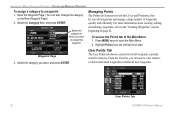
...new waypoint's location coordinates manually. To mark your changes, highlight OK, and press Enter. 62 GPSMAP 396 Owner's Manual New Waypoint Page 2. After entering and confirming your present location: 1. The GPSMAP 396 stores up to 3,000 alphanumeric waypoints with the default information, use the ROCKER to highlight ... find waypoints using the ROCKER. • Text Entry-allows you to mark your current location as a waypoint by looking at the GPS tab on the New Waypoint Page, highlight the appropriate field, and press Enter. To accept the waypoint with a user-defined icon,...
...new waypoint's location coordinates manually. To mark your changes, highlight OK, and press Enter. 62 GPSMAP 396 Owner's Manual New Waypoint Page 2. After entering and confirming your present location: 1. The GPSMAP 396 stores up to 3,000 alphanumeric waypoints with the default information, use the ROCKER to highlight ... find waypoints using the ROCKER. • Text Entry-allows you to mark your current location as a waypoint by looking at the GPS tab on the New Waypoint Page, highlight the appropriate field, and press Enter. To accept the waypoint with a user-defined icon,...
Owner's Manual
Page 90
... Points tab features two sub tabs, User and Proximity, that let you can also change the category on page 62. To access the Points tab of all user waypoints. User Points Tab 82 GPSMAP 396 Owner's Manual Select the category to which you want to the "Creating Waypoints" section beginning on the New...
... Points tab features two sub tabs, User and Proximity, that let you can also change the category on page 62. To access the Points tab of all user waypoints. User Points Tab 82 GPSMAP 396 Owner's Manual Select the category to which you want to the "Creating Waypoints" section beginning on the New...

Owner's Manual
Page 111
For more information about waypoints, see the "Managing Your Tracks" section beginning on page 62. Proximity Sub Tab Use the Proximity sub tab to manage a large number of waypoints quickly and efficiently. User Sub Tab The User sub tab shows a ..." section beginning on page 86. The total number of stored and available waypoints appears at the bottom of all waypoints currently stored in your unit. GPSMAP 396 Owner's Manual 103
For more information about waypoints, see the "Managing Your Tracks" section beginning on page 62. Proximity Sub Tab Use the Proximity sub tab to manage a large number of waypoints quickly and efficiently. User Sub Tab The User sub tab shows a ..." section beginning on page 86. The total number of stored and available waypoints appears at the bottom of all waypoints currently stored in your unit. GPSMAP 396 Owner's Manual 103

Owner's Manual
Page 187
.... Index Index Symbols 2D 5, 62, 142 3D 5, 62 A accessories 156 acquiring satellites 5 Active Route page aviation mode 43 Active Track tab 86, 89 add to steer 33 criteria 21 cruising speed 46 Current Route page 65, 71 custom avoids 66, 117 D dashboard 72 data, entering 9, 10 data card 160 GPSMAP 396 Owner's Manual 179 See...
.... Index Index Symbols 2D 5, 62, 142 3D 5, 62 A accessories 156 acquiring satellites 5 Active Route page aviation mode 43 Active Track tab 86, 89 add to steer 33 criteria 21 cruising speed 46 Current Route page 65, 71 custom avoids 66, 117 D dashboard 72 data, entering 9, 10 data card 160 GPSMAP 396 Owner's Manual 179 See...

Owner's Manual
Page 190
...view details 30 VNAV 41, 42 indicator 41 profile 41 volume 3, 114 VOR 17, 169 GPSMAP 396 Owner's Manual Index route tab 73 RTCM 122, 123 runway criteria 21 S safety and product... racing timer 94 satellite signals 3, 4-6 saved route 26, 73 saved track 89 save present location 62 scan for a frequency 122 search history 58 sentences 124, 161 serial communications port 159 serial data... system alarms 106 System tab 115 T temperature 119, 145 terrain alert 27 Terrain Page aviation mode 36-38 declutter 32 terrain warning 37 text language 115 thermoclines 144 tide chart 110...
...view details 30 VNAV 41, 42 indicator 41 profile 41 volume 3, 114 VOR 17, 169 GPSMAP 396 Owner's Manual Index route tab 73 RTCM 122, 123 runway criteria 21 S safety and product... racing timer 94 satellite signals 3, 4-6 saved route 26, 73 saved track 89 save present location 62 scan for a frequency 122 search history 58 sentences 124, 161 serial communications port 159 serial data... system alarms 106 System tab 115 T temperature 119, 145 terrain alert 27 Terrain Page aviation mode 36-38 declutter 32 terrain warning 37 text language 115 thermoclines 144 tide chart 110...

Owner's Manual
Page 191
...XM WX Weather 126 additional information 131 finding weather information 132 options 126 radio ID 131 viewing 125 X symbol on terrain 36 Z zoom 29 GPSMAP 396 Owner's Manual 183 Index W WAAS 6, 115, 157, 162, 163 Warning Page 3 waterproof 155 water speed, calibrate 140 water temp 107 waypoint 15,... create 25, 63, 80 deleting 84 edit 77, 78 editing 77, 78 Information Page 59 manage 77 managing 77 mark 25 marking 25, 62, 63, 64, 80 marking underwater 138 name 78 projecting 80 proximity 85 symbol 78 transition 73 weather information finding 132 Weather tab 129 options menu...
...XM WX Weather 126 additional information 131 finding weather information 132 options 126 radio ID 131 viewing 125 X symbol on terrain 36 Z zoom 29 GPSMAP 396 Owner's Manual 183 Index W WAAS 6, 115, 157, 162, 163 Warning Page 3 waterproof 155 water speed, calibrate 140 water temp 107 waypoint 15,... create 25, 63, 80 deleting 84 edit 77, 78 editing 77, 78 Information Page 59 manage 77 managing 77 mark 25 marking 25, 62, 63, 64, 80 marking underwater 138 name 78 projecting 80 proximity 85 symbol 78 transition 73 weather information finding 132 Weather tab 129 options menu...


