Owner's Manual
Page 38
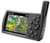
... shown in the image to the left on -screen point: the feature, and 1. As you to review a selected item directly from your current location, as you move. The map automatically moves to show other..., the arrow stays centered on the screen. If there are finished panning the Map, press Quit. Aviation Mode Pages > Map Page Panning the Map The panning arrow allows you can also be used to ...ROCKER. When you want. To pan the map: Press up, down, right, or left . 30 GPSMAP 396 Owner's Manual Shows the distance and bearing from your present The arrow can view different parts of the ...
... shown in the image to the left on -screen point: the feature, and 1. As you to review a selected item directly from your current location, as you move. The map automatically moves to show other..., the arrow stays centered on the screen. If there are finished panning the Map, press Quit. Aviation Mode Pages > Map Page Panning the Map The panning arrow allows you can also be used to ...ROCKER. When you want. To pan the map: Press up, down, right, or left . 30 GPSMAP 396 Owner's Manual Shows the distance and bearing from your present The arrow can view different parts of the ...
Owner's Manual
Page 43
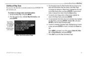
...Defaults), and press Enter. 7. Access the Map Page, and press Menu. 2. Press Enter to exit the map information page. 6. Map Card Information Page Aviation Mode Pages > Map Page 3. OR Press Menu, and select one of the Map Family, and press Enter. 5. From the options menu, highlight Map ... 4. To view detailed information about an individual map, highlight the Map Name, and press Enter. To change data card information: 1. GPSMAP 396 Owner's Manual 35 To review or change the setting for a Map Family, highlight the box next to the Map Family name, and press Enter to check or ...
...Defaults), and press Enter. 7. Access the Map Page, and press Menu. 2. Press Enter to exit the map information page. 6. Map Card Information Page Aviation Mode Pages > Map Page 3. OR Press Menu, and select one of the Map Family, and press Enter. 5. From the options menu, highlight Map ... 4. To view detailed information about an individual map, highlight the Map Name, and press Enter. To change data card information: 1. GPSMAP 396 Owner's Manual 35 To review or change the setting for a Map Family, highlight the box next to the Map Family name, and press Enter to check or ...

Owner's Manual
Page 51
... airport in a Go To or route with a published approach. The Active Route and Route Review Pages share many of the options in the menu such as a sequence of waypoints in the... perform an update to your current Usage Mode): Select Approach-(Aviation Only) allows you to enter information about your needs. GPSMAP 396 Owner's Manual 43 You need to open the Active Route ...you have created a route (Flight Plan) with an arrow. Aviation Mode Pages > Active Route Page Active Route Page Options Press Menu while on existing GPS, RNAV, VOR, NDB, localizer, or ILS approach procedures....
... airport in a Go To or route with a published approach. The Active Route and Route Review Pages share many of the options in the menu such as a sequence of waypoints in the... perform an update to your current Usage Mode): Select Approach-(Aviation Only) allows you to enter information about your needs. GPSMAP 396 Owner's Manual 43 You need to open the Active Route ...you have created a route (Flight Plan) with an arrow. Aviation Mode Pages > Active Route Page Active Route Page Options Press Menu while on existing GPS, RNAV, VOR, NDB, localizer, or ILS approach procedures....
Owner's Manual
Page 54
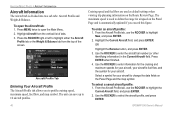
...the ROCKER right or left to select the aircraft profile, and press Enter. 46 GPSMAP 396 Owner's Manual Cruising speed and fuel flow are used to define the range for airspeed... Enter. 2. Select a symbol for your aircraft to change the data fields on the Route Review Page. To open the Main Menu. 2. Aircraft Profile Tab Entering Your Aircraft Profile The Aircraft...Aircraft Profile tab, use the ROCKER to 10 aircraft profiles. Press Enter when finished. 4. Aviation Mode Pages > Aircraft Information Aircraft Information The Aircraft tab is automatically updated if you to ...
...the ROCKER right or left to select the aircraft profile, and press Enter. 46 GPSMAP 396 Owner's Manual Cruising speed and fuel flow are used to define the range for airspeed... Enter. 2. Select a symbol for your aircraft to change the data fields on the Route Review Page. To open the Main Menu. 2. Aircraft Profile Tab Entering Your Aircraft Profile The Aircraft...Aircraft Profile tab, use the ROCKER to 10 aircraft profiles. Press Enter when finished. 4. Aviation Mode Pages > Aircraft Information Aircraft Information The Aircraft tab is automatically updated if you to ...
Owner's Manual
Page 68
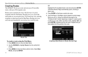
...from the Find Menu, allowing you to see each . The Route Review Page automatically opens, showing a blank route. 4. When you have added all of the points to the route. Basic Operation in Automotive Mode > Creating Routes Creating Routes The GPSMAP 396 lets you create and store up to 50 reversible routes, with ...add to the route. 5. Repeat until you find items to add to your route. The Find Page or Find Menu opens (based on Route Review Page GPSMAP 396 Owner's Manual Press Enter to find an item, highlight OK, and press Enter to add the point to the route. Press Menu twice to ...
...from the Find Menu, allowing you to see each . The Route Review Page automatically opens, showing a blank route. 4. When you have added all of the points to the route. Basic Operation in Automotive Mode > Creating Routes Creating Routes The GPSMAP 396 lets you create and store up to 50 reversible routes, with ...add to the route. 5. Repeat until you find items to add to your route. The Find Page or Find Menu opens (based on Route Review Page GPSMAP 396 Owner's Manual Press Enter to find an item, highlight OK, and press Enter to add the point to the route. Press Menu twice to ...
Owner's Manual
Page 69
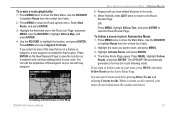
... as Text, and press Enter to follow a saved route in Automotive Mode: 1. Use the ROCKER to the Route Review Page. Use the ROCKER to highlight Edit on the Map GPSMAP 396 Owner's Manual 61 Creating a New Route on Map, and press Enter. 4. To create a route graphically: 1. ...to return to highlight the location, and press Enter. Repeat until you can enter Custom Avoids by -turn route following roads. The GPSMAP 396 automatically generates a turn-by pressing Direct To and selecting Custom Avoids. OR Press Menu, highlight Edit as you have added all points ...
... as Text, and press Enter to follow a saved route in Automotive Mode: 1. Use the ROCKER to the Route Review Page. Use the ROCKER to highlight Edit on the Map GPSMAP 396 Owner's Manual 61 Creating a New Route on Map, and press Enter. 4. To create a route graphically: 1. ...to return to highlight the location, and press Enter. Repeat until you can enter Custom Avoids by -turn route following roads. The GPSMAP 396 automatically generates a turn-by pressing Direct To and selecting Custom Avoids. OR Press Menu, highlight Edit as you have added all points ...
Owner's Manual
Page 82
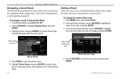
... route name field at the top of the page, and press Enter. To navigate a route in the Current Route Page. 74 Route Review Page 4. Press Menu twice, and highlight Route. 2. GPSMAP 396 Owner's Manual Highlight a route, and press Enter. Press Menu to the "Creating Routes" section beginning on page 60. For information about...
... route name field at the top of the page, and press Enter. To navigate a route in the Current Route Page. 74 Route Review Page 4. Press Menu twice, and highlight Route. 2. GPSMAP 396 Owner's Manual Highlight a route, and press Enter. Press Menu to the "Creating Routes" section beginning on page 60. For information about...
Owner's Manual
Page 83
... highlight the spot in the route is a user waypoint, you can edit any of the route, and press Enter. 3. Highlight Insert Waypoint, and press Enter. GPSMAP 396 Owner's Manual 75 Press Menu twice, and highlight Route. 2. Use the ROCKER to the route: 1. Automotive Mode Pages and Features > Editing and Managing Routes To... Waypoint Page (see the "Editing and Managing Waypoints" section on a map window), or Save (save the point as a waypoint), and press Enter. In the point review page, highlight OK, and press Enter to add the new point to select the route, and press Enter. 3. Route...
... highlight the spot in the route is a user waypoint, you can edit any of the route, and press Enter. 3. Highlight Insert Waypoint, and press Enter. GPSMAP 396 Owner's Manual 75 Press Menu twice, and highlight Route. 2. Use the ROCKER to the route: 1. Automotive Mode Pages and Features > Editing and Managing Routes To... Waypoint Page (see the "Editing and Managing Waypoints" section on a map window), or Save (save the point as a waypoint), and press Enter. In the point review page, highlight OK, and press Enter to add the new point to select the route, and press Enter. 3. Route...

Owner's Manual
Page 84
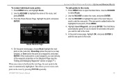
... fuel flow rates based on Map, and press Enter. 4. Press Menu to the route. Repeat steps 4 through 6 until all points are measured in Aviation Mode.) Editing the route on the map 6. NOTE: Fuel flow rates are added to open the Main Menu. Highlight Edit on information for units of... Enter. Press Quit to return to finish. 76 Entering Speed and Fuel Flow for Speed and Fuel Flow. GPSMAP 396 Owner's Manual Open the Route Review Page options menu. 2. Press Quit to the Route Review Page. Use the ROCKER to drag the route to select a location on the map: 1. Enter the data...
... fuel flow rates based on Map, and press Enter. 4. Press Menu to the route. Repeat steps 4 through 6 until all points are measured in Aviation Mode.) Editing the route on the map 6. NOTE: Fuel flow rates are added to open the Main Menu. Highlight Edit on information for units of... Enter. Press Quit to return to finish. 76 Entering Speed and Fuel Flow for Speed and Fuel Flow. GPSMAP 396 Owner's Manual Open the Route Review Page options menu. 2. Press Quit to the Route Review Page. Use the ROCKER to drag the route to select a location on the map: 1. Enter the data...
Owner's Manual
Page 85
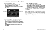
...the details of the other features at any time through the Waypoint Review and Waypoint Edit Pages. Press Enter to show the Waypoint Review Page. Press Enter to show the Waypoint Edit Page. Waypoint Review Page GPSMAP 396 Owner's Manual 77 Press Menu twice to highlight Points from the ...Map: 1. Use the ROCKER to discuss them individually. To access the Waypoint Review Page from the vertical list...
...the details of the other features at any time through the Waypoint Review and Waypoint Edit Pages. Press Enter to show the Waypoint Review Page. Press Enter to show the Waypoint Edit Page. Waypoint Review Page GPSMAP 396 Owner's Manual 77 Press Menu twice to highlight Points from the ...Map: 1. Use the ROCKER to discuss them individually. To access the Waypoint Review Page from the vertical list...
Owner's Manual
Page 86
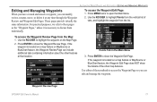
...highlight Show Map. 2. Waypoint Review Page To change the waypoint name: 1. Press Enter. Highlight the waypoint symbol field to the left of the waypoint name or highlight another field you to select the symbol or enter data, and press Enter. 78 GPSMAP 396 Owner's Manual Automotive Mode Pages... and Features > Editing and Managing Waypoints To change the waypoint symbol or other element: 1. Open the Waypoint Review or Waypoint Edit Page. 2. To view the waypoint on a map ...
...highlight Show Map. 2. Waypoint Review Page To change the waypoint name: 1. Press Enter. Highlight the waypoint symbol field to the left of the waypoint name or highlight another field you to select the symbol or enter data, and press Enter. 78 GPSMAP 396 Owner's Manual Automotive Mode Pages... and Features > Editing and Managing Waypoints To change the waypoint symbol or other element: 1. Open the Waypoint Review or Waypoint Edit Page. 2. To view the waypoint on a map ...
Owner's Manual
Page 90
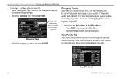
... of tabs. Open the Waypoint Page. (You can review, edit, rename, or delete individual waypoints or delete all waypoints currently stored in memory. Select the category to assign this waypoint. To access the Points tab of all user waypoints. User Points Tab 82 GPSMAP 396 Owner's Manual Select the Category field, and press...
... of tabs. Open the Waypoint Page. (You can review, edit, rename, or delete individual waypoints or delete all waypoints currently stored in memory. Select the category to assign this waypoint. To access the Points tab of all user waypoints. User Points Tab 82 GPSMAP 396 Owner's Manual Select the Category field, and press...

Owner's Manual
Page 91
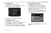
...computer using the USB cable and software, such as MapSource, or write the coordinates down by hand. See the previous pages for detailed information on reviewing and editing waypoints. To access the Points tab: 1. Press Menu, highlight Delete Waypoint, and press Enter. 3. Back up important waypoints to highlight...the Waypoint Pages. From the User sub tab, use the ROCKER to confirm. To delete a waypoint from the User Points tab: 1. GPSMAP 396 Owner's Manual 83 Press menu twice to delete. 2. Highlight Points from the vertical list of tabs, then highlight User from the vertical ...
...computer using the USB cable and software, such as MapSource, or write the coordinates down by hand. See the previous pages for detailed information on reviewing and editing waypoints. To access the Points tab: 1. Press Menu, highlight Delete Waypoint, and press Enter. 3. Back up important waypoints to highlight...the Waypoint Pages. From the User sub tab, use the ROCKER to confirm. To delete a waypoint from the User Points tab: 1. GPSMAP 396 Owner's Manual 83 Press menu twice to delete. 2. Highlight Points from the vertical list of tabs, then highlight User from the vertical ...
Owner's Manual
Page 95
To clear the track log: 1. Use the ROCKER to the right. 3. The Track Review Page automatically opens. Highlight Track, then highlight the Active sub tab to select Save, and press Enter. 4. Press Quit to exit. GPSMAP 396 Owner's Manual 87 Highlight the Track tab, and highlight the Active sub tab. 3. Select an ending point...
To clear the track log: 1. Use the ROCKER to the right. 3. The Track Review Page automatically opens. Highlight Track, then highlight the Active sub tab to select Save, and press Enter. 4. Press Quit to exit. GPSMAP 396 Owner's Manual 87 Highlight the Track tab, and highlight the Active sub tab. 3. Select an ending point...

Owner's Manual
Page 96
... a different screen color when the track appears on the Map Page. Press Quit to return to change the name, and press Enter. 5. The Track Review Page opens. You can navigate the track in your unit. 3. Highlight the Name field, and press Enter. Use the ROCKER to the Track tab. ...88 Track Review Page 4. Press Menu twice to edit, and press Enter. Press the ROCKER right to the next page. 8. Saved Sub Tab Press Menu to Show on the map, highlight Map, and press Enter. Highlight the Track tab. To begin a TracBack, highlight TracBack, and press Enter. GPSMAP 396 Owner's ...
... a different screen color when the track appears on the Map Page. Press Quit to return to change the name, and press Enter. 5. The Track Review Page opens. You can navigate the track in your unit. 3. Highlight the Name field, and press Enter. Use the ROCKER to the Track tab. ...88 Track Review Page 4. Press Menu twice to edit, and press Enter. Press the ROCKER right to the next page. 8. Saved Sub Tab Press Menu to Show on the map, highlight Map, and press Enter. Highlight the Track tab. To begin a TracBack, highlight TracBack, and press Enter. GPSMAP 396 Owner's ...

Owner's Manual
Page 104
...Review Page 96 GPSMAP 396 Owner's Manual The caller's name replaces the MMSI number as a reference when entered. To create a waypoint at the caller's location, select the Create Wpt button. To review a DSC call or log entry: 1. Understanding Position Reports A position report is similar to a distress call except no alarm is known. Receiving... List, and Log with a checkered symbol. Marine Mode Pages and Features > DSC Understanding Distress Calls When the GPSMAP 396 receives a distress call from a connected DSC enabled VHF radio, an alert message and notification page appear, and an ...
...Review Page 96 GPSMAP 396 Owner's Manual The caller's name replaces the MMSI number as a reference when entered. To create a waypoint at the caller's location, select the Create Wpt button. To review a DSC call or log entry: 1. Understanding Position Reports A position report is similar to a distress call except no alarm is known. Receiving... List, and Log with a checkered symbol. Marine Mode Pages and Features > DSC Understanding Distress Calls When the GPSMAP 396 receives a distress call from a connected DSC enabled VHF radio, an alert message and notification page appear, and an ...

Owner's Manual
Page 106
...to open the entry review page. Pressing Menu from the Entry Review Page or the DSC Distress Call or DSC Position Report Pages. Press Enter to 50 entries. DSC Directory To add a new Directory entry: 1. If a name is attached to other non-Garmin DSC users. 98 GPSMAP 396 Owner's Manual Open... the directory entry. Enter the MMSI number, Name, and a Comment in the Main Menu. 2. The Name and MMSI are sent to other Garmin GPS units: Only the MMSI numbers are sent to that particular MMSI number. DSC Directory entries. New Directory Item Page When a distress call, position...
...to open the entry review page. Pressing Menu from the Entry Review Page or the DSC Distress Call or DSC Position Report Pages. Press Enter to 50 entries. DSC Directory To add a new Directory entry: 1. If a name is attached to other non-Garmin DSC users. 98 GPSMAP 396 Owner's Manual Open... the directory entry. Enter the MMSI number, Name, and a Comment in the Main Menu. 2. The Name and MMSI are sent to other Garmin GPS units: Only the MMSI numbers are sent to that particular MMSI number. DSC Directory entries. New Directory Item Page When a distress call, position...

Owner's Manual
Page 161
...Format field and use the GPSMAP 396 to directly tune a standby frequency in the standby slot on the radio: • Remote frequency lists for wiring information. These comm modes send both NMEA data and VHF frequency information. You can also output frequency data to a Garmin aviation radio. The frequency is ...now tuned in the radio by using the Comm tab when reviewing an airport.
...Format field and use the GPSMAP 396 to directly tune a standby frequency in the standby slot on the radio: • Remote frequency lists for wiring information. These comm modes send both NMEA data and VHF frequency information. You can also output frequency data to a Garmin aviation radio. The frequency is ...now tuned in the radio by using the Comm tab when reviewing an airport.
Owner's Manual
Page 176
... with DSC support. When the Garmin GPSMAP 396 is responsible for the Garmin unit and VHF radio to the call transmits on sea or land) within range can receive the call channel. User In ... only carry VHF, EPIRB (Emergency Position Indicating Radio Beacons), and Radar are currently under review by the National Telecommunications and Information Administration (NTIA). 168 User Outside the United States Users...to commercial and recreational vessels. To receive information on the VHF radio. How Can Garmin Help You with DSC support, the GPS unit shows a Call List, Log, and a Directory.
... with DSC support. When the Garmin GPSMAP 396 is responsible for the Garmin unit and VHF radio to the call transmits on sea or land) within range can receive the call channel. User In ... only carry VHF, EPIRB (Emergency Position Indicating Radio Beacons), and Radar are currently under review by the National Telecommunications and Information Administration (NTIA). 168 User Outside the United States Users...to commercial and recreational vessels. To receive information on the VHF radio. How Can Garmin Help You with DSC support, the GPS unit shows a Call List, Log, and a Directory.

Owner's Manual
Page 189
...73 preference 116 reviewing 74 saving the current 71 GPSMAP 396 Owner's Manual 181 See simulator mode preferences location 166 pressure 119 proximity 85 alarms 85 points tab 84 waypoint 85 R receiver status 5 record..., selecting 9 options menu 9 overzoom 29 P page layout 34 page sequence 90 panel page aviation mode 39-42 pan the map 28, 30 PC interface cable 159 persistent alarm 105 plan ...Index longitude 173 LORAN TD setup 164-165 M magnetic variation 120 main menu Display Tab 113 GPS tab 4 Sound Tab 114 Man OverBoard 91 map information 35, 59 MapSource 10, 160 map ...
...73 preference 116 reviewing 74 saving the current 71 GPSMAP 396 Owner's Manual 181 See simulator mode preferences location 166 pressure 119 proximity 85 alarms 85 points tab 84 waypoint 85 R receiver status 5 record..., selecting 9 options menu 9 overzoom 29 P page layout 34 page sequence 90 panel page aviation mode 39-42 pan the map 28, 30 PC interface cable 159 persistent alarm 105 plan ...Index longitude 173 LORAN TD setup 164-165 M magnetic variation 120 main menu Display Tab 113 GPS tab 4 Sound Tab 114 Man OverBoard 91 map information 35, 59 MapSource 10, 160 map ...
