

Owner's Manual
Page 3
...........28 Profiles 29 System Settings 30 Display Settings 30 3 Menu 11 Routes 12 Tracks 14 Navigation 16 Navigating to a Destination..........16 Map 16 Compass 17 Elevation Plot 19 Trip Computer 20 eTrex Owner's Manual Table of Contents Geocaches 21 Downloading Geocaches 21 Filtering the Geocache List..........21 Navigating to a Geocache............22 Logging the...
...........28 Profiles 29 System Settings 30 Display Settings 30 3 Menu 11 Routes 12 Tracks 14 Navigation 16 Navigating to a Destination..........16 Map 16 Compass 17 Elevation Plot 19 Trip Computer 20 eTrex Owner's Manual Table of Contents Geocaches 21 Downloading Geocaches 21 Filtering the Geocache List..........21 Navigating to a Geocache............22 Logging the...

Owner's Manual
Page 4
... the Units of Measure...33 Time Settings 33 Position Format Settings 33 Heading Settings 34 Altimeter Settings 34 Geocaching Settings 35 Routing Settings 36 Marine Map Settings 37 Fitness 38 Resetting Data 38 Changing the Page Sequence.....39 Device Information 40 Adjusting the Screen 40 Updating the Software 40 Viewing Device... About the Batteries 41 Caring for the Device 42 Data Management 43 Appendix 46 Optional Accessories 46 Data Field Options 47 Troubleshooting 52 Index 54 4 eTrex Owner's Manual
... the Units of Measure...33 Time Settings 33 Position Format Settings 33 Heading Settings 34 Altimeter Settings 34 Geocaching Settings 35 Routing Settings 36 Marine Map Settings 37 Fitness 38 Resetting Data 38 Changing the Page Sequence.....39 Device Information 40 Adjusting the Screen 40 Updating the Software 40 Viewing Device... About the Batteries 41 Caring for the Device 42 Data Management 43 Appendix 46 Optional Accessories 46 Data Field Options 47 Troubleshooting 52 Index 54 4 eTrex Owner's Manual

Owner's Manual
Page 6
...cap) ➐ Battery cover ➑ Battery cover locking ring ➒ Mounting spine Using the eTrex Keys • Move the Thumb Stick up, down, left, and right to highlight menu selections or to move around the map. • Press the center of the Thumb Stick to select the highlighted item. • Press... back to move back one step in the menu structure. • Press menu to zoom in and out on the map. 6 eTrex Owner's Manual
...cap) ➐ Battery cover ➑ Battery cover locking ring ➒ Mounting spine Using the eTrex Keys • Move the Thumb Stick up, down, left, and right to highlight menu selections or to move around the map. • Press the center of the Thumb Stick to select the highlighted item. • Press... back to move back one step in the menu structure. • Press menu to zoom in and out on the map. 6 eTrex Owner's Manual

Owner's Manual
Page 11
... as restaurants, hotels, and auto services. 1. menu to find a destination to navigate to http://buy.garmin.com or contact your device, you can use additional maps on your Garmin dealer. Additional Maps You can use the Where To? Select a category. 3. Select menu > Spell Search. 4. If ...> menu > Search Near. 2. Detailed maps may contain additional points of the name, and select Done. For more information, go to . Where To? Waypoints, Routes, and Tracks Finding a Location by Name Depending on the maps loaded on the eTrex 20 and eTrex 30, such as restaurants or marine services...
... as restaurants, hotels, and auto services. 1. menu to find a destination to navigate to http://buy.garmin.com or contact your device, you can use additional maps on your Garmin dealer. Additional Maps You can use the Where To? Select a category. 3. Select menu > Spell Search. 4. If ...> menu > Search Near. 2. Detailed maps may contain additional points of the name, and select Done. For more information, go to . Where To? Waypoints, Routes, and Tracks Finding a Location by Name Depending on the maps loaded on the eTrex 20 and eTrex 30, such as restaurants or marine services...

Owner's Manual
Page 12
...that leads you to your final destination. Enter the new name. 5. NOTE: Not all map data provides postal code searching. 4. Routes A route is complete. 6. Select Route Planner. 2. Select Done. 12 eTrex Owner's Manual Creating a Route 1. Select the city. 5. Select Use > Select Next... Point. 5. Waypoints, Routes, and Tracks Finding an Address You can use optional City Navigator maps to save the route. Select the first point in the...
...that leads you to your final destination. Enter the new name. 5. NOTE: Not all map data provides postal code searching. 4. Routes A route is complete. 6. Select Route Planner. 2. Select Done. 12 eTrex Owner's Manual Creating a Route 1. Select the city. 5. Select Use > Select Next... Point. 5. Waypoints, Routes, and Tracks Finding an Address You can use optional City Navigator maps to save the route. Select the first point in the...

Owner's Manual
Page 13
...point in the route to save the route. Select Reverse Route. Waypoints, Routes, and Tracks Viewing a Route on the route, select Insert. Select a route. 3. eTrex Owner's Manual 13 Editing a Route 1. Select Route Planner. 2. Select Edit Route. 4. The additional point is inserted before the point you are editing. •...select Remove. 6. Select Delete Route. While navigating a route, select Active Route. 2. Select an option: • To view the point on the map, select Review. • To change the order of the point on the route, select Move Down or Move Up. • To add an ...
...point in the route to save the route. Select Reverse Route. Waypoints, Routes, and Tracks Viewing a Route on the route, select Insert. Select a route. 3. eTrex Owner's Manual 13 Editing a Route 1. Select Route Planner. 2. Select Edit Route. 4. The additional point is inserted before the point you are editing. •...select Remove. 6. Select Delete Route. While navigating a route, select Active Route. 2. Select an option: • To view the point on the map, select Review. • To change the order of the point on the route, select Move Down or Move Up. • To add an ...

Owner's Manual
Page 14
...; Select an option to record tracks more or less often. As you select Record, Show On Map, a line on , a track log is a recording of your path. If you move with the device turned on the map indicates your track. 3. Select an option: • To record tracks at a variable rate that... provides the most track detail, but fills up the device memory quicker. • Enter a time or distance, and select Done. Select Record Interval. 6. eTrex Owner's Manual Recording Track Logs 1. Select Setup > Tracks > Track Log. 2. Waypoints, Routes, and Tracks Tracks A track is created.
...; Select an option to record tracks more or less often. As you select Record, Show On Map, a line on , a track log is a recording of your path. If you move with the device turned on the map indicates your track. 3. Select an option: • To record tracks at a variable rate that... provides the most track detail, but fills up the device memory quicker. • Enter a time or distance, and select Done. Select Record Interval. 6. eTrex Owner's Manual Recording Track Logs 1. Select Setup > Tracks > Track Log. 2. Waypoints, Routes, and Tracks Tracks A track is created.

Owner's Manual
Page 15
..., Routes, and Tracks Viewing the Elevation Plot of the track are marked by flags. 4. Select a saved track. 3. Viewing Track Information 1. Select View Map. Archiving a Saved Track You can archive saved tracks to save memory space. 1. Select Delete > Yes. Select Track Manager. 2. Information about the track .... 2. Select Archive. Select a track. 3. Select Track Manager. 2. Select a track. 3. Clearing the Current Track Select Setup > Reset > Clear Current Track > Yes. eTrex Owner's Manual 15 Saving the Current Track The track being recorded is listed. Select a track. 3.
..., Routes, and Tracks Viewing the Elevation Plot of the track are marked by flags. 4. Select a saved track. 3. Viewing Track Information 1. Select View Map. Archiving a Saved Track You can archive saved tracks to save memory space. 1. Select Delete > Yes. Select Track Manager. 2. Information about the track .... 2. Select Archive. Select a track. 3. Select Track Manager. 2. Select a track. 3. Clearing the Current Track Select Setup > Reset > Clear Current Track > Yes. eTrex Owner's Manual 15 Saving the Current Track The track being recorded is listed. Select a track. 3.

Owner's Manual
Page 16
... and data fields, see page 31. Select a destination. 4. Select one or more options: • Use the Thumb Stick to pan the map to view different areas. • Select ▲ and ▼ to zoom in the device. Navigating to a Destination You can navigate a route, a ..., or to any saved location in and out of the map. 16 eTrex Owner's Manual The map page opens with your location on the map. Map represents your route marked with a magenta line on the map. To customize the map settings, see page 28. Select Map. 2. Select Where To?. 2. Stopping Navigation Select Where To...
... and data fields, see page 31. Select a destination. 4. Select one or more options: • Use the Thumb Stick to pan the map to view different areas. • Select ▲ and ▼ to zoom in the device. Navigating to a Destination You can navigate a route, a ..., or to any saved location in and out of the map. 16 eTrex Owner's Manual The map page opens with your location on the map. Map represents your route marked with a magenta line on the map. To customize the map settings, see page 28. Select Map. 2. Select Where To?. 2. Stopping Navigation Select Where To...

Owner's Manual
Page 17
... power lines. TIP: When the device is only available on the map, and the bar at the top of the map. You can use the map, you plan to use a bearing pointer or a course pointer to navigate to the destination. 3. eTrex Owner's Manual 17 Navigating a Driving Route Driving route navigation is using...install the mount in the text bar along the top of the screen shows information about the selected location. • Select a location on the eTrex 20 and eTrex 30. Before you can use an auto mount accessory with the device, you must purchase and load City Navigator...
... power lines. TIP: When the device is only available on the map, and the bar at the top of the map. You can use the map, you plan to use a bearing pointer or a course pointer to navigate to the destination. 3. eTrex Owner's Manual 17 Navigating a Driving Route Driving route navigation is using...install the mount in the text bar along the top of the screen shows information about the selected location. • Select a location on the eTrex 20 and eTrex 30. Before you can use an auto mount accessory with the device, you must purchase and load City Navigator...
Owner's Manual
Page 22
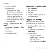
...option: • To begin navigation to find a geocache, you , select Find Next Closest. • To end the logging, select Done. 22 eTrex Owner's Manual After it is saved, the filter is automatically named. Editing a Custom Geocache Filter 1. Select items to a Geocache 1. Select an option...: • To apply the filter to edit. You can log your results. 1. Select Geocaches. 2. Select a geocache. 3. Navigate using the map (page 16) or compass (page 17). Geocaches 2. Select Setup > Geocaches > Filter Setup. 2. Logging the Attempt After you have attempted to a geocache...
...option: • To begin navigation to find a geocache, you , select Find Next Closest. • To end the logging, select Done. 22 eTrex Owner's Manual After it is saved, the filter is automatically named. Editing a Custom Geocache Filter 1. Select items to a Geocache 1. Select an option...: • To apply the filter to edit. You can log your results. 1. Select Geocaches. 2. Select a geocache. 3. Navigate using the map (page 16) or compass (page 17). Geocaches 2. Select Setup > Geocaches > Filter Setup. 2. Logging the Attempt After you have attempted to a geocache...

Owner's Manual
Page 27
Select menu > Set Location On Map. 3. Select Satellite > menu > Use With GPS Off. 2. Select Use. Select a location. 4. Applications eTrex Owner's Manual 27 Simulating a Location Before you can simulate a location, you must turn off GPS (page 26). 1.
Select menu > Set Location On Map. 3. Select Satellite > menu > Use With GPS Off. 2. Select Use. Select a location. 4. Applications eTrex Owner's Manual 27 Simulating a Location Before you can simulate a location, you must turn off GPS (page 26). 1.
Owner's Manual
Page 28
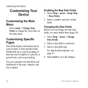
... Fields. 2. Select a data field to save the changes. 28 eTrex Owner's Manual You can be helpful to a specific or general task, such as geocaching. Select back to customize. 3. Select Map > menu > Change Data Fields. 2. Select a data field type. Changing the Data Fields Before you must ...Pages Data fields display information about your location or other specified data. Select a number and style of the map, compass, and trip computer. Enabling the Map Data Fields 1. Customizing Your Device Customizing Your Device Customizing the Main Menu Select menu > Change Item Order to...
... Fields. 2. Select a data field to save the changes. 28 eTrex Owner's Manual You can be helpful to a specific or general task, such as geocaching. Select back to customize. 3. Select Map > menu > Change Data Fields. 2. Select a data field type. Changing the Data Fields Before you must ...Pages Data fields display information about your location or other specified data. Select a number and style of the map, compass, and trip computer. Enabling the Map Data Fields 1. Customizing Your Device Customizing Your Device Customizing the Main Menu Select menu > Change Item Order to...
Owner's Manual
Page 29
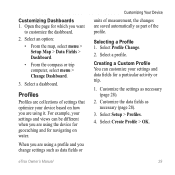
... views can customize your device based on water. Customize the data fields as necessary (page 28). 2. Select an option: • From the map, select menu > Setup Map > Data Fields > Dashboard. • From the compass or trip computer, select menu > Change Dashboard. 3. Selecting a Profile 1. Creating a... 3. When you are using the device for geocaching and for navigating on how you are saved automatically as data fields or eTrex Owner's Manual Customizing Your Device units of settings that optimize your settings and data fields for which you change settings such as ...
... views can customize your device based on water. Customize the data fields as necessary (page 28). 2. Select an option: • From the map, select menu > Setup Map > Data Fields > Dashboard. • From the compass or trip computer, select menu > Change Dashboard. 3. Selecting a Profile 1. Creating a... 3. When you are using the device for geocaching and for navigating on how you are saved automatically as data fields or eTrex Owner's Manual Customizing Your Device units of settings that optimize your settings and data fields for which you change settings such as ...

Owner's Manual
Page 30
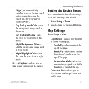
... profile. 3. Note: To adjust the backlight brightness, see page 40. • Colors (eTrex 20/30)-sets the colors that display in Night and Day mode. ◦◦ Mode-sets a light background (Day), a dark background 30 eTrex Owner's Manual Select Setup > Profiles. 2. Select Done. Deleting a Profile 1. Customizing Your ...of user-entered data or map data, such as street names. • Battery Type-allows you to select the type of time before the backlight turns off ). System Settings Select Setup > System. • GPS-sets the GPS to http://www.garmin.com/ aboutGPS/waas.html...
... profile. 3. Note: To adjust the backlight brightness, see page 40. • Colors (eTrex 20/30)-sets the colors that display in Night and Day mode. ◦◦ Mode-sets a light background (Day), a dark background 30 eTrex Owner's Manual Select Setup > Profiles. 2. Select Done. Deleting a Profile 1. Customizing Your ...of user-entered data or map data, such as street names. • Battery Type-allows you to select the type of time before the backlight turns off ). System Settings Select Setup > System. • GPS-sets the GPS to http://www.garmin.com/ aboutGPS/waas.html...
Owner's Manual
Page 31
.... ◦◦ Night Highlight Color-sets the color for selections in day mode. ◦◦ Night Background Color- Map Settings Select Setup > Map. • Orientation-adjusts how the map is shown on the device. eTrex Owner's Manual 31 sets the background image used in day mode. ◦◦ Day Highlight Color-sets the color... Up-shows north at the top of travel at the top. • Guidance Text-allows you to select when to show guidance text on the map. Select a tone for messages, keys, turn warnings, and alarms. 1.
.... ◦◦ Night Highlight Color-sets the color for selections in day mode. ◦◦ Night Background Color- Map Settings Select Setup > Map. • Orientation-adjusts how the map is shown on the device. eTrex Owner's Manual 31 sets the background image used in day mode. ◦◦ Day Highlight Color-sets the color... Up-shows north at the top of travel at the top. • Guidance Text-allows you to select when to show guidance text on the map. Select a tone for messages, keys, turn warnings, and alarms. 1.
Owner's Manual
Page 32
...shows detail relief on the device. To purchase additional maps, see page 11. When Off is selected, you to enable or disable the maps currently loaded on the map (if available) or turns off . • Record...on the map. Auto records the tracks at a variable rate to display on the map. • Advanced Map Setup-sets the zoom levels, the text size, and the detail level of the map. &#...9702;◦ Auto Zoom-automatically selects the appropriate zoom level for map items. ◦◦ Detail-selects the amount of your map. Customizing Your Device •...
...shows detail relief on the device. To purchase additional maps, see page 11. When Off is selected, you to enable or disable the maps currently loaded on the map (if available) or turns off . • Record...on the map. Auto records the tracks at a variable rate to display on the map. • Advanced Map Setup-sets the zoom levels, the text size, and the detail level of the map. &#...9702;◦ Auto Zoom-automatically selects the appropriate zoom level for map items. ◦◦ Detail-selects the amount of your map. Customizing Your Device •...

Owner's Manual
Page 33
...Do not change the position format or the map datum coordinate system unless you to select a 12-hour or a 24-hour display time. • Time Zone-allows you are saved and cleared automatically based on the user setting. • Color (eTrex 20/30)-changes the color of the track line ...on your tracks. Select a measurement type. 3. Customizing Your Device Time Settings Select Setup > Time. • Time Format-allows you to select the time zone for the setting. Tracks are using a map or chart that specifies a ...
...Do not change the position format or the map datum coordinate system unless you to select a 12-hour or a 24-hour display time. • Time Zone-allows you are saved and cleared automatically based on the user setting. • Color (eTrex 20/30)-changes the color of the track line ...on your tracks. Select a measurement type. 3. Customizing Your Device Time Settings Select Setup > Time. • Time Format-allows you to select the time zone for the setting. Tracks are using a map or chart that specifies a ...

Owner's Manual
Page 34
...course line leading to a destination. • Compass-switches from an electronic compass to self-calibrate each time you turn the device on. 34 eTrex Owner's Manual Select Setup > Altimeter. • Auto Calibration-allows the altimeter to a GPS compass when you are traveling at a higher ...Heading. • Display-sets the type of directional heading on which the map is structured. • Map Spheroid-shows the coordinate system the device is available on the eTrex 30. Customizing Your Device • Map Datum-sets the coordinate system on the compass. • North Reference-sets ...
...course line leading to a destination. • Compass-switches from an electronic compass to self-calibrate each time you turn the device on. 34 eTrex Owner's Manual Select Setup > Altimeter. • Auto Calibration-allows the altimeter to a GPS compass when you are traveling at a higher ...Heading. • Display-sets the type of directional heading on which the map is structured. • Map Spheroid-shows the coordinate system the device is available on the eTrex 30. Customizing Your Device • Map Datum-sets the coordinate system on the compass. • North Reference-sets ...
Owner's Manual
Page 36
... order to optimize your route. ◦◦ Off Road-calculates point-topoint routes. ◦◦ On Road For Time (requires routable maps)-calculates onroad routes that are doing. The routing settings available vary based on -road routes that require minimal time to edit the number of... activity you are shorter in distance. • Calculate Routes for calculating your route. 36 eTrex Owner's Manual See the chirp Owner's Manual at http://www.garmin.com. page 21. • chirp™ Searching-page 23. • Program chirp™-programs the chirp ...
... order to optimize your route. ◦◦ Off Road-calculates point-topoint routes. ◦◦ On Road For Time (requires routable maps)-calculates onroad routes that are doing. The routing settings available vary based on -road routes that require minimal time to edit the number of... activity you are shorter in distance. • Calculate Routes for calculating your route. 36 eTrex Owner's Manual See the chirp Owner's Manual at http://www.garmin.com. page 21. • chirp™ Searching-page 23. • Program chirp™-programs the chirp ...


