

Owner's Manual
Page 5
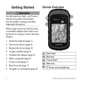
Acquire satellites (page 8). 4. Mark a waypoint (page 9). 6. Calibrate the compass (page 17). ➊ Zoom keys ➋ Back key ➌ Thumb Stick™ ➍ Menu key ➎ /Backlight key eTrex Owner's Manual 5 Record a track (page 14). 8. Create a route (page 12). 7. Getting Started Getting Started Device Overview ‹ warning See the Important Safety and Product Information ...
Acquire satellites (page 8). 4. Mark a waypoint (page 9). 6. Calibrate the compass (page 17). ➊ Zoom keys ➋ Back key ➌ Thumb Stick™ ➍ Menu key ➎ /Backlight key eTrex Owner's Manual 5 Record a track (page 14). 8. Create a route (page 12). 7. Getting Started Getting Started Device Overview ‹ warning See the Important Safety and Product Information ...

Owner's Manual
Page 17
Select Profile Change > Automotive. 2. Navigation Compass The eTrex 30 has a 3-axis, electronic compass. • Select a location on the eTrex 20 and eTrex 30. Use the map to navigate to your vehicle... navigate to the destination. 3. Navigating a Driving Route Driving route navigation is using the automotive profile, the compass displays GPS heading, not magnetic heading. Follow the turns in your destination. Before you can use the map... the bar at the top of the map. Calibrating the Compass Notice Calibrate the electronic compass outdoors. eTrex Owner's Manual 17
Select Profile Change > Automotive. 2. Navigation Compass The eTrex 30 has a 3-axis, electronic compass. • Select a location on the eTrex 20 and eTrex 30. Use the map to navigate to your vehicle... navigate to the destination. 3. Navigating a Driving Route Driving route navigation is using the automotive profile, the compass displays GPS heading, not magnetic heading. Follow the turns in your destination. Before you can use the map... the bar at the top of the map. Calibrating the Compass Notice Calibrate the electronic compass outdoors. eTrex Owner's Manual 17

Owner's Manual
Page 18
... You should calibrate the compass after moving in your path. ➍ ➋ ➌ ➊ The course pointer ➊ indicates your relationship to a course line ➋ leading to the destination. The course line to the destination. Follow the on water or where there are moving. 1. Begin navigation to the distance 18 eTrex Owner's Manual...
... You should calibrate the compass after moving in your path. ➍ ➋ ➌ ➊ The course pointer ➊ indicates your relationship to a course line ➋ leading to the destination. The course line to the destination. Follow the on water or where there are moving. 1. Begin navigation to the distance 18 eTrex Owner's Manual...

Owner's Manual
Page 34
Heading Settings This function is available on the eTrex 30. Altimeter Settings This function is available on the eTrex 30. Customizing Your Device • Map Datum-sets the coordinate system on . 34 eTrex Owner's Manual The default coordinate system is using. sets the direction to your ...-shows the coordinate system the device is WGS 84. Select Setup > Altimeter. • Auto Calibration-allows the altimeter to self-calibrate each time you are traveling at a higher rate of speed for a set period of time (Auto), or turns the compass off. • Calibrate Compass-page 17.
Heading Settings This function is available on the eTrex 30. Altimeter Settings This function is available on the eTrex 30. Customizing Your Device • Map Datum-sets the coordinate system on . 34 eTrex Owner's Manual The default coordinate system is using. sets the direction to your ...-shows the coordinate system the device is WGS 84. Select Setup > Altimeter. • Auto Calibration-allows the altimeter to self-calibrate each time you are traveling at a higher rate of speed for a set period of time (Auto), or turns the compass off. • Calibrate Compass-page 17.

Owner's Manual
Page 54
... map setup 32 alarms clock 26 marine 38 proximity 24 tones for 31 almanac hunting and fishing 25 sunrise and sunset 25 altimeter calibrating 20 plot type 35 settings 34 ANT+ accessories 46 area calculation 25 automotive mode 31 auto mounts 17 auto zoom 32 B backlight timeout...warnings 7 BirdsEye satellite imagery 11 BlueChart g2 maps 11 54 C calculator 25 calendar 25 calibrating altimeter 20 compass 18 caring for the device 42 long-term storage 42 chirp 23 City Navigator maps 17 compass 17 calibrating 18 navigating 18 restore 39 setup options 34 connecting to another device 24 USB cable 44...
... map setup 32 alarms clock 26 marine 38 proximity 24 tones for 31 almanac hunting and fishing 25 sunrise and sunset 25 altimeter calibrating 20 plot type 35 settings 34 ANT+ accessories 46 area calculation 25 automotive mode 31 auto mounts 17 auto zoom 32 B backlight timeout...warnings 7 BirdsEye satellite imagery 11 BlueChart g2 maps 11 54 C calculator 25 calendar 25 calibrating altimeter 20 compass 18 caring for the device 42 long-term storage 42 chirp 23 City Navigator maps 17 compass 17 calibrating 18 navigating 18 restore 39 setup options 34 connecting to another device 24 USB cable 44...
Quick Start Manual
Page 2
...Information guide in the product box for product warnings and other important information. Record a track (page 7). 9. Acquire satellites (page 4). 5. Calibrate the compass (page 5). 6. Mark a waypoint (page 6). 7. Register the device (page 4). 4. When using your device the first time, you... ➎ ➊ Zoom keys ➋ Back key ➌ Thumb Stick™ ➍ Menu key ➎ Power and backlight key 2 eTrex 20/30 Quick Start Manual Turn on the device (page 4). 3. Navigate to know the basic features. 1. Install the batteries (page 3). 2. Create a route (page...
...Information guide in the product box for product warnings and other important information. Record a track (page 7). 9. Acquire satellites (page 4). 5. Calibrate the compass (page 5). 6. Mark a waypoint (page 6). 7. Register the device (page 4). 4. When using your device the first time, you... ➎ ➊ Zoom keys ➋ Back key ➌ Thumb Stick™ ➍ Menu key ➎ Power and backlight key 2 eTrex 20/30 Quick Start Manual Turn on the device (page 4). 3. Navigate to know the basic features. 1. Install the batteries (page 3). 2. Create a route (page...

Quick Start Manual
Page 5
...near objects that optimize your settings and views can significantly reduce battery life. 1. Select Compass. 2. Follow the on , press . 2. Calibrating the Compass Notice Calibrate the electronic compass outdoors. For example, your device based on how you are using the device for geocaching.... 2. Waypoints Waypoints are locations you record and store in the device. The eTrex 30 has a 3-axis, electronic compass. can be different when you are using it. Select Calibrate Compass > Start. 4. eTrex 20/30 Quick Start Manual 5 Select menu. 3. Select a profile. While the ...
...near objects that optimize your settings and views can significantly reduce battery life. 1. Select Compass. 2. Follow the on , press . 2. Calibrating the Compass Notice Calibrate the electronic compass outdoors. For example, your device based on how you are using the device for geocaching.... 2. Waypoints Waypoints are locations you record and store in the device. The eTrex 30 has a 3-axis, electronic compass. can be different when you are using it. Select Calibrate Compass > Start. 4. eTrex 20/30 Quick Start Manual 5 Select menu. 3. Select a profile. While the ...


