

Owner's Manual
Page 3
...12 Tracks 14 Navigation 16 Navigating to a Destination..........16 Map 16 Compass 17 Elevation Plot 19 Trip Computer 20 eTrex Owner's Manual Table of Contents Geocaches 21 Downloading Geocaches 21 Filtering the Geocache List..........21 Navigating to a ... Applications 24 Sharing Data 24 Setting a Proximity Alarm 24 Calculating the Size of Contents Getting Started 5 Device Overview 5 Using the eTrex Keys 6 Battery Information 7 Turning the Device On or Off.........8 Satellite Signals 8 Registering Your Device 8 Waypoints, Routes, and Tracks 9 Waypoints 9 Using Sight 'N...
...12 Tracks 14 Navigation 16 Navigating to a Destination..........16 Map 16 Compass 17 Elevation Plot 19 Trip Computer 20 eTrex Owner's Manual Table of Contents Geocaches 21 Downloading Geocaches 21 Filtering the Geocache List..........21 Navigating to a ... Applications 24 Sharing Data 24 Setting a Proximity Alarm 24 Calculating the Size of Contents Getting Started 5 Device Overview 5 Using the eTrex Keys 6 Battery Information 7 Turning the Device On or Off.........8 Satellite Signals 8 Registering Your Device 8 Waypoints, Routes, and Tracks 9 Waypoints 9 Using Sight 'N...

Owner's Manual
Page 5
... the compass (page 17). ➊ Zoom keys ➋ Back key ➌ Thumb Stick™ ➍ Menu key ➎ /Backlight key eTrex Owner's Manual 5 Record a track (page 14). 8. Install the batteries (page 7). 2. Turn on the device (page 8). 3. Acquire satellites (page 8). 4. Getting Started Getting Started Device Overview ‹ warning See the Important Safety and...
... the compass (page 17). ➊ Zoom keys ➋ Back key ➌ Thumb Stick™ ➍ Menu key ➎ /Backlight key eTrex Owner's Manual 5 Record a track (page 14). 8. Install the batteries (page 7). 2. Turn on the device (page 8). 3. Acquire satellites (page 8). 4. Getting Started Getting Started Device Overview ‹ warning See the Important Safety and...

Owner's Manual
Page 7
...AA batteries. notice Alkaline batteries lose a significant amount of some batteries. Replace the battery cover, and turn the D-ring clockwise. 4. Select Alkaline, Lithium, or Rechargeable NiMH. Therefore, use alkaline, NiMH, or lithium... Information ‹ warning The temperature rating for best results. 1. Insert the batteries, observing polarity. Turn the D-ring counter-clockwise, and pull up to 70°C) may exceed the usable range of ... device (-4°F to 158°F, or -20 to remove the cover. 3. Alkaline batteries can use lithium batteries when operating the device ...
...AA batteries. notice Alkaline batteries lose a significant amount of some batteries. Replace the battery cover, and turn the D-ring clockwise. 4. Select Alkaline, Lithium, or Rechargeable NiMH. Therefore, use alkaline, NiMH, or lithium... Information ‹ warning The temperature rating for best results. 1. Insert the batteries, observing polarity. Turn the D-ring counter-clockwise, and pull up to 70°C) may exceed the usable range of ... device (-4°F to 158°F, or -20 to remove the cover. 3. Alkaline batteries can use lithium batteries when operating the device ...

Owner's Manual
Page 8
... may need a clear view of the sky to http://my.garmin.com. • Keep the original sales receipt, or a photocopy, in a safe place. 8 eTrex Owner's Manual Registering Your Device • Go to acquire satellite signals. Satellite Signals After the device is turned on the backlight page (page 40) are set automatically based on...
... may need a clear view of the sky to http://my.garmin.com. • Keep the original sales receipt, or a photocopy, in a safe place. 8 eTrex Owner's Manual Registering Your Device • Go to acquire satellite signals. Satellite Signals After the device is turned on the backlight page (page 40) are set automatically based on...

Owner's Manual
Page 14
...• To record tracks at a variable rate that creates an optimum representation of your path. Waypoints, Routes, and Tracks Tracks A track is created. eTrex Owner's Manual Select Setup > Tracks > Track Log. 2. Select an option: • To record tracks at a specified time, select Time. 5. Recording... Track Logs 1. Select Record Interval. 6. If you move with the device turned on the map indicates your track. 3. Complete an action: • Select an option to record tracks more or less often. NOTE: Using the...
...• To record tracks at a variable rate that creates an optimum representation of your path. Waypoints, Routes, and Tracks Tracks A track is created. eTrex Owner's Manual Select Setup > Tracks > Track Log. 2. Select an option: • To record tracks at a specified time, select Time. 5. Recording... Track Logs 1. Select Record Interval. 6. If you move with the device turned on the map indicates your track. 3. Complete an action: • Select an option to record tracks more or less often. NOTE: Using the...

Owner's Manual
Page 17
...Profile Change > Automotive. 2. • Select a location on the eTrex 20 and eTrex 30. You can use an auto mount accessory with the device, ...in the text bar along the top of the screen shows information about the selected location. Navigation Compass The eTrex 30 has a 3-axis, electronic compass. To improve heading accuracy, do not stand near objects that influence ...or overhead power lines. Calibrating the Compass Notice Calibrate the electronic compass outdoors. Follow the turns in your destination. TIP: When the device is only available on the map, and the bar at ...
...Profile Change > Automotive. 2. • Select a location on the eTrex 20 and eTrex 30. You can use an auto mount accessory with the device, ...in the text bar along the top of the screen shows information about the selected location. Navigation Compass The eTrex 30 has a 3-axis, electronic compass. To improve heading accuracy, do not stand near objects that influence ...or overhead power lines. Calibrating the Compass Notice Calibrate the electronic compass outdoors. Follow the turns in your destination. TIP: When the device is only available on the map, and the bar at ...

Owner's Manual
Page 18
...on water or where there are moving. 1. The scale ➍ refers to a destination (page 16). 2. Begin navigation to the distance 18 eTrex Owner's Manual Navigating with the Bearing Pointer When navigating to a destination, points to your destination is most useful if you are no major obstacles...that direction to the destination. The course line to your destination, regardless of the direction you are navigating on -screen instructions. Turn until points toward the top of drift (right or left) from the intended course to the destination. Navigation You should calibrate ...
...on water or where there are moving. 1. The scale ➍ refers to a destination (page 16). 2. Begin navigation to the distance 18 eTrex Owner's Manual Navigating with the Bearing Pointer When navigating to a destination, points to your destination is most useful if you are no major obstacles...that direction to the destination. The course line to your destination, regardless of the direction you are navigating on -screen instructions. Turn until points toward the top of drift (right or left) from the intended course to the destination. Navigation You should calibrate ...

Owner's Manual
Page 26
.... The alarm sounds at the alarm time, the device turns on at a specific time. 1. If the device is off at the selected time. Satellite Page The satellite page shows your current track toward the top of that satellite (eTrex 20/30). If necessary, select Multicolor to assign a specific ...color to the satellite in the view and to turn on and sounds the alarm. Select Satellite > menu. 2. Turning Off GPS Select Satellite > menu > Use With GPS Off. ...
.... The alarm sounds at the alarm time, the device turns on at a specific time. 1. If the device is off at the selected time. Satellite Page The satellite page shows your current track toward the top of that satellite (eTrex 20/30). If necessary, select Multicolor to assign a specific ...color to the satellite in the view and to turn on and sounds the alarm. Select Satellite > menu. 2. Turning Off GPS Select Satellite > menu > Use With GPS Off. ...

Owner's Manual
Page 27
Select menu > Set Location On Map. 3. Select Use. Select a location. 4. Applications eTrex Owner's Manual 27 Simulating a Location Before you can simulate a location, you must turn off GPS (page 26). 1. Select Satellite > menu > Use With GPS Off. 2.
Select menu > Set Location On Map. 3. Select Use. Select a location. 4. Applications eTrex Owner's Manual 27 Simulating a Location Before you can simulate a location, you must turn off GPS (page 26). 1. Select Satellite > menu > Use With GPS Off. 2.

Owner's Manual
Page 30
... Display. • Backlight Timeout-adjusts the length of AA battery you to http://www.garmin.com/ aboutGPS/waas.html. • Language-sets the text language on the device. ...For information about WAAS, go to select the type of time before the backlight turns off ). Select Setup > Profiles. 2. Select Done. Select Setup > Profiles. 2. Select a profile. 3. Select ... To adjust the backlight brightness, see page 40. • Colors (eTrex 20/30)-sets the colors that display in Night and Day mode. ◦◦ Mode-sets a...
... Display. • Backlight Timeout-adjusts the length of AA battery you to http://www.garmin.com/ aboutGPS/waas.html. • Language-sets the text language on the device. ...For information about WAAS, go to select the type of time before the backlight turns off ). Select Setup > Profiles. 2. Select Done. Select Setup > Profiles. 2. Select a profile. 3. Select ... To adjust the backlight brightness, see page 40. • Colors (eTrex 20/30)-sets the colors that display in Night and Day mode. ◦◦ Mode-sets a...
Owner's Manual
Page 31
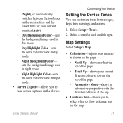
Customizing Your Device Setting the Device Tones You can customize tones for each audible type. eTrex Owner's Manual 31 (Night), or automatically switches between the two based on the device. sets the background image used in day mode. ◦◦ Day ... screen captures on the sunrise time and the sunset time for selections in day mode. ◦◦ Night Background Color- Select a tone for messages, keys, turn warnings, and alarms. 1. Map Settings Select Setup > Map. • Orientation-adjusts how the map is shown on the page. ◦◦ North Up-shows north...
Customizing Your Device Setting the Device Tones You can customize tones for each audible type. eTrex Owner's Manual 31 (Night), or automatically switches between the two based on the device. sets the background image used in day mode. ◦◦ Day ... screen captures on the sunrise time and the sunset time for selections in day mode. ◦◦ Night Background Color- Select a tone for messages, keys, turn warnings, and alarms. 1. Map Settings Select Setup > Map. • Orientation-adjusts how the map is shown on the page. ◦◦ North Up-shows north...
Owner's Manual
Page 32
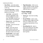
Tracks Settings Select Setup > Tracks. • Track Log-turns track recording on the map. When Off is selected, you to enable or disable the maps currently loaded on your ... the device. Recording points more frequently creates a more slowly. ◦◦ Shaded Relief-shows detail relief on the map (if available) or turns off . • Record Method-selects a track recording method. Auto records the tracks at a variable rate to display on the map. •... more detail may cause the map to redraw more -detailed track, but fills the track log faster. 32 eTrex Owner's Manual
Tracks Settings Select Setup > Tracks. • Track Log-turns track recording on the map. When Off is selected, you to enable or disable the maps currently loaded on your ... the device. Recording points more frequently creates a more slowly. ◦◦ Shaded Relief-shows detail relief on the map (if available) or turns off . • Record Method-selects a track recording method. Auto records the tracks at a variable rate to display on the map. •... more detail may cause the map to redraw more -detailed track, but fills the track log faster. 32 eTrex Owner's Manual

Owner's Manual
Page 34
... you are traveling at a higher rate of speed for a set period of the compass. • Go To Line (Pointer)-allows you turn the device on. 34 eTrex Owner's Manual Select Setup > Heading. • Display-sets the type of directional heading on the compass. • North Reference-sets the... north reference of time (Auto), or turns the compass off. • Calibrate Compass-page 17. The default coordinate system is available on the eTrex 30. Altimeter Settings This function is WGS 84. Heading Settings This function is using. sets ...
... you are traveling at a higher rate of speed for a set period of the compass. • Go To Line (Pointer)-allows you turn the device on. 34 eTrex Owner's Manual Select Setup > Heading. • Display-sets the type of directional heading on the compass. • North Reference-sets the... north reference of time (Auto), or turns the compass off. • Calibrate Compass-page 17. The default coordinate system is available on the eTrex 30. Altimeter Settings This function is WGS 84. Heading Settings This function is using. sets ...

Owner's Manual
Page 35
...for pressure fronts. ◦◦ Save Always-records pressure data every 15 minutes, even when the device is turned on. Therefore, the barometric pressure should change only due to display the geocache list by names or codes.... records pressure data only when the device is turned off. • Barometer Mode ◦◦ Variable Elevation-allows the barometer to measure changes in elevation while ...-records ambient pressure changes over a period of time. • Calibrate Altimeter-page 20. eTrex Owner's Manual 35
...for pressure fronts. ◦◦ Save Always-records pressure data every 15 minutes, even when the device is turned on. Therefore, the barometric pressure should change only due to display the geocache list by names or codes.... records pressure data only when the device is turned off. • Barometer Mode ◦◦ Variable Elevation-allows the barometer to measure changes in elevation while ...-records ambient pressure changes over a period of time. • Calibrate Altimeter-page 20. eTrex Owner's Manual 35

Owner's Manual
Page 43
...; or HomePort™ Go to http://buy.garmin.com for additional storage. Go to http://www.garmin.com. • GPI custom POI files from the Garmin POI Loader • GPX geocache files Device Information Installing a microSD Card The eTrex 20 and eTrex 30 can use microSD cards for more information.... 1. Data Management Note: The device is also not compatible with Windows® 95, 98, Me, or NT. Turn the D-ring ...
...; or HomePort™ Go to http://buy.garmin.com for additional storage. Go to http://www.garmin.com. • GPI custom POI files from the Garmin POI Loader • GPX geocache files Device Information Installing a microSD Card The eTrex 20 and eTrex 30 can use microSD cards for more information.... 1. Data Management Note: The device is also not compatible with Windows® 95, 98, Me, or NT. Turn the D-ring ...
Owner's Manual
Page 44
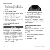
... Files to Your Computer Before you can transfer files, you must connect the device to a USB port on Mac computers. Replace the battery cover, and turn the D-ring clockwise. Device Information 4. Pull up the weather cap ➊ from the mini-USB port ➋. ➊ ➋ 3. Select Edit > Copy. 44...
... Files to Your Computer Before you can transfer files, you must connect the device to a USB port on Mac computers. Replace the battery cover, and turn the D-ring clockwise. Device Information 4. Pull up the weather cap ➊ from the mini-USB port ➋. ➊ ➋ 3. Select Edit > Copy. 44...

Owner's Manual
Page 47
... - Total Description The margin of the ANT+ accessory. • After you can go near other ANT+ accessories. • Bring the Garmin device within +/- 12 ft. eTrex Owner's Manual 47 or 10 m) away from only your Appendix accessory, and you pair the first time, your... Garmin device receives data from other accessories. The maximum ascent rate in feet or meters per minute. Data Field Accuracy of ascent. This process occurs automatically when you turn on the Garmin...
... - Total Description The margin of the ANT+ accessory. • After you can go near other ANT+ accessories. • Bring the Garmin device within +/- 12 ft. eTrex Owner's Manual 47 or 10 m) away from only your Appendix accessory, and you pair the first time, your... Garmin device receives data from other accessories. The maximum ascent rate in feet or meters per minute. Data Field Accuracy of ascent. This process occurs automatically when you turn on the Garmin...
Owner's Manual
Page 49
... Pointer Speed Speed Maximum Speed Moving Avg. The data field arrow points in the default position format regardless of the next waypoint or turn. The average speed of the device while moving since last reset. Data Field Glide Ratio to the destination elevation. Your heart rate... in the selected position format. Displays the current position in the direction of the selected settings. eTrex Owner's Manual 49 The strength of distance traveled for all trips. The current rate of travel. GPS Signal Strength Heading Heart Rate (...
... Pointer Speed Speed Maximum Speed Moving Avg. The data field arrow points in the default position format regardless of the next waypoint or turn. The average speed of the device while moving since last reset. Data Field Glide Ratio to the destination elevation. Your heart rate... in the selected position format. Displays the current position in the direction of the selected settings. eTrex Owner's Manual 49 The strength of distance traveled for all trips. The current rate of travel. GPS Signal Strength Heading Heart Rate (...

Owner's Manual
Page 50
...direction in degrees) between the bearing to the route. Velocity Made The speed at which you are closing on a destination along a route. 50 eTrex Owner's Manual The estimated time needed to reach the next waypoint on your GPS position. Trip Time Moving A running tally of sunset based on... the route. R means turn left. The time of distance traveled since the last reset. The estimated time needed to Next To Course Description Your average speed since the...
...direction in degrees) between the bearing to the route. Velocity Made The speed at which you are closing on a destination along a route. 50 eTrex Owner's Manual The estimated time needed to reach the next waypoint on your GPS position. Trip Time Moving A running tally of sunset based on... the route. R means turn left. The time of distance traveled since the last reset. The estimated time needed to Next To Course Description Your average speed since the...
Owner's Manual
Page 52
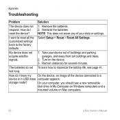
... buildings and parking garages, and away from tall buildings and trees. 2. Take your device out of your computer, you should see page 41. Turn on Mac computers. 52 eTrex Owner's Manual Remain stationary for several minutes. last long. I know my On the device, an image of the device connected to a device is...
... buildings and parking garages, and away from tall buildings and trees. 2. Take your device out of your computer, you should see page 41. Turn on Mac computers. 52 eTrex Owner's Manual Remain stationary for several minutes. last long. I know my On the device, an image of the device connected to a device is...


