

Owner's Manual
Page 3
.............16 Map 16 Compass 17 Elevation Plot 19 Trip Computer 20 eTrex Owner's Manual Table of Contents Geocaches 21 Downloading Geocaches 21 Filtering the Geocache List..........21 Navigating to a Geocache............22 Logging the Attempt 22 chirp 23 Applications 24 Sharing Data 24 Setting a Proximity Alarm 24 Calculating the Size of Contents Getting Started 5 Device Overview 5 Using the eTrex Keys 6 Battery Information 7 Turning the Device On or Off.........8 Satellite Signals 8 Registering Your Device 8 Waypoints, Routes, and Tracks 9 Waypoints 9 Using Sight...
.............16 Map 16 Compass 17 Elevation Plot 19 Trip Computer 20 eTrex Owner's Manual Table of Contents Geocaches 21 Downloading Geocaches 21 Filtering the Geocache List..........21 Navigating to a Geocache............22 Logging the Attempt 22 chirp 23 Applications 24 Sharing Data 24 Setting a Proximity Alarm 24 Calculating the Size of Contents Getting Started 5 Device Overview 5 Using the eTrex Keys 6 Battery Information 7 Turning the Device On or Off.........8 Satellite Signals 8 Registering Your Device 8 Waypoints, Routes, and Tracks 9 Waypoints 9 Using Sight...

Owner's Manual
Page 4
... Tracks Settings 32 Changing the Units of Measure...33 Time Settings 33 Position Format Settings 33 Heading Settings 34 Altimeter Settings 34 Geocaching Settings 35 Routing Settings 36 Marine Map Settings 37 Fitness 38 Resetting Data 38 Changing the Page Sequence.....39 Device Information 40 Adjusting the Screen 40 Updating the Software 40 Viewing Device Information..........40 Specifications 41 About the Batteries 41 Caring for the Device 42 Data Management 43 Appendix 46 Optional Accessories 46 Data Field Options 47 Troubleshooting 52 Index 54 4 eTrex Owner's Manual
... Tracks Settings 32 Changing the Units of Measure...33 Time Settings 33 Position Format Settings 33 Heading Settings 34 Altimeter Settings 34 Geocaching Settings 35 Routing Settings 36 Marine Map Settings 37 Fitness 38 Resetting Data 38 Changing the Page Sequence.....39 Device Information 40 Adjusting the Screen 40 Updating the Software 40 Viewing Device Information..........40 Specifications 41 About the Batteries 41 Caring for the Device 42 Data Management 43 Appendix 46 Optional Accessories 46 Data Field Options 47 Troubleshooting 52 Index 54 4 eTrex Owner's Manual

Owner's Manual
Page 5
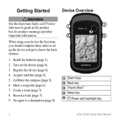
... and Product Information guide in the product ➊ box for product warnings and other important information. ➍ ➋ ➌ ➎ When using your device the first time, you should complete these tasks to set up the device and get to a destination (page 16). 9. Calibrate the compass (page 17). ➊ Zoom keys ➋ Back key ➌ Thumb Stick™ ➍ Menu key ➎ /Backlight key eTrex Owner's Manual 5 Create a route (page 12...
... and Product Information guide in the product ➊ box for product warnings and other important information. ➍ ➋ ➌ ➎ When using your device the first time, you should complete these tasks to set up the device and get to a destination (page 16). 9. Calibrate the compass (page 17). ➊ Zoom keys ➋ Back key ➌ Thumb Stick™ ➍ Menu key ➎ /Backlight key eTrex Owner's Manual 5 Create a route (page 12...

Owner's Manual
Page 13
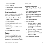
...point you are editing. • To remove the point from the route, select Remove. 6. Deleting a Route 1. Reversing a Route 1. Select Delete Route. Select Edit Route. 4. Select a route. 3. Select View Map. While navigating a route, select Active Route. 2. Select a point in the route to save the route. Select a route. 3. eTrex Owner's Manual 13 Select a point. 5. Select an option: • To view the point on the map, select Review. • To change the order of the point on the route, select Move Down or Move Up. • To add an additional point on the Map 1. Select Route...
...point you are editing. • To remove the point from the route, select Remove. 6. Deleting a Route 1. Reversing a Route 1. Select Delete Route. Select Edit Route. 4. Select a route. 3. Select View Map. While navigating a route, select Active Route. 2. Select a point in the route to save the route. Select a route. 3. eTrex Owner's Manual 13 Select a point. 5. Select an option: • To view the point on the map, select Review. • To change the order of the point on the route, select Move Down or Move Up. • To add an additional point on the Map 1. Select Route...

Owner's Manual
Page 15
... Routes, and Tracks Viewing the Elevation Plot of the track are marked by flags. 4. Select a track. 3. Select Track Manager. 2. Select a saved track. 3. Select what you want to save : • Select Save Track. • Select Save Portion, and select a portion. Select Elevation Plot. Select Track Manager. 2. Saving the Current Track The track being recorded is listed. Select Track Manager > Current Track. 2. Select a track. 3. Select menu > Review Track. Clearing the Current Track Select Setup > Reset > Clear Current Track > Yes. Deleting a Track 1. Select a track...
... Routes, and Tracks Viewing the Elevation Plot of the track are marked by flags. 4. Select a track. 3. Select Track Manager. 2. Select a saved track. 3. Select what you want to save : • Select Save Track. • Select Save Portion, and select a portion. Select Elevation Plot. Select Track Manager. 2. Saving the Current Track The track being recorded is listed. Select Track Manager > Current Track. 2. Select a track. 3. Select menu > Review Track. Clearing the Current Track Select Setup > Reset > Clear Current Track > Yes. Deleting a Track 1. Select a track...

Owner's Manual
Page 17
... the eTrex 20 and eTrex 30. Follow the turns in your destination. eTrex Owner's Manual 17 Before you must purchase and load City Navigator maps. You can use an auto mount accessory with the device, you can use a bearing pointer or a course pointer to navigate to your vehicle. 1. Calibrating the Compass Notice Calibrate the electronic compass outdoors. If you must also purchase and install the mount in the text bar along the top of the screen shows information...
... the eTrex 20 and eTrex 30. Follow the turns in your destination. eTrex Owner's Manual 17 Before you must purchase and load City Navigator maps. You can use an auto mount accessory with the device, you can use a bearing pointer or a course pointer to navigate to your vehicle. 1. Calibrating the Compass Notice Calibrate the electronic compass outdoors. If you must also purchase and install the mount in the text bar along the top of the screen shows information...

Owner's Manual
Page 19
... time or distance. 1. Navigation Changing the Plot Type You can navigate with the course pointer, you must change the elevation plot to Course (CDI) (page 34). 1. eTrex Owner's Manual 19 Select an option. Details about a Point on the Plot Select an individual point on the plot. between dots on the eTrex 30. To customize the elevation plot, see page 34. Select Elevation Plot. Resetting the Elevation Plot Select Elevation Plot > menu > Reset > Clear Current Track > Yes. Use the course pointer to navigate to a destination (page 16). 2. Select Compass. 3. Select...
... time or distance. 1. Navigation Changing the Plot Type You can navigate with the course pointer, you must change the elevation plot to Course (CDI) (page 34). 1. eTrex Owner's Manual 19 Select an option. Details about a Point on the Plot Select an individual point on the plot. between dots on the eTrex 30. To customize the elevation plot, see page 34. Select Elevation Plot. Resetting the Elevation Plot Select Elevation Plot > menu > Reset > Clear Current Track > Yes. Use the course pointer to navigate to a destination (page 16). 2. Select Compass. 3. Select...

Owner's Manual
Page 26
... bar of the screen. 3. The alarm sounds at a specific time. 1. If necessary, select Track Up to change the view of the satellites to set the device to turn on and sounds the alarm. Changing the Satellite View 1. Turning Off GPS Select Satellite > menu > Use With GPS Off. 26 eTrex Owner's Manual Select Alarm Clock. 2. Opening the Stopwatch Select Stopwatch. Select the clock numbers to be oriented with your current location, GPS accuracy, satellite locations, and signal strength. If the device is off at the alarm time, the device turns on at the selected time.
... bar of the screen. 3. The alarm sounds at a specific time. 1. If necessary, select Track Up to change the view of the satellites to set the device to turn on and sounds the alarm. Changing the Satellite View 1. Turning Off GPS Select Satellite > menu > Use With GPS Off. 26 eTrex Owner's Manual Select Alarm Clock. 2. Opening the Stopwatch Select Stopwatch. Select the clock numbers to be oriented with your current location, GPS accuracy, satellite locations, and signal strength. If the device is off at the alarm time, the device turns on at the selected time.
Owner's Manual
Page 28
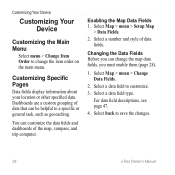
..., compass, and trip computer. Select Map > menu > Setup Map > Data Fields. 2. Customizing Specific Pages Data fields display information about your location or other specified data. Select Map > menu > Change Data Fields. 2. Select a data field to save the changes. 28 eTrex Owner's Manual Dashboards are a custom grouping of data fields. Enabling the Map Data Fields 1. Select a number and style of data that can be helpful to a specific or general task, such as geocaching. For data field descriptions, see page 47. 4. Select back to customize. 3. Select a data field type...
..., compass, and trip computer. Select Map > menu > Setup Map > Data Fields. 2. Customizing Specific Pages Data fields display information about your location or other specified data. Select Map > menu > Change Data Fields. 2. Select a data field to save the changes. 28 eTrex Owner's Manual Dashboards are a custom grouping of data fields. Enabling the Map Data Fields 1. Select a number and style of data that can be helpful to a specific or general task, such as geocaching. For data field descriptions, see page 47. 4. Select back to customize. 3. Select a data field type...

Owner's Manual
Page 30
... Overlay Service), or Demo Mode (GPS off . note: Changing the text language does not change the language of user-entered data or map data, such as street names. • Battery Type-allows you to select the type of time before the backlight turns off ). Select a profile. 3. Display Settings Select Setup > Display. • Backlight Timeout-adjusts the length of AA battery you are using. Select Done. Select Delete > Yes. Select Setup > Profiles. 2. Customizing Your Device Editing a Profile Name 1. Select a profile. 3. Select Edit Name. 4. Select Setup > Profiles. 2.
... Overlay Service), or Demo Mode (GPS off . note: Changing the text language does not change the language of user-entered data or map data, such as street names. • Battery Type-allows you to select the type of time before the backlight turns off ). Select a profile. 3. Display Settings Select Setup > Display. • Backlight Timeout-adjusts the length of AA battery you are using. Select Done. Select Delete > Yes. Select Setup > Profiles. 2. Customizing Your Device Editing a Profile Name 1. Select a profile. 3. Select Edit Name. 4. Select Setup > Profiles. 2.

Owner's Manual
Page 33
...Position Format Settings Note: Do not change the position format or the map datum coordinate system unless you to select the time zone for the setting. Select a unit of measure for distance and speed, elevation, and pressure. 1. Select Setup > Position Format. • Position Format-sets the position format in which a given location reading appears. Select Setup > Units. 2. eTrex Owner's Manual 33 You can customize units of measure for the device. • Auto Archive-selects an automatic archive method to organize your GPS position. Select a measurement type. 3. Tracks are using...
...Position Format Settings Note: Do not change the position format or the map datum coordinate system unless you to select the time zone for the setting. Select a unit of measure for distance and speed, elevation, and pressure. 1. Select Setup > Position Format. • Position Format-sets the position format in which a given location reading appears. Select Setup > Units. 2. eTrex Owner's Manual 33 You can customize units of measure for the device. • Auto Archive-selects an automatic archive method to organize your GPS position. Select a measurement type. 3. Tracks are using...

Owner's Manual
Page 34
...; Map Datum-sets the coordinate system on which the map is structured. • Map Spheroid-shows the coordinate system the device is available on the eTrex 30. Select Setup > Heading. • Display-sets the type of directional heading on the compass. • North Reference-sets the north reference of time (Auto), or turns the compass off. • Calibrate Compass-page 17. Altimeter Settings This function is using. Select Setup > Altimeter. • Auto Calibration-allows the altimeter to self-calibrate each time you to a GPS compass when you are traveling at a higher rate...
...; Map Datum-sets the coordinate system on which the map is structured. • Map Spheroid-shows the coordinate system the device is available on the eTrex 30. Select Setup > Heading. • Display-sets the type of directional heading on the compass. • North Reference-sets the north reference of time (Auto), or turns the compass off. • Calibrate Compass-page 17. Altimeter Settings This function is using. Select Setup > Altimeter. • Auto Calibration-allows the altimeter to self-calibrate each time you to a GPS compass when you are traveling at a higher rate...

Owner's Manual
Page 43
...; GPI custom POI files from the Garmin POI Loader • GPX geocache files Device Information Installing a microSD Card The eTrex 20 and eTrex 30 can use microSD cards for more information. 1. Slide the card holder ➊ toward the bottom of the device and lift up to remove the cover. 2. Remove the batteries or battery. 3. File Types The device supports these file types. • Files from BaseCamp™ or HomePort™ Go to http://buy.garmin.com for additional storage. It...
...; GPI custom POI files from the Garmin POI Loader • GPX geocache files Device Information Installing a microSD Card The eTrex 20 and eTrex 30 can use microSD cards for more information. 1. Slide the card holder ➊ toward the bottom of the device and lift up to remove the cover. 2. Remove the batteries or battery. 3. File Types The device supports these file types. • Files from BaseCamp™ or HomePort™ Go to http://buy.garmin.com for additional storage. It...

Owner's Manual
Page 54
... 41 information 7, 41 installing 7 life 41 long term storage 42 maximizing life 41 selecting the type 7 storage 7 warnings 7 BirdsEye satellite imagery 11 BlueChart g2 maps 11 54 C calculator 25 calendar 25 calibrating altimeter 20 compass 18 caring for the device 42 long-term storage 42 chirp 23 City Navigator maps 17 compass 17 calibrating 18 navigating 18 restore 39 setup options 34 connecting to another device 24 USB cable 44 wireless accessories 46 course pointer 19 creating routes 12 waypoints 9 customizing data fields 28 eTrex Owner's Manual
... 41 information 7, 41 installing 7 life 41 long term storage 42 maximizing life 41 selecting the type 7 storage 7 warnings 7 BirdsEye satellite imagery 11 BlueChart g2 maps 11 54 C calculator 25 calendar 25 calibrating altimeter 20 compass 18 caring for the device 42 long-term storage 42 chirp 23 City Navigator maps 17 compass 17 calibrating 18 navigating 18 restore 39 setup options 34 connecting to another device 24 USB cable 44 wireless accessories 46 course pointer 19 creating routes 12 waypoints 9 customizing data fields 28 eTrex Owner's Manual

Owner's Manual
Page 55
... routes 37 E editing profiles 30 routes 12 waypoints 9 eTrex Owner's Manual elevation plot 19, 20 barometric altimeter 20 of a track 15 F file types 43 finding addresses 12 near your location 11 fishing times 25 fitness options 46 G geocaches 21, 35 downloading 21 filter list 21 logging attempt 22 navigating to 22 settings 35 GPS signals 8, 26, 30, 47, 49, 52 turning off 26 H heading settings 34 HomePort 43 Index hunting times 25 K keys 5, 6 L language 30 locking ring 6 M main menu customizing 28 map...
... routes 37 E editing profiles 30 routes 12 waypoints 9 eTrex Owner's Manual elevation plot 19, 20 barometric altimeter 20 of a track 15 F file types 43 finding addresses 12 near your location 11 fishing times 25 fitness options 46 G geocaches 21, 35 downloading 21 filter list 21 logging attempt 22 navigating to 22 settings 35 GPS signals 8, 26, 30, 47, 49, 52 turning off 26 H heading settings 34 HomePort 43 Index hunting times 25 K keys 5, 6 L language 30 locking ring 6 M main menu customizing 28 map...

Owner's Manual
Page 56
Index myGarmin 8 N navigating 16 driving routes 17 to a geocache 22 to waypoints 9 with bearing pointer 18 with course pointer 19 north up 31 O orientation, map 31 P pages 39 adding 39 removing 39 position format 33 power key 8 profiles 29 changing 29 creating 29 selecting 29 proximity alarms 24 R recording tracks 14, 32 registering your device 8 resetting all settings 52 data 38 device 52 elevation plot 20 restoring default settings 39 routes 12-13 active route 13 avoidance 37 creating 12 deleting 13 editing 13 navigating 13 settings 36 S satellite signals 8, 26...
Index myGarmin 8 N navigating 16 driving routes 17 to a geocache 22 to waypoints 9 with bearing pointer 18 with course pointer 19 north up 31 O orientation, map 31 P pages 39 adding 39 removing 39 position format 33 power key 8 profiles 29 changing 29 creating 29 selecting 29 proximity alarms 24 R recording tracks 14, 32 registering your device 8 resetting all settings 52 data 38 device 52 elevation plot 20 restoring default settings 39 routes 12-13 active route 13 avoidance 37 creating 12 deleting 13 editing 13 navigating 13 settings 36 S satellite signals 8, 26...
Quick Start Manual
Page 2
Calibrate the compass (page 5). 6. Record a track (page 7). 9. Install the batteries (page 3). 2. Navigate to know the basic features. 1. When using your device the first time, you should complete these tasks to set up the device and get to a destination (page 8). ➊ ➋ ➌ ➍ ➎ ➊ Zoom keys ➋ Back key ➌ Thumb Stick™ ➍ Menu key ➎ Power and backlight key 2 eTrex 20/30 Quick Start Manual Mark a waypoint (page 6). 7. Acquire satellites (page 4). 5. Create a route (page 7). 8. Register the device (...
Calibrate the compass (page 5). 6. Record a track (page 7). 9. Install the batteries (page 3). 2. Navigate to know the basic features. 1. When using your device the first time, you should complete these tasks to set up the device and get to a destination (page 8). ➊ ➋ ➌ ➍ ➎ ➊ Zoom keys ➋ Back key ➌ Thumb Stick™ ➍ Menu key ➎ Power and backlight key 2 eTrex 20/30 Quick Start Manual Mark a waypoint (page 6). 7. Acquire satellites (page 4). 5. Create a route (page 7). 8. Register the device (...

Quick Start Manual
Page 5
... the device for geocaching and for navigating on water. 1. Move the Thumb Stick left and right to adjust the brightness level. Select Profile Change. 2. You should calibrate the compass after moving long distances, experiencing temperature changes, or changing the batteries. 1. Select a profile. To improve heading accuracy, do not stand near objects that optimize your settings and views can significantly reduce battery life. 1. eTrex 20/30 Quick Start Manual 5 Follow the on , press . 2. While the device is on -screen instructions. Calibrating the Compass Notice Calibrate...
... the device for geocaching and for navigating on water. 1. Move the Thumb Stick left and right to adjust the brightness level. Select Profile Change. 2. You should calibrate the compass after moving long distances, experiencing temperature changes, or changing the batteries. 1. Select a profile. To improve heading accuracy, do not stand near objects that optimize your settings and views can significantly reduce battery life. 1. eTrex 20/30 Quick Start Manual 5 Follow the on , press . 2. While the device is on -screen instructions. Calibrating the Compass Notice Calibrate...
Quick Start Manual
Page 7
...2. Select Recording Interval. Select Route Planner > Create Route > Select First Point. 2. The track log contains information about points along the recorded path, including time, location, and elevation for each point. Select an option: • To record tracks at a specified time, select Time. 5. Select Done. Select Use. 5. Select Record, Do Not Show or Record, Show On Map. Recording Track Logs 1. Select Record Method. 4. eTrex 20/30 Quick Start Manual 7 Enter the name or part of your final destination. 1. Tracks A track is a recording of your track. 3. If you to save the...
...2. Select Recording Interval. Select Route Planner > Create Route > Select First Point. 2. The track log contains information about points along the recorded path, including time, location, and elevation for each point. Select an option: • To record tracks at a specified time, select Time. 5. Select Done. Select Use. 5. Select Record, Do Not Show or Record, Show On Map. Recording Track Logs 1. Select Record Method. 4. eTrex 20/30 Quick Start Manual 7 Enter the name or part of your final destination. 1. Tracks A track is a recording of your track. 3. If you to save the...

Quick Start Manual
Page 8
... travel, the position icon moves. 2. Select a category. 3. Using the Map 1. Tip: To customize the map view, select menu > Setup Map, and adjust the settings. Navigating to a Destination You can navigate to zoom in and out of the map. Navigate using the map or compass. 1. The position icon represents your route marked with the Bearing Pointer The eTrex 30 has a 3-axis, electronic compass. 8 eTrex 20/30 Quick Start Manual The map page opens with your location on , a track log is created. Select Map. As you move the map to different areas. • Select ▲ and...
... travel, the position icon moves. 2. Select a category. 3. Using the Map 1. Tip: To customize the map view, select menu > Setup Map, and adjust the settings. Navigating to a Destination You can navigate to zoom in and out of the map. Navigate using the map or compass. 1. The position icon represents your route marked with the Bearing Pointer The eTrex 30 has a 3-axis, electronic compass. 8 eTrex 20/30 Quick Start Manual The map page opens with your location on , a track log is created. Select Map. As you move the map to different areas. • Select ▲ and...


